Articles liķs Ó GRAND CANYON NORTH AND SOUTH 1/35.000
L'ķdition de cet ISBN n'est malheureusement plus disponible.
Afficher les exemplaires de cette ķdition ISBN
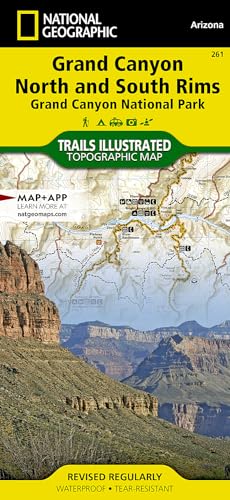
- Waterproof - Tear-Resistant - Topographic MapGrand Canyon, Bright Angel Canyon/North and South Rims (#261) replaces the previous Grand Canyon National Park Trails Illustrated map (#207). Completely redesigned and updated, Grand Canyon Central provides an enhanced scale and detail for the highest visitation area of the park surrounding the Grand Canyon South Rim Visitor Center and the Bright Angel Trail. (Colorado River miles 60-98). Designed with a wide range of visitors in mind, Grand Canyon Central features detailed and easy to read trails, accurate road network, campgrounds, scenic overlooks and points of interests, visitor centers and facilities, color coded bus stops with routes, plus park regulations, backcountry use areas, and contact information for local agencies. This well-balanced mix of detailed cartography and handy resource information makes all Trails Illustrated maps an invaluable resource for both planning and exploring the park. This map features an enhanced scale (35K) for increased detail in this high-use area of Grand Canyon National Park. Features Included: Colorado River miles 60-98, North and South Rim visitor centers, Grand Canyon Village, Grand Canyon / National Geographic IMAX, Tusayan, Grand Canyon Railroad Station, Bright Angel Trail (plus elevation profile), West Rim Trail, Kaibab Trail, Arizona Trail, Grand Canyon Lodge, and more. "Sheet Size = 25.50 x 37.75Folded Size = 4.25 x 9.25Scale = 1:35,000"
Les informations fournies dans la section ½ Synopsis ╗ peuvent faire rķfķrence Ó une autre ķdition de ce titre.
- ╔diteurNATIONAL GEOG
- Date d'ķdition2000
- ISBN 10 1566954959
- ISBN 13 9781566954952
- ReliureCarte
- Nombre de pages1
Acheter neuf
En savoir plus sur cette ķdition
EUR 9,03
Frais de port :
EUR 3,66
Vers Etats-Unis
Meilleurs rķsultats de recherche sur AbeBooks
Image d'archives
Grand Canyon, North and South Rims [Grand Canyon National Park] (National Geographic Trails Illustrated Map)
Editķ par
National Geographic Maps
(2023)
ISBN 10 : 1566954959
ISBN 13 : 9781566954952
Neuf
Quantitķ disponible : 9
Vendeur :
Evaluation vendeur
Description du livre Etat : New. Brand New! Not Overstocks or Low Quality Book Club Editions! Direct From the Publisher! We're not a giant, faceless warehouse organization! We're a small town bookstore that loves books and loves it's customers! Buy from Lakeside Books!. N░ de rķf. du vendeur OTF-S-9781566954952
Acheter neuf
EUR 9,03
Autre devise
Image d'archives
Grand Canyon, North and South Rims [Grand Canyon National Park] (National Geographic Trails Illustrated Map)
Editķ par
National Geographic Maps
(2023)
ISBN 10 : 1566954959
ISBN 13 : 9781566954952
Neuf
Quantitķ disponible : 1
Vendeur :
Evaluation vendeur
Description du livre Etat : New. Buy with confidence! Book is in new, never-used condition 0.2. N░ de rķf. du vendeur bk1566954959xvz189zvxnew
Acheter neuf
EUR 15,95
Autre devise
Image d'archives
Grand Canyon, North and South Rims [Grand Canyon National Park] (National Geographic Trails Illustrated Map)
Editķ par
National Geographic Maps
(2023)
ISBN 10 : 1566954959
ISBN 13 : 9781566954952
Neuf
Quantitķ disponible : 1
Vendeur :
Evaluation vendeur
Description du livre Etat : New. New! This book is in the same immaculate condition as when it was published 0.2. N░ de rķf. du vendeur 353-1566954959-new
Acheter neuf
EUR 15,95
Autre devise
Image d'archives
Grand Canyon National Park. Bright Angel Canyon and North/South Rim #261 (Trails Illustrated)
Editķ par
Natl Geographic Society Maps
(2010)
ISBN 10 : 1566954959
ISBN 13 : 9781566954952
Neuf
Quantitķ disponible : 1
Vendeur :
Evaluation vendeur
Description du livre Map. Etat : New. N░ de rķf. du vendeur DADAX1566954959
Acheter neuf
EUR 15,98
Autre devise
Image d'archives
Grand Canyon, North and South Rims [Grand Canyon National Park] (National Geographic Trails Illustrated Map)
Editķ par
National Geographic Maps
(2023)
ISBN 10 : 1566954959
ISBN 13 : 9781566954952
Neuf
Quantitķ disponible : 16
Vendeur :
Evaluation vendeur
Description du livre Etat : New. N░ de rķf. du vendeur I-9781566954952
Acheter neuf
EUR 16,08
Autre devise
Image d'archives
Grand Canyon, North and South Rims [Grand Canyon National Park] (National Geographic Trails Illustrated Map)
Editķ par
National Geographic Maps
(2019)
ISBN 10 : 1566954959
ISBN 13 : 9781566954952
Neuf
Quantitķ disponible : 4
Vendeur :
Evaluation vendeur
Description du livre Map Fold. Etat : New. **YOUR PURCHASE SUPPORTS A SMALL BUSINESS!!**. N░ de rķf. du vendeur 014414
Acheter neuf
EUR 14,14
Autre devise
Image d'archives
Grand Canyon, Bright Angel Canyon/north & South Rims
Editķ par
National Geographic Maps Division 2012-08-02, Washington, D.C.
(2012)
ISBN 10 : 1566954959
ISBN 13 : 9781566954952
Neuf
Quantitķ disponible : 5
Vendeur :
Evaluation vendeur
Description du livre sheet map (folded). Etat : New. Language: ENG. N░ de rķf. du vendeur 9781566954952
Acheter neuf
EUR 15,59
Autre devise
Image d'archives
Grand Canyon NP 261 Bright Angel GPS ng rv wp Arizona Trails Illustrated National Parks National Geographic Trails Illustrated Map
Editķ par
National Geographic Maps Division
(2012)
ISBN 10 : 1566954959
ISBN 13 : 9781566954952
Neuf
Quantitķ disponible : 2
Vendeur :
Evaluation vendeur
Description du livre UNK. Etat : New. New Book. Shipped from UK. Established seller since 2000. N░ de rķf. du vendeur EA-9781566954952
Acheter neuf
EUR 22,43
Autre devise
Image d'archives
Grand Canyon, North and South Rims [Grand Canyon National Park] (National Geographic Trails Illustrated Map)
Editķ par
National Geographic Maps
(2023)
ISBN 10 : 1566954959
ISBN 13 : 9781566954952
Neuf
Paperback
Quantitķ disponible : 1
Vendeur :
Evaluation vendeur
Description du livre Paperback. Etat : new. New. Fast Shipping and good customer service. N░ de rķf. du vendeur Holz_New_1566954959
Acheter neuf
EUR 19,06
Autre devise
Image d'archives
Grand Canyon, Bright Angel Canyon/north & South Rims (Folded)
Editķ par
National Geographic Maps, Evergreen
(2012)
ISBN 10 : 1566954959
ISBN 13 : 9781566954952
Neuf
Quantitķ disponible : 1
Vendeur :
Evaluation vendeur
Description du livre Folded. Etat : new. Folded. A well-balanced mix of detailed cartography and handy resource information, coverage highlights for this Grand Canyon: Bright Angel Canyon/North and South Rims Trail Map include: Colorado River miles 60-98, North and South Rim visitor centers, Grand Canyon Village, Grand Canyon / National Geographic IMAX, Tusayan, Grand Canyon Railroad Station, Bright Angel Trail (plus elevation profile), West Rim Trail, Kaibab Trail, Arizona Trail, Grand Canyon Lodge, and more. A necessity for exploring in the outdoors, this map is printed on waterproof, tear-resistant material. National Geographic's Trails Illustrated Maps are the most detailed and up-to-date topographic recreation maps available for US National Parks, National Forests and other popular outdoor recreation areas. A necessity for exploring the outdoors, each map is printed on waterproof, tear-resistant material. They also contain key safety and contact information, GPS and compass coordinates, Leave No Trace ethical guidelines and hundreds of points-of-interest, including scenic viewpoints, campgrounds, boat launches, swimming areas, marine sanctuaries and wildlife refuges. Shipping may be from multiple locations in the US or from the UK, depending on stock availability. N░ de rķf. du vendeur 9781566954952
Acheter neuf
EUR 22,78
Autre devise