Articles liés ŕ Wellingborough, Rushden and District 1897: One Inch...
L'édition de cet ISBN n'est malheureusement plus disponible.
Afficher les exemplaires de cette édition ISBN
- ÉditeurAlan Godfrey Maps
- Date d'édition2000
- ISBN 10 184151201X
- ISBN 13 9781841512013
- ReliureCarte
Acheter neuf
En savoir plus sur cette édition
EUR 13,71
Frais de port :
Gratuit
Vers Etats-Unis
Meilleurs résultats de recherche sur AbeBooks
Image d'archives
Wellingborough, Rushden and District 1897 One Inch Map 186 Old Ordnance Survey Maps of England Wales
Edité par
Alan Godfrey Maps
(2000)
ISBN 10 : 184151201X
ISBN 13 : 9781841512013
Neuf
Quantité disponible : 1
Vendeur :
Evaluation vendeur
Description du livre UNK. Etat : New. New Book. Shipped from UK. Established seller since 2000. N° de réf. du vendeur GB-9781841512013
Acheter neuf
EUR 13,71
Autre devise
Image d'archives
Wellingborough, Rushden And District 1897
Edité par
Alan Godfrey Maps
(2000)
ISBN 10 : 184151201X
ISBN 13 : 9781841512013
Neuf
Quantité disponible : 1
Vendeur :
Evaluation vendeur
Description du livre Map. Etat : Brand New. 8.31x4.76x0.04 inches. In Stock. N° de réf. du vendeur __184151201X
Acheter neuf
EUR 4,02
Autre devise
Image d'archives
Wellingborough, Rushden and District 1897: One Inch Map 186
Edité par
Alan Godfrey Maps
(2000)
ISBN 10 : 184151201X
ISBN 13 : 9781841512013
Neuf
Quantité disponible : 1
Vendeur :
Evaluation vendeur
Description du livre Sheet map, folded. Etat : New. New copy - Usually dispatched within 4 working days. N° de réf. du vendeur B9781841512013
Acheter neuf
EUR 5,89
Autre devise
Image d'archives
Wellingborough, Rushden and District 1897: One Inch Map 186 (Old Ordnance Survey Maps of England & Wales)
Edité par
Alan Godfrey Maps
(2000)
ISBN 10 : 184151201X
ISBN 13 : 9781841512013
Neuf
Quantité disponible : 1
Vendeur :
Evaluation vendeur
Description du livre Map. Etat : New. BRAND NEW ** SUPER FAST SHIPPING FROM UK WAREHOUSE ** 30 DAY MONEY BACK GUARANTEE. N° de réf. du vendeur 9781841512013-GDR
Acheter neuf
EUR 7,10
Autre devise
Image d'archives
Wellingborough, Rushden and District 1897: One Inch Map 186 (Old Ordnance Survey Maps of England & Wales)
Edité par
Alan Godfrey Maps
(2000)
ISBN 10 : 184151201X
ISBN 13 : 9781841512013
Neuf
Quantité disponible : 1
Vendeur :
Evaluation vendeur
Description du livre Etat : New. In. N° de réf. du vendeur ria9781841512013_new
Acheter neuf
EUR 6,65
Autre devise
Image d'archives
Wellingborough, Rushden and District 1897 (Old Ordnance Survey Maps)
Edité par
The Godfrey Edition
(2000)
ISBN 10 : 184151201X
ISBN 13 : 9781841512013
Neuf
Quantité disponible : 1
Vendeur :
Evaluation vendeur
Description du livre Etat : New. 2000. Map. Series: Old Ordnance Survey Maps of England & Wales. BIC Classification: 1DBKEMM; 3JH; WQH; WTRM. Category: (G) General (US: Trade). Dimension: 112 x 214 x 2. Weight in Grams: 24. One Inch Map 186. Series: Old Ordnance Survey Maps of England & Wales. Cateogry: (G) General (US: Trade). BIC Classification: 1DBKEMM; 3JH; WQH; WTRM. Dimension: 112 x 214 x 2. Weight: 26. . . . . . Books ship from the US and Ireland. N° de réf. du vendeur V9781841512013
Acheter neuf
EUR 13,08
Autre devise
Image d'archives
Wellingborough, Rushden and District 1897 (Old Ordnance Survey Maps)
Edité par
The Godfrey Edition
(2000)
ISBN 10 : 184151201X
ISBN 13 : 9781841512013
Neuf
Quantité disponible : 1
Vendeur :
Evaluation vendeur
Description du livre Etat : New. 2000. Map. Series: Old Ordnance Survey Maps of England & Wales. BIC Classification: 1DBKEMM; 3JH; WQH; WTRM. Category: (G) General (US: Trade). Dimension: 112 x 214 x 2. Weight in Grams: 24. One Inch Map 186. Series: Old Ordnance Survey Maps of England & Wales. Cateogry: (G) General (US: Trade). BIC Classification: 1DBKEMM; 3JH; WQH; WTRM. Dimension: 112 x 214 x 2. Weight: 26. . . . . . N° de réf. du vendeur V9781841512013
Acheter neuf
EUR 14,43
Autre devise
Image fournie par le vendeur
Wellingborough, Rushden and District 1897 : One Inch Map 186
Edité par
Alan Godfrey Maps Sep 2000
(2000)
ISBN 10 : 184151201X
ISBN 13 : 9781841512013
Neuf
Quantité disponible : 2
Vendeur :
Evaluation vendeur
Description du livre Karte. Etat : Neu. Neuware Deutsch. N° de réf. du vendeur 9781841512013
Acheter neuf
EUR 4,43
Autre devise
Image d'archives
Wellingborough, Rushden and District 1897 One Inch Map 186 Old Ordnance Survey Maps of England Wales
Edité par
Alan Godfrey Maps
(2000)
ISBN 10 : 184151201X
ISBN 13 : 9781841512013
Neuf
Quantité disponible : 1
Vendeur :
Evaluation vendeur
Description du livre UNK. Etat : New. New Book. Shipped from UK. Established seller since 2000. N° de réf. du vendeur GB-9781841512013
Acheter neuf
EUR 8,90
Autre devise
Image d'archives
Wellingborough, Rushden and District 1897: One Inch Map 186 (Old Ordnance Survey Maps of England & Wales)
Edité par
Alan Godfrey Maps
(2000)
ISBN 10 : 184151201X
ISBN 13 : 9781841512013
Neuf
Quantité disponible : 1
Vendeur :
Evaluation vendeur
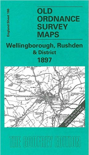
Description du livre No Binding. Etat : New. No Jacket. Here is information about Sheet 186: One Inch Sheet 186 Wellingborough, Rushden & District 1897 - published 2000; intro by Barrie Trinder. ISBN.978-1-84151-201-3 This One Inch to the Mile map portrays an area of east Northamptonshire and north Bedfordshire, centred on Higham Ferrers. Wellingborough is the principal town on the map but interestingly the OS give town status to Higham Ferrers and - further east - Kimbolton, but not to Rushden. Coverage of the map stretches from Cogenhoe eastward to Kimbolton, and from Woodford and Denford southward to Castle Ashby. Railways, apart from the Midland line, include the Northampton & Peterborough Branch and Kettering & Huntingdon Branch. There is plentiful evidence of iron ore extraction. On the reverse we include a map of Finedon, with a commercial directory. It is not possible to list the many hamlets, farmsteads and other topographical features shown on these maps. However, you may find it useful if we list the towns and principal villages or church parishes that are included on this map. Links are given for those for which detailed large-scale maps are also available. Bedfordshire: Bletsoe, Bolnhurst, Colmworth, Felmersham, Keysoe, Knotting, Little Staughton, Melchbourne, Odell, Pertenhall, Podington, Riseley, Sharnbrook, Shelton, Souldrop, Swineshead, Thurleigh, Upper Dean, Wymington, Yelden. Huntingdonshire: Brington, Bythorn, Catworth, Covington, Kimbolton, Leighton Bromswold, Long Stow, Molesworth, Tilbrook. Northamptonshire: Bozeat, Broughton, Burton Latimer, Castle Ashby, Chelveston, Cogenhoe, Cranford St John, Denford, Denton, Earls Barton, Easton Maudit, Ecton, Finedon, Great Addington, Great Doddington, Great Harrowden, Grendon, Hardwick, Higham Ferrers, Irchester, Irthlingborough, Isham, Little Addington, Little Harrowden, Mears Ashby, Newton Bromswold, Orlingbury, Pytchley, Raunds, Ringstead, Rushden, Stanwick, Strixton, Wellingborough, Whiston, Wilby, Wollaston, Woodford. N° de réf. du vendeur 003789
Acheter neuf
EUR 3,31
Autre devise