
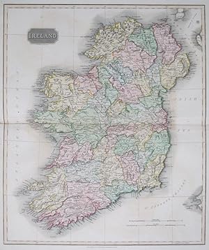
Ireland
THOMSON, John.
Edité par EdinburghJohn Thomson. 1817, 1815
Ancien(s) ou d'occasion
/
Quantité disponible : 0
Disponible auprčs d'autres vendeurs
Afficher tous les exemplaires de ce livre
Au sujet du livre
Ce livre n'est malheureusement plus disponible. Ci-dessous, nous vous proposons d'autres livres correspondant ŕ Ireland de THOMSON, John..
Description :
59 x 50 cm. (Sheet 70 x 55 cm.) Original full hand-colour. Double page map of Ireland. Minor repair to centrefold. Issued in the 1817 edition of Thomson's 'New General Atlas'. N° de réf. du vendeur 45779
Détails bibliographiques
Titre : Ireland
Éditeur : EdinburghJohn Thomson. 1817
Date d'édition : 1815
Meilleurs résultats de recherche sur AbeBooks
1. On the surgical anatomy of the prostate : (the introduction to a discussion on the surgical anatomy of the prostate at the Anatomical Society of Great Britain and Ireland, November 21, 1905) [LeatherBound]
Neuf
Couverture rigide
Quantité disponible : 18
Vendeur :
Evaluation vendeur
Description du livre LeatherBound. Etat : New. Leather Binding on Spine and Corners with Golden leaf printing on spine. Bound in genuine leather with Satin ribbon page markers and Spine with raised gilt bands. A perfect gift for your loved ones. Reprinted from 1906 edition. NO changes have been made to the original text. This is NOT a retyped or an ocr'd reprint. Illustrations, Index, if any, are included in black and white. Each page is checked manually before printing. As this print on demand book is reprinted from a very old book, there could be some missing or flawed pages, but we always try to make the book as complete as possible. Fold-outs, if any, are not part of the book. If the original book was published in multiple volumes then this reprint is of only one volume, not the whole set and contains approximately 26 pages. IF YOU WISH TO ORDER PARTICULAR VOLUME OR ALL THE VOLUMES YOU CAN CONTACT US. Resized as per current standards. Sewing binding for longer life, where the book block is actually sewn (smythe sewn/section sewn) with thread before binding which results in a more durable type of binding. Language: English. N° de réf. du vendeur LB990001238657
Acheter neuf
EUR 31,68
Autre devise
2. Northern part of Ireland
Ancien ou d'occasion
Quantité disponible : 1
Vendeur :
Evaluation vendeur
Description du livre Etat : Good. Northern part of Ireland. Ulster south to Dublin. Coach roads. THOMSON 1830 map. Antique early 19th century atlas map with original hand colouring; Drawn & engraved by Samuel John Neele for John Thomson's "New General Atlas" (1830). 52.5 x 63.0cm, 20.75 x 24.75 inches; this is a folding map. Condition: Good. Please contact us if you would like to arrange to view this map. There is nothing printed on the reverse side, which is plain. N° de réf. du vendeur P-8-001665
Acheter D'occasion
EUR 238,99
Autre devise
3. Southern part of Ireland
Ancien ou d'occasion
Quantité disponible : 1
Vendeur :
Evaluation vendeur
Description du livre Etat : Good. Southern part of Ireland. Munster Leinster. Coach roads. THOMSON 1830 old map. Antique early 19th century atlas map with original hand colouring; Drawn & engraved by Samuel John Neele for John Thomson's "New General Atlas" (1830). 52.0 x 61.5cm, 20.5 x 24.25 inches; this is a folding map. Condition: Good. Please contact us if you would like to arrange to view this map. There is nothing printed on the reverse side, which is plain. N° de réf. du vendeur P-8-001666
Acheter D'occasion
EUR 238,99
Autre devise
4. Northern part of Ireland
Ancien ou d'occasion
Quantité disponible : 1
Vendeur :
Evaluation vendeur
Description du livre Etat : Good. Northern part of Ireland. Ulster south to Dublin. Coach roads. THOMSON 1817 map. Antique early 19th century atlas map with original hand colouring; Drawn & engraved by Samuel John Neele for John Thomson's "New General Atlas" (Published in 1817). 51.5 x 62.5cm, 20.25 x 24.5 inches; this is a folding map. Condition: Good. Please contact us if you would like to arrange to view this map. There is nothing printed on the reverse side, which is plain. N° de réf. du vendeur P-8-003684
Acheter D'occasion
EUR 275,02
Autre devise
5. Southern part of Ireland
Ancien ou d'occasion
Quantité disponible : 1
Vendeur :
Evaluation vendeur
Description du livre Etat : Good. Southern part of Ireland. Munster Leinster. Coach roads. THOMSON 1817 old map. Antique early 19th century atlas map with original hand colouring; Drawn & engraved by Samuel John Neele for John Thomson's "New General Atlas" (Published in 1817). 52.0 x 61.5cm, 20.5 x 24.25 inches; this is a folding map. Condition: Good. Please contact us if you would like to arrange to view this map. There is nothing printed on the reverse side, which is plain. N° de réf. du vendeur P-8-003685
Acheter D'occasion
EUR 275,02
Autre devise
6. Ireland
Ancien ou d'occasion
Quantité disponible : 1
Vendeur :
Evaluation vendeur
Description du livre Etat : Fair. "Ireland" by John Thomson. Coach roads 1817 old antique vintage map plan chart. Antique early 19th century atlas map with original hand colouring; Drawn & engraved by Samuel John Neele for John Thomson's "New General Atlas" (Published in 1817. Engraved in February 1815; this date is marked on the map). 64.0 x 52.0cm, 25 x 20.5 inches; this is a folding map. Condition: Fair: Toning along centrefold. Please contact us if you would like to arrange to view this map. There is nothing printed on the reverse side, which is plain. N° de réf. du vendeur P-8-003683
Acheter D'occasion
EUR 323,05
Autre devise
7. Northern Part of Ireland [with] Southern Part of Ireland .
Edité par
EdinburghJohn Thomson.
(1828)
Ancien ou d'occasion
Quantité disponible : 1
Vendeur :
Evaluation vendeur
Description du livre 2 double page maps c.50 x 59 cm. each . (Sheets 54 x 69 cm.). Original hand-colour. Inset vignettes of the Giant's Causeway and the Bank of Ireland. Slight staining to margins outside the maps. Issued in the 1828 edition of Thomson's 'New General Atlas'. N° de réf. du vendeur 49067
Acheter D'occasion
EUR 360,28
Autre devise
8. Ireland From 'A New General Atlas, consisting of A Series of Geographical Designs, on Various Projections, Exhibiting the Form and Component Parts of the Globe; and A Collection of Maps and Charts, Delineating the Natural and Political Divisions of the Empires, Kingdoms and States of the World'.
Edité par
John Thomson & Company, Edinburgh, UK
(1815)
Ancien ou d'occasion
Quantité disponible : 1
Vendeur :
Evaluation vendeur
Description du livre No Binding. Etat : Very Good. Sheet size: 68cm x 53.8cm. From 'A New General Atlas, consisting of A Series of Geographical Designs, on Various Projections, Exhibiting the Form and Component Parts of the Globe; and A Collection of Maps and Charts, Delineating the Natural and Political Divisions of the Empires, Kingdoms and States of the World'. Date c.1814-1816. Crease to central fold line. Blank to the reverse. Age-toning, minor off-setting and slight foxing as usual. Original hand-colouring nice and bright. In very good, bright, clean condition. This is one of a number of these maps that we are currently posting. Please see our other listings or use the keyword: hornseysthomson. N° de réf. du vendeur 001481
Acheter D'occasion
EUR 360,28
Autre devise