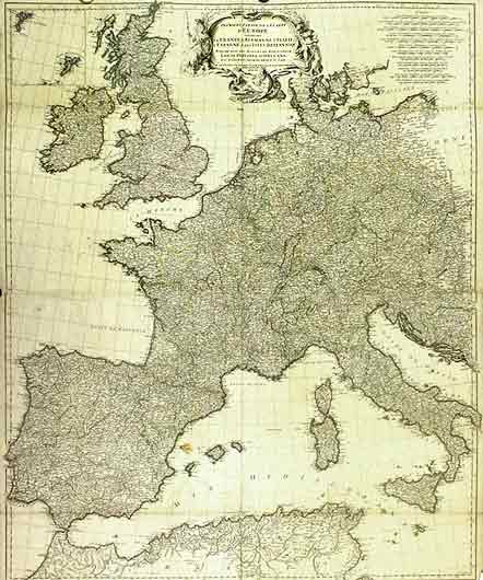
Prémičre Partie de la carte d?Europe.
D?ANVILLE
Edité par Publiée sous les auspices de Monseigneur Louis Philippe d`Orléans premier Prince du Sang. MDCCLIV, 1754,
Ancien(s) ou d'occasion
/
Quantité disponible : 0
Disponible auprčs d'autres vendeurs
Afficher tous les exemplaires de ce livre
Au sujet du livre
Ce livre n'est malheureusement plus disponible. Ci-dessous, nous vous proposons d'autres livres correspondant ŕ Prémičre Partie de la carte d?Europe. de D?ANVILLE.
Description :
84x100 cm Carte en 16 éléments montées sur toile d?époque, contenant la France, l`Allemagne, l`Italie, l`Espagne, & les Iles Britanniques. carte pliée 26x21.5 cm. (frontičres en couleurs / Map coloured in outline). Please notify before visiting to see a book. Prices are excl. VAT/TVA (only Switzerland) & postage. N° de réf. du vendeur GR950
Détails bibliographiques
Titre : Prémičre Partie de la carte d?Europe.
Éditeur : Publiée sous les auspices de Monseigneur Louis Philippe d`Orléans premier Prince du Sang. MDCCLIV, 1754,
Meilleurs résultats de recherche sur AbeBooks
1. Premiere Partie de la Carte d'Europe contenant la France, l'Alemagne, l'Italie, l'Espagne & les Isles Britanniq." - Western Europe Italy Spain British Isles Germany map Karte
Edité par
Paris
(1754)
Ancien ou d'occasion
Quantité disponible : 1
Vendeur :
Evaluation vendeur
Description du livre Großformatige altkolorierte originalKupferstich-Kartevon 1754. Von 2 Platten gedruckt und zusammensetzbar. - Blattmasse: jede Karte ca. 55 x 82 cm -- obere Karte im unteren Mittelbug etwas hinterlegt, sonst gut erhalten. || Large old colored original copper engraved map from 1754. Printed on two plates, can be joined together. -- upper map deposited on the lower part of the centerfold, otherwise in good condition. || Dies ist ein Original! - Kein Nachdruck! - Keine Kopie! -- This is an original! No copy! - No reprint! Sprache: Französisch Gewicht in Gramm: 100. N° de réf. du vendeur 245972
Acheter D'occasion
EUR 350
Autre devise
2. Prémičre partie de la carte d'Europe contenant La France, L'Alemagne, L'Italie, L'Espagne, & les Isles Britanniq.s. Publiée sous les auspices de Monseigneur Louis Philippe d'Orléans, duc d'Orléans Premier Prince du Sang
Ancien ou d'occasion
Quantité disponible : 1
Vendeur :
Evaluation vendeur
Description du livre Etat : Good. 'Prémičre partie de la carte d'Europe'. D'ANVILLE. Western Europe 1756 old map. Large antique 18th century atlas wall map, printed on thick, good quality paper with original hand colour/color and decorative title cartouche; Jean Baptiste Bourguignon d'Anville. Ornamental cartouche by N. Le Mire (1756). 100.0 x 82.0cm, 39.25 x 32.25 inches; this is a folding map. Condition: Good. The map is in generally good condition and presents well. However, the centrefold is misfolded above upper horizontal fold and there is a repaired split to the upper part of the centrefold which would benefit from some further attention. Please contact us if you would like to arrange to view this map. There is nothing printed on the reverse side, which is plain. N° de réf. du vendeur P-9-000048
Acheter D'occasion
EUR 839,54
Autre devise