A propos de cet article
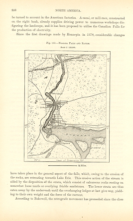
NIAGARA FALLS AND RAPIDS,CANADA ,Antique Historical Relief Map NIAGARA FALLS AND RAPIDS,CANADA 1893 WOOD ENGRAVED HISTORICAL MAPAntique Topographical Map CLOSEUP . Approx Image Size : 4 X 5 inches Approx Overall Size: 7 X 10 1/2 inches Scale : 1: 120,000, Niagara Falls is a set of massive waterfalls located on the Niagara River in eastern North America, on the border between the United States and Canada. Niagara Falls (French: les Chutes du Niagara) comprises three separate waterfalls: the Horseshoe Falls (sometimes called the Canadian Falls), the American Falls, and the smaller, adjacent Bridal Veil Falls. While not exceptionally high, Niagara Falls is very wide. With more than 6 million cubic feet (168,000 m ) of water falling over the crestline every minute it is the most powerful waterfall in North America and possibly the best-known in the world. The name "Niagara" is said to originate from an Iroquois word "Onguiaahra" meaning "The Strait." The region's original inhabitants were the Ongiara, an Iroquois tribe named the Neutrals by French settlers, who found them helpful in mediating disputes with other tribes. Native American legend tells of Lelawala, a beautiful maid betrothed by her father to a brave she despised. Rather than marry, Lelawala chose to sacrifice herself to her true love He-No, the Thunder God, who dwelt in a cave behind the Horseshoe Falls. She paddled her canoe into the swift current of the Niagara River and was swept over the brink. He-No caught her as she plummeted, and together their spirits are said to live forever in the Thunder God's sanctuary behind the Falls. Some controversy exists over which European first gave a written, eyewitness description of the Falls. The area was visited by Samuel de Champlain as early as 1604. Members of his party reported to him on the spectacular waterfalls, which he wrote of in his journals but may never have actually visited. Some credit Finnish-Swedish naturalist Pehr Kalm with the original first-hand description, penned during an expedition to the area early in the 18th century.3 Most historians however agree that Father Louis Hennepin observed and described the Falls much earlier, in 1677, after traveling in the region with explorer Ren� Robert Cavelier, Sieur de la Salle, thus bringing them to the world's attention. Hennepin also first described the Saint Anthony Falls in Minnesota. His subsequently discredited claim that he also traveled the Mississippi River to the Gulf of Mexico cast some doubt on the validity of his writings and sketches of Niagara Falls. Hennepin County in Minnesota was named after Father Louis Hennepin. During the 19th century tourism became popular, and it was the area's main industry by mid-century. Napoleon's brother J�r�me Bonaparte visited with his bride in the early 19th century. Demand for passage over the Niagara River led in 1848 to the building of a footbridge and then Charles Ellet's Niagara Suspension Bridge. This was supplanted by German-American John Augustus Roebling's Niagara Falls Suspension Bridge in 1855. After the American Civil War, the New York Central railroad publicized Niagara Falls as a focus of pleasure and honeymoon visits. With increased railroad traffic, in 1886 Leffert Buck replaced Roebling's wood and stone bridge with the predominantly steel bridge that still carries trains over the Niagara River today. The first steel archway bridge near the Falls was completed in 1897. Known today as the Whirlpool Rapids Bridge, it carries vehicles, trains, and pedestrians between Canada and the U.S. just below the Falls. The Niagara River - The total drop in elevation along the river is 99 meters (326 feet). The Upper Niagara Rapids drop 15 m in the 800 m before the Falls. The Niagara Gorge extends 11.26 km (7 mi.) downstream from the Falls and includes the Niagara Whirlpool and another section of rapids. The Niagara River features two large islands, Grand Island and Goat Island, both in the United States. The western.
N� de r�f. du vendeur 8343
Contacter le vendeur
Signaler cet article


