Passer au contenu principal
abebooks.fr
Chercher
Ouvrir une session
Votre compte
Panier
Aide
Menu
Votre compte
Vos commandes
Recherche avancée
Collections
Livres anciens
Art & Collection
Vendeurs
Devenir vendeur
Aide
Fermer
alte Landkarten
Proposé par
Alte Bücherwelt
Plus populaires
Ajouts récents
Prix croissant
Orig. Astronomische Karte "Division Astronomique due Globe Terrrestre.", ca. 1800 En Cercles Zone...
1800
Der Hafen der Stadt Cayenne, Französisch-Guyana Original-Kupferstich koloriert
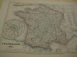
France, Original Landkarte (Kupfer)
Kitchin, Thomas:
Der vermessene Planet Bilderatlas zur Geschichte der Kartographie
Sammet, Gerald:
1990
Edition originale
Carte Physique de L`Hidoustan et de L`Indo-Chine
Dufour, A.H.:
1840
A Map of the Empire of Germany Landkarte Deutsches Reich
Amerique Meridionale
Bonne, M.:
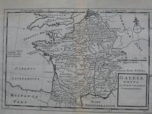
Gallia
Moll, Hermann:
Orig. Landkarte England 1823 Walker`s Atlas
Hall, Sid.:
1823
Orig. Landkarte "Europe par A.H. Dufour
Tardieu, Pierre:
1839
Orig. "Plan of the River Sarebus taken on Board the Boats of H.M. S. Dido". 1843
Wyld, James:
1846
Orig. Landkarte "East India Islands On Mercator`s Projection" ca. 1820
1820
France par Provinces et Paris en 1789
Bocage, J.G. Barbié, du:
1843
Spanien und Portugal
Stülpnagel, F., von:
1870
map "Océanie"
Vuillemin:
1840
Mexico u. Central-Amerika
Baur, C. und Tr. Bromme:
1850
Sibérie ou Russie d`Asie par A.H. Dufour
Dufour, A.H.:
1850
A Chart of France from l`Orient to St. Gilles
Sammlung Mittelalterlicher Welt- und Seekarten Italienischen Ursprungs und aus Italienischen.
Fischer, Theobald, Dr.:
1961
Orig. Landkarte "Italian States"
Starling, T.:
1850
Orig. Landkarte "Italie 1827"
1827
Orig. Landkarte "Russia & Poland" ca. 1840
Hughes, W.:
1840
Orig. Landkarte "Frankreich 1849"
Radefeld, Hptm.:
1849
Guatemala or United States of Central America, 1841
Wyld, James:
1841
Orig. Landkarte "Timor and other Islands between it and N. Guinea" ca. 1780
1780
Orig. Landkarte "Switzerland Walker`s Atlas" 1823
Hall, Sydney:
1823
A Comparative View of The Principal Waterfalls, Islands, Lakes, Rivers and Mountains in the Western
Rapkin, John:
1850
Orig. Landkarte "Africa" ca. 1820
Rapkin, J.:
1820
Orig. Landkarte "Spain & Portugal" 1860
Hall, S.:
1860
Orig. Landkarte "Russie d`Europe Atlas Delamarche Geographie Moderne
Delamarche:
1840
Orig. Landkarte (Seekarte) Timor, ca. 1800
1800
Orig. Landkarte (Seekarte) New Guinea, ca. 1800
1800
Orig. Landkarte "Partie de la Terre Ferme De L`Inde ou l`Empire du Mogul, 1683
1683
Orig. Landkarte "Physical Geographie" 1854
Aikman, Geo.:
1854
Tabellen und Karten zur Weltgeschichte
Lange, Otto, Dr.:
1870
Kartographische Ortsnamenkunde Probleme und Richtlinien der Kartenbeschriftung mit Musterbeispiel...
Weygandt, Helmut:
1955
Alemagne comprenant, la confederation Germanique, L`Autriche, la Prusse et la Pologne
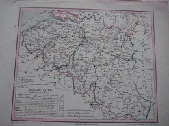
Belgique
Monin, C. V.:
1866
Germania Antiqua
Hall, Sydney:
1820
Russie D`Europe
1840
Prussia
1850
Physikalische Karte vom Indischen Meere
Kleinknecht:
1867
De Srait Sunda
1780
The Solar-System, The Moon
1895
Constellations of the Northern and the Southern Hemisphere
1895
Carta Generale della Germania ossia confederazione germanica (Europa Centrale)
Marzolla, Pa.:
1849
Coste Occidentale d` Afrique depuis le Detroit de Gibraltar
Maurepas, Comte de:
1738
Sketch map of the Dutch Possessions in the Indian Archipelago
Bartholomew, J.:
1840
Das Europäische Russland
Renner:
1849
Das Asiatische Russland jenseits des Ural
Renner:
1858
England and Wales from the best Authorities
1820
A new map of Bedfordshire drawn from the latest Authorities
1830
Spain and Portugal
Russell, J.:
1814
Germany from the best Authorities
1820
Carte de la Chaine des Alpes
Dussieux, L.:
1846
Carte physique et politique de L`empire d`Autriche
Dussieux, L.:
1853
La Gaule sous l`Empire Romain
Dufour, A.H.:
1855
La Gaule
Herisson und Glot:
1820
Germania, Pannonia d`Acia et Sarmatia
Dufour, A.H.:
1833
Landkarte "South America from the best Authorities"
1797
Plus de résultats