Montant total (1 article articles) :
Destination de la commande :

ABERCROMBIE, PATRICK (267 résultats)
Passer aux résultats principaux de la recherche
Type d'article
- Tous les types d'articles
- Livres (155)
- Magazines & Périodiques
- Bandes dessinées
- Partitions de musique
- Art, Affiches et Gravures (6)
- Photographies
- Cartes (105)
-
Manuscrits &
Papiers anciens (1)
Etat
Reliure
Particularités
Livraison gratuite
Pays
Evaluation du vendeur
-
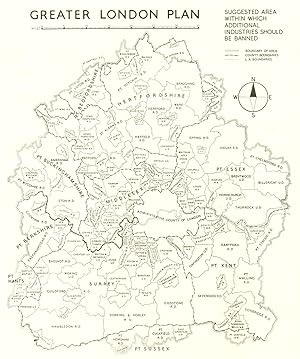
Greater London Plan; Suggested area within which additional industries should be banned
Date d'édition : 1944
Carte
Etat : Good. GREATER LONDON. Proposed area to ban additional industry. ABERCROMBIE 1944 map. Vintage town planning map; Patrick Abercrombie (1944). 25.0 x 21.0cm, 9.75 x 8.25 inches. Condition: Good. The image shown may have been taken from a different example of this map than that which is offered for sale. The map you will receive is in good condition but there may be minor variations in the condition from that shown in the image. There are images and/or text printed on the reverse side of the picture. In some cases this may be visible on the picture itself or around the margin of the picture.
-
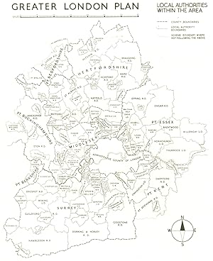
Etat : Good. GREATER LONDON PLAN. Local authorities within the area. ABERCROMBIE 1944 map. Vintage town planning map; Patrick Abercrombie (1944). 24.5 x 19.5cm, 9.5 x 7.75 inches. Condition: Good. The image shown may have been taken from a different example of this map than that which is offered for sale. The map you will receive is in good condition but there may be minor variations in the condition from that shown in the image. There are images and/or text printed on the reverse side of the picture. In some cases this may be visible on the picture itself or around the margin of the picture.
-
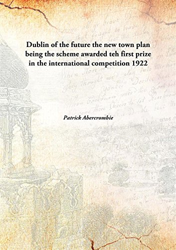
Dublin of the futurethe new town plan being the scheme awarded teh first prize in the international competition [HARDCOVER]
Edité par Isha Books, 2013
ISBN 10 : 9333121099ISBN 13 : 9789333121095
Livre
Etat : New. pp. 161.
Plus de choix d'achat de la part d'autres vendeurs sur AbeBooks
Offres neuf ŕ partir de EUR 11,90
-
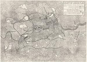
Etat : Good. LONDON. Period Planning. 1st & 2nd Proposals; plan 1943 old vintage map chart. Vintage map; Abercrombie, Patrick (1943). 17.5 x 24.5cm, 6.75 x 9.5 inches. Condition: Good. The image shown may have been taken from a different example of this map than that which is offered for sale. The map you will receive is in good condition but there may be minor variations in the condition from that shown in the image. There are images text around the image.
-
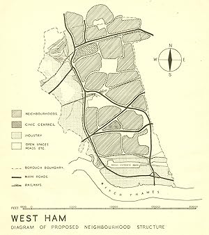
Etat : Good. WEST HAM. Proposed postwar neighbourhood structure. ABERCROMBIE 1944 old map. Vintage town planning map; Patrick Abercrombie (1944). 23.5 x 21.0cm, 9.25 x 8.25 inches. Condition: Good. Verso text quite apparent; The image shown may have been taken from a different example of this map than that which is offered for sale. The map you will receive is in good condition but there may be minor variations in the condition from that shown in the image. There are images and/or text printed on the reverse side of the picture. In some cases this may be visible on the picture itself or around the margin of the picture.
-
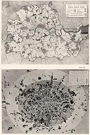
The Park System; 3. Open space Plan for the county; 4. Regional park system
Date d'édition : 1943
Carte
Etat : Good. LONDON. Open spaces & Park system. space plan; Region & City 1943 old map. Vintage map; Abercrombie, Patrick (1943). 31.0 x 20.5cm, 12 x 8 inches. Condition: Good. The image shown may have been taken from a different example of this map than that which is offered for sale. The map you will receive is in good condition but there may be minor variations in the condition from that shown in the image. The map has been printed up to the edges of the paper, as issued, hence there are no margins or borders. There are images text around the image.
-
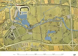
Etat : Good. LEE VALLEY. Broxbourne. Planned recreation centre. ABERCROMBIE 1944 old map. Vintage colour town planning map; Patrick Abercrombie (1944). 22.0 x 30.5cm, 8.75 x 12 inches. Condition: Good. The map has been printed up to the edges of the paper, as issued, hence there are no margins or borders; The image shown may have been taken from a different example of this map than that which is offered for sale. The map you will receive is in good condition but there may be minor variations in the condition from that shown in the image. There are images and/or text printed on the reverse side of the picture. In some cases this may be visible on the picture itself or around the margin of the picture.
-
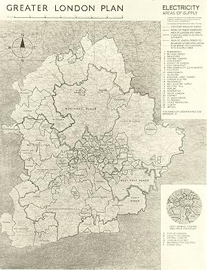
Etat : Good. GREATER LONDON PLAN. Electricity. Areas of supply. ABERCROMBIE 1944 old map. Vintage town planning map; Patrick Abercrombie (1944). 25.0 x 19.0cm, 9.75 x 7.5 inches. Condition: Good. The image shown may have been taken from a different example of this map than that which is offered for sale. The map you will receive is in good condition but there may be minor variations in the condition from that shown in the image. There are images and/or text printed on the reverse side of the picture. In some cases this may be visible on the picture itself or around the margin of the picture.
-
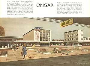
Etat : Good. CHIPPING ONGAR. Proposed postwar High Street development. ABERCROMBIE 1944. Vintage colour print; Patrick Abercrombie (1944). 22.5 x 30.5cm, 8.75 x 12 inches. Condition: Good. The print has been printed up to the edges of the paper, as issued, hence there are no margins or borders; The image shown may have been taken from a different example of this print than that which is offered for sale. The print you will receive is in good condition but there may be minor variations in the condition from that shown in the image. There are images and/or text printed on the reverse side of the picture. In some cases this may be visible on the picture itself or around the margin of the picture.
-
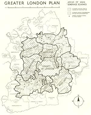
Etat : Good. GREATER LONDON PLAN. Areas of main Sewerage schemes. ABERCROMBIE 1944 old map. Vintage town planning map; Patrick Abercrombie (1944). 24.5 x 19.5cm, 9.75 x 7.75 inches. Condition: Good. The image shown may have been taken from a different example of this map than that which is offered for sale. The map you will receive is in good condition but there may be minor variations in the condition from that shown in the image. There are images and/or text printed on the reverse side of the picture. In some cases this may be visible on the picture itself or around the margin of the picture.
-
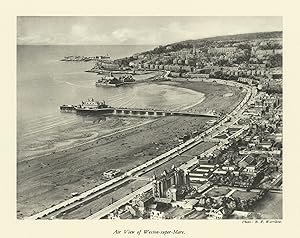
Etat : Good. Air View of Weston-super-Mare 1930 old vintage print picture. Vintage print; Patrick Abercrombie (1930). 18.0 x 22.5cm, 7 x 8.75 inches. Condition: Good. There is nothing printed on the reverse side, which is plain.
-
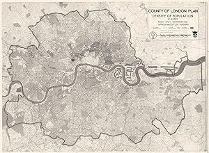
Etat : Good. LONDON. Survey of pre- war population densities 1943 old vintage map chart. Vintage map; Abercrombie, Patrick (1943). 18.0 x 24.5cm, 7 x 9.5 inches. Condition: Good. The image shown may have been taken from a different example of this map than that which is offered for sale. The map you will receive is in good condition but there may be minor variations in the condition from that shown in the image. The map has been printed up to the edges of the paper, as issued, hence there are no margins or borders. There are images text around the image.
-
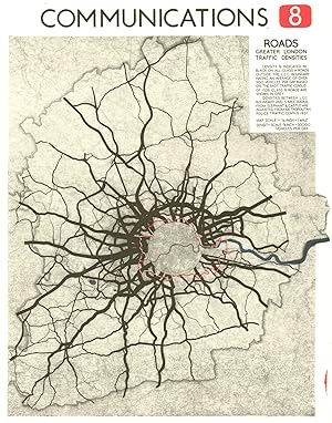
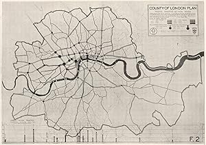
Etat : Good. LONDON. Communications. Traffic Densities 1943 old vintage map plan chart. Vintage map; Abercrombie, Patrick (1943). 17.0 x 24.5cm, 6.75 x 9.5 inches. Condition: Good. The image shown may have been taken from a different example of this map than that which is offered for sale. The map you will receive is in good condition but there may be minor variations in the condition from that shown in the image. The map has been printed up to the edges of the paper, as issued, hence there are no margins or borders. There are images text around the image.
-
Etat : Good. HATFIELD. Proposed town extension & airport. London Plan. ABERCROMBIE 1944 map. Vintage colour town planning map; Patrick Abercrombie (1944). 22.0 x 30.5cm, 8.75 x 12 inches. Condition: Good. The map has been printed up to the edges of the paper, as issued, hence there are no margins or borders; The image shown may have been taken from a different example of this map than that which is offered for sale. The map you will receive is in good condition but there may be minor variations in the condition from that shown in the image. There are images and/or text printed on the reverse side of the picture. In some cases this may be visible on the picture itself or around the margin of the picture.
-
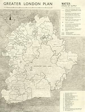
Etat : Good. GREATER LONDON PLAN. Water. Areas of supply. ABERCROMBIE 1944 old vintage map. Vintage town planning map; Patrick Abercrombie (1944). 25.0 x 19.0cm, 9.75 x 7.5 inches. Condition: Good. The image shown may have been taken from a different example of this map than that which is offered for sale. The map you will receive is in good condition but there may be minor variations in the condition from that shown in the image. There are images and/or text printed on the reverse side of the picture. In some cases this may be visible on the picture itself or around the margin of the picture.
-
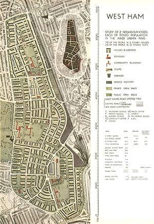
West Ham study of 2 neighbourhoods each of 8000 population in the inner Urban ring
Date d'édition : 1944
Carte
Etat : Good. WEST HAM PLAISTOW UPTON PARK.Planned postwar redevelopment.ABERCROMBIE 1944 map. Vintage colour town planning map; Patrick Abercrombie (1944). 30.5 x 21.0cm, 12 x 8.25 inches. Condition: Good. The map has been printed up to the edges of the paper, as issued, hence there are no margins or borders; The image shown may have been taken from a different example of this map than that which is offered for sale. The map you will receive is in good condition but there may be minor variations in the condition from that shown in the image. There are images and/or text printed on the reverse side of the picture. In some cases this may be visible on the picture itself or around the margin of the picture.
-
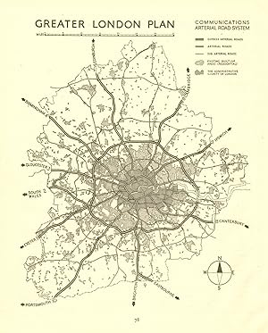
Etat : Good. GREATER LONDON. Proposed motorways arterial ring roads M25.ABERCROMBIE 1944 map. Vintage town planning map; Patrick Abercrombie (1944). 27.0 x 21.5cm, 10.5 x 8.5 inches. Condition: Good. Verso text quite apparent; The image shown may have been taken from a different example of this map than that which is offered for sale. The map you will receive is in good condition but there may be minor variations in the condition from that shown in the image. There are images and/or text printed on the reverse side of the picture. In some cases this may be visible on the picture itself or around the margin of the picture.
-
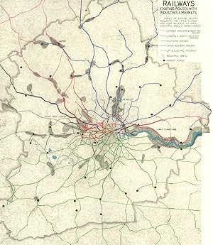
Etat : Good. GREATER LONDON. Railways routes. Industries Markets.ABERCROMBIE 1944 old map. Vintage colour town planning map; Patrick Abercrombie (1944). 22.0 x 19.0cm, 8.75 x 7.5 inches. Condition: Good. The image shown may have been taken from a different example of this map than that which is offered for sale. The map you will receive is in good condition but there may be minor variations in the condition from that shown in the image. There are images and/or text printed on the reverse side of the picture. In some cases this may be visible on the picture itself or around the margin of the picture.
-
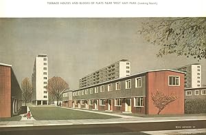
Terrace Houses and Blocks of flats near West Ham Park (Looking North)
Date d'édition : 1944
Art / Affiche / Gravure
Etat : Good. WEST HAM PARK. Proposed Terrace Houses & Blocks of flats. ABERCROMBIE 1944. Vintage colour print; Patrick Abercrombie (1944). 20.0 x 30.5cm, 7.75 x 12 inches. Condition: Good. The print has been printed up to the edges of the paper, as issued, hence there are no margins or borders; The image shown may have been taken from a different example of this print than that which is offered for sale. The print you will receive is in good condition but there may be minor variations in the condition from that shown in the image. There are images and/or text printed on the reverse side of the picture. In some cases this may be visible on the picture itself or around the margin of the picture.
-
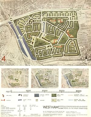
West Ham proposal for one neighbourhood of 12,000 people in the inner Urban ring
Date d'édition : 1944
Carte
Etat : Good. CANNING TOWN. Proposed post war redevelopment. ABERCROMBIE 1944 old map. Vintage colour town planning map; Patrick Abercrombie (1944). 30.0 x 23.5cm, 11.75 x 9.25 inches. Condition: Good. The map has been printed up to the edges of the paper, as issued, hence there are no margins or borders; The image shown may have been taken from a different example of this map than that which is offered for sale. The map you will receive is in good condition but there may be minor variations in the condition from that shown in the image. There are images and/or text printed on the reverse side of the picture. In some cases this may be visible on the picture itself or around the margin of the picture.
-
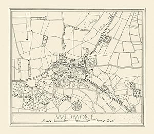
Etat : Good. Town plan of Wedmore by Patrick Abercrombie. Somerset 1930 old vintage map. Vintage map; Patrick Abercrombie (1930). 11.0 x 13.0cm, 4.5 x 5 inches. Condition: Good. There is nothing printed on the reverse side, which is plain.
-
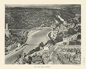
Etat : Good. The Avon Gorge at Bristol. Clifton Suspension Bridge. Sion Hill 1930 old print. Vintage print; Patrick Abercrombie (1930). 19.5 x 24.0cm, 7.5 x 9.5 inches. Condition: Good. There is nothing printed on the reverse side, which is plain.
-
The Doncaster Regional Planning scheme
Edité par Isha Books, 2013
ISBN 10 : 9332867259ISBN 13 : 9789332867253
Livre
Etat : New.
Plus de choix d'achat de la part d'autres vendeurs sur AbeBooks
Offres neuf ŕ partir de EUR 15,50
-
The London sprawl and Density of Development; County of London plan Extent of built up area, 1938
Date d'édition : 1943
Carte
Etat : Good. LONDON.Sprawl & Density of Development;plan Extent built up area,1938 1943 map. Vintage map; Abercrombie, Patrick (1943). 24.5 x 31.5cm, 9.75 x 12.25 inches. Condition: Good. The image shown may have been taken from a different example of this map than that which is offered for sale. The map you will receive is in good condition but there may be minor variations in the condition from that shown in the image. The map has been printed up to the edges of the paper, as issued, hence there are no margins or borders. There are images text around the image.
-
Etat : Good. GREATER LONDON. Road traffic densities in 1938. ABERCROMBIE 1944 old map. Vintage colour town planning map; Patrick Abercrombie (1944). 24.5 x 19.0cm, 9.75 x 7.5 inches. Condition: Good. The image shown may have been taken from a different example of this map than that which is offered for sale. The map you will receive is in good condition but there may be minor variations in the condition from that shown in the image. There are images and/or text printed on the reverse side of the picture. In some cases this may be visible on the picture itself or around the margin of the picture.
-
Etat : Good. GREATER LONDON PLAN. England & Wales road traffic density. ABERCROMBIE 1944 map. Vintage colour town planning map; Patrick Abercrombie (1944). 23.0 x 21.0cm, 9 x 8.25 inches. Condition: Good. The image shown may have been taken from a different example of this map than that which is offered for sale. The map you will receive is in good condition but there may be minor variations in the condition from that shown in the image. There are images and/or text printed on the reverse side of the picture. In some cases this may be visible on the picture itself or around the margin of the picture.
-
Town & Country Planning
Edité par Oxford University Press, 1943
Vendeur : World of Rare Books, Goring-by-Sea, SXW, Royaume-Uni
Evaluation du vendeur :

Etat : Good. 1943. Second Edition. 256 pages. No dust jacket. Grey cloth. Clean pages with mild tanning and foxing throughout. Tightly bound with faint thumb-marking throughout. Pencil inscription to front endpaper. Boards have light edgewear with corner crushing and light marking to boards. Notable tanning to board edges and spine, which has mild crushing to ends.
-
Liverpool Town Planning and Housing Exhibition, 1914 (Classic Reprint)
Edité par Forgotten Books, 2018
ISBN 10 : 0282090215ISBN 13 : 9780282090210
Livre impression ŕ la demande
Paperback. Etat : New. Print on Demand. Excerpt from Liverpool Town Planning and Housing Exhibition, 1914. About the Publisher, Forgotten Books publishes hundreds of thousands of rare and classic books. This book is a reproduction of an important historical work. Forgotten Books uses state-of-the-art technology to digitally reconstruct the work, preserving the original format whilst repairing imperfections present in the aged copy. In rare cases, an imperfection in the original, such as a blemish or missing page, may be replicated in our edition. We do, however, repair the vast majority of imperfections successfully; any imperfections that remain are intentionally left to preserve the state of such historical works. This text has been digitally restored from a historical edition. Some errors may persist, however we consider it worth publishing due to the work's historical value. The digital edition of all books may be viewed on our website before purchase. print-on-demand item.
-

The Doncaster Regional Planning Scheme
Edité par LEGARE STREET PR, 2022
ISBN 10 : 1017723400ISBN 13 : 9781017723403
Livre impression ŕ la demande
PAP. Etat : New. New Book. Shipped from UK. THIS BOOK IS PRINTED ON DEMAND. Established seller since 2000.
Plus de choix d'achat de la part d'autres vendeurs sur AbeBooks
Offres neuf ŕ partir de EUR 22,53
-
Dublin of the Future
Edité par LEGARE STREET PR, 2022
ISBN 10 : 1016232403ISBN 13 : 9781016232401
Livre impression ŕ la demande
PAP. Etat : New. New Book. Shipped from UK. THIS BOOK IS PRINTED ON DEMAND. Established seller since 2000.
Plus de choix d'achat de la part d'autres vendeurs sur AbeBooks
Offres neuf ŕ partir de EUR 22,61
![Image du vendeur pour [Hatfield] mis en vente par Antiqua Print Gallery](https://pictures.abebooks.com/inventory/md/md31106594874.jpg)