
Montant total (1 article articles) :
Destination de la commande :

BACON, G EORGE W ASHINGTON (5 résultats)
Passer aux résultats principaux de la recherche
Type d'article
- Tous les types d'articles
- Livres
- Magazines & Périodiques
- Bandes dessinées
- Partitions de musique
- Art, Affiches et Gravures
- Photographies
- Cartes (5)
-
Manuscrits &
Papiers anciens
Etat
- Tous
- Neuf
- Ancien ou d'occasion
Reliure
- Toutes
- Couverture rigide (1)
- Couverture souple
Particularités
- Edition originale
- Signé
- Jaquette
- Avec images
- Sans impression ŕ la demande
Pays
Evaluation du vendeur
-
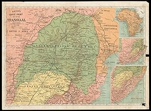
Bacon's large-print map of the Transvaal
Edité par G. W. Bacon & Co., Ltd., 127 Strand, [c1899]., London,, 1899
Vendeur : Daniel Crouch Rare Books Ltd, London, Royaume-Uni
Membre d'association : ABA ILAB PBFA
Evaluation du vendeur :

Carte
Bacon's rare map of the Transvaal Lithograph map in full-colour, with three inset maps, laid on cardboard, two small holes on right border with minimal effect on image. This rare map of the Transvaal, or the South African Republic, was produced and sold to the general public in London, at a time when the British Empire was approaching the pinnacle of its global influence. Made in 1899, it displays the southern African states on the verge of the Second Boer Wars, which would see the Transvaal transformed from an independent republic to a British possession. Despite its nominal focus on the South African Republic, the map predictably gives special prominence to the British colonies, represented in pink. The same is true of the inset maps along the right border: Cape Colony is labelled in the largest script on the map of Africa, and similarly, the map that claims to show Orange Free State is actually dominated by the British territory. The map displays the typical geographical features of labelled towns and cities, relief expressed by hachures, and a few small lakes. Alongside these, it also records the communications networks that spanned the Portuguese, British and independent territories, namely the railway system. Under the influence of the European powers, the rail network had expanded throughout the latter half of the nineteenth century. The swiftness of this expansion is evidenced by Johannesburg in particular: even though the city had only just become significant in the mid-1880s after its spectacular gold-rush, it is shown here at convergence of several major railway lines. The map was produced by the American mapmaker and publisher, George Bacon, who had made his name in the late nineteenth century by producing maps of London. His work was designed for popular consumption, printed in bold colour and with large print. During the 1890s, he produced a series of maps of the African territories, including Cape Colony and Orange Free State, examples of which are far more prevalent than his map of the Transvaal. By contrast, this map is particularly rare on the market, and we have not been able to trace another example appearing for sale.
-
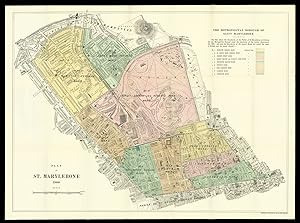
The Metropolitan Borough of St Marylebone
Edité par G.W. Bacon & Co. Ltd., 127, Strand,, London,, 1900
Vendeur : Daniel Crouch Rare Books Ltd, London, Royaume-Uni
Membre d'association : ABA ILAB PBFA
Evaluation du vendeur :
Carte
Victorian Marylebone Lithographed plan with contemporary hand-colour in full, laid down on linen and folding into original publisher's red cloth covers, decorated in blind, lettered in gilt. Detailed plan of Marylebone at the end of the nineteenth century. Each ward of the parish is highlighted and named with the western and eastern divisions outlined in red and green respectively. To the right is a list of the wards and their respective colouring. The plan highly detailed and shows, churches, schools, hospitals, clubs, theatres, tube stations, parks, squares, police stations, and notable houses. Of particular note is site of Lord's Cricket Ground and the Zoological Gardens. Scale: 9 inches to 1 statue mile. Rare: only one institutional example known, at the BL bound in an atlas Possibly in BL C.44.d.72.
-
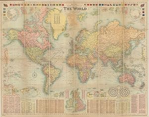
Bacon's New Chart of the World.
Edité par Manchester G.W. Bacon & Co. Ltd Royal London Buildings Deansgate c., 1906
Vendeur : Robert Frew Ltd. ABA ILAB, London, Royaume-Uni
Membre d'association : ABA ILAB PBFA
Evaluation du vendeur :

Carte
Original large colour-printed chart of the world on Mercator's projection (c. 96 x 120 cm overall), dissected into 24 sections and mounted onto linen, the territories of the British Empire marked in pink/red. Folding between publisher's original burgundy cloth covers (25 x 21 cm) with title in gilt to upper cover, marbled endpapers. A notably clean copy, excellent in the original publisher's cloth. A wealth of detail is recorded on the chart, both in the mapped areas and to the inset panels: - 46 flag illustrations to the upper edge - 18 maps of mostly port cities scattered across the chart including New York, San Francisco, Wellington, Tokyo, Singapore, Hong Kong and Bombay - a larger inset map of the British Isles to the lower margin - polar hemisphere maps to the upper corners - panels of text to the lower margin including a list of British Steamship routes, a gazetteer of towns and a list of territories in the British Empire - a panel of text listing the chief geographical discoveries to date, culminating in Peary reaching 87 6 N.lat in 1906. On the chart itself numerous details are recorded such as transcontinental railways, steamship routes, altitudes, depth soundings and ocean currents. No publish date appears on the chart. However, as mentioned before, the list of geographical discoveries goes up to 1906. Further to this, Robert Peary's journey to the North Pole is noted and dated 1906 on the Northern Polar map at the upper left corner whereas on later issues his 1909 expedition is noted. We have also seen examples with Mikkelsen's exploration of the Beaufort Sea in 1907 listed.
-

Map of Kensington and neighbourhood. Issued by Henry Lovibond and Son, Cannon Brewery, North End, Fulham, S.W.
Edité par Bacon's Map Establishment, 127 Strand,, London,, 1880
Vendeur : Daniel Crouch Rare Books Ltd, London, Royaume-Uni
Membre d'association : ABA ILAB PBFA
Evaluation du vendeur :
Carte
Hops, reformation, turkeys, carp, and beer, came into England all in one year Lithograph map with original hand colouring, dissected and laid on linen, folding into red cloth covers, lettered in gilt, pricelist and instructions labels on pastedowns, upper board detached. George Washington Bacon (1830-1922) was an American publisher working in Britain. His first business failed and he declared bankruptcy in 1867, but reopened on the Strand in 1870 and built his house into one of the most successful in London. The map of Kensington spans from Paddington to the north and Fulham to the south, and Hammersmith to the west and Green Park to the east. It prominently shows the Henry Lovibond & Son Cannon Brewery on the Lillie Road highlighted with red circles radiating from it in half mile increments, with the first being a quarter mile in distance. Henry Lovibond (c.1840-1910) was a brewer from Clerkenwell who acquired 'The Hermitage' villa and the remnants of its park on the corner of Lillie and North End Roads in 1867, and in the same year he built his Cannon's brewery there. Kensington was already an affluent borough after substantial redevelopment in the early nineteenth century, but in recent decades it had become a cultural centre as well. The Great Exhibition took place in Hyde Park in 1851, and the cultural complex known as Albertopolis began to form: the South Kensington Museum & School (now the Victoria & Albert Museum) opened in 1857, the Natural History Museum in 1881, and in 1881, and the Royal Albert Hall in 1871. Pearson, Lynn, 'Towers of Strength: Brewery architecture at home and abroad.' 25 February 2006.
-
[Pair of maps of India] North India [and] South India.
Edité par G.W. Bacon & Co., 127 The Strand, [c1900]., London,, 1900
Vendeur : Daniel Crouch Rare Books Ltd, London, Royaume-Uni
Membre d'association : ABA ILAB PBFA
Evaluation du vendeur :
Carte
A pair of large London Missionary Society Maps of India Pair of lithograph maps on linen, each map on two sheets joined. Rare pair of large wall maps depicting North and South India, Tibet, and Sri Lanka. All major cities are marked together the London Missionary Society's (L.M.S.) stations. Topographical features include rivers, and mountains. The text to the foot of each map implies the main role of these maps was to provide a survey of the L.M.S. stations in India. The cloth cloth loops at the top of each map, show that they were intended to be hung on a wall, of most probably a classroom or an office of the L.M.S. George Washington Bacon (1830-1922) was an American publisher working in Britain. His first business failed and he declared bankruptcy in 1867, but reopened on the Strand in 1870 and built his house into one of the most successful in London. In 1893 it was doing well enough to acquire the stock of James Wyld. He retired as managing director of the business in 1912, but remained director until his death in 1922. North India scale: 2 inches to 50 statute miles. South India scale: 3 inches to 50 statute miles. (north India) 1110 by 1500mm. (43.75 by 59 inches); (south India).
![Image du vendeur pour [Pair of maps of India] North India [and] South India. mis en vente par Daniel Crouch Rare Books Ltd](https://pictures.abebooks.com/inventory/md/md30793851681.jpg)