Montant total (1 article articles) :
Destination de la commande :

BACON, GEORGE WASHINGTON (Plus de 1 400 résultats)
Passer aux résultats principaux de la recherche
Type d'article
- Tous les types d'articles
- Livres (138)
- Magazines & Périodiques
- Bandes dessinées
- Partitions de musique
- Art, Affiches et Gravures (12)
- Photographies
- Cartes (1 314)
-
Manuscrits &
Papiers anciens
Etat
Reliure
Particularités
Livraison gratuite
Pays
Evaluation du vendeur
-
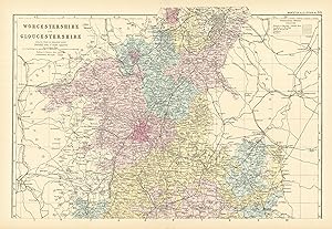
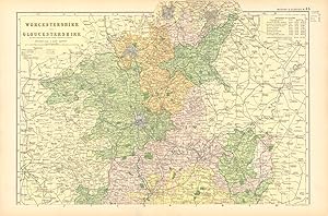
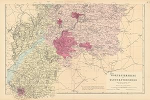
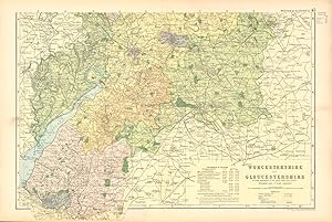
Etat : Good. WORCESTERSHIRE & GLOUCESTERSHIRE (North) antique county map by GW BACON 1891. Colour Antique Lithograph Map; George W Bacon (1891). 34.0 x 49.0cm, 13.5 x 19.25 inches; this is a folding map. Condition: Good. However, please note: The image shown may have been taken from a different example of this map than that which is offered for sale. The map you will receive is in good condition but there may be minor variations in the condition from that shown in the image. There is nothing printed on the reverse side, which is plain.
-
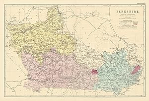
Etat : Good. BERKSHIRE antique county map by GW BACON 1891 old plan chart. Colour Antique Lithograph Map; George W Bacon (1891). 32.5 x 49.0cm, 12.75 x 19.25 inches; this is a folding map. Condition: Good. However, please note: The image shown may have been taken from a different example of this map than that which is offered for sale. The map you will receive is in good condition but there may be minor variations in the condition from that shown in the image. There is nothing printed on the reverse side, which is plain.
-
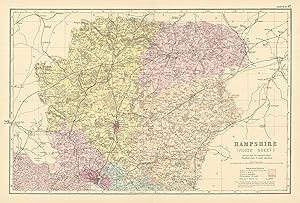
Etat : Good. HAMPSHIRE (North) antique county map by GW BACON 1891 old chart. Colour Antique Lithograph Map; George W Bacon (1891). 31.0 x 47.5cm, 12 x 18.5 inches; this is a folding map. Condition: Good. However, please note: The image shown may have been taken from a different example of this map than that which is offered for sale. The map you will receive is in good condition but there may be minor variations in the condition from that shown in the image. There is nothing printed on the reverse side, which is plain.
-
![Image du vendeur pour Cumberland & Westmorland [North Sheet] mis en vente par Antiqua Print Gallery](https://pictures.abebooks.com/inventory/md/md31713200561.jpg)
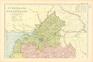
Etat : Good. CUMBRIA & WESTMORLAND (North sheet) antique county map by GW BACON 1898. Antique colour lithographic map; George W Bacon (1898). 32.5 x 48.5cm, 12.75 x 19.25 inches; this is a folding map. Condition: Good. The image shown may have been taken from a different example of this map than that which is offered for sale. The map you will receive is in good condition but there may be minor variations in the condition from that shown in the image. There is nothing printed on the reverse side, which is plain.
-
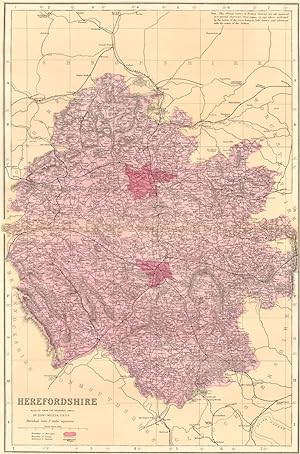
Etat : Good. HEREFORDSHIRE antique county map by GW BACON 1898 old plan chart. Antique colour lithographic map; George W Bacon (1898). 50.0 x 33.5cm, 19.75 x 13.25 inches; this is a folding map. Condition: Good. The image shown may have been taken from a different example of this map than that which is offered for sale. The map you will receive is in good condition but there may be minor variations in the condition from that shown in the image. There is nothing printed on the reverse side, which is plain.
-
Etat : Good. HAMPSHIRE (North) antique county map by GW BACON 1898 old chart. Antique colour lithographic map; George W Bacon (1898). 32.5 x 49.5cm, 12.75 x 19.5 inches; this is a folding map. Condition: Good. The image shown may have been taken from a different example of this map than that which is offered for sale. The map you will receive is in good condition but there may be minor variations in the condition from that shown in the image. There is nothing printed on the reverse side, which is plain.
-
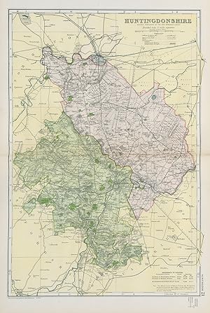
Etat : Good. HUNTINGDONSHIRE. Antique county map by GW BACON 1884 old chart. Colour Antique Lithograph Map; George W Bacon (1884). 46.0 x 31.5cm, 18 x 12.5 inches; this is a folding map. Condition: Good. The image shown may have been taken from a different example of this map than that which is offered for sale. The map you will receive is in good condition but there may be minor variations in the condition from that shown in the image. There is nothing printed on the reverse side, which is plain.
-
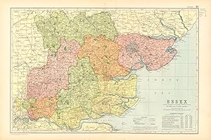
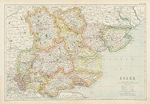
Etat : Good. ESSEX. Showing Parliamentary divisions, boroughs & parks. BACON 1904 old map. Antique colour lithographic map; GW Bacon (1904). 31.5 x 48.0cm, 12.5 x 18.75 inches; this is a folding map. Condition: Good. The image shown may have been taken from a different example of this map than that which is offered for sale. The map you will receive is in good condition but there may be minor variations in the condition from that shown in the image. There is nothing printed on the reverse side, which is plain.
-
Etat : Good. SHROPSHIRE (NORTH). Showing Parliamentary divisions & parks. BACON 1904 map. Antique colour lithographic map; GW Bacon (1904). 32.0 x 47.5cm, 12.5 x 18.75 inches; this is a folding map. Condition: Good. The image shown may have been taken from a different example of this map than that which is offered for sale. The map you will receive is in good condition but there may be minor variations in the condition from that shown in the image. There is nothing printed on the reverse side, which is plain.
-
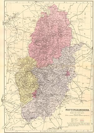
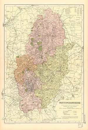
Etat : Good. NOTTINGHAMSHIRE. Antique county map by GW BACON 1884 old chart. Colour Antique Lithograph Map; George W Bacon (1884). 46.5 x 33.0cm, 18.25 x 13 inches; this is a folding map. Condition: Good. The image shown may have been taken from a different example of this map than that which is offered for sale. The map you will receive is in good condition but there may be minor variations in the condition from that shown in the image. There is nothing printed on the reverse side, which is plain.
-
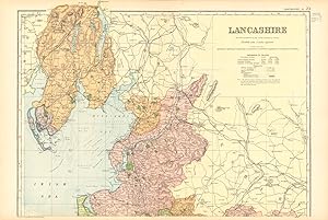
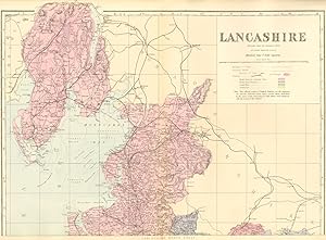
Etat : Good. LANCASHIRE (NORTH). Showing Parliamentary divisions & parks. BACON 1904 map. Antique colour lithographic map; GW Bacon (1904). 33.5 x 48.5cm, 13.25 x 19 inches; this is a folding map. Condition: Good. The image shown may have been taken from a different example of this map than that which is offered for sale. The map you will receive is in good condition but there may be minor variations in the condition from that shown in the image. There is nothing printed on the reverse side, which is plain.
-
Etat : Good. LANCASHIRE (SOUTH). Showing Parliamentary divisions & parks. BACON 1904 map. Antique colour lithographic map; GW Bacon (1904). 34.0 x 48.5cm, 13.25 x 19 inches; this is a folding map. Condition: Good. The image shown may have been taken from a different example of this map than that which is offered for sale. The map you will receive is in good condition but there may be minor variations in the condition from that shown in the image. There is nothing printed on the reverse side, which is plain.
-
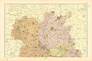
Etat : Good. WORCESTERSHIRE AND GLOUCESTERSHIRE NORTH. Parliamentary divisions.BACON 1904 map. Antique colour lithographic map; GW Bacon (1904). 32.5 x 48.5cm, 12.75 x 19.25 inches; this is a folding map. Condition: Good. The image shown may have been taken from a different example of this map than that which is offered for sale. The map you will receive is in good condition but there may be minor variations in the condition from that shown in the image. There is nothing printed on the reverse side, which is plain.
-
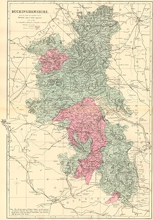
Etat : Good. BUCKINGHAMSHIRE. Antique county map by GW BACON 1884 old chart. Colour Antique Lithograph Map; George W Bacon (1884). 46.0 x 32.0cm, 18 x 12.5 inches; this is a folding map. Condition: Good. The image shown may have been taken from a different example of this map than that which is offered for sale. The map you will receive is in good condition but there may be minor variations in the condition from that shown in the image. There is nothing printed on the reverse side, which is plain.
-
Etat : Good. HEREFORDSHIRE. Antique county map by GW BACON 1884 old plan chart. Colour Antique Lithograph Map; George W Bacon (1884). 47.0 x 31.0cm, 18.5 x 12.25 inches; this is a folding map. Condition: Good. The image shown may have been taken from a different example of this map than that which is offered for sale. The map you will receive is in good condition but there may be minor variations in the condition from that shown in the image. There is nothing printed on the reverse side, which is plain.
-
Etat : Fair. HAMPSHIRE NORTH Parliamentary constituencies railways divisions BACON 1900 map. Antique map with original colour; George W Bacon (1900). 33.0 x 50.0cm, 13 x 19.5 inches; this is a folding map. Condition: Fair: Blemish; Some paper loss adjacent to centrefold; the sheet has been rebacked. Light soiling. Indistinct public library stamp across the lower right hand border. See scan. . There is nothing printed on the reverse side, which is plain.
-
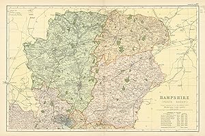
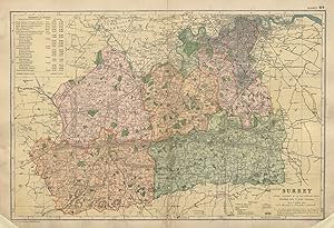
Etat : Fair. SURREY County map Parliamentary constituencies railways divisions BACON 1900. Antique map with original colour; George W Bacon (1900). 33.0 x 49.0cm, 13 x 19.25 inches; this is a folding map. Condition: Fair: Blemishes; Some paper loss to corners and adjacent to centrefold; the sheet has been rebacked. Marginal tears. Light soiling. Indistinct public library stamp across the lower right hand border. See scan. . There is nothing printed on the reverse side, which is plain.
-
Etat : Good. WORCESTERSHIRE & GLOUCESTERSHIRE (South). Antique county map by GW BACON 1884. Colour Antique Lithograph Map; George W Bacon (1884). 33.5 x 47.5cm, 13.25 x 18.5 inches; this is a folding map. Condition: Good. The image shown may have been taken from a different example of this map than that which is offered for sale. The map you will receive is in good condition but there may be minor variations in the condition from that shown in the image. There is nothing printed on the reverse side, which is plain.
-
Etat : Good. CUMBERLAND (NORTH). Showing Parliamentary divisions & parks. BACON 1904 map. Antique colour lithographic map; GW Bacon (1904). 31.5 x 47.5cm, 12.25 x 18.75 inches; this is a folding map. Condition: Good. The image shown may have been taken from a different example of this map than that which is offered for sale. The map you will receive is in good condition but there may be minor variations in the condition from that shown in the image. There is nothing printed on the reverse side, which is plain.
-
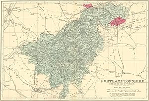
Etat : Good. NORTHAMPTONSHIRE (North). Antique county map by GW BACON 1884 old. Colour Antique Lithograph Map; George W Bacon (1884). 31.5 x 46.5cm, 12.25 x 18.25 inches; this is a folding map. Condition: Good. The image shown may have been taken from a different example of this map than that which is offered for sale. The map you will receive is in good condition but there may be minor variations in the condition from that shown in the image. There is nothing printed on the reverse side, which is plain.
-
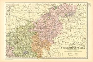
Etat : Good. NORTHAMPTONSHIRE (NORTH). Constituencies, boroughs & parks. BACON 1904 old map. Antique colour lithographic map; GW Bacon (1904). 32.5 x 49.0cm, 12.75 x 19.25 inches; this is a folding map. Condition: Good. The image shown may have been taken from a different example of this map than that which is offered for sale. The map you will receive is in good condition but there may be minor variations in the condition from that shown in the image. There is nothing printed on the reverse side, which is plain.
-
Etat : Good. WORCESTERSHIRE AND GLOUCESTERSHIRE SOUTH. Parliamentary divisions.BACON 1904 map. Antique colour lithographic map; GW Bacon (1904). 33.0 x 48.5cm, 13 x 19.25 inches; this is a folding map. Condition: Good. The image shown may have been taken from a different example of this map than that which is offered for sale. The map you will receive is in good condition but there may be minor variations in the condition from that shown in the image. There is nothing printed on the reverse side, which is plain.
-
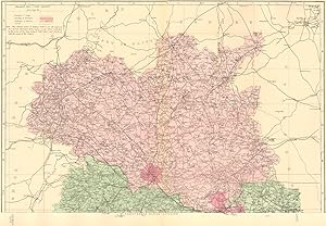
Etat : Good. LANCASHIRE (North sheet). Antique county map by GW BACON 1884 old. Colour Antique Lithograph Map; George W Bacon (1884). 33.5 x 46.0cm, 13.25 x 18 inches; this is a folding map. Condition: Good. The image shown may have been taken from a different example of this map than that which is offered for sale. The map you will receive is in good condition but there may be minor variations in the condition from that shown in the image. There is nothing printed on the reverse side, which is plain.
-
Etat : Good. SHROPSHIRE (North). Antique county map by GW BACON 1884 old chart. Colour Antique Lithograph Map; George W Bacon (1884). 32.0 x 46.5cm, 12.5 x 18.25 inches; this is a folding map. Condition: Good. The image shown may have been taken from a different example of this map than that which is offered for sale. The map you will receive is in good condition but there may be minor variations in the condition from that shown in the image. There is nothing printed on the reverse side, which is plain.
-
Etat : Good. NOTTINGHAMSHIRE. Showing Parliamentary divisions,boroughs & parks.BACON 1904 map. Antique colour lithographic map; GW Bacon (1904). 49.0 x 33.5cm, 19.25 x 13.25 inches; this is a folding map. Condition: Good. The image shown may have been taken from a different example of this map than that which is offered for sale. The map you will receive is in good condition but there may be minor variations in the condition from that shown in the image. There is nothing printed on the reverse side, which is plain.
-
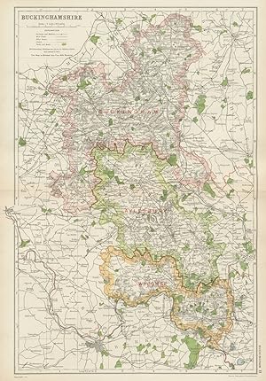
Etat : Good. BUCKINGHAMSHIRE. Showing Parliamentary divisions,boroughs & parks.BACON 1934 map. Vintage colour lithographic map; GW Bacon (1934). 47.0 x 33.0cm, 18.5 x 13 inches; this is a folding map. Condition: Good. There is nothing printed on the reverse side, which is plain.
-
Etat : Fair. ESSEX. Showing Parliamentary divisions, boroughs & parks. BACON 1934 old map. Vintage colour lithographic map; GW Bacon (1934). 33.0 x 47.0cm, 13 x 18.5 inches; this is a folding map. Condition: Fair: Repaired tear in bottom margin extending c.3cm inside the border of the map; paper damage. There is nothing printed on the reverse side, which is plain.
-
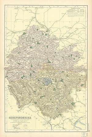
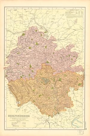
Etat : Good. HEREFORDSHIRE. Showing Parliamentary divisions, boroughs & parks. BACON 1904 map. Antique colour lithographic map; GW Bacon (1904). 49.0 x 32.0cm, 19.25 x 12.5 inches; this is a folding map. Condition: Good. The image shown may have been taken from a different example of this map than that which is offered for sale. The map you will receive is in good condition but there may be minor variations in the condition from that shown in the image. There is nothing printed on the reverse side, which is plain.
-
Etat : Good. LANCASHIRE (NORTH) . Showing Parliamentary divisions & parks. BACON 1900 map. Antique colour map; GW Bacon (1900). 34.0 x 49.0cm, 13.25 x 19.25 inches; this is a folding map. Condition: Good. The image shown may have been taken from a different example of this map than that which is offered for sale. The map you will receive is in good condition but there may be minor variations in the condition from that shown in the image which may include some light spotting. There is nothing printed on the reverse side, which is plain.
-
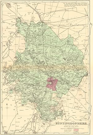
Etat : Good. HUNTINGDONSHIRE.Showing Parliamentary divisions,boroughs & parks.BACON 1900 map. Antique colour map; GW Bacon (1900). 48.0 x 31.5cm, 19 x 12.5 inches; this is a folding map. Condition: Good. The image shown may have been taken from a different example of this map than that which is offered for sale. The map you will receive is in good condition but there may be minor variations in the condition from that shown in the image which may include some light spotting. There is nothing printed on the reverse side, which is plain.
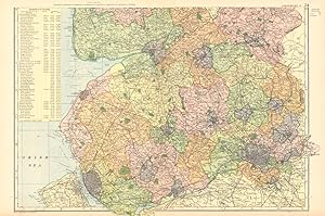

![Image du vendeur pour Lancashire [north sheet] mis en vente par Antiqua Print Gallery](https://pictures.abebooks.com/inventory/md/md31103394521.jpg)