Montant total (1 article articles) :
Destination de la commande :

BACON G W (739 résultats)
Passer aux résultats principaux de la recherche
Type d'article
- Tous les types d'articles
- Livres (291)
- Magazines & Périodiques (2)
- Bandes dessinées
- Partitions de musique
- Art, Affiches et Gravures
- Photographies
- Cartes (446)
-
Manuscrits &
Papiers anciens
Etat
Reliure
Particularités
Livraison gratuite
Pays
Evaluation du vendeur
-

Advancement of Learning
Edité par Everyman Paperbacks, 1991
ISBN 10 : 046011719XISBN 13 : 9780460117197
Livre
Paperback. Etat : Good. Connecting readers with great books since 1972! Used textbooks may not include companion materials such as access codes, etc. May have some wear or writing/highlighting. We ship orders daily and Customer Service is our top priority!.
Plus de choix d'achat de la part d'autres vendeurs sur AbeBooks
Offres d'occasion ŕ partir de EUR 7,26
-
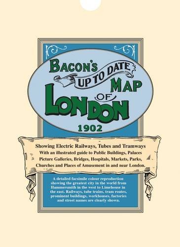
Bacon's Up-to-Date Map of London 1902
Edité par Old House Books
ISBN 10 : 1873590237ISBN 13 : 9781873590232
Livre
Paperback. Etat : Very Good. The book has been read, but is in excellent condition. Pages are intact and not marred by notes or highlighting. The spine remains undamaged.
Plus de choix d'achat de la part d'autres vendeurs sur AbeBooks
Offres d'occasion ŕ partir de EUR 3,60
-
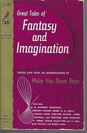
Great Tales of Fantasy and Imagination (aka The Moonlight Traveler)
Edité par Montreal: Pocket Books Cardinal Edition # C-156 2nd Printing, 1955
Edition originale
Mass Market Paperback. Etat : Very Good. Paul Bacon (front cover) (illustrateur). ----------vintage paperback, Canadian printing. A 485-page anthology with a self-explanatory title. Spine creases, edgewear, a VG copy.
-
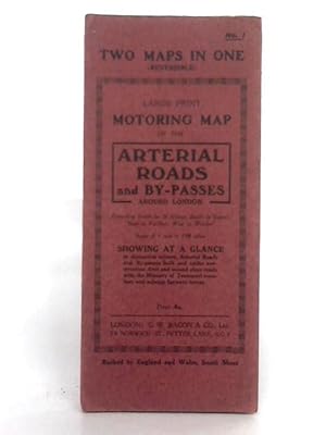
Reversible Large Print Motoring Map No.1: Arterial Roads and England & Wales: South Sheet
Edité par G.W. Bacon & Co. Ltd, 1111
Vendeur : World of Rare Books, Goring-by-Sea, SXW, Royaume-Uni
Evaluation du vendeur :

Etat : Fair. No Edition Remarks. Unpaginated. Red paper cover. Colour illustrated reversible map. Number 1: Arterial Roads and By-Passes, 1 inch to 1.08 miles; and England & Wales, South Sheet, 8 miles to 1 inch. Map is lightly tanned with some mild rubbed marks overall. Scuffing along folds, with some heavier tanning. Some moderate tears to folds along edges. Paper cover has mild edge wear with scuffing to edges and creasing. Mild rubbing to surfaces with curling to corners.
-
The Advancement of Learning
Edité par Heron Books by arrangement with
Vendeur : Goldstone Rare Books, Llandybie, CARMS, Royaume-Uni
Evaluation du vendeur :
Hardcover. Etat : Good. The cover is clear of stains and marking. The hinges are in good condition. Photograph available on request.
-
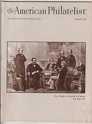
The American Philatelist September 1978; Volume 92, No. 9 (Whole No. 932)
Edité par American Philatelic Society, Inc, State College, PA, 1978
Magazine / Périodique
Soft Cover, Staple-bound. Etat : Very Good. No Jacket. 8˝"x11"; pages 817 to 912; The American Philatelist, the Journal of the American Philatelic Society published monthly, each edition includes a variety of articles written by some of the philatelic community's most respected authors. Please check the images with this listing for the Table of Contents of articles in this issue. The binding and pages are clean, tight and square. There is no underlining, highlighting or margin notes. However, there is some yellowing of the page edges due to age. It is a used copy with normal reading wear. If you order more than one book, I will combine the books in order to reduce postage costs. If you have any questions, contact me before ordering for details. This issue contains the following articles: "Junior American Philatelist" (specialized stamp collections and collectors) by Kathryn J. Johnson; "Postal History News" (postally used covers) by Ernst M. Cohn; "The 1938 Presidential Series: To the Victor Belong the Spoils" (The 7 cent Andrew Jackson stamp} by David K. Lindo; "Free Franks of President Lincoln and His Cabinet" by Theodore A. Stevens; "Leominster, Massachusetts Adhesive Labels" (Charles H. Colburn postmaster used adhesive labels to indicate postage due 1850s,1860s and 1870s) by David L. Jarrett; "Uruguay Issue of 1860: The Sun of 180 Centesimos" by Fausto Diaz Paulos; "The Beginning of the American APO" by Richard W. Sackett; "U. S. Government Agency Use of Metered Postage: Part I General" by James H. Baker; "Orchids And/On Stamps" by Allen D. Kerr; "Taxes and Philately: The Stamp Collection, Its Disposition and Taxation" by Richard G. Baco; "Rounding-Out the 'Animas' Story" ((postal history cover from Animas, Colorado 1884) by George Phillips; "Whatever Happened to the Inter-Allied Games?" by Joe Schirmer; "Survey of Naval Cover Collecting" by William J. Luetge; "The President's Message: Audio Visual Volunteer Opportunities" (establishment of the Audio Visual Committee) by John E. Foxworth, Jr.; "Sales Talk" (APS sales circuits) by Gordon P. Wrenn; "Operation Stop Thief" (APS Stamp Theft Committee, Anyi-Burglary Check List) by Maryette B. Lane; "Chapter Notes" (APS activities of associate member groups) by Frank L. Sente; "Back in the Stacks" (APRL Borrowing Procedures) by Lois M. Evans.
-

Bacon's County Map Of Yorkshire
Edité par G W Bacon & Co, 1111
Vendeur : World of Rare Books, Goring-by-Sea, SXW, Royaume-Uni
Evaluation du vendeur :
Etat : Good. Unpaginated. Green pictorial paperback. Map is bright and clear with some light foxing and tanning. Slight creases to corners.
-
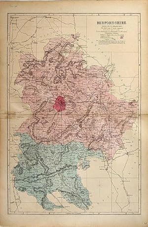
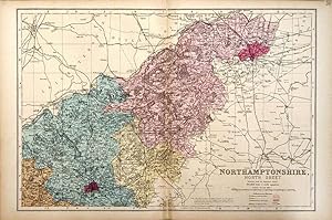
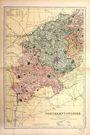
Single sheet. Large double page hand coloured map as issued with woods, parks, hills, roads and railways. The railway companies are named on each line. Slight surface damage along centrefold for 2/3 cm outside Beds boundary. Two short marginal tears repaired. 30 x 46 cm.
-
Single sheet. Large double page coloured map with woods, parks, hills, roads and railways. The railway companies are named on each line. Has a strengthened or repaired centrefold and the join can be seen. 30 x 46 cm.
-
Single sheet. Large double page hand coloured map as issued with woods, parks, hills, roads and railways. The railway companies are named on each line. Has been repaired on the front with transparent water based tape on LHS at the centrefold, just covering the border. 31 x 46 cm.
-

Single sheet. Large double page hand coloured map as issued with woods, parks, hills, roads and railways. The railway companies are named on each line. Has been repaired on the front with transparent water based tape at the LHS of the centrefold, for 2 or 3 cm. 31 x 46 cm.
-

Single sheet. Large double page coloured map with woods, parks, hills, roads and railways. The railway companies are named on each line. Has a strengthened or repaired centrefold and the join can be seen. 31 x 46 cm.
-
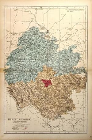
Single sheet. Large double page hand coloured map as issued with woods, parks, hills, roads and railways. The railway companies are named on each line. Has been repaired on the front with transparent water based tape at the LHS of the centrefold, for 2 or 3 cm. 30 x 47 cm.
-
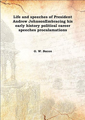
Life and speeches of President Andrew JohnsonEmbracing his early history political career speeches procalamations 1865 [Hardcover]
Edité par Facsimile Publisher, 2015
ISBN 10 : 9333384707ISBN 13 : 9789333384704
Livre
Etat : New. pp. 112.
Plus de choix d'achat de la part d'autres vendeurs sur AbeBooks
Offres neuf ŕ partir de EUR 9,70
-
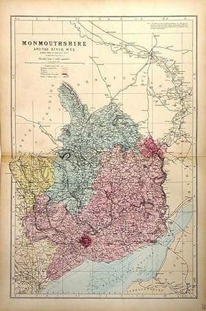
Single sheet. Large double page hand coloured map as issued with woods, parks, hills, roads and railways. The railway companies are named on each line. Has been repaired on the front with transparent water based tape on LHS at the centrefold. Otherwise a very nice copy. 31 x 47 cm.
-

Soft cover. Etat : Good. 1901. Europe/England. 18 pages of text and fold out map. Wear along edges, but map is good. May have been ex-library with red stamping on front "Pamphlet file" and black ink writing, "Description & Travel". Cover has man and woman with bicycles (no helmets, though :-) o&e 6/21.
-

Single sheet. Coloured map of Nova Scotia & Prince Edward Island with an inset of Newfoundland which says it shows the Southern boundary of the French fisheries, but this is invisible! It does show the landfall of the Trinity B submarine telegraph cable. 31 x 23 cm.
-

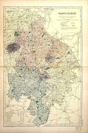
Single sheet. Large double page coloured map with woods, parks, hills, roads and railways. The railway companies are named on each line. A little foxing around edges. 46 x 31 cm.
-
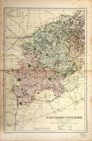
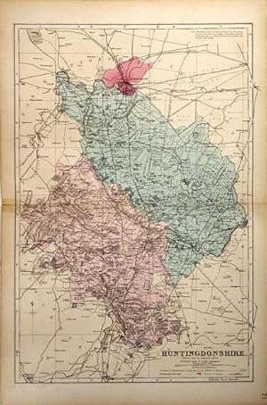
Single sheet. Large double page coloured map with woods, parks, hills, roads and railways. The railway companies are named on each line. Some foxing around edges but will look fine in a mount. 31 x 46 cm.
-
Single sheet. Large double page hand coloured map as issued with woods, parks, hills, roads and railways. The railway companies are named on each line. A very short repair on the front with transparent water based tape at the very foot of the centrefold and strengthening behind at top and bottom. 46 x 31 cm.
-
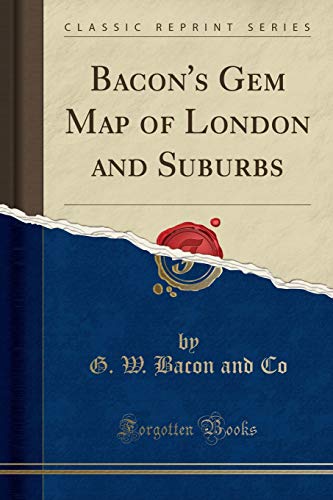
Bacon's Gem Map of London and Suburbs (Classic Reprint)
Edité par Forgotten Books, 2018
ISBN 10 : 1528403932ISBN 13 : 9781528403931
Livre
PAP. Etat : New. New Book. Shipped from UK. Established seller since 2000.
Plus de choix d'achat de la part d'autres vendeurs sur AbeBooks
Offres neuf ŕ partir de EUR 15,64
-
Etat : Very good+. No date circa 1934 Stiff board blue covers . Two maps in one reversible.
-

The Advancement of Learning
Edité par Paul Dry Books, 2000
ISBN 10 : 096649136XISBN 13 : 9780966491364
Livre
Etat : Good. Book is in good condition and may contain underlining or highlighting and minimal wear. The book can also include library labels. May not contain miscellaneous items (toys, dvds, etc). We offer 100% money back guarantee and fast customer support.
Plus de choix d'achat de la part d'autres vendeurs sur AbeBooks
Offres neuf ŕ partir de EUR 19,82
Offres d'occasion ŕ partir de EUR 16,06
Trouvez également Couverture souple
-
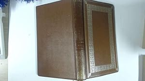
Hard Cover. Etat : Fine. No Jacket. Probably circa 1970. Produced by Heron Books, by arrangement with Dent who published the Everyman edition, edited and with an Introduction by G W Kitchin. 246pp, brown leatherette covered boards with gilt tooled decoration to the front and spine. Frontispiece portrait. Ribbon bookmark. A very clean, probably unread, copy. Includes an Index, a glossary and glossary of quotations.
-
Etat : Good. Ilus By C.W. Bacon. (illustrateur). Most items will be dispatched the same or the next working day. Small Tears to the Dust Jacket, Slipcase, or cover.
-

Single sheet. Nice full page map of Western Australia with an small inset of environs of Perth. 23 x 31 cm.
-

Single sheet. Nice full page map of South Australia with an inset plan of Adelaide. Good coverage of the region of lakes North of Eyres Peninsula. 23 x 31 cm.
-

Single sheet. Large double page coloured map with woods, parks, hills, roads and railways. The railway companies are named on each line. This map has been repaired or strengthened along the centrefold but this is not too obvious. 31 x 46 cm.
-

Single sheet. Large double page coloured map with woods, parks, hills, roads and railways. The railway companies are named on each line. A very nice copy. 46 x 31 cm.
-
Single sheet. Large double page coloured map with woods, parks, hills, roads and railways. The railway companies are named on each line. Has a strengthened or repaired centrefold. 31 x 46 cm.