Montant total (1 article articles) :
Destination de la commande :

BAGROW, LEO ED (38 résultats)
Passer aux résultats principaux de la recherche
Type d'article
- Tous les types d'articles
- Livres (38)
- Magazines & Périodiques
- Bandes dessinées
- Partitions de musique
- Art, Affiches et Gravures
- Photographies
- Cartes
-
Manuscrits &
Papiers anciens
Etat
- Tous
- Neuf
- Ancien ou d'occasion
Reliure
Particularités
- Edition originale (1)
- Signé
- Jaquette (3)
- Avec images (8)
- Sans impression ŕ la demande
Pays
Evaluation du vendeur
-

Imago Mundi: a Review of Early Cartography, VI
Edité par Kartografiska Sallskapet Stockholm, 1949
Vendeur : Aardvark Book Depot, Shorewood, WI, Etats-Unis
Evaluation du vendeur :

Softcover. Sewn softcover, 11.5x8.5", 110 pp., b&w plates and fold-out map reproductions. Light spine creasing, else VG, clean.
-
Imago Mundi: a Review of Early Cartography, IX
Edité par E. J. Brill, Leiden, 1952
Vendeur : Aardvark Book Depot, Shorewood, WI, Etats-Unis
Evaluation du vendeur :
Softcover. Sewn softcover, 11.5x8.5", 123 pp., b&w plates and fold-out map reproductions. Light spine creasing, else VG, clean.
-
295x215, 110 pp, worn and yellowing softcover, else in fair condition The book is in : English.
-
Imago Mundi. A Review of Early Cartography. VII.
Edité par Stockholm, Kartografiska sällskapet 1950. 1950, 1950
Vendeur : Rönnells Antikvariat AB, Stockholm, Sučde
Membre d'association : ILAB SVAF
Evaluation du vendeur :
30x22 cm. 116 pp. + plates and maps, some folding. Printed wrappers.
-
Imago Mundi. A Review of Early Cartography. IV.
Edité par Stockholm, Kartografiska sällskapet 1948. 1948, 1948
Vendeur : Rönnells Antikvariat AB, Stockholm, Sučde
Membre d'association : ILAB SVAF
Evaluation du vendeur :
30x22 cm. 100 pp. + plates and maps, some folding. Printed wrappers, small damage to upper cover, otherwise very good.
-
Imago Mundi. A Review of Early Cartography. V.
Edité par Stockholm, Kartografiska sällskapet 1948. 1948, 1948
Vendeur : Rönnells Antikvariat AB, Stockholm, Sučde
Membre d'association : ILAB SVAF
Evaluation du vendeur :
30x22 cm. 114 pp. + plates and maps, some folding. Printed wrappers.
-
Imago Mundi. A Review of Early Cartography. VI.
Edité par Stockholm, Kartografiska sällskapet 1949. 1949, 1949
Vendeur : Rönnells Antikvariat AB, Stockholm, Sučde
Membre d'association : ILAB SVAF
Evaluation du vendeur :
30x22 cm. 110 pp. + plates and maps, many folding. Printed wrappers.
-
Hardcover. Etat : Near Fine. volume five 30x22 cm. 114 pp. + plates and maps, some folding includes fold out of first maps of Delaware, maps of spain, baltic coast etc etc.
-
Hardcover. Etat : Near Fine. HARDCOVER VOLUME 1 84pp folding maps. Some articles in German , some in English. (not bi lingual) SCARCE.
-
Imago Mundi. A Review of Early Cartography. XX
Edité par N Israel-Amssterdam, 1966
Vendeur : Cambridge Rare Books, Cambridge, GLOUC, Royaume-Uni
Evaluation du vendeur :
PAPERBACK. Etat : GOOD. 1966. N Israel-Amssterdam. Softback. GOOD Black titles, cream card covers,
-
Imago Mundi. A Review of Early Cartography. 25
Edité par N Israel-Amsterdam, 1971
Vendeur : Cambridge Rare Books, Cambridge, GLOUC, Royaume-Uni
Evaluation du vendeur :
Softback. Etat : GOOD. 1971. N Israel-Amsterdam. Softback. GOOD Black titles, blue card covers,
-
Imago Mundi. A Periodical review of Early Cartography. III
Edité par N Israel-Amsterdam, 1970
Vendeur : Cambridge Rare Books, Cambridge, GLOUC, Royaume-Uni
Evaluation du vendeur :
Softback. Etat : GOOD. 1970. N Israel-Amsterdam. Softback. GOOD Black titles, grey card covers,
-
Imago Mundi. The Journal of the International Society for the History of Cartography. 33
Edité par Imago Mundi Ltd, 1981
Vendeur : Cambridge Rare Books, Cambridge, GLOUC, Royaume-Uni
Evaluation du vendeur :
Softback. Etat : GOOD. 1981. Imago Mundi Ltd. Softback. GOOD Black titles, blue stapled card covers,
-
Imago Mundi. A Review of Early Cartography.XXII.
Edité par N Israel-Amsterdam, 1968
Vendeur : Cambridge Rare Books, Cambridge, GLOUC, Royaume-Uni
Evaluation du vendeur :
PAPERBACK. Etat : GOOD. 1968. N Israel-Amsterdam. Softback. GOOD Black titles, grey card covers,
-
Imago Mundi. A Review of Early Cartography.XXIII
Edité par N Israel-Amssterdam, 1969
Vendeur : Cambridge Rare Books, Cambridge, GLOUC, Royaume-Uni
Evaluation du vendeur :
Softback. Etat : GOOD. 1969. N Israel-Amssterdam. Softback. GOOD Black titles, cream card covers,
-
Imago Mundi. A Periodical review of Early Cartography. Anno Dni MCMXXXVII
Edité par N Israel-Amsterdam, 1970
Vendeur : Cambridge Rare Books, Cambridge, GLOUC, Royaume-Uni
Evaluation du vendeur :
PAPERBACK. Etat : GOOD. 1970. N Israel-Amsterdam. Softback. GOOD Black titles, blue card covers,
-
Imago Mundi. A Review of Early Cartography.XVII
Edité par N Israel-Amssterdam, 1963
Vendeur : Cambridge Rare Books, Cambridge, GLOUC, Royaume-Uni
Evaluation du vendeur :
Softback. Etat : GOOD. 1963. N Israel-Amssterdam. Softback. GOOD Black titles, cream card covers,
-
Imago Mundi. A Review of Early Cartography.XXI
Edité par N Israel-Amssterdam, 1967
Vendeur : Cambridge Rare Books, Cambridge, GLOUC, Royaume-Uni
Evaluation du vendeur :
Softback. Etat : GOOD. 1967. N Israel-Amssterdam. Softback. GOOD Black titles, cream card covers,
-
Imago Mundi. A Review of Early Cartography.XVI
Edité par N Israel-Amsterdam, 1962
Vendeur : Cambridge Rare Books, Cambridge, GLOUC, Royaume-Uni
Evaluation du vendeur :
PAPERBACK. Etat : GOOD. 1962. N Israel-Amsterdam. Softback. GOOD Black titles, cream card covers,
-
Imago Mundi. A Review of Early Cartography. IV.
Edité par Stockholm, Kartografiska s?llskapet, 1947
Vendeur : Cambridge Rare Books, Cambridge, GLOUC, Royaume-Uni
Evaluation du vendeur :
Softback. Etat : GOOD. 1947. Stockholm, Kartografiska s?llskapet . Softback. GOOD Black titles, cream card covers, spine damaged, edgewear.
-
Imago Mundi. A Review of Early Cartography.XVIII
Edité par N Israel-Amsterdam, 1964
Vendeur : Cambridge Rare Books, Cambridge, GLOUC, Royaume-Uni
Evaluation du vendeur :
PAPERBACK. Etat : GOOD. 1964. N Israel-Amsterdam. Softback. GOOD Black titles, cream card covers,
-
Imago Mundi. A Review of Early Cartography. XXVI
Edité par N Israel-Amsterdam, 1972
Vendeur : Cambridge Rare Books, Cambridge, GLOUC, Royaume-Uni
Evaluation du vendeur :
Softback. Etat : GOOD. 1972. N Israel-Amsterdam. Softback. GOOD Black titles, blue card covers,
-
Imago Mundi. YEARBOOK OF OLD CARTOGRAPHY . Anno DNI MCMXXXV. I
Edité par N Israel-Amsterdam, 1974
Vendeur : Cambridge Rare Books, Cambridge, GLOUC, Royaume-Uni
Evaluation du vendeur :
Softback. Etat : GOOD. 1974. N Israel-Amsterdam. Softback. GOOD Black titles, cream card covers,
-
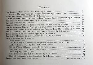
Hardcover. Etat : Near Fine. volume nine 123 pages. Illustrated. Articles on early Siberian maps, Boym's China map, Petrus Roselli, Ambrosius Thoms, Martin Faber, cosmographic loggia of the Vatican, Girolamo de Angelis, and more.
-
Hardcover. Etat : Near Fine. HARDCOVER.
-
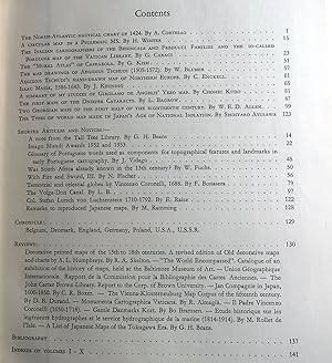
Hardcover. Etat : Near Fine. HARDCOVER Includes "The North-Atlantic nautical chart of 1424" by A. Cortesao; "The Italian cartographers of the Benincasa and Freducci Families and the so-called Borgiana map of the Vatican Library" by G. Caraci; and "The Types of world map made in Japan's Age of National Isolation" by Shintaro Ayusawa.
-
Imago Mundi. A Review of Early Cartography. Volume 4 [1947].
Edité par Stockholm, Kartografiska Sällskapet. 1947, 1947
Vendeur : Antiquariaat Schot, Hendrik-Ido-Ambacht, Pays-Bas
Evaluation du vendeur :
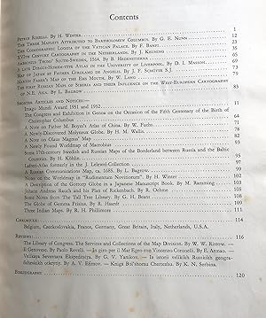
Original publisher's sewn cream paperback, black lettering spine & frontcover, 4to: [iv], 100pp., 10 articles, 9 shorter articles, richly illustrated [several folding maps in facsimile], chronicle, reviews, bibliography, list & references plates, table of contents. Very fine copy. CONTENTS: 1. Hiroshi Nakamura: Old Chinese World Map Preserved by the Koreans. 2. George H. Beans: Notes on the Cosmographia of Ptolemy, Bologna 1477. 3. H. Winter: On the Real- and the Pseudo-Pilestrina Maps and other Early Portuguese Maps in Munich. 4. H.R. Wagner: Additions to the Manuscript Atlases of Battista Agnese. 5. A. de Smet: Works of P. Pourbus 1583. 6. J. Keuning: The History of an Atlas Mercator-Hondius. 7. W. Voorbeijtel-cannenburg: A Dutch Chart that survived the Ages. 8. Leo Bagrow: Sparwenfeld's Map of Seberia. 9. Th. Arne: The Quandahar's Plan. 10. G. Kiss: The Correspondence of Continental Mapmakers of the 1770's and 80's. With a London Firm. Fine copy. Volume IV: Imago Mundi. A Review of Early Cartography.
-
Imago Mundi. A Review of Early Cartography. Volume 7 [1950].
Edité par Stockholm, Kartografiska Sällskapet. 1950, 1950
Vendeur : Antiquariaat Schot, Hendrik-Ido-Ambacht, Pays-Bas
Evaluation du vendeur :
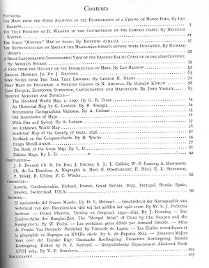
Original publisher's sewn cream paperback, black lettering spine & frontcover, 4to: 114pp., [2]pp., 12 articles, 8 shorter articles, richly illustrated [several folding maps], chronicle, reviews, bibliography, list & references plates, table of contents, advertisements. Very fine copy. CONTENTS: 1. W. Bonacker: The Egyptian 'Book of the Two Ways'. 2. G. Caraci: An unknown nautical chart of Grazioso Benincasa, 1468. 3. Leo Bagrow: Rüst's and Sporer's world maps. 4. H. Winter: A late Portolan chart at Madrid and late Portolan charts in general. 5. R. Almagia: The atlas of Pietro Coppo, 1520. 6. J. Keunig: Cornelis Anthonisz. 7. W. Horn: Sebastian Munster's map of Prussiaand the variants of it. 8. G. de reparaz: The topographical maps of Portugal and Spain in the 16th ventury. 9. W. Lang: The Augsburg travel guide of 1563 and the Erlinger road map of 1524. 10. R. Gallo: Gioan Francesco Camocio and his large map of Europe. 11. R.A. Skelton: Bishop Leslie's maps of Scotland. 12. K. Kitagawa: The map of Hokkaido of G. the Angelis. Fine copy. Volume VII: Imago Mundi. A Review of Early Cartography.
-
Imago Mundi. A Review of Early Cartography. Volume 6 [1949].
Edité par Stockholm, Kartografiska Sällskapet. 1949, 1949
Vendeur : Antiquariaat Schot, Hendrik-Ido-Ambacht, Pays-Bas
Evaluation du vendeur :
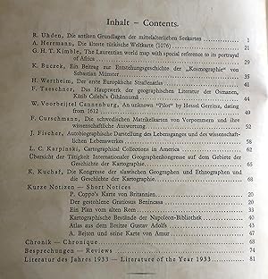
Original publisher's sewn cream paperback, black lettering spine & frontcover, 4to: [ij], 110pp., 11 articles, 12 shorter articles, richly illustrated [several folding maps in facsimile], chronicle, reviews, bibliography, list & references plates, table of contents. CONTENTS: 1. Henry R. Wagner: Marco Polo's Narrative becomes Propaganda to inspire Colon. 2. William Herbert Hobbs: Zeno and the Cartography of Greenland. 3. Heinrich Winter: Francisco Rodrigues' Atlas of c. a. 1513. 4. Werner Siegrist: A Map of Allgäu. 5. Rodolfo Gallo: Antonio Florian and his Mappemonde. 6. George Kish: Some Aspects of the Missionary Cartography of Japan during the Sixteenth Century. 7. J. Keuning: Hessel Gerritsz. 8. Harald Köhlin: Georg von Schwengeln and his Work, 1620-1645. 9. Ettore Rossi: A Turkish Map of the Nile River, about 1685. 10. Eila M. T. Campbell: An English Philosophico-Corographical Chart. 11. G. R. Crone: John Green. Notes on a neglected Eighteenth Century Geographer and Cartographer. Fine copy. Volume VI: Imago Mundi. A Review of Early Cartography.
-
Imago Mundi. A Review of Early Cartography. Volume 13 [1956].
Edité par s-Gravenhage, Mouton & Co. 1956, 1956
Vendeur : Antiquariaat Schot, Hendrik-Ido-Ambacht, Pays-Bas
Evaluation du vendeur :
Original publisher's sewn cream paperback, black lettering spine & frontcover, 4to: [x], 196pp., 15 articles, 10 shorter articles, richly illustrated [several folding maps in facsimile], chronicle, reviews, bibliography, list & references 27 plates, table of contents. Very fine copy. . Volume XIII: Imago Mundi. A Review of Early Cartography.