
Montant total (1 article articles) :
Destination de la commande :

BARTHOLOMEW, J AND SWANSTON, G H (3 résultats)
Passer aux résultats principaux de la recherche
Type d'article
- Tous les types d'articles
- Livres (3)
- Magazines & Périodiques
- Bandes dessinées
- Partitions de musique
- Art, Affiches et Gravures
- Photographies
- Cartes
-
Manuscrits &
Papiers anciens
Etat
- Tous
- Neuf
- Ancien ou d'occasion
Reliure
- Toutes
- Couverture rigide
- Couverture souple
Particularités
- Edition originale
- Signé
- Jaquette
- Avec images
- Sans impression ŕ la demande
Pays
Evaluation du vendeur
-
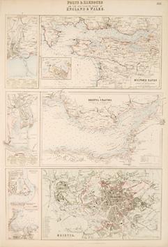
PORTS, & HARBOURS ON THE SOUTH-WEST COAST OF ENGLAND & WALES. XXX.
Edité par London, Edinburgh & Dublin 1860, 1860
Vendeur : Peter Harrington. ABA/ ILAB., London, Royaume-Uni
Membre d'association : ABA ILAB PBFA
Evaluation du vendeur :

Seven detailed maps on one sheet. The ports and harbours of Milford Haven (with inset of Pembroke Dock), Bristol Channel, Swansea, Cardiff, Newport Dock, Fishguard Bay, and a town plan of Bristol. Fullarton's Royal Illustrated Atlas of Modern Geography was the last highly decorative atlas published in England, and the maps are much sought after. Steel engraving. Original colour. Fine condition. Size: 30.5 x 42.5 cm.
-
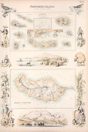
PORTUGUESE ISLANDS in the Atlantic Ocean. Plate 49.
Edité par Edinburgh. 1860, 1860
Vendeur : Peter Harrington. ABA/ ILAB., London, Royaume-Uni
Membre d'association : ABA ILAB PBFA
Evaluation du vendeur :
This beautiful plate contains two maps - the upper map shows the islands of the Azores, the lower map Madeira. Both maps are surrounded by vignettes and views of the Azores and Madeira. Fullarton's Royal Illustrated Atlas of Modern Geography was the last highly decorative atlas published in England, and the maps are much sought after. From The 'Royal Illustrated Atlas of Modern Geography' by Archibald Fullarton & Co. Size: 310 x 460 mm. Steel engraving. Original colour. Excellent condition.
-
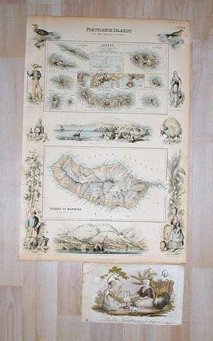
Portuguese Islands in the Atlantic Ocean: 2 Karten auf einem Blatt mit allen 10 azorischen Inseln sowie Madeira, umgeben von 10 Einzelansichten.
Edité par London, A. Fullarton & Co. 1850., 1850
Vendeur : Antiquariat Knöll, Lüneburg, Allemagne
Membre d'association : GIAQ ILAB VDA
Evaluation du vendeur :
Handkolorierte Stahlstichtafel aus: Royal Illustrated Atlas of Modern Geography, Plate 49. Größe: 47 x 31 cm (Folio). Zustand: Schwach gebräunt. Im linken Rand Druckspur von Rahmung. Rechte obere Ecke mit Einriß (kein Darstellungsverlust). Beigabe: 1 altkolor. Stich aus gleicher Zeit: Ländliche Beschäftigung auf Madeira (Stecher: Hössel, 11 x 19 cm).