Montant total (1 article articles) :
Destination de la commande :

BLAEU, W (191 résultats)
Passer aux résultats principaux de la recherche
Type d'article
- Tous les types d'articles
- Livres (124)
- Magazines & Périodiques
- Bandes dessinées
- Partitions de musique
- Art, Affiches et Gravures (15)
- Photographies
- Cartes (52)
-
Manuscrits &
Papiers anciens
Etat
- Tous
- Neuf
- Ancien ou d'occasion
Reliure
Particularités
- Edition originale (3)
- Signé
- Jaquette (2)
- Avec images (177)
- Sans impression ŕ la demande
Pays
Evaluation du vendeur
-
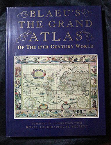
Blaeus the Grand Atlas of the 17th Century World
Edité par Studio Edns., 1997
ISBN 10 : 1858915880ISBN 13 : 9781858915883
Livre
Hardcover. Etat : Used; Good. **SHIPPED FROM UK** We believe you will be completely satisfied with our quick and reliable service. All orders are dispatched as swiftly as possible! Buy with confidence! Greener Books.
Plus de choix d'achat de la part d'autres vendeurs sur AbeBooks
Offres d'occasion ŕ partir de EUR 11,39
-
Deutschland vor drei Jahrhunderten. Seine Städte, Flüsse u. Wälder betrachtet. M. e. nachw. v. C. Broekema.
Edité par (Gütersloh) Bertelsmann (), 1971
Vendeur : Zentralantiquariat Leipzig GmbH, Leipzig, Allemagne
Membre d'association : BOEV
Evaluation du vendeur :

4°. M. zahlr. Ktn u. Abb. 300 S. OPp. m. OPp.-Schuber. Sprache: Deutsch.
-
Grand Atlas of the Seventeenth Century World
Edité par London, Studio, 1990
ISBN 10 : 1851704000ISBN 13 : 9781851704002
Livre
Befriedigend/Good: Durchschnittlich erhaltenes Buch bzw. Schutzumschlag mit Gebrauchsspuren, aber vollständigen Seiten. / Describes the average WORN book or dust jacket that has all the pages present.
Plus de choix d'achat de la part d'autres vendeurs sur AbeBooks
Offres d'occasion ŕ partir de EUR 20,83
-
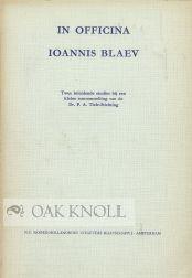
IN OFFICINA IOANNIS BLAEV
Edité par N.V. Noord-Hollandsche Uitgevers Maatschappij, Amsterdam, 1961
Vendeur : Oak Knoll Books, ABAA, ILAB, NEW CASTLE, DE, Etats-Unis
Membre d'association : ABAA ILAB
Evaluation du vendeur :
stiff paper wrappers. Blaeu, Ioannis (illustrateur). small 8vo. stiff paper wrappers. (iv), 51 pages. Twee inleidende studies bij een kleine tentoonstelling van de Dr. P.A. Tiele-Stichting. Information on this Dutch mapmaker. Some fading of covers.
-
Picardia, map, Blaeu anno 1660
Edité par Blaeu W.+J.,Atlases,Maps,Townboo
Vendeur : Hammelburger Antiquariat, Hammelburg, Allemagne
Evaluation du vendeur :

Hardcover. Etat : very good. Picardia, map, Blaeu anno 1660 Coppermap, edited by G Blaeu, ca. anno 1660, no text on verso, size of the leaf: 40 x 55 cm., little waterstained, foxed.
-
Aardenburg-Ysendijck, Zeeland, Blaeu anno 1640, townbooks
Edité par Blaeu W.+J.,Atlases,Maps,Townboo
Vendeur : Hammelburger Antiquariat, Hammelburg, Allemagne
Evaluation du vendeur :
Hardcover. Etat : very good. Aardenburg-Ysendijck, Zeeland, Blaeu anno 1640, townbooks, dutch lanquage on verso, size of the leaf: 43x62 cm.
-
Bituricum ducatus, Duche de Berri, map, 1640, Blaeu J.
Edité par Blaeu W.+J.,Atlases,Maps,Townboo
Vendeur : Hammelburger Antiquariat, Hammelburg, Allemagne
Evaluation du vendeur :
Hardcover. Etat : very good. Bituricum ducatus, Duche de Berri, map, 1640, Blaeu J. Coppermap, edited by the Blaeu Family, anno 1640, german text on verso, size of the leaf: 46x54 cm., no cracs, little brownish.
-
Nivernois,ducatus,anno 1650, map, Blaeu
Edité par Blaeu W.+J.,Atlases,Maps,Townboo
Vendeur : Hammelburger Antiquariat, Hammelburg, Allemagne
Evaluation du vendeur :
Hardcover. Etat : very good. Nivernois,ducatus,anno 1650, map, Blaeu Coppermap, edited by Blaeu Family, anno 1650, "NIVERNIVM DVCATVS. Gallice DVCHE DE NEVERS.", german text on verso, printed on thick paper, clean map, no cracs. size of the leaf: 46 x 54 cm.
-
Rheinberg, anno 1649, Blaeu
Edité par Blaeu W.+J.,Atlases,Maps,Townboo
Vendeur : Hammelburger Antiquariat, Hammelburg, Allemagne
Evaluation du vendeur :
Hardcover. Etat : very good. Coppermap, edited by Joan Blaeu, in his townbooks, anno 1649, size of the leaf: 49x62 cm., latin text on verso, restored crac on below margin (in the view).
-
Büderich (BVRICK)-Wesel, anno 1700, Grundriss, Blaeu
Edité par Blaeu W.+J.,Atlases,Maps,Townboo
Vendeur : Hammelburger Antiquariat, Hammelburg, Allemagne
Evaluation du vendeur :
Hardcover. Etat : very good. Büderich (BVRICK)-Wesel, anno 1700, Grundriss, Blaeu, Grundriss der Stadt, Blattmaß: 50x30 cm., Plan: 34x23 cm. Referenz: Fauser, Nr. 2126, lat. Rückentext. Büderich ist seit 1975 ein Ortsteil der Stadt Wesel, der zusammen mit dem Ortsteil Ginderich den Stadtteil Büderich mit seinen 6.227 Einwohnern (30. Juni 2006) bildet.
-
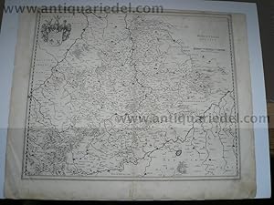
Wirtenberg Ducatus, anno 1640, Blaeu, Karte
Edité par Blaeu W.+J.,Atlases,Maps,Townboo
Vendeur : Hammelburger Antiquariat, Hammelburg, Allemagne
Evaluation du vendeur :
Hardcover. Etat : very good. Wirtenberg Ducatus, anno 1640, Blaeu, Karte Wirtenberg Ducatus. Blattmaß: 46x58 cm., Württemberg mit angrenzenden Gebieten zwischen Heidelberg, Schwäbisch Hall, Lauingen / Donau, Memmingen, Villingen / Schwarzwald, Freiburg und dem Rhein von Straßburg bis Mannheim, mit Stuttgart im Zentrum der Karte. Etwas fingerfleckig, kleinere Randläsuren, an den Rändern kleinere Reparaturen.
-
Stift Hirschfeld, anno 1650, Blaeu, altkoloriert, dt. Rückentext
Edité par Blaeu W.+J.,Atlases,Maps,Townboo
Vendeur : Hammelburger Antiquariat, Hammelburg, Allemagne
Evaluation du vendeur :
Hardcover. Etat : very good. Stift Hirschfeld, anno 1650, Blaeu, altkoloriert, franz. Rückentext Kupferkarte, verlegt bei Blaeu, Amsterdam, anno 1650, Blattmaß: 49x60 cm., Mittelfalz etwas geknittert; ansonsten guter Erhaltungszustand, breitrandig.
-
Anjou, anno 1640, Blaeu map
Edité par Blaeu W.+J.,Atlases,Maps,Townboo
Vendeur : Hammelburger Antiquariat, Hammelburg, Allemagne
Evaluation du vendeur :
Hardcover. Etat : very good. Anjou, anno 1640, Blaeu map Coppermap, edited by the Blaeu family, anno 1640, german text on verso, little waterstained, size of the leaf: 46x54 cm.
-
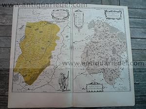
Vermandois/Capelle, 2 maps, Blaeu anno 1640
Edité par Blaeu W.+J.,Atlases,Maps,Townboo
Vendeur : Hammelburger Antiquariat, Hammelburg, Allemagne
Evaluation du vendeur :
Hardcover. Etat : very good. Vermandois/Capelle, 2 maps, Blaeu anno 1640 Title: Descriptio Veromanduorum . . . Gallice Vermandois [and] Gouvernement de la Cappelle . . . Map Maker: Willem Janszoon Blaeu Place / Date: Amsterdam / 1640 A nice pair of decorative regional maps on a single sheet. The Vermandois map is centered on the Oyse and Somme Rivers, and shows Chatelet, Beaurevoir, S. Quintin , Preone, Lafere, Channi and Noyon, amoung other larger towns in the region. The Cappelle map is centered on the Oyse and includes Vervins, La Cappelle, Aubanton and Marle, amoung others. Both with title carouches and additional embellishments. German lanquage on verso, size of the leaf: 46x54 cm., little waterstained, no cracs.
-
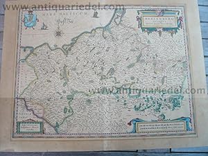
Meklenburg, anno 1650, G Blaeu, map
Edité par Blaeu W.+J.,Atlases,Maps,Townboo
Vendeur : Hammelburger Antiquariat, Hammelburg, Allemagne
Evaluation du vendeur :
Hardcover. Etat : very good. Please read german textKupferkarte, verlegt bei G. Blaeu, anno 1650, dt. Rückentext: "Das Hertzogthumb Meckelnburg" , alt koloriert, etwas gebräunt, untere Mittelfalz alt hinterlegt, min. Randläsuren. Blattmaß: 46x56 cm.
-
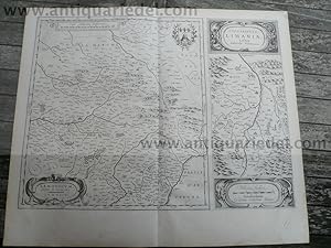
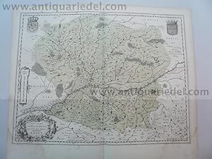
Lemovicum-Limosin, Limaniae, anno 1650, Blaeu
Edité par Blaeu W.+J.,Atlases,Maps,Townboo
Vendeur : Hammelburger Antiquariat, Hammelburg, Allemagne
Evaluation du vendeur :
Hardcover. Etat : very good. Lemovicum-Limosin, Limaniae, anno 1650, Blaeu Willem Janszoon Blaeu: Lemovicum - Lymosin (and) Topographia Limaniae Acutore Gabriele Simeoneo. Size of the leaf: 46x54 cm., german text on verso, good print, no cracs. Decorative map of the Limosin and Limoge region, with decorative cartouches. Large inset of the Elaver River region.
-
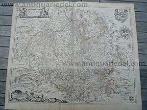
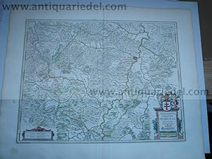
Bavaria Ducatus, anno 1665, Blaeu J., Atlas Major, altkoloriert,
Edité par Blaeu W.+J.,Atlases,Maps,Townboo
Vendeur : Hammelburger Antiquariat, Hammelburg, Allemagne
Evaluation du vendeur :
Hardcover. Etat : very good. Bavaria Ducatus, anno 1665, Blaeu J., Atlas Major, altkoloriert, span. Rückentext, Blattmaß: 64x52 cm. Das Blatt ist stark wasser-und sporenfleckig. Die detaillreiche Karte zeigt das Herzogtum Bayern, das Gebiet zwischen den Flüssen Lech, Donau, Inn-Salzach und Traun mit den Alpen im Süden. Die Karte wird begrenzt durch die Ortschaften Füssen , Landsberg und Augsburg im Westen, Donauwörth, Regensburg und Passau im Norden, Wels und Salzburg im Osten sowie Zell am See und Innsbruck im Süden. Rechts unten große, dekorative Titelkartusche "Bavaria Ducatus / Per Ger. Mercatorem" , auf der Kartusche sitzende weibliche Figur mit bayrischem Wappen. Darunter Meilenanzeiger (Milliaria Bavarica). Links daneben Verlegerhinweis "Apud Guiljelmum Blaeu.".
-
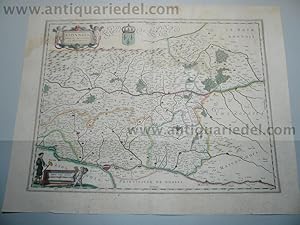
Lionnois,map,Blaeu,anno 1650, old coloured
Edité par Blaeu W.+J.,Atlases,Maps,Townboo
Vendeur : Hammelburger Antiquariat, Hammelburg, Allemagne
Evaluation du vendeur :
Hardcover. Etat : very good. Lionnois,map,Blaeu,anno 1650, old coloured Coppermap, edited by the Blaeu family, anno 1650: "LIONNOIS, FOREST, BEAUIOLOIS ET MASCONNOIS", Original coloured in outline. Oriented to the west on the top, wide margins, upper margin little waterstained, german text on verso, with the rivers Loire and Rhone. Size of the leaf: 45 x 54 cm., of the map: 38 x 50 cm.
-

Beauvais, map, Blaeu, anno 1650, german edition
Edité par Blaeu W.+J.,Atlases,Maps,Townboo
Vendeur : Hammelburger Antiquariat, Hammelburg, Allemagne
Evaluation du vendeur :
Hardcover. Etat : very good. Beauvais, map, Blaeu, anno 1650, german edition Coppermap, edited by the Blaeu family, approx. anno 1650, german text on verso, Beauvais in the centre of the map, little waterstained on margins, printed on thick paper. Size of the leaf: 46 x 54 cm.
-
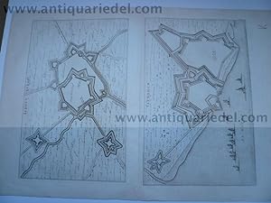
Duisburg-Ruhrort (ROEROORDT), anno 1700, Blaeu, Grundriss
Edité par Blaeu W.+J.,Atlases,Maps,Townboo
Vendeur : Hammelburger Antiquariat, Hammelburg, Allemagne
Evaluation du vendeur :
Hardcover. Etat : very good. Duisburg-Ruhrort (ROEROORDT), anno 1700, Blaeu, Grundriss. Planmaß: 37x49 cm. Referenz: Fauser, Nr. 3318. Wir haben auch einen unkolorierten Plan im Angebot. Bei Interesse bitten wir um Nachfrage.
-

Xaintonge-Isles Re & Oleron, map, Blaeu, anno 1650
Edité par Blaeu W.+J.,Atlases,Maps,Townboo
Vendeur : Hammelburger Antiquariat, Hammelburg, Allemagne
Evaluation du vendeur :
Hardcover. Etat : very good. Xaintonge-Isles Re & Oleron, map, Blaeu, anno 1650 Xaintonge-Isles Re & Oleron, map, Blaeu, anno 1650, from an german edition of Atlas Novus, below little waterstained. size of the leaf: 46x54 cm.
-

[Map] LUSATIA SUPERIOR (Upper Lusatia, Saxony, Prussia, Poland, Silesia)
Edité par W. Blaeu, Amsterdam, 1645
Map. Etat : Very Good. W. Blaeu (illustrateur). Elephant Folio - over 15 - 23" tall. (1645) Third state. A Very Good copy. Copper engraved map. Image dimensions: 20.75" x 16.5". Uncolored. Text relating to map on the reverse, in Dutch. Very faint foxing. Original fold visible. A few small creases in the margin. Unusual to find in its uncolored, original state. A Very Good copy. *** It was first published in 'Novus Atlas' in 1635, (Koeman, Atlantes Neerlandici I, p. 91, (142)). The third state of the Novus Atlas, was published in 1645. *** Published by Willem J. Blaeu, in 1645, at the height of the Dutch map-making era. An excellent example of the high quality, and accuracy of this leading Dutch map publisher.
-
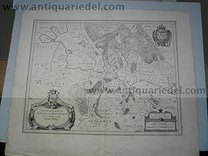
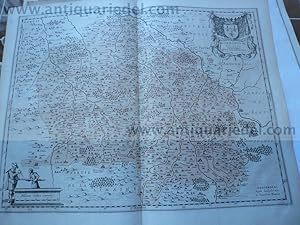
Sedan,Raucourt, map anno 1640, Blaeu J.
Edité par Blaeu W.+J.,Atlases,Maps,Townboo
Vendeur : Hammelburger Antiquariat, Hammelburg, Allemagne
Evaluation du vendeur :
Hardcover. Etat : very good. Sedan,Raucourt, map anno 1640, Blaeu J. Raucourt , Sedan - Lothringen, Champagne-Ardenne / Frankreich , Lorraine , Champagne-Ardenne / France Les Souverainetez de Sedan et de Ravcourt et la Prevoste de Doncheri Kupferstich, Blatt: ca 59 x 49,5 cm Gut erhalten, leicht gebräunt und fleckig, kleine Risse im Rand, Falte leicht knittrig. copper engraving , paper:ca 59 x 49,5 cm Good condition, light browning and staining, small tears in margins, soft folds in the middle.
-

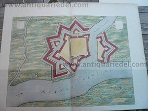
Steenwijk, Blaeu J., anno 1649, dutch edition
Edité par Blaeu W.+J.,Atlases,Maps,Townboo
Vendeur : Hammelburger Antiquariat, Hammelburg, Allemagne
Evaluation du vendeur :
Hardcover. Etat : very good. Copperengraving, "Stenovicum Obsessa", dutch text on verso, edited anno 1649 in Tooneel der Steden van de Vereenighde Niederlanden, size of the leaf: 46x66 cm., some small cracs on margins.
-
Borbonium ducatus. J.Blaeu, anno 1645, dt. Ausgabe
Edité par Blaeu W.+J.,Atlases,Maps,Townboo
Vendeur : Hammelburger Antiquariat, Hammelburg, Allemagne
Evaluation du vendeur :
Hardcover. Etat : very good. Borbonium ducatus. J.Blaeu, anno 1645, dt. Ausgabe, Blatt: 47x54 cm., dt. Rückentext, gering fleckig.
-

Wirtenberg Ducatus, anno 1662, Blaeu-Atlas Major
Edité par Blaeu W.+J.,Atlases,Maps,Townboo
Vendeur : Hammelburger Antiquariat, Hammelburg, Allemagne
Evaluation du vendeur :
Hardcover. Etat : very good. Wirtenberg Ducatus, anno 1662, Blaeu-Atlas Major, span. Rückentext. Wirtenberg Ducatus. Altkolorierte Karte, Blattmaß: 52x64 cm., Württemberg mit angrenzenden Gebieten zwischen Heidelberg, Schwäbisch Hall, Lauingen / Donau, Memmingen, Villingen / Schwarzwald, Freiburg und dem Rhein von Straßburg bis Mannheim, mit Stuttgart im Zentrum der Karte. Dekoratives Blatt, oben und unten jeweils großer Wasserfleck, geringfügig in die Karte reichend.
-

The Blaeu Atlas of Scotland - Scotland from Theatrum orbis terrarum, sive Atlas novus pars quinta, published by Joan Blaeu, Amsterdam, 1654
Edité par Birlinn Limited in association with National Library of Scotland, Edinburgh, 2006
ISBN 10 : 1841585858ISBN 13 : 9781841585857
Livre Edition originale
Hardcover. Etat : Very Good. First Edition Thus. 2006. 240pp. N0. 528 of 600 copies. "The Atlas contains 49 maps, many of them based on the original survey of Timothy Pont who toured the realm in the 1590s, during the reign of James VI, to produce maps of much of Scotland. In addition to the Pont Maps other material - both maps and chorographical - was collected over the next half century and sent to publisher Joan Blaeu in Amsterdam. This new edition of the "Blaeu Atlas of Scotland" includes all the original maps and text and, for the first time ever, contains a complete text in English, translated from the original Latin by I. C. Cunningham, a classics scholar and, formerly Keeper of Manuscripts, Maps and Music at the National Library of Scotland. This 21st-century edition of "Blaeu's Atlas of Scotland" will also contain an introduction by Professor Charles Withers, Professor of Historical Geography at the University of Edinburgh, and a translator's note from Ian C. Cunningham. This exclusive, numbered edition, is produced as close as possible to the format and size of the original and will contain images, courtesy of the National Library of Scotland taken directly from their original Blaeu Atlas of Scotland, first edition of 1654. This important publication is rare in that it not only provides a view and a record of Scotland 350 years ago but it is also of immense historical and geographical significance. This new edition will become a collector's piece for all those, worldwide, who are interested in maps and in Scotland's history." Casebound in quarter green cloth over illustrated paper covered boards within a protective slip case. Damage to the top right of the upper board (7mmx4mm loss) and a 4cmx3cm (barely perceptible) mark just below this. The book is otherwise in excellent condition with no inscriptions. The slipcase is in very good condition with a few bumps and scrapes. PLEASE NOTE: Very heavy book so extra will be needed for shipping to non-UK customers.
-
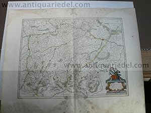
Anhalt-Principatus Anhaltinus, Blaeu, anno 1662
Edité par Blaeu W.+J.,Atlases,Maps,Townboo
Vendeur : Hammelburger Antiquariat, Hammelburg, Allemagne
Evaluation du vendeur :
Hardcover. Etat : very good. Principatus anhaltinus, Blaeu map, anno 1662 Principatus Anhaltinus, Kupferkarte aus Blaeu J. Atlas Major, span. Ausgabe, Teil III, verlegt anno 1662. Kartenmaß: 38 x 52 cm., breitrandig, an den Blatträndern, besonders oben und unten sporenfleckig; die Karte ist wenig betroffen. Alt grenzkoloriert. Zeigt die Elbe von Wittenberg bis nach Magdeburg, im Süden Mansfeld.
-
Hessen-Hassia Landgraviatus, anno 1650, Karte Blaeu
Edité par Blaeu W.+J.,Atlases,Maps,Townboo, 1650
Vendeur : Hammelburger Antiquariat, Hammelburg, Allemagne
Evaluation du vendeur :
Kein Einband. Etat : Befriedigend. Kupferkarte, verlegt von J. Blaeu, anno 1650, lat. Rückentext, Blatt: 50x60 cm., grenzkoloriert. Am unteren Rand kleiner restaurierter Einriss, ca. 15 cm.
-
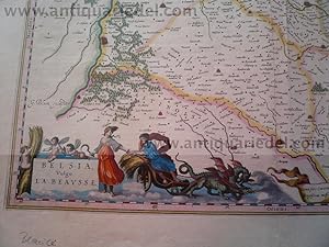
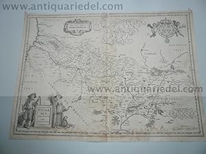
Belsia, vulgo la Beausse, map, anno 1650, Blaeu G.
Edité par Blaeu W.+J.,Atlases,Maps,Townboo
Vendeur : Hammelburger Antiquariat, Hammelburg, Allemagne
Evaluation du vendeur :
Hardcover. Etat : very good. Belsia, vulgo la Beausse, map, anno 1650, Blaeu Coppermap, edited by the Blaeu Family, approx. anno 1650, french text on verso, size of the leaf: 50x58 cm. some small cracs on margins, small restorations on upper and below centerfold (outside of the map).