
Montant total (1 article articles) :
Destination de la commande :

BOWEN, EMAN UEL (3 résultats)
Passer aux résultats principaux de la recherche
Type d'article
- Tous les types d'articles
- Livres (2)
- Magazines & Périodiques
- Bandes dessinées
- Partitions de musique
- Art, Affiches et Gravures
- Photographies
- Cartes (1)
-
Manuscrits &
Papiers anciens
Etat
- Tous
- Neuf
- Ancien ou d'occasion
Reliure
- Toutes
- Couverture rigide
- Couverture souple (1)
Particularités
- Edition originale
- Signé
- Jaquette
- Avec images (2)
- Sans impression ŕ la demande
Pays
Evaluation du vendeur
-

MINORCA / taken from an / Original Drawing / of an Actual / Survey / of the Island: / with some Improve- / ments by Eman:Bowen / Geogr. to his Majesty
Edité par LONDON: Printed for W.Owen, at Homer's Head Temple Bar. 1756., 1756
Vendeur : Paul Orssich HISPANIC STUDIES, LONDON, Royaume-Uni
Evaluation du vendeur :

17.5 x 22.5 cms. Color de época.Bello mapa de Menorca coloreado de época, en pas-partout. Muy buen ejemplar Recuadros: The Harbour of / PORT MAHON + The Streights of Gibraltar / with the Coast of Spain from / Cadiz to Malaga. Publicado en: The General Magazine of Arts and Sciences by Benjamin Martin. The insets note the distances from Mahón to Toulon (197 miles) and Gibraltar (540 miles).Jolly: Maps in British Periodicals. Vol.II. GENMAS 72. Martorell 93 (illustrated).
-
Rare Map of South Wales. A New and Accurate Map of South Wales. Containing the Counties of Pembroke, Glamorgan, Carmarthen, Brecknock, Cardigan and Radnor.
Edité par London; Printed for Carinton Bowles and Robt Sayer, [1760]., 1760
Vendeur : Keel Row Bookshop Ltd - ABA, ILAB & PBFA, Whitley Bay, Royaume-Uni
Membre d'association : ABA ILAB PBFA
Evaluation du vendeur :

Second Edition, n.d. but circa 1760. Map approx 158 cm x 113 cm, dissected into 32 parts and mounted onto linen. Uncoloured. Large title cartouche to upper left corner with allegorical figures and putti, and second large cartouche for dedication to the Prince of Wales to lower left corner with figures and armorial crest. Five large engraved views of Carmarthen, Brecknock (Brecon), Haverfordwest, Swansey (Swansea) and Tenby each approx 21 cm x 10. Distance tables at foot for principal journeys and Explanation key together with Scale in border at lower right corner (scale 3 inches to 5 miles). Linen to rear lightly surface soiled and foxed; some wear at folds including single 8 cm length with very minor loss and associated fraying. Small corner crease; 3 very minor holes to Haverfordwest engraving. Map itself partially faintly toned with some creasing at section edges; overall a clean and well preserved map. Large scale map of six counties by the noted engraver Emanuel Bowen (c.1694-1767). Cartographer to both George II of Great Britain and Louis XV of France Bowen's early work Britannia Depicta showed the English and Welsh counties, and he was commissioned in the mid eighteenth century to produce the Large English Atlas of county maps, a long-term and ambitious project. Bowen is also known for his small traveller's road strip maps for specific routes, often compared with the Sat-nav system used today. This map was printed in 6 sheets and shows towns, villages, churches, chapels and "Gentlemen's Seats" as well as rivers, roads, forests and other landscape features. The original 1729 first edition and this later undated edition are both rare. The dedication to George Prince of Wales determines that it was printed in or before 1760 as he acceded to the throne as George III during that year. Rare.
-
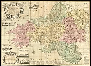
A new and accurate map of South Wales containing the counties of Pembroke, Glamorgan, Carnarthen, Brecknock, Cardigan, Radnor, wherein are exactly laid down and delineated from an actual survey and admeasurement: all the towns, villages, churches, chapels, gentlemen's seats together with the rivers, roads, divisions, mountains, forests, mines, bridges, lakes, fens &c. In their true position, situation and dystances. By Eman Bowen.
Edité par Printed for Carington Bowles, in St. Paul's Church Yard, and Robert Sayer No. 53 Fleet Street, [c1766]., London,, 1766
Vendeur : Daniel Crouch Rare Books Ltd, London, Royaume-Uni
Membre d'association : ABA ILAB PBFA
Evaluation du vendeur :

Carte
Bowen's large-scale map of South Wales Engraved map on six sheets, original hand colour in full-wash, dissected and backed on linen, folded and contained with marbled paper slipcase. This is the most detailed map of the South Welsh counties available in the eighteenth century, and even into the nineteenth, it was one of the main sources of information for Welsh travellers, land-owners and administrators alike. Although large-scale maps were being made for almost every English county, the Welsh counties generally received less attention individually, and are instead grouped together or depicted on smaller-scale representations. In 1720, Bowen had published an illustrated road atlas, his 'Britannia Depicta', in which he compiled, added to and commented on the British maps of previous cartographers. This atlas included each of the Welsh counties, equipping Bowen with a detailed familiarity of the region. This is evident from his later map of South Wales, which contains a wealth of information beyond routes and roads. Along with the "Table of Principal Road", it includes annotations about the geology of certain regions, labelled settlements, relief represented with illustrated hills, and an "Explanation" key which discusses the distances displayed in longitude and latitude. The map is as decorative as it is informative, with elaborate cartouches, five inset vignettes of important towns, and bold colours used to distinguish the counties. One impressive cartouche in the upper left corner contains the title, while in the lower corner a slightly smaller one presents the dedications, which runs as follows: "To his Royal Highness George Prince of Wales Electoral Prince of Brunswick Lunenburgh Duke of Cornwall and Edenburgh and Knight of the most noble order of the garter. This map of that part of your Highness's Principality call'd South Wales is most humbly dedicated and presented by, may it please your Royal Highness, your highness's most obedient & most humble servt. Eman Bowen". Such an extensive dedication demonstrates the importance of the patronage system to cartographers of the eighteenth century. Bowen was a prolific map engraver and publisher, and was appointed to the service of George II of England and Louis XV of France. He worked with his son to produce several county atlases, but ended his days in rather less grand fashion, dying in a workhouse in Clerkenwell. Roger lists only five institutional examples, and we are able to trace another example appearing at auction in the last 40 years. Bowen, 'Britannia Depicta', (1720); Morley, 'Genealogy of the Morleys in South Wales: Glamorgan and the Vale of Neath from 1700 to 1800', (Annals of Genealogical Research, 2012); Kentish, 'A Catalogue of Large-Scale County Maps of England and Wales published between 1705 and 1832', (Parchment Press, Oxford, 1997); Roger, 'The large scale county maps of the British Isles, 1596-1850: a union list', (Bodleian Library, 1972).

