Montant total (1 article articles) :
Destination de la commande :

CAPT HOWARD STANSBURY (4 résultats)
Passer aux résultats principaux de la recherche
Type d'article
- Tous les types d'articles
- Livres (1)
- Magazines & Périodiques
- Bandes dessinées
- Partitions de musique
- Art, Affiches et Gravures
- Photographies
- Cartes (3)
-
Manuscrits &
Papiers anciens
Etat
- Tous
- Neuf
- Ancien ou d'occasion
Reliure
- Toutes
- Couverture rigide (2)
- Couverture souple
Particularités
- Edition originale (2)
- Signé
- Jaquette
- Avec images (3)
- Sans impression ŕ la demande
Pays
Evaluation du vendeur
-
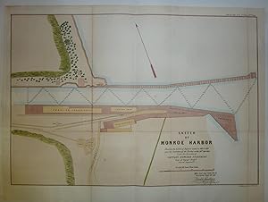
Sketch Of Monroe Harbor, Showing the Extent of Repairs Made in 1853 & 1854 and the Condition of the Harbor
Edité par GPO, Washington, 1854
Vendeur : Peninsula Books, Traverse City, MI, Etats-Unis
Evaluation du vendeur :

Carte
Map. Etat : Very Good. This early 1854 Monroe, Michigan map is hand-colored and shows Monroe Harbor with docks, railroad buildings, a plank road, Southern Michigan & Northern Indiana RR railroad line, etc. Senate Ex. Doc. #1, 2nd session, 33rd. Congress, vol. 1, part 3. single sheet. Old fold lines, as issued (with a little minor, unobjectionable browning). A rather large map that is suitable for framing. Ref: Karpinski 799a; Hand-colored Map; 22.25"x15.25".
-
Hardcover. Etat : Good. Lt. Gunnison and Charles Preuss (illustrateur). 1st Edition. Good. Contemporary cloth binding. Provenance - from Glasgow University Library, with the stamp sized coat of arms pasted beside the title of each map, as pictured. The map is paper and has a few splits to creases and the occasional hole to corners where creases intersect, all as pictured. In 1852, Stansbury was ordered to travel from Fort Leavenworth, Kansas, to survey the Great Salt Lake in Utah, evaluate emigration trails, especially in Oregon and Mormon trails, and to scout for possible locations for a transcontinental railroad. The expedition consisted of 18 men including his second in command Lieutenant John Williams Gunnison. Over the few years to follow the expedition covered the Great Salt Lake, Utah Lake and Cache Valley of northern Utah all the way to Fort Hall in Southern Idaho. Stansbury?s seminal 1852 map of the Great Salt lake region in Utah is considered to be the first accurate survey of the Great Basin as well as a cornerstone achievement in the mapping of the American West. Measurements: Map of the Great Salt Lake and Adjacent Country in the Territory of Utah: 44" x 32? Map of Reconnaissance between Fort Leavenworth on Missouri River, and the Great Salt Lake in the Territory of Utah: 30? x 69?.
-

Survey of the Harbor of Cleveland Ohio
Edité par Ackerman, New York, USA, 1855
Vendeur : Alexandre Antique Prints, Maps & Books, Toronto, ON, Canada
Membre d'association : ABAC ILAB
Evaluation du vendeur :

Carte
Etat : Very Good; Size : 415x504 (mm), 16.34x19.84 (Inches), Hand Colored.
-
EXPLORATION AND SURVEY OF THE VALLEY OF THE GREAT SALT LAKE OF UTAH, INCLUDING A RECONNAISSANCE OF A NEW ROUTE THROUGH THE ROCKY MOUNTAINS
Edité par Robert Armstrong Public Printer, 1853., Washington, 1853
Vendeur : BUCKINGHAM BOOKS, ABAA, ILAB, IOBA, GREENCASTLE, PA, Etats-Unis
Membre d'association : ABAA ILAB IOBA RMABA
Evaluation du vendeur :
Edition originale
First edition. Senate edition, Executive Document No. 3, Special Session, March, 1851. 2 volumes. Cloth, 495 pp. + 2 large folding maps in separate portfolio volume. 58 plates, including folding panoramic views. Many appendices, charts, tables, index. This is the first extensive survey of the Great Basin, and a major landmark in the cartography of the American West. "Captain Stansbury, commanded the detachment of the Army's topographical engineers which was directed in 1849 to explore and report on the Great Salt Lake Basin. Of particular interest were the newly established Mormon settlements, and the routes and passes through the Rockies for emigrants and possibly a railroad."---Wagner-Camp 219:1. In Mapping The Transmississippi West, Vol.3, pp.117-127, Carl Wheat describes the explorations of Stansbury and Lt. John Gunnison, and the important maps issued with this work as created by Stansbury; Gunnison; famous cartographer, Charles Preuss; and Albert Carrington. Both of the large maps are housed in a matching slipcase. Both maps are in very good condition. According to Wheat: "A good many details were added for the country lying between the established Oregon-California trail and Fremont's return from California in 1844, and these, together with the new cartography of the Great Salt Lake region, make the Stansbury expedition map one of the most important of its decade." Original cloth with gilt stamped back strip. Gentle wear to hinges otherwise very good copies. Complete with all 58 plates and the two large folding maps.