Montant total (1 article articles) :
Destination de la commande :

CONDER, T (17 résultats)
Passer aux résultats principaux de la recherche
Type d'article
- Tous les types d'articles
- Livres (13)
- Magazines & Périodiques
- Bandes dessinées
- Partitions de musique
- Art, Affiches et Gravures
- Photographies
- Cartes (4)
-
Manuscrits &
Papiers anciens
Etat
- Tous
- Neuf
- Ancien ou d'occasion
Reliure
- Toutes
- Couverture rigide (3)
- Couverture souple
Particularités
- Edition originale (2)
- Signé (2)
- Jaquette
- Avec images (9)
- Sans impression ŕ la demande
Livraison gratuite
Pays
Evaluation du vendeur
-
Bywyd Iesu Grist. Arweinydd i Astudiaeth. Amseryddiaeth, Cysondeb, ac Amcan yr Efengylau.
Edité par Cymdeithas y Traethodau Crefyddo
Vendeur : Goldstone Rare Books, Llandybie, CARMS, Royaume-Uni
Evaluation du vendeur :

Hardcover. Etat : Acceptable. Text in Welsh throughout. Cracked hinge. Some foxing and tanning to page edges and endpapers. Inscriptions on front endpaper and flyleaf. Bleaching and wear to bowed boards. Photograph available on request.
-
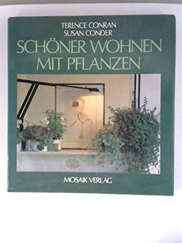
Schoener Wohnen mit Pflanzen.
Edité par Mosaik, Muenchen, 1998
ISBN 10 : 3570080978ISBN 13 : 9783570080979
Vendeur : Buchhandlung-Antiquariat Sawhney, Bonn, NRW, Allemagne
Evaluation du vendeur :

Livre
Gebunden mit Schutzumschlag. Abb., Botanik, 143 S.
-

A Map of the Land of Canaan According to Sacred History
Edité par Hogg, London, 1781
Vendeur : Clayton Fine Books, Shepherdstown, WV, Etats-Unis
Evaluation du vendeur :

Livre Edition originale
Unbound. Etat : Fine. First Edition. Copper engraving measuring aproximately 7.5" x 12". Mounted on a plain white handmade paper backing. The engraving was originally published in Wright's Complete British Family Bible. Near fine with foxing.
-
ORIGINAL ENGRAVED ANTIQUE MAP OF CAMBRIDGESHIRE. ?A New Map of Cambridgeshire, Drawn from the Latest Authorities.?
Edité par London, T. Conder Sculpt., Kings Arms, 16. Paternoster Row, ca1700, 1700
Vendeur : PROCTOR / THE ANTIQUE MAP & BOOKSHOP, DORCHESTER, Royaume-Uni
Membre d'association : PBFA
Evaluation du vendeur :
Original engraved map, Unframed. Engraved surface 19.5 x 16 cm (7.5 x 6 ins). Overall 22 x 17.5 cm (8.5 x 7 ins.) In very good condition. Some minor foxing spots around edges else a very good clean and bright example. The title of the county is contained in an ornamental cartouche, coloured green. With additional remarks, County Crest, and scale in miles.
-
Classical France - Antique Map, Contemporary Colouring 1798
Edité par R Wilkinson, London, 1796
Vendeur : K Books Ltd ABA ILAB, York, YORKS, Royaume-Uni
Membre d'association : ABA ILAB PBFA
Evaluation du vendeur :
Livre
No Binding. Etat : Very Good. T CONDER (illustrateur). A splendid original antique map of the France. Contemporary coloring and in excellent condition. Mounted and ready to frame. Extremely decorative and printed in 1796. Detailed and attractive map of France also showing Southern Britain.
-
Spain in Antiquity - Antique Map, Contemporary Colouring 1798
Edité par R Wilkinson, London, 1796
Vendeur : K Books Ltd ABA ILAB, York, YORKS, Royaume-Uni
Membre d'association : ABA ILAB PBFA
Evaluation du vendeur :
Livre
No Binding. Etat : Very Good. T CONDER (illustrateur). A splendid original antique map of Spain. Contemporary coloring and in excellent condition. Mounted and ready to frame. Extremely decorative and printed in 1796. Detailed and attractive map of Spain in antiquity.
-
ORIGINAL ENGRAVED ANTIQUE MAP OF CAMBRIDGESHIRE. ?A New Map of Cambridgeshire, Drawn from the Latest Authorities.?
Edité par London, T. Conder Sculpt., Kings Arms, 16. Paternoster Row, ca1700, 1700
Vendeur : PROCTOR / THE ANTIQUE MAP & BOOKSHOP, DORCHESTER, Royaume-Uni
Membre d'association : PBFA
Evaluation du vendeur :
Original engraved map, Unframed. Engraved surface 19.5 x 16 cm (7.5 x 6 ins). In very good condition. Some tanning top edge else a very good clean and bright example. The title of the county is contained in an ornamental cartouche, hand coloured. With additional remarks, County Crest, and scale in miles.
-
A New Map of Lincolnshire Drawn from the latest & best Authorities (1784)
Date d'édition : 1784
Vendeur : Waimakariri Books and Prints Limited, Oxford, Nouvelle-Zélande
Evaluation du vendeur :
Carte
No Binding. Etat : Very Good. A New Map of Lincolnshire Drawn from the latest & best Authorities. Engraved by T Conder 1784. Image size 15.5 x 18.5 cm approx. Very Good condition. Light use wear and age marks, good colouring, left hand margin has been strengthened to the verso. Price includes standard postage worldwide.
-
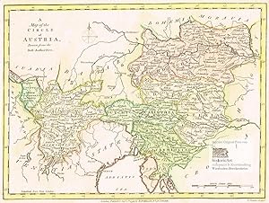
A Map of the Circle of Austria, Drawn from the Best Authorities. Die Österreichischen Erblande vor dem Ausbruch der französischen Revolutionskriege. Flächenkolorierte Original-Radierung von Condor bei Wilkinson 1794
Edité par London: Robert Wilkinson, 1794
Vendeur : historicArt Antiquariat & Kunsthandlung, Wiesbaden-Breckenheim, Allemagne
Evaluation du vendeur :
Carte Signé
1. altkolorierter Kupferstich von T. Conder (in der Platte signiert) auf rückseitig unbedrucktem Büttenkarton mit dekorativ abgesetztem Plattenrand, Plattengröße ca. 19,5 x 26 cm, (jeweils Höhe x Breite), sehr detaillierte und flächenkolorierte Landkarte, sehr gut erhalten 2100 gr.
-
![Image du vendeur pour Plan of the Town of Paramaribo. [Surinam] mis en vente par Librería Anticuaria Antonio Mateos](https://pictures.abebooks.com/inventory/md/md22675482031.jpg)
Plan of the Town of Paramaribo. [Surinam]
Vendeur : Librería Anticuaria Antonio Mateos, Malaga, Espagne
Membre d'association : AILA ILAB
Evaluation du vendeur :
London, J. Johnson, 1791, plano original grabado en cobre, con colores de época, 20 x 14 cm. SURINAM.
-
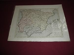
Hispania Antigua. Mapa coloreado
Edité par Jare, London, 1796
Vendeur : LIBRERIA ANTICUARIA EPOPEYA, Zaragoza, Espagne
Evaluation du vendeur :
buena conservación . .
-
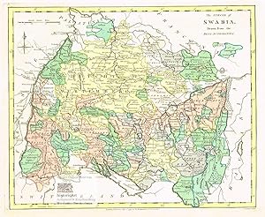
The Circle of Swabia. Drawn from the Best Authorities. Der Schwäbische Kreis zur Zeit der französischen Revolution. Herzogtum Württemberg von Heidelberg im Norden bis zum Bodensee im Süden. Seltene Landkarte vor den Napoleonischen Kriegen und der territorialen Neuordnung Europas im Wiener Kongress. Flächenkolorierter Original-Kupferstich von Conder bei Wilkinson 1794
Edité par London: Robert Wilkinson, 1794
Vendeur : historicArt Antiquariat & Kunsthandlung, Wiesbaden-Breckenheim, Allemagne
Evaluation du vendeur :
Carte Signé
1. altkolorierter Kupferstich von T. Conder (in der Platte signiert) auf rückseitig unbedrucktem schweren Büttenkarton mit dekorativ abgesetztem Plattenrand, Plattengröße ca. 23 x 28 cm, Kartongröße ca. 27 x 34 cm (jeweils Höhe x Breite), schön Fächenkoloratur, tadellos erhalten 2100 gr.
-
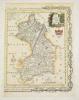
A NEW MAP OF YORKSHIRE DRAWN FROM THE LATEST & BEST AUTHORITIES, Hand-Coloured
Edité par A HOGG, 1784
Vendeur : K Books Ltd ABA ILAB, York, YORKS, Royaume-Uni
Membre d'association : ABA ILAB PBFA
Evaluation du vendeur :
Carte
No Binding. Etat : Very Good. T CONDER (illustrateur). Published by Alex'r Hogg, printed in the New British Traveller, with "Engraved for Walpole's New and Compelete British Traveller" above the top border. Elaborate border at either side. Shows borough and market towns, a few parks and villages, hills, rivers and roads. With the Arms of the city of York in the top right-hand corner with the title, with a circular compass indicator below. Colouring not contemporary, but delicately and expertly done. Mounted (matted) and ready to frame. Reference YAS255.
-
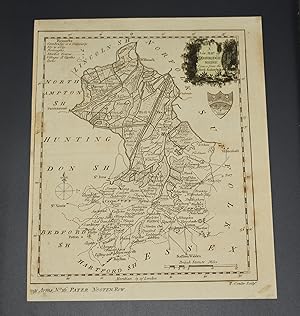
A NEW MAP OF YORKSHIRE, DRAWN FROM THE LATEST AND BEST AUTHORITIES - Coloured - 1786
Edité par Printed for Alexander Hogg, London, 1786
Vendeur : K Books Ltd ABA ILAB, York, YORKS, Royaume-Uni
Membre d'association : ABA ILAB PBFA
Evaluation du vendeur :
Livre
No Binding. Etat : Very Good. T CONDER (illustrateur). Shows borough and market towns, a few parks and villages, hills, rivers and roads. Top righ-hand corner are the Arms of the city of York, and the title with a circular compass indicator below. Bottom left are the remarks and the scale on the right. This is a reprint of the 1784 edition without the decorative border. The engraver's name is in the bottom right corner. YAS260. Mounted and framed in a Hogarth-style black and gold frame, size 17 x 12.5 inches. Sent framed only to the UK - otherwise sent matted and ready to frame.
-
Historical descriptions of new and elegant picturesque views of the antiquities of England and Wales:
Edité par Alex Hogg, London: King?s-Arms, No. 16, Paternoster-Row, 1786
Vendeur : Madoc Books (ABA-ILAB), Llandudno, CONWY, Royaume-Uni
Membre d'association : ABA ILAB IOBA PBFA
Evaluation du vendeur :
Livre Edition originale
Hardcover. Etat : Very Good. HAMILTON Robert. KITCHIN T. CONDER T. (illustrateur). 1st Edition. With 244 B&W images (maps, plans, coins, & topographical views) Tall Folio, first edition, contemporary full sheep, corners & edges worn. Spine, raised bands, gilt titles to red morocco label, edges worn along joints. Internally, frontis, [4], [1], 2-42 pp, (not paginated) + 127 leaves of text, 125 leaves of plates, made up of: 11 leaves single views, 6 leaves coins, 89 leaves each with 2 images, 1 leaf with 3 images, 4 leaves with 4 images, 1 leaf with 10 views, 1 with 6, 4 leaves with 9 plans, 9 leaves with 10 maps for total of 244 images. 2 text leaves & 1 plate leaf with paper repairs, title & frontis creased and split, without loss, paper repairs to 2 . (366*243mm). (ESTC T122443).
-
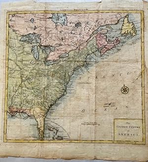
1788 The United States of America, T. Conder sculpt. London. Engraved for Dr. Gordon's History of the American War. Plate I.
Edité par T. Conder, London, 1788
Vendeur : Americana Books, ABAA, Stone Mt, GA, Etats-Unis
Membre d'association : ABAA ESA ILAB IOBA
Evaluation du vendeur :
Map. Etat : Very good. Map. Hand colored. Approx. 12" x 11". Plate I was engraved for Dr. Gordon's History of the American War published in 1788. A thin piece of tape at the far top edge with light edge wear around the thin slice of tape.
-
1788 The United States of America, T. Conder sculpt. London Engraved for Dr. Gordon's History of the American War. Plate I.
Edité par T. Conder, London, 1788
Vendeur : Americana Books, ABAA, Stone Mt, GA, Etats-Unis
Membre d'association : ABAA ESA ILAB IOBA
Evaluation du vendeur :
Map. Etat : Very good. Map. Hand colored. Approx. 12" x 11". Plate I was engraved for Dr. Gordon's History of the American War published in 1788. A thin piece of tape at the far top edge with light edge wear around the thin slice of tape.