
Montant total (1 article articles) :
Destination de la commande :

CORONELLI, VICENZO MARIA (44 résultats)
Passer aux résultats principaux de la recherche
Type d'article
- Tous les types d'articles
- Livres (38)
- Magazines & Périodiques
- Bandes dessinées
- Partitions de musique
- Art, Affiches et Gravures (1)
- Photographies
- Cartes (5)
-
Manuscrits &
Papiers anciens
Etat
- Tous
- Neuf
- Ancien ou d'occasion
Reliure
- Toutes
- Couverture rigide
- Couverture souple (2)
Particularités
- Edition originale (1)
- Signé
- Jaquette
- Avec images (40)
- Sans impression ŕ la demande
Pays
Evaluation du vendeur
-
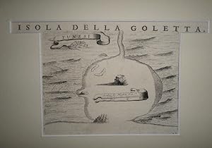
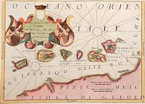
Isola della Goletta.
Vendeur : Librería Anticuaria Antonio Mateos, Malaga, Espagne
Membre d'association : AILA ILAB
Evaluation du vendeur :

(Venice, finales del Siglo XVII), mapa original grabado en madera de 14 x 17 cm. TUNEZ.
-
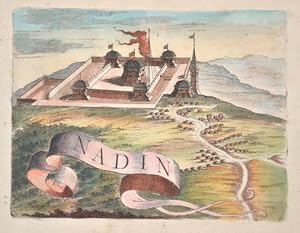
Nadin
Edité par Artist: Coronelli Vicenzo Maria ( - 1718 ) Venice; issued in: Venice; Coronelli Vicenzo Maria ( 1650 - 1718 ) Venice; Coronelli Vincenzo (1650 ? 1718) He was a cosmographer geographer biographer encyclopedist globe maker inventor and an expert of engeneering and hydraulics Extraordinarily versatile mind and an extremely tireless man he produced more than 140 pieces in different genres At the age of 15 he entered the Franciscan Order which he then guided as Gran Generale from 1699 He became famous as geographer and mathematician awakening the interest in these subjects in Italy at the end of the XVII century, 1650
Vendeur : Antique Sommer& Sapunaru KG, München, Allemagne
Membre d'association : ILAB VDA
Evaluation du vendeur :

Technic: Copper print; colorit: colored; condition: Perfect condition; size (in cm): 13 x 17,5 cm; Illustration of the Croatian village in the Zadar district. History: Following the decisive Ottoman victories, Croatia was split into civilian and military territories, with the partition formed in 1538. The military territories would become known as the Croatian Military Frontier and were under direct Imperial control. Ottoman advances in the Croatian territory continued until the 1593 Battle of Sisak, the first decisive Ottoman defeat, and stabilisation of borders. The Ottoman wars instigated great demographic changes. Croats migrated towards Austria and the present-day Burgenland Croats are direct descendants of these settlers. o replace the fleeing population, the Habsburgs encouraged the Christian populations of Bosnia and Serbia to provide military service in the Croatian Military Frontier. Serb migration into this region peaked during the Great Serb Migrations of 1690 and 1737?39. Between 1797 and 1809 the First French Empire gradually occupied the entire eastern Adriatic coastline and a substantial part of its hinterland, ending the Venetian and the Ragusan republics, establishing the Illyrian Provinces.
-
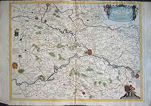
Alsacia Superiore e sue Dipendenze .
Edité par Venice, Venice, 1690
Vendeur : High Ridge Books, Inc. - ABAA, South Deerfield, MA, Etats-Unis
Membre d'association : ABAA ESA ILAB SNEAB
Evaluation du vendeur :
Modern outline color, very good condition. Decorative map of the Black Forest region of southern Germany.
-
Contado Di Namur.
Edité par Venice, c.1690. 460 x 610mm (18 x 24 inches)., 1690
Vendeur : Tooley, Adams & Co., Wallingford, OXON, Royaume-Uni
Evaluation du vendeur :
Uncoloured; light soiling, otherwise good. A map of the region of Belgium centred around Namur.
-
Contado di Namur
Edité par Venice, Venice, 1690
Vendeur : High Ridge Books, Inc. - ABAA, South Deerfield, MA, Etats-Unis
Membre d'association : ABAA ESA ILAB SNEAB
Evaluation du vendeur :
Map of central Belgium, centered on Namur and showing west to just past Charleroi. 20th century color, part-full, part-outline. North is oriented to the top right corner.
-
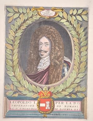
Leopoldo I per la D.G. Impertaore de Romani, re d Ungheria, di Boemia, ect.
Edité par Artist: Coronelli Vicenzo Maria ( - 1718 ) Venice; issued in: Venice; Coronelli Vicenzo Maria ( 1650 - 1718 ) Venice; Coronelli Vincenzo (1650 ? 1718) He was a cosmographer geographer biographer encyclopedist globe maker inventor and an expert of engeneering and hydraulics Extraordinarily versatile mind and an extremely tireless man he produced more than 140 pieces in different genres At the age of 15 he entered the Franciscan Order which he then guided as Gran Generale from 1699 He became famous as geographer and mathematician awakening the interest in these subjects in Italy at the end of the XVII century, 1650
Vendeur : Antique Sommer& Sapunaru KG, München, Allemagne
Membre d'association : ILAB VDA
Evaluation du vendeur :
Art / Affiche / Gravure
Technic: Copper print; colorit: colored; condition: Very good; size (in cm): 36 x 27; View of Leopold IHistory: The title page is one of the most important parts of the "front matter" or "preliminaries" of a book, as the data on it and its verso (together known as the "title leaf") are used to establish the "title proper and usually, though not necessarily, the statement of responsibility and the data relating to publication".This determines the way the book is cited in library catalogs and academic references. The title page often shows the title of the work, the person or body responsible for its intellectual content, and the imprint, which contains the name and address of the book's publisher and its date of publication. Particularly in paperback editions it may contain a shorter title than the cover or lack a descriptive subtitle. Further information about the publication of the book, including its copyright information, is frequently printed on the verso of the title page. The first printed books, or incunabula, did not have title pages: the text simply begins on the first page, and the book is often identified by the initial words?the incipit?of the text proper. Maps were usually published in atlases. And atlases were books with titles. And, again, titles were individual pieces of art. A publisher emphazised the importance of a book he published with a spectacular entrée. Usually the pictures of an atlas title page pertained in general to the subject matter: Measuring instruments, mythologigal, astronomical, religious, scientific, allegorical hints and facts were united in a composition which depicted the pride of progress in knowledge. An atlas title page often is just one superb artistic and jubilant cartouche.
-
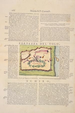
Fortezza del Volo. Il Forte Carababa
Edité par Artist: Coronelli Vicenzo Maria ( - 1718 ) Venice; issued in: Venice; Coronelli Vicenzo Maria ( 1650 - 1718 ) Venice; Coronelli Vincenzo (1650 ? 1718) He was a cosmographer geographer biographer encyclopedist globe maker inventor and an expert of engeneering and hydraulics Extraordinarily versatile mind and an extremely tireless man he produced more than 140 pieces in different genres At the age of 15 he entered the Franciscan Order which he then guided as Gran Generale from 1699 He became famous as geographer and mathematician awakening the interest in these subjects in Italy at the end of the XVII century, 1650
Vendeur : Antique Sommer& Sapunaru KG, München, Allemagne
Membre d'association : ILAB VDA
Evaluation du vendeur :
Technic: Copper print; colorit: colored; condition: Some folds; size (in cm): 37,5 x 27,5; Map depicts on the front and on reverse, Fort Carababa on the island Creta. History: The island of Creta is first described in texts from the Syrian city of Mari in the 18th century BC. BC called Kaptara, which are later repeated in Neoassyrian records and in the Bible (Caphtor). It was also known as Keftiu in ancient Egypt, strongly suggesting that a shape similar to both was the Minoan name for the island.
-
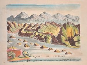
Capo Matapan
Edité par Artist: Coronelli Vicenzo Maria ( - 1718 ) Venice; issued in: Venice; Coronelli Vicenzo Maria ( 1650 - 1718 ) Venice; Coronelli Vincenzo (1650 ? 1718) He was a cosmographer geographer biographer encyclopedist globe maker inventor and an expert of engeneering and hydraulics Extraordinarily versatile mind and an extremely tireless man he produced more than 140 pieces in different genres At the age of 15 he entered the Franciscan Order which he then guided as Gran Generale from 1699 He became famous as geographer and mathematician awakening the interest in these subjects in Italy at the end of the XVII century, 1650
Vendeur : Antique Sommer& Sapunaru KG, München, Allemagne
Membre d'association : ILAB VDA
Evaluation du vendeur :
Technic: Copper print; colorit: original colored; condition: Perfect condition; size (in cm): 13 x 17 cm; Map shows Cape Tenaro or Cape Matapan, located at the southern tip of the Mani peninsula in the Peloponnese, Greece. History: Greece is considered the cradle of Western civilisation, being the birthplace of democracy, Western philosophy, Western literature, historiography, political science, major scientific and mathematical principles, Western drama and the Olympic Games. From the eighth century B.C., the Greeks were organised into various independent city-states, known as poleis (singular polis), which spanned the entire Mediterranean region and the Black Sea. Philip of Macedon united most of the Greek mainland in the fourth century BC, with his son Alexander the Great rapidly conquering much of the ancient world, from the eastern Mediterranean to India. Greece was annexed by Rome in the second century B.C., becoming an integral part of the Roman Empire and its successor, the Byzantine Empire, which adopted the Greek language and culture. The Greek Orthodox Church, which emerged in the first century A.D., helped shape modern Greek identity and transmitted Greek traditions to the wider Orthodox World. After falling under Ottoman dominion in the mid-15th century, Greece emerged as a modern nation state in 1830 following a war of independence.
-
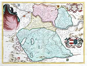
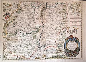
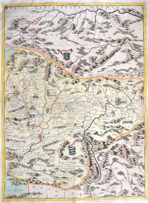
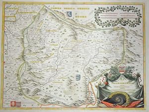
Austria Superiore
Edité par Coronelli, V. M., Venice, 1690
Vendeur : Antikvariat Krenek, Prag, Rébublique tchčque
Membre d'association : ILAB
Evaluation du vendeur :
Upper Austria. "Austria Superiore". Orig. copperplate engraving, V. M. Coroneli, Venice, 1690 after G. B. Spinelli map. Orig. old colouring. With decorative title cartouche, a cartouche with 2 coats of arms, another cartouche with the scale of map and 4 smaller regional coats of arms. 46:61 cm (18 1/4 x 24 inch.). Map of Upper Austria. - Vincenzo Maria Coronelli (1650-1718) was an Italian Franciscan friar, cosmographer, cartographer and publisher.
-
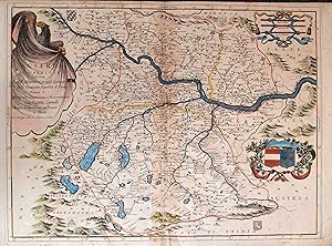
Austria Superiore
Edité par Venice, Venice, 1690
Vendeur : High Ridge Books, Inc. - ABAA, South Deerfield, MA, Etats-Unis
Membre d'association : ABAA ESA ILAB SNEAB
Evaluation du vendeur :
Modern outline color. Minor foxing, light discoloration near center fold. Depicts much of western Austria, generally centered on Linz.
-
Ducato di Luxembourgo
Edité par Venice, Venice, 1690
Vendeur : High Ridge Books, Inc. - ABAA, South Deerfield, MA, Etats-Unis
Membre d'association : ABAA ESA ILAB SNEAB
Evaluation du vendeur :
Uncolored map of Luxemburg. Generally good, but damaged along center fold with 4 very small holes. From Coronelli's Corso Geografico Universale. A strong impression.
-
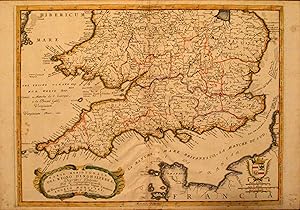
Parte Meridionale del Regno d'Inghilterra, Descritto e Dedicato .
Edité par Venice, Venice, 1691
Vendeur : High Ridge Books, Inc. - ABAA, South Deerfield, MA, Etats-Unis
Membre d'association : ABAA ESA ILAB SNEAB
Evaluation du vendeur :
Southern portion of Coronelli's two-map depiction of Great Britain which stand alone as a map of the English Channel. Later outline color by county. Light stains and soiling in margins, bumped at bottom near center.
-
Le Molucche , dedictae al molto reu pre majestro carlo Tosi, Min Con gia Provinceale
Edité par Artist: Coronelli Vicenzo Maria ( - 1718 ) Venice; issued in: Venice; Coronelli Vicenzo Maria ( 1650 - 1718 ) Venice; Coronelli Vincenzo (1650 ? 1718) He was a cosmographer geographer biographer encyclopedist globe maker inventor and an expert of engeneering and hydraulics Extraordinarily versatile mind and an extremely tireless man he produced more than 140 pieces in different genres At the age of 15 he entered the Franciscan Order which he then guided as Gran Generale from 1699 He became famous as geographer and mathematician awakening the interest in these subjects in Italy at the end of the XVII century, 1650
Vendeur : Antique Sommer& Sapunaru KG, München, Allemagne
Membre d'association : ILAB VDA
Evaluation du vendeur :
Technic: Copper print; colorit: original colored; condition: Margins cutted; size (in cm): 23 x 31; Map shows the islands of the Molucces, Ternale, Tidore, Timor, Machian, Bachian, the coast of Dschailolo and a beautiful cartush. History: The Maluku Islands are an archipelago within Banda Sea, Indonesia. Tectonically they are located on the Halmahera Plate within the Molucca Sea Collision Zone. Geographically they are located east of Sulawesi, west of New Guinea, and north and east of Timor. The islands were known as the Spice Islands due to the nutmeg, mace and cloves that were originally exclusively found there, the presence of which sparked colonial interest from Europe in the 16th century. The Maluku Islands formed a single province from Indonesian independence until 1999, when it was split into two provinces. A new province, North Maluku, incorporates the area between Morotai and Sula, with the arc of islands from Buru and Seram to Wetar remaining within the existing Maluku Province.
-
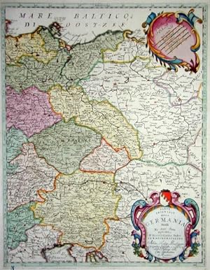
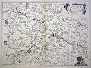
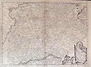
Parte orientale della Germania Divisa Ne Suoi Stati dedicata.
Edité par Artist: Coronelli Vicenzo Maria ( - 1718 ) Venice; issued in: Venice; Coronelli Vicenzo Maria ( 1650 - 1718 ) Venice; Coronelli Vincenzo (1650 ? 1718) He was a cosmographer geographer biographer encyclopedist globe maker inventor and an expert of engeneering and hydraulics Extraordinarily versatile mind and an extremely tireless man he produced more than 140 pieces in different genres At the age of 15 he entered the Franciscan Order which he then guided as Gran Generale from 1699 He became famous as geographer and mathematician awakening the interest in these subjects in Italy at the end of the XVII century, 1650
Vendeur : Antique Sommer& Sapunaru KG, München, Allemagne
Membre d'association : ILAB VDA
Evaluation du vendeur :
Technic: Copper print; colorit: colored; condition: Very good; size (in cm): 57 x 44; Map shows total Eastern Germany with Brandenbourg, Bohemia, Silesia and MoraviaHistory: The concept of Germany as a distinct region in central Europe can be traced to Roman commander Julius Caesar, who referred to the unconquered area east of the Rhine as Germania, thus distinguishing it from Gaul (France), which he had conquered. In the High Middle Ages, the regional dukes, princes and bishops gained power at the expense of the emperors. Martin Luther led the Protestant Reformationagainst the Catholic Church after 1517, as the northern states became Protestant, while the southern states remained Catholic. The two parts of the Holy Roman Empire clashed in the Thirty Years' War (1618?1648). 1648 marked the effective end of the Holy Roman Empire and the beginning of the modern nation-state system, with Germany divided into numerous independent states, such as Prussia, Bavaria and Saxony.
-
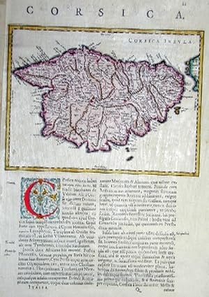
Corsica
Edité par Artist: Coronelli Vicenzo Maria ( - 1718 ) Venice; issued in: Venice; Coronelli Vicenzo Maria ( 1650 - 1718 ) Venice; Coronelli Vincenzo (1650 ? 1718) He was a cosmographer geographer biographer encyclopedist globe maker inventor and an expert of engeneering and hydraulics Extraordinarily versatile mind and an extremely tireless man he produced more than 140 pieces in different genres At the age of 15 he entered the Franciscan Order which he then guided as Gran Generale from 1699 He became famous as geographer and mathematician awakening the interest in these subjects in Italy at the end of the XVII century, 1650
Vendeur : Antique Sommer& Sapunaru KG, München, Allemagne
Membre d'association : ILAB VDA
Evaluation du vendeur :
Technic: Copper print; colorit: colored; condition: Very good; size (in cm): 36 x 24; Map shows the Island of CorsicaHistory: In 1729 the Corsican Revolution for independence from Genoa began, first led by Luiggi Giafferi and Giacinto Paoli, and later by Paoli's son, Pasquale Paoli. After 26 years of struggle against the Republic of Genoa, the independent Corsican Republic was proclaimed in 1755 under the leadership of Pasquale Paoli and remained sovereign until 1769, when the island was conquered by France. The first Corsican Constitution was written in Italian (the language of culture in Corsica until the middle of the 19th century) by Paoli.
-
Contado d'Hannonia c. Vescouato di Cambrai
Edité par Venice, Venice, 1690
Vendeur : High Ridge Books, Inc. - ABAA, South Deerfield, MA, Etats-Unis
Membre d'association : ABAA ESA ILAB SNEAB
Evaluation du vendeur :
Uncolored map of western Belgium and eastern France, from south of Brussels (not shown) to Cambrai, France, generally centered around the towns of Mons and Charleroi. Very good condition, light staining at top corners. Cartouche at top right, blank heraldic shield at left side.
-
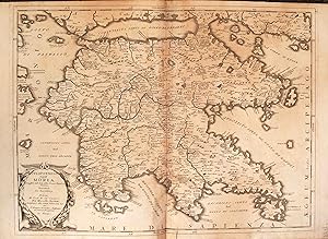
Peloponneso, Hoggidi Morea .
Edité par Venice, Venice, 1690
Vendeur : High Ridge Books, Inc. - ABAA, South Deerfield, MA, Etats-Unis
Membre d'association : ABAA ESA ILAB SNEAB
Evaluation du vendeur :
Uncolored map of the Peloponnesos. Good to very good condition with two short tear just into bottom border, very mild offsetting and soiling.
-
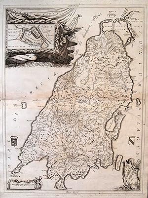
Transilvania Erdelyorssag
Edité par Artist: Coronelli Vicenzo Maria ( - 1718 ) Venice; issued in: Venice; Coronelli Vicenzo Maria ( 1650 - 1718 ) Venice; Coronelli Vincenzo (1650 ? 1718) He was a cosmographer geographer biographer encyclopedist globe maker inventor and an expert of engeneering and hydraulics Extraordinarily versatile mind and an extremely tireless man he produced more than 140 pieces in different genres At the age of 15 he entered the Franciscan Order which he then guided as Gran Generale from 1699 He became famous as geographer and mathematician awakening the interest in these subjects in Italy at the end of the XVII century, 1650
Vendeur : Antique Sommer& Sapunaru KG, München, Allemagne
Membre d'association : ILAB VDA
Evaluation du vendeur :
Technic: Copper print; colorit: colored; condition: Perfect condition; size (in cm): 61 x 44,5 cm; Map shows the east part of Transilvania in Romania with three coats of arms. History: Transilvania is a historical region located in what is today the central part of Romania. Bound on the east and south by its natural borders, the Carpathian mountain range, historical Transylvania extended westward to the Apuseni Mountains. The region of Transylvania is known for the scenic beauty of its Carpathian landscape and its rich history. It also contains major cities such as Cluj-Napoca, Bra_ov, Sibiu and Târgu Mure_. The Habsburgs acquired the territory shortly after the Battle of Vienna in 1683. In 1687, the rulers of Transylvania recognized the suzerainty of the Habsburg emperor Leopold I, and the region was officially attached to the Habsburg Empire.
-
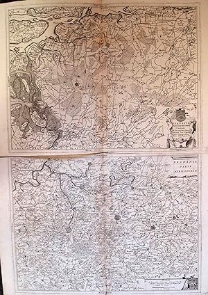
Brabante Parte Settentrionale/Brabante Parte Meridionale
Edité par Venice, Venice, 1690
Vendeur : High Ridge Books, Inc. - ABAA, South Deerfield, MA, Etats-Unis
Membre d'association : ABAA ESA ILAB SNEAB
Evaluation du vendeur :
2 uncolored maps of Belgium, with Brussels on the southern sheet, Antwerp and Breda, Netherlands on the northern. The southern sheet has a split along the bottom of the center fold, with no loss. Very detailed and decorative map from Coronelli?s Corso Geografico Universale. Coronelli is widely recognised as one of Italy's greatest cartographers. He received an ecclesiastical education at the convent of the Minor Conventuals and also studied theology in Rome. He made very famous globes (including an impressive very large-scale pair for Louis XIV) and some of the most interesting and decorative atlases of the 17th century like Atlante Veneto, Isolario, Corso Geografico Universale, Libro dei Globi. These important works are all finely engraved in his unique style. In 1680 Coronelli also founded the oldest surviving geographical society, The Argonauts Accademy.
-
Abissinia, doue sono le Fonti del Nilo.
Edité par Artist: Coronelli Vicenzo Maria ( - 1718 ) Venice; issued in: Venice; Coronelli Vicenzo Maria ( 1650 - 1718 ) Venice; Coronelli Vincenzo (1650 ? 1718) He was a cosmographer geographer biographer encyclopedist globe maker inventor and an expert of engeneering and hydraulics Extraordinarily versatile mind and an extremely tireless man he produced more than 140 pieces in different genres At the age of 15 he entered the Franciscan Order which he then guided as Gran Generale from 1699 He became famous as geographer and mathematician awakening the interest in these subjects in Italy at the end of the XVII century, 1650
Vendeur : Antique Sommer& Sapunaru KG, München, Allemagne
Membre d'association : ILAB VDA
Evaluation du vendeur :
Technic: Copper print; colorit: original colored; condition: Very good; size (in cm): 45 x 60; Map shows total Ethiopia ( Abissinia), on inset map the river Nil. History: According to the "Out-of-Africa theory", Africa is considered the "cradle of mankind", where homo development led to the development of the anatomically modern human Homo sapiens. One of the earliest advanced civilizations in mankind was formed in ancient Egypt. Over the millennia, various "great empires" such as the Empire of Abyssinia emerged on the continent. There were other kingdoms in West Africa, such as the Ashanti and Haussa, but they emerged much later. There were also some important cultures in East and South Africa, as in the area of today's Sudan, then called Nubia or Kush. Nubian pharaohs ruled all of Egypt for a dynasty. For example, the inhabitants of Greater Zimbabwe were important cultures in southern Africa. This stone castle was architecturally a masterpiece at that time and important for trade between the peoples of the south and east. The Swahili were known in East Africa. North Africa was connected to Europe and the Near East by the Mediterranean rather than separated. Carthage, a foundation of the Phoenicians in what is now Tunisia, was around the middle of the 1st millennium BC. The dominant power in the western Mediterranean until it was replaced by Rome in the Punic Wars. This prevailed from 30 BC. BC (conquest of Egypt) over all of North Africa. Even the ancient Egyptians (Queen Hatshepsut) made trips to Punt, probably in what is now Somalia. The kingdom of the Queen of Sheba, which probably had its center in southern Arabia, is said to have spanned parts of the Horn from Africa to the north of Ethiopia.
-
Isola di S. Maura
Edité par Venice, Venice, 1690
Vendeur : High Ridge Books, Inc. - ABAA, South Deerfield, MA, Etats-Unis
Membre d'association : ABAA ESA ILAB SNEAB
Evaluation du vendeur :
Uncolored map of the island of Saint Maura, now Lefkada, on the western coast of Greece. Excellent condition. Inset plan of the Castle Saint Maura at top left, incorporated into the cartouche at the top left which shows an owl and a gull.
-
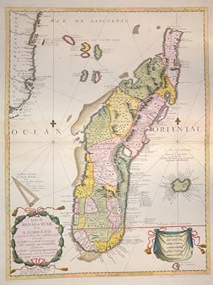
Isola di Magagascar o di S. Lorenzo
Edité par Artist: Coronelli Vicenzo Maria ( - 1718 ) Venice; issued in: Venice; Coronelli Vicenzo Maria ( 1650 - 1718 ) Venice; Coronelli Vincenzo (1650 ? 1718) He was a cosmographer geographer biographer encyclopedist globe maker inventor and an expert of engeneering and hydraulics Extraordinarily versatile mind and an extremely tireless man he produced more than 140 pieces in different genres At the age of 15 he entered the Franciscan Order which he then guided as Gran Generale from 1699 He became famous as geographer and mathematician awakening the interest in these subjects in Italy at the end of the XVII century, 1650
Vendeur : Antique Sommer& Sapunaru KG, München, Allemagne
Membre d'association : ILAB VDA
Evaluation du vendeur :
Technic: Copper print; colorit: original colored; condition: Perfect condition; size (in cm): 60 x 45 cm; Splendid map showing the island of Madagascar and the coast of Mozambique with a title cartouche and a curtain with mileage indicator. History: Madagascar- officially the Republic of Madagascar , and previously known as the Malagasy Republic, is an island country in the Indian Ocean, off the coast of East Africa. Madagascar was an important transoceanic trading hub connecting ports of the Indian Ocean in the early centuries following human settlement. The written history of Madagascar began with the Arabs, who established trading posts along the northwest coast by at least the 10th century. From about 1774 to 1824, Madagascar gained prominence among pirates and European traders, particularly those involved in the trans-Atlantic slave trade. Many European sailors were shipwrecked on the coasts of the island, among them Robert Drury, whose journal is one of the few written depictions of life in southern Madagascar during the 18th century. The wealth generated by maritime trade spurred the rise of organized kingdoms on the island, some of which had grown quite powerful by the 17th century. Among these were the Betsimisaraka alliance of the eastern coast and the Sakalava chiefdoms of Menabe and Boina on the west coast. The Kingdom of Imerina, located in the central highlands with its capital at the royal palace of Antananarivo, emerged at around the same time under the leadership of King Andriamanelo.
-
Isole Azzori, o Azzoridi dette alrimenti Acipitrum Fertiae, Flandrica, et Superiores.
Edité par Venice, 1690
Vendeur : Alexandre Antique Prints, Maps & Books, Toronto, ON, Canada
Membre d'association : ABAC ILAB
Evaluation du vendeur :

Carte
Size : 463x615 (mm), 18.25x24.25 (Inches), Black & White Very Good, upper margin has been extended.
-
La Transilvania
Edité par Artist: Coronelli Vicenzo Maria ( - 1718 ) Venice; issued in: Venice; Coronelli Vicenzo Maria ( 1650 - 1718 ) Venice; Coronelli Vincenzo (1650 ? 1718) He was a cosmographer geographer biographer encyclopedist globe maker inventor and an expert of engeneering and hydraulics Extraordinarily versatile mind and an extremely tireless man he produced more than 140 pieces in different genres At the age of 15 he entered the Franciscan Order which he then guided as Gran Generale from 1699 He became famous as geographer and mathematician awakening the interest in these subjects in Italy at the end of the XVII century, 1650
Vendeur : Antique Sommer& Sapunaru KG, München, Allemagne
Membre d'association : ILAB VDA
Evaluation du vendeur :
Technic: Copper print; colorit: colored; condition: Very good; size (in cm): 45 x 60; Map shows total Transilvania with several coat of arms ( such as Transilvania and other Rumanian privinces) and 2 decorative cartouches. History: Transilvania is a historical region located in what is today the central part of Romania. Bound on the east and south by its natural borders, the Carpathian mountain range, historical Transylvania extended westward to the Apuseni Mountains. The region of Transylvania is known for the scenic beauty of its Carpathian landscape and its rich history. It also contains major cities such as Cluj-Napoca, Bra_ov, Sibiu and Târgu Mure_. The Habsburgs acquired the territory shortly after the Battle of Vienna in 1683. In 1687, the rulers of Transylvania recognized the suzerainty of the Habsburg emperor Leopold I, and the region was officially attached to the Habsburg Empire.
-
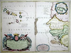
Bocche del Fiume Negro Isule di Capo Verde
Edité par Artist: Coronelli Vicenzo Maria ( - 1718 ) Venice; issued in: Venice; Coronelli Vicenzo Maria ( 1650 - 1718 ) Venice; Coronelli Vincenzo (1650 ? 1718) He was a cosmographer geographer biographer encyclopedist globe maker inventor and an expert of engeneering and hydraulics Extraordinarily versatile mind and an extremely tireless man he produced more than 140 pieces in different genres At the age of 15 he entered the Franciscan Order which he then guided as Gran Generale from 1699 He became famous as geographer and mathematician awakening the interest in these subjects in Italy at the end of the XVII century, 1650
Vendeur : Antique Sommer& Sapunaru KG, München, Allemagne
Membre d'association : ILAB VDA
Evaluation du vendeur :
Technic: Copper print; colorit: colored; condition: Very good; size (in cm): 46 x 60; Map shows the island of Capverden and the west coast of Africa. History: The uninhabited islands were circled by António Fernandes in 1445 and discovered and entered for the first time in 1456 by the Venetian Alvise Cadamosto, who was in Portuguese service (Boa Vista). Antonio da Noli, a Genoese captain who also sailed on behalf of the Portuguese Prince Henry the Navigator, continued to explore the islands from 1458 in collaboration with Diogo Gomes, discovered most of the rest of the eastern Cape Verde Islands and baptized the archipelago with the name Ilhas de Cabo Verde and began settling the islands as governor of the Portuguese crown from 1461. In fact, Diogo Gomes later claimed to be the first of the two to have seen the island of Santiago from afar and also to have been the first to set foot on it. Antonio da Noli, however, managed to return to Portugal earlier, and he was then understandably rewarded by Heinrich the Navigator with the encouragement of the discovery, which, in the words of Diogo Gomes, "I, Gomes, discovered". Because of the rivalry between the two, Diogo Gomes is considered to be the true discoverer of the main island of Santiago in Portuguese historiography. The islands were named by the Portuguese after Cabo Verde (Green Cape) on the west coast of Africa.
-
![Image du vendeur pour [Gore Map of India, Pakistan and Arabia] mis en vente par Alexandre Antique Prints, Maps & Books](https://pictures.abebooks.com/inventory/md/md1246590942.jpg)
[Gore Map of India, Pakistan and Arabia]
Edité par Venice, 1688
Vendeur : Alexandre Antique Prints, Maps & Books, Toronto, ON, Canada
Membre d'association : ABAC ILAB
Evaluation du vendeur :
Etat : Excellent. The width of the map listed (290mm - 11 3/8") is the width at which the width between the engraving marks is at a maximum. [The vertical engraving marks are curved as this is a gore map], Size : 495x290 (mm), 19.5x11.375 (Inches), Hand Colored in Outline.
-
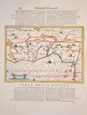
Isole della Guinea
Edité par Artist: Coronelli Vicenzo Maria ( - 1718 ) Venice; issued in: Venice; Coronelli Vicenzo Maria ( 1650 - 1718 ) Venice; Coronelli Vincenzo (1650 ? 1718) He was a cosmographer geographer biographer encyclopedist globe maker inventor and an expert of engeneering and hydraulics Extraordinarily versatile mind and an extremely tireless man he produced more than 140 pieces in different genres At the age of 15 he entered the Franciscan Order which he then guided as Gran Generale from 1699 He became famous as geographer and mathematician awakening the interest in these subjects in Italy at the end of the XVII century, 1650
Vendeur : Antique Sommer& Sapunaru KG, München, Allemagne
Membre d'association : ILAB VDA
Evaluation du vendeur :
Technic: Copper print; colorit: original colored; condition: Very good; size (in cm): 23,5 x 30 cm; Map shows the Gulf of Guinea with the countries Sierra Leone, Liberia, Ivory Coast, Ghana, Togo, Benin and Nigeria in Africa. History: The land that is now Guinea belonged to a series of African empires until France colonized it in the 1890s, and made it part of French West Africa. Guinea declared its independence from France on 2 October 1958. The country is named after the Guinea region. Guinea is a traditional name for the region of Africa that lies along the Gulf of Guinea. It stretches north through the forested tropical regions and ends at the Sahel. The English term Guinea comes directly from the Portuguese word Guiné, which emerged in the mid-15th century to refer to the lands inhabited by the Guineus, a generic term for the black African peoples south of the Senegal River, in contrast to the "tawny" Zenaga Berbers above it, whom they called Azenegues or Moors.
-
Corso del Reno, parte meridionale,Dedicato all Illustrissimo, et Eccellentissimo S.Girolamo Querini, Procuratore di S.Marco.
Edité par Artist: Coronelli Vicenzo Maria ( - 1718 ) Venice; issued in: Venice; Coronelli Vicenzo Maria ( 1650 - 1718 ) Venice; Coronelli Vincenzo (1650 ? 1718) He was a cosmographer geographer biographer encyclopedist globe maker inventor and an expert of engeneering and hydraulics Extraordinarily versatile mind and an extremely tireless man he produced more than 140 pieces in different genres At the age of 15 he entered the Franciscan Order which he then guided as Gran Generale from 1699 He became famous as geographer and mathematician awakening the interest in these subjects in Italy at the end of the XVII century, 1650
Vendeur : Antique Sommer& Sapunaru KG, München, Allemagne
Membre d'association : ILAB VDA
Evaluation du vendeur :
Technic: Copper print; colorit: original colored; condition: Very good; size (in cm): 87,5 x 60,5; Map shows the total River RheinHistory: The headwaters of the Rhine lie predominantly in the Swiss canton of Graubünden; its estuary arms reach the North Sea in the Netherlands, where it is the most water-rich tributary. The Rhine bears its name without distinguishing additions only from the confluence of the Vorderrhein and Hinterrhein at Tamins-Reichenau. Traditionally, Lake Toma near the Oberalp Pass near Sedrun in the Gotthard region is considered the source of the Vorderrhein and the Rhine as a whole. The Hinterrhein rises in the high valley Rheinwald below the Rheinwaldhorn. At Tamins-Reichenau the Vorderrhein and Hinterrhein join to form the Alpenrhein.Hochrhein: The Hochrhein begins at Stein am Rhein at the western end of the Untersee. In contrast to the Alpine Rhine and the Upper Rhine, it flows mainly to the west, dropping from 395 m to 252 m. The Rhine is the first major river in the world. In the center of Basel, the first large city on the course of the stream, lies the "Rhine bend"; here the High Rhine ends. Upper Rhine: At Mainz, the Rhine leaves the Upper Rhine Graben and flows through the Mainz Basin. The section of the Upper Rhine from Mainz down through the Rheingau and Rheinhessen is also known as the Inselrhein. The Upper Rhine Valley was already an important cultural landscape in Europe in ancient times and the Middle Ages. Today, the Upper Rhine is the location of numerous important industrial and service companies with the centers in Basel, Strasbourg and Mannheim-Ludwigshafen. Middle Rhine: The Mainz Basin ends at Bingen. The largest tributaries of the Middle Rhine are the Lahn and Moselle, which flow in from the right and left at Koblenz. Almost the entire length of the Middle Rhine runs through the state of Rhineland-Palatinate. The valley area between Rüdesheim and Koblenz is part of the UNESCO World Heritage Upper Middle Rhine Valley. At Sankt Goarshausen, the Rhine encloses the famous Loreley Rock with a sharp river bend, where it reaches a depth of 25 meters. With its high-ranking architectural monuments, vine-covered slopes, towns crowded together on narrow banks and hilltop castles strung on rocky outcrops, the Middle Rhine Valley is considered the epitome of Rhine Romanticism. Lower Rhine: Near Bonn, north of the Siebengebirge, the Rhine changes from the low mountain region to the North German lowlands and becomes the Lower Rhine at the mouth of the Sieg. The Lower Rhine lies entirely in North Rhine-Westphalia. Its banks are mostly heavily populated and industrialized, especially in the agglomerations of Cologne, Düsseldorf and the Ruhr area. Delta Rhine: At the Dutch-German state border, the Rhine-Meuse delta, the most important natural unit of the Netherlands, begins with the Rhine division, and thus the Delta Rhine.
-
Iunan, Queicheu, Quangsi Provincie della China.
Edité par Artist: Coronelli Vicenzo Maria ( - 1718 ) Venice; issued in: Venice; Coronelli Vicenzo Maria ( 1650 - 1718 ) Venice; Coronelli Vincenzo (1650 ? 1718) He was a cosmographer geographer biographer encyclopedist globe maker inventor and an expert of engeneering and hydraulics Extraordinarily versatile mind and an extremely tireless man he produced more than 140 pieces in different genres At the age of 15 he entered the Franciscan Order which he then guided as Gran Generale from 1699 He became famous as geographer and mathematician awakening the interest in these subjects in Italy at the end of the XVII century, 1650
Vendeur : Antique Sommer& Sapunaru KG, München, Allemagne
Membre d'association : ILAB VDA
Evaluation du vendeur :
Technic: Copper print; colorit: black/white; condition: Very good; size (in cm): 45 x 60; Map shows the provinces of Iuan, Queicheu, and Quangsi in ChinaHistory: By the 15th century, Beijing had essentially taken its current shape. The Ming city wall continued to serve until modern times, when it was pulled down and the 2nd Ring Road was built in its place. It is generally believed that Beijing was the largest city in the world for most of the 15th, 16th, 17th, and 18th centuries.The first known church was constructed by Catholics in 1652 at the former site of Matteo Ricci's chapel; the modern Nantang Cathedral was later built upon the same site. The capture of Beijing by Li Zicheng's peasant army in 1644 ended the dynasty, but he and his Shun court abandoned the city without a fight when the Manchu army of Prince Dorgon arrived 40 days later. The Forbidden City was the Chinese imperial palace from the Ming dynasty to the end of the Qing dynasty( the years 1420 to 1912). It is located in the center of Beijing, China, and now houses the Palace Museum. When Hongwu Emperor's son Zhu Di became the Yongle Emperor, he moved the capital from Nanjing to Beijing, and construction began in 1406 on what would become the Forbidden City. Construction lasted 14 years and required more than a million workers. It served as the home of emperors and their households as well as the ceremonial and political center of Chinese government for almost 500 years. The palace complex exemplifies traditional Chinese palatial architecture, and has influenced cultural and architectural developments in East Asia and elsewhere. Since 1925 the Forbidden City has been under the charge of the Palace Museum, whose extensive collection of artwork and artifacts were built upon the imperial collections of the Ming and Qing dynasties.
-
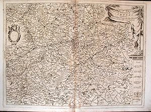
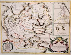
Genovesato parte occidentale.
Edité par Artist: Coronelli Vicenzo Maria ( - 1718 ) Venice; issued in: Venice; Coronelli Vicenzo Maria ( 1650 - 1718 ) Venice; Coronelli Vincenzo (1650 ? 1718) He was a cosmographer geographer biographer encyclopedist globe maker inventor and an expert of engeneering and hydraulics Extraordinarily versatile mind and an extremely tireless man he produced more than 140 pieces in different genres At the age of 15 he entered the Franciscan Order which he then guided as Gran Generale from 1699 He became famous as geographer and mathematician awakening the interest in these subjects in Italy at the end of the XVII century, 1650
Vendeur : Antique Sommer& Sapunaru KG, München, Allemagne
Membre d'association : ILAB VDA
Evaluation du vendeur :
Technic: Copper print; colorit: colored; condition: Very good; size (in cm): 44 x 60; Map shows partly Piemont and Liguria from Nice to SavonaHistory: In ancient times, in northern Italy, unlike in southern Italy, there was hardly any Greek colonization. For the Roman Empire, Northern Italy was initially Gallia cisalpina. Since the Middle Ages, northern Italy has been characterized by remarkable trading cities, which, starting from the Veronese Confederation, united in the Lombardenbund against Emperor Barbarossa. At that time, some basics of business administration and banking, such as double-entry bookkeeping, were created in northern Italy. In pre-Roman centuries it was inhabited by different peoples among whom the Ligures, the ancient Veneti, who prospered through their trade in amber and breeding of horses, the Etruscans, who colonized Northern Italy from Tuscany, founded the city of Bologna and spread the use of writing; later, starting from the 5th century BC, the area was invaded by Celtic ? Gallic tribes. These people founded several cities like Turin and Milan and extended their rule from the Alps to the Adriatic Sea. Their development was halted by the Roman expansion in the Po Valley from the 3rd century BC onwards. After centuries of struggle, in 194 BC the entire area of what is now Northern Italy became a Roman province with the name of Gallia Cisalpina ("Gaul on the inner side (with respect to Rome) of the Alps"). The Roman culture and language overwhelmed the former civilization in the following years, and Northern Italy became one of the most developed and rich areas of the western half of the empire with the construction of a wide array of roads and the development of agriculture and trade. After the fall of the Western Empire, Northern Italy suffered heavily from destruction brought about by migration from Germanic peoples and from the Gothic War. In the 10th century Northern Italy was formally under the rule of the Holy Roman Empire but was in fact divided in a multiplicity of small, autonomous city-states, the medieval communes and maritime republic. The 11th century marked a significant boom in Northern Italy's economy, due to improved trading and agricultural innovations, culture flourished as well with many universities founded, among them the University of Bologna, the oldest university in Europe. In the end a balance of power was reached in 1454 with the Peace of Lodi and Northern Italy ended up divided between a small number of regional states, the most powerful were the Duchies of Savoy, Milan, Mantua, Ferrara and the Republics of Genoa and Venice, which had begun to extend its influence in the mainland from the 14th century onwards. In the 15th century Northern Italy became one of the centres of the Renaissance whose culture and works of art were highly regarded. After the French Revolution in the late 18th century Northern Italy was conquered by the French armies, many client republics were created by Napoleon and in 1805 a new Kingdom of Italy, made of all of Northern Italy but Piedmont that was annexed to France, was established with Milan as capital and Napoleon as head of state. In the congress of Vienna, the Kingdom of Sardinia was restored, and furthermore enlarged by annexing the Republic of Genoa to strengthen it as a barrier against France. The rest of Northern Italy was under Austrian rule, either direct like in the Lombardo-Venetian Kingdom or indirect like in the Duchies of Parma and Modena. Bologna and Romagna were given to the Papal State.