
Montant total (1 article articles) :
Destination de la commande :

DON JOSEPH DEL RIO (1 résultats)
Passer aux résultats principaux de la recherche
Type d'article
- Tous les types d'articles
- Livres
- Magazines & Périodiques
- Bandes dessinées
- Partitions de musique
- Art, Affiches et Gravures
- Photographies
- Cartes (1)
-
Manuscrits &
Papiers anciens
Etat
- Tous
- Neuf
- Ancien ou d'occasion
Reliure
- Toutes
- Couverture rigide
- Couverture souple
Particularités
- Edition originale
- Signé
- Jaquette
- Avec images
- Sans impression ŕ la demande
Pays
Evaluation du vendeur
-
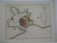
Plan of the Harbour and City of the Havana
Edité par Chart Committee of the Admiralty c. 1844, London, 1844
Vendeur : Alexandre Antique Prints, Maps & Books, Toronto, ON, Canada
Membre d'association : ABAC ILAB
Evaluation du vendeur :

Carte
Originally printed in 1798 in Spanish, later translated by Faden in 1804 and again in 1844. Hydrographic Office seal in top right. The bay is marked with depth soundings. In the upper right of the map is a legend denoting various landmarks and edifices on the map., Size : 446x551 (mm), 17.56x21.69 (Inches), Hand Colored, 0 Very Good; four small tears in the upper right, right, and lower right margin, professionally repaired and not affecting the image.