Montant total (1 article articles) :
Destination de la commande :

FADEN, W ILLIAM (2 résultats)
Passer aux résultats principaux de la recherche
Type d'article
- Tous les types d'articles
- Livres (1)
- Magazines & Périodiques
- Bandes dessinées
- Partitions de musique
- Art, Affiches et Gravures
- Photographies
- Cartes (1)
-
Manuscrits &
Papiers anciens
Etat
- Tous
- Neuf
- Ancien ou d'occasion
Reliure
- Toutes
- Couverture rigide (1)
- Couverture souple
Particularités
- Edition originale
- Signé
- Jaquette
- Avec images
- Sans impression ŕ la demande
Pays
Evaluation du vendeur
-
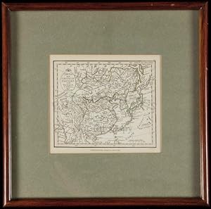
Hardcover. Etat : Fine. Description: Copper-engraved map, slight hand-coloring in outline. sight 10 x 11.5 cm. (4" x 4 1/2"), matted and framed 23.5 x 23.5 cm (9 1/4" x (1/4") under plexiglass. Charming little map of easter Asia. Lat 18th century Eastern Asiatic map of China, Corea and Japan produced during the reign of Emperor Jiaqing. The title is engraved on shield in the upper left hand corner. Condition: Fine; not examined out of frame.
-
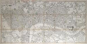
A Plan of London and Westminster With The Borough Of Southwark.
Edité par LondonW. Faden. Charing Cross. Jany., 1821
Vendeur : Robert Frew Ltd. ABA ILAB, London, Royaume-Uni
Membre d'association : ABA ILAB PBFA
Evaluation du vendeur :

Carte
Overall dimensions 47.x 92 cm. Original colour, mostly in outline but also in block to the squares. A detailed and well executed folding plan of London showing the extents from Islington to Newington and Stepney to Hyde Park. The plan dissected into 24 sections and backed on to linen. Folds into original orange-brown marbled paper card slipcase, small publisher's labels pasted on upper board . Identical publisher's label to verso of one of the end sections, matchhing marbled paper tabs on the verso of both end sections. The slipcase worn at extremities, otherwise sound. Some ink stains to linen backing, but not affecting the recto of the plan. A few spots to centre of image, though the plan generally very clean and in very good condition. Cf Howgego, No. 269 for 1817 edition, no 1821 edition listed.