Montant total (1 article articles) :
Destination de la commande :

GERARD VAN KEULEN (26 résultats)
Passer aux résultats principaux de la recherche
Type d'article
- Tous les types d'articles
- Livres (14)
- Magazines & Périodiques
- Bandes dessinées
- Partitions de musique
- Art, Affiches et Gravures (5)
- Photographies
- Cartes (7)
-
Manuscrits &
Papiers anciens
Etat
- Tous
- Neuf
- Ancien ou d'occasion
Reliure
Particularités
- Edition originale (2)
- Signé
- Jaquette (1)
- Avec images (19)
- Sans impression ŕ la demande
Pays
Evaluation du vendeur
-
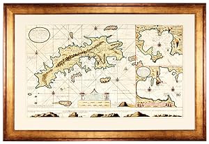
2 "Hempel" reprints: Carte de la Nouvelle France / Carte de Curaçao
Edité par Hempel Peintures Marine France S.A. Paris. c., 1990
Vendeur : Jean-Louis Boglio Maritime Books, CYGNET, TAS, Australie
Membre d'association : ANZAAB ILAB
Evaluation du vendeur :

2 frameable charts. Reprints from the 1734 original by Gérard Van Keulen, published in 1734 in "Lichtende Zee-Fackel" in Amsterdam, and held at "La Biblothčque Royale, Copenhague, Danemark". Oblong format: 31 x 35.5. Nouvelle France: Canada and Louisiana- Curaçao, Netherland West Indies.
-

De Nieuve Groote Ligtende Zee-Fakkel.
Edité par 1969-1970, 1969
Vendeur : Berkelouw Rare Books, Berrima, NSW, Australie
Membre d'association : ANZAAB ILAB
Evaluation du vendeur :

Amsterdam 1716-1753. Reprinted, New York: Da Capo Press & Amsterdam: Theatrum Orbis Terrarum, (1969-1970). 6 parts in 3 vols. Elephant folio. Orig. cloth. Gilt. Spines uniformly gilt with raised bands and morocco titling-labels (slightly rubbed). With illusts., fold. map & charts some of which are coloured. Peel marks on end-papers. Complete and as new, albeit ex-library with stamps on edge of text-block. Lim. ed. of 500 numbered sets.
-
De nieuwe groote ligtende zee-fakkel: Amsterdam 1716-1753 (2 volumes)
Edité par Amsterdam : Theatrum Orbis Terrarum, 1969
Livre
Etat : Good. 2 (of 3) uniform gilt lettered brown leatherette volumes, (foldanle) maps in b/w, large folio. Limited edition of 500 numbered copies, however, this is an unnumbered copy.; Edges covers lsightly worn.
-
De Groote nieuwe vermeerderede Zee-Atlas ofte Water-Waereld. Frontispiece only. Very rare. Single leaf.
Edité par [Gerard van Keulen,] [1708]., [Amsterdam:], 1708
Vendeur : Dark Parks Books & Collectibles, Fallon, NV, Etats-Unis
Evaluation du vendeur :
Original frontispiece to the van Kuelen masterpiece sea-atlas De Groote Nieuwe Vermeerderede Zee-Atlas ofte Water-Waereld. Vertoonende in zig alle de Zee-kusten des Aardryks. [Amsterdam, 1708]. Leaf has been adhered at corners to another sheet. Trimmed at border line with some minor edge wear and soiling. Beautiful illustration and most suitable for framing. We find only one copy in reference, which was sold at Christie?s UK for over $200,000.00 at auction in May, 2022. The frontispiece is a match at all points, though trimmed and uncolored [the Christie?s copy full and in color]. ?The most complete sea-atlas by the Van Keulens, composed of nearly all the charts published up to the date 1709? [-Koeman].?The firm of van Keulen, active continuously from 1678 to 1885, was the largest private hydrographic chart-publishing agency in the world. Three generations of the family were active during the period when Amsterdam was at its height as a mercantile and shipping power. As a by-product of this, Amsterdam became the leading European centre of marine cartography, densely populated with the best chart-makers and publishers. Pre-eminent among these firms were the van Keulens who produced ?the largest and finest marine atlases in Holland? (Koeman). ?Johannes van Keulen (1654-1711) was the founder of the firm, enrolling in the booksellers? guild in Amsterdam in 1678. In 1680 he published the first part of his Zee-Atlas, by which the reputation of the firm was established. Although the family business was closely tied to maritime publications, Johannes himself was not a chart-maker, but simply an interested publisher. He was fortunate that, from the outset, he employed the skilled surveyor Claes Janszoon Vooght, who actually prepared the charts and also wrote the text. Over the years the Zee-Atlas was expanded to five parts, and it continued in print, in one form or another, until 1734. More ambitious, and with a far longer and more complicated history, was his pilot book, the Zee-Fakkel, which was first published in 1681-82, and continued in print to about 1800. The family also published books on every aspect of geography, navigation and nautical matters. Johannes?s son Gerard (c. 1678-1727) gradually succeeded him from about 1704. In contrast to his father, Gerard was a talented engraver, mathematician, and chart-maker, whose abilities were recognised when he was appointed Hydrographer to the Dutch East India Company in 1714. Under his guidance, the Zee-Atlas and Zee-Fakkel were greatly revised and improved, and many new charts introduced. After Gerard?s relatively early death in 1727, he was succeeded by his widow and later by his son Johannes II who is known in particular for publishing the sixth volume of the Zee-Fakkel ? this volume contained the previously secret cartography of the East India Archipelago.? [Christie?s lot 8, May 24, 2022].
-
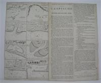
Korte Beschryvinge van de Caspische
Edité par Amsterdam, 1722
Vendeur : Alexandre Antique Prints, Maps & Books, Toronto, ON, Canada
Membre d'association : ABAC ILAB
Evaluation du vendeur :

Carte
Etat : Very good. A rare series of maps of various Caspian Ports by Van Keulen., Size : 510x600 (mm), 20.125x23.625 (Inches), Black & White.
-
![Image du vendeur pour A NEW GRAD[U]ALLY ENCREASING COMPASS-MAP OF THE COMING IN OF THE CHANNEL, OR THE HEADS; CONTAINING A PART OF THE COAST OF BOULONNOIS; EXTENDING FROM CALLIS TO DANNES, AS ALSO IN ENGLAND, FROM THE SOUTH FORLAND TO RYE WITH THEIR SHALLOWNESSES AND DEPTHS BY N. DE VRIES. (This is an exact transcription of the title in English. The same title is also in Dutch and French) mis en vente par Marrins Bookshop](https://pictures.abebooks.com/inventory/md/md8565327562.jpg)
A NEW GRAD[U]ALLY ENCREASING COMPASS-MAP OF THE COMING IN OF THE CHANNEL, OR THE HEADS; CONTAINING A PART OF THE COAST OF BOULONNOIS; EXTENDING FROM CALLIS TO DANNES, AS ALSO IN ENGLAND, FROM THE SOUTH FORLAND TO RYE WITH THEIR SHALLOWNESSES AND DEPTHS BY N. DE VRIES. (This is an exact transcription of the title in English. The same title is also in Dutch and French)
Edité par G. Van Keulen, Amsterdam. n.d. but c.1695, 1695
Vendeur : Marrins Bookshop, Folkestone, KENT, Royaume-Uni
Membre d'association : ABA ILAB PBFA
Evaluation du vendeur :
Large hand-coloured copper-engraved sea chart, 20.5 x 23.5 inches. Traces of old fold otherwise the condition is very good with attractive colours and quality paper. An attractive and decorative sea chart of the English Channel centred on the Varne sand banks, with the coast of Kent from South Foreland to Rye and the French coast from Calais to just south of Boulogne. Navigational features on the land are marked - churches, castles and lighthouses etc. The sand banks are marked complete with sea depths, safe anchorage etc., rhumb lines and compass rose and an attractive cartouche. A rare chart produced by the successful Van Keulen firm. Their charts are scarce in England as the English were frequently at war with the Dutch during the heyday of their production. JOHANNES VAN KEULEN 1654-1711 - GERARD VAN KEULEN 1678-c.1727 The Dutch produced a remarkable number of enterprising and prolific map and chart makers but not even the Blaeu and Jansson establishments could rival the vigour of the van Keulen family whose business was founded in 1680 and continued under their name until 1823 The firm was founded by Johannes van Keulen who was registered as a bookseller in Amsterdam in 1678. In 1680 he published the first part of his Zee Atlas which, over the years, was expanded to 5 volumes and continued in one form or another until 1734. More ambitious and with a far longer and more complicated life was his book of sea charts, the Zee-Fakkel, published in 1681-82 Although the firm was founded by Johannes van Keulen, he was primarily a publisher; it was his son, Gerard, a talented engraver and mathematician, Hydrographer to the East India Company, who became the mainspring of the business, which not only published charts but also books on every aspect of geography, navigation and nautical matters. The title of the map is in lower case script and for some reason the engraver inverted the 'u' in Gradually so that it reads Gradnally PRINTS/MAPS SEA CHARTS PRINTS/MAPS.
-
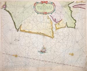
De Cust van Portugael Het Uzydlyckste deel, Beginnende van Pißage tot aen S. Vues alias Setubal.
Edité par Artist: Keulen Gerard van ( - 1726 ) Amsterdam; issued in: Amsterdam; Keulen Gerard van ( 1678 - 1726 ) Amsterdam; Gerard van Keulen (Amsterdam 1678 ? 1726) He was a dutch carthographer publisher and book dealer He was the son of Johannes van Keulen Johannes van Keulen (1654 - 1715) was a 17th-century Dutch cartographer He published the influential nautical atlas the Zee-Atlas and the pilot guide Zee-Fakkel In 1678 Johannes van Keulen established himself in Amsterdam and in 1680 he obtained a patent from the States of Holland and West Friesland allowing him to print and publish maritime atlases and shipping guides These were books of maps and descriptions of itineraries used by helmsmen for safe navigation The patent was a kind of protectio, 1678
Vendeur : Antique Sommer& Sapunaru KG, München, Allemagne
Membre d'association : ILAB VDA
Evaluation du vendeur :
Technic: Copper print; colorit: colored; condition: Perfect condition; size (in cm): 42 x 51,5 cm; Map shows the Atlantic coast of Portugal with Lisbon, two wind roses and a sailing ship. History: Portugal is the oldest state on the Iberian Peninsula and one of the oldest in Europe, its territory having been continuously settled, invaded and fought over since prehistoric times. The pre-Celtic people, Celts, Carthaginians and Romans were followed by the invasions of the Visigoths and Suebi Germanic peoples. In the 15th and 16th centuries, Portugal established the first global empire, becoming one of the world's major economic, political and military powers. During this period, today referred to as the Age of Discovery, Portuguese explorers pioneered maritime exploration, notably under royal patronage of Prince Henry the Navigator and King John II, with such notable voyages as Bartolomeu Dias' sailing beyond the Cape of Good Hope (1488), Vasco da Gama's discovery of the sea route to India (1497?98) and the European discovery of Brazil (1500). During this time Portugal monopolized the spice trade, divided the world into hemispheres of dominion with Castille, and the empire expanded with military campaigns in Asia. However, events such as the 1755 Lisbon earthquake, the country's occupation during the Napoleonic Wars, the independence of Brazil (1822), and a late industrialization compared to other European powers, erased to a great extent Portugal's prior opulence.
-
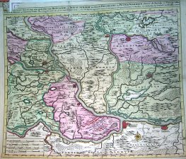
Nieuwe Accurate Kaert van een gedeelte van Hongarie en Donau Stroom Vertonende Belgrado en Peter Wardein alwaer de Batalje is Voor.Kyser en Groote Turk, den 5 Augustius 1716.stad Temeswar un door den Kyser.Provintien en Steeden. (Balcanes)
Edité par Amsterdam, 1716
Art / Affiche / Gravure
Etat : ACEPTABLE. Tot Amsterdam by Gerard van Keulen et Privel Falta de papel en esquina superior y en margen inferior.izquierda. Formato (cm): 61x51.
-
Etat : ACEPTABLE. Restaurado Los barcos de la parte central son dibujos originales Muy raro Formato (cm): 54x42.
-
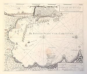
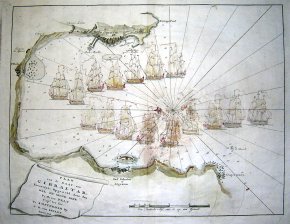
De Baayen Stadt van Gibralter.
Edité par Amsterdam,, 1680
Vendeur : libreria antiquaria perini Sas di Perini, Verona, VR, Italie
Membre d'association : ALAI ILAB
Evaluation du vendeur :
Art / Affiche / Gravure
Incisione in rame, mm 520x620. Splendido esemplare su carta forte che raffigura la baia di Gibilterra durante l'assedio da parte del vice ammiraglio George Rooks fra agosto 1704 e febbraio 1705, terminato con la conquista della citt? da parte degli inglesi. Decorata da rose dei venti e navi che assediano, di ognuna delle quali Ë indicato il nome del comandante. Gerard van Keulen (1678-1727) Ë figlio di Johannes (1653-1715) celebre editore di atlanti nautici, dopo Waghenaer forse il pi? importante, anche perchË la sua ampia produzione coprĎ tutto il mondo. Ampi margini. Un lievissimo alone in basso. Nr.cat: P2121245.
-
De nieuwe groote lichtende Zee-Fakkel, van de geheele wereld: behelzende 't eerste, 't tweede, 't derde, 'tvierde, en vyfde deel : alwaar klaar en volkomen in vertoond werd, alle bekende zeekusten van de geheele wereld, . vergadert met groote kosten, en op het nieuw in beter order gesteld als voor deese, en verrykt met het vyfde of laatste deel, dat nooyt voor dese in 't licht is geweest / te samen gebracht door Claes Jansz. Vooght en Gerard van Keulen. [COMPLETE SET].
Vendeur : Antiquariaat A. Kok & Zn. B.V., Amsterdam, Pays-Bas
Membre d'association : ILAB NVVA
Evaluation du vendeur :
Amst., 1716-1753 [reprint Amst. & N.Y., 1969-1970]. 6 parts in 3 vols. [10],100,[50], [6],51,[43], [8],76,[16]pp., 252 (fold.) col. & b./w. maps. Dec. gilt tooled and raised imit. calf (rexine) bindings. Folio. - Spines damaged. along the extrimities; title vignets on spine sl. dam. (Theatrum Orbis Terrarum).Facsimile reprint of the edition Amst., 1716-1753, published in a limited edition of 500 numbered copies. With reprint of the text of the French edition (Amst., 1715) bound with at the end of the third volume. - - Complete set of 6 parts in three volumes: Part I: Vertoonende de zee-kusten van Holland . / vergadert door Claas Jansz. Voogt ; . met veele nieuwe kaarten . door Gerard van Keulen; part II: Verthoonende de zeekusten van het zuyderste gedeelte van de Noord-Zee . / verb. door Claas Jansz. Voogt ; en deze laatste druk vermeerdert en in 't ligt gebragt / door Joannes van Keulen; part III: Vertoonende de kusten van Granada . / verbetert door Claas Jansz. Voogt ; en deze laatste druk nieuwelyks verbeterd . door Gerard van Keulen; part IV: Verthoonende de zeekusten van Gujana . / door Claas Jansz. Vooght; part V: Vertoonende de zee-kusten van Guinea . / verbetert door Claes Jansz. Voogt ; en deze laatste druk nieuwelyks verb. . door Gerard van Keulen; part VI: Vertoonende de zeekusten, eylanden en havens van Oost-Indien . / alles . by eengebragt . door Jan de Marre ; met de nodige kaarten en landvertooningen verrykt en in 't licht gebragt door Joannes van Keulen.
-
Sterre Kaert of Hemels Pleyn, Waer Door Men Kanwetehoelaet Dat Hetis Overde Gehele Aertkloot, Op Alle Meridiane en Polus Hoogte, en, Opwat Lengte en Brete de Voorsz Sterre Staen, Bezuyde en Benoorde de Lini quinoctiael
Edité par Amsterdam, Reinier & Josua Ottens, 1750 circa, 1750
Vendeur : TABERNA LIBRARIA - ALAI - ILAB, Pistoia, Italie
Membre d'association : ALAI ILAB
Evaluation du vendeur :
Grande tavola incisa in rame, mm. 470x595 alla battuta (compresi margini bianchi mm. 540x625) impreziosita da coloritura coeva all'acquerello. Considerata una fra le tavole olandesi piů belle, di argomento astronomico. Incise le costellazioni settentrionali e gli emisferi meridionali in una sola proiezione. Le costellazioni sono raffigurate con i personaggi della mitologia classica, rappresentati come se guardassero la terra dall'alto, peraltro, con le loro schiene girate. Al margine inf. č presente una tabella di misurazioni organizzata in base ai segni zodiacali. Magnifica, antichi restauri al verso, nel punto di piega e una vecchia giunta in carta al margine inf. Molto rara.
-
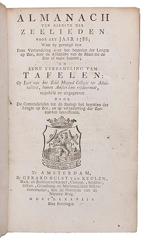
Almanach ten dienste der zeelieden voor het jaar 1788.Including:(2) Over het bepalen der lengte op zee door de afstanden van de maan tot de zon, of vaste sterren, .(3) Van tafelen, ten dienste der zeelieden, en voor al ter bevordering van het bepaalen der lengte op zee, door de afstanden van de maan tot de zon, of de vaste sterren; .Amsterdam, Gerard Hulst van Keulen, 1787-1788. 3 parts in 1 volume. 8vo. With three title-pages with woodcut printer's device, mathematical figures in the text, letterpress tables, and 4 large printed folding tables. Contemporary half vellum.
Vendeur : ASHER Rare Books, T Goy Houten, Pays-Bas
Membre d'association : ILAB NVVA
Evaluation du vendeur :
XXX, 108, 87, [1]; XXIII, 136; [4], 30, [2], 60 pp.First edition of an almanac for the use of seamen, in three parts, published by order of the board of the Amsterdam Admiralty by the Committee for the establishment of longitude at sea and the improvement of nautical charts, in which committee Van Swinden played a leading role. The almanac is based on the English Nautical almanac and includes everything that can be of use to seamen, including a separate part on the calculation of longitude at sea and a part with letterpress tables necessary for the calculations. Although John Harrison had already demonstrated the accuracy of his chronometer in the 1760s they were still not in widespread use and the present works calculate longitude from very precise measurements of the position of the moon.In very good condition, only slightly browned around the margins. Binding worn along the extremities, sides chafed but otherwise good.l Bierens de Haan, 4789 (1), 4791 (2), 4793 (3); C.A. Davids, Zeewezen en wetenschap, pp. 188-190; Poggendorf II, col. 1058.
-
Nouvelle Carte de la Riviere de Canada ou St Laurens de l'Isle de Anticoste Jusqua Quebec, Dans le Partie d'Amerique la Plus Septentrionale
Edité par c. 1720, France, 1720
Vendeur : Alexandre Antique Prints, Maps & Books, Toronto, ON, Canada
Membre d'association : ABAC ILAB
Evaluation du vendeur :
Carte
Etat : Very Good. A handsome and detailed early map of Quebec, centered on the St Lawrence River. Inset views of Pointe aux Alouette, Les Sept Isles, Isle D'Orleans, and a view of upstream St Lawrence river. , Size : 516x594 (mm), 20.31x23.39 (Inches), Hand Colored.
-
Pas-Kaart Vande Rivieren - Commewini Suriname Suramaca Cupanama en Courantin Vertoonende Alle Desselts Plantagie en Wie Deselive Bezitten Alles opt Naukeurigste Opgestelt. Tot Amsterdam by Gerard Van Keulen Boek en Zeekaert Verkoeper An de Niewen Brug op de Hoek Van de Nieuwen Brug Steegh in de Gekroonde Lootsman met Previlegie.
Edité par v. Keulen Gerard 1700-80, Amsterdam, 1700
Vendeur : Antiquariat Reinhold Berg eK Inh. R.Berg, Regensburg, Allemagne
Membre d'association : ILAB VDA
Evaluation du vendeur :
Carte
Other. Original antique copper engraving, later hand colored. In excellent condition. 515 by 880mm (20 by 34 inches). 515 by 880mm (20 by 34 inches).
-

Kolorierter Kupferstich - Afteekening van de Rivier of Haven van Calingfort - Yrland - Down County - Part of Dublin County in Irland - Dublin Harbor - Dublin Bay - Doppelkarte von Dublin und Carlingford - Irland. Seekarte.
Edité par Amsterdam ca 1750., 1750
Carte
ca 52 x 31 cm. Etat : Gut. Erstauflage, EA. 1 Blatt in sehr schönem Rahmen gerahmt hinter Glas mit Passepartout, ohne Rahmen ca 52 x 31 cm, miot Rahmen 81 x 63 cm, guter Zustand Sprache: Deutsch Gewicht in Gramm: 1100.
-
Curacao, From the Dutch Originals of Gerard Van Keulen, Reglated by Astrono9inset 9mical Observations.
Edité par Robert Sayer, London, 1775
Vendeur : Arader Galleries of Philadelphia, PA, Philadelphia, PA, Etats-Unis
Evaluation du vendeur :
Livre
N/A. Etat : Very Good. Etat de la jaquette : N/A. Engraving with superb original hand-color. Red sealinng wax at upper right border. London. Printed for Robt. Sayer. Map and Printsller No. 53 in Fleet Street as the Act directs 20 Feby. 1775. Sheet size: 20 3/4 x 28 1/2". Frame size: 25 7/8 x 33 3/8".
-

Nieuwe Afteekening van het Eyland en Koninkryk Sicilia
Edité par Artist: Keulen Gerard van ( - 1726 ) Amsterdam; issued in: Amsterdam; Keulen Gerard van ( 1678 - 1726 ) Amsterdam; Gerard van Keulen (Amsterdam 1678 ? 1726) He was a dutch carthographer publisher and book dealer He was the son of Johannes van Keulen Johannes van Keulen (1654 - 1715) was a 17th-century Dutch cartographer He published the influential nautical atlas the Zee-Atlas and the pilot guide Zee-Fakkel In 1678 Johannes van Keulen established himself in Amsterdam and in 1680 he obtained a patent from the States of Holland and West Friesland allowing him to print and publish maritime atlases and shipping guides These were books of maps and descriptions of itineraries used by helmsmen for safe navigation The patent was a kind of protectio, 1678
Vendeur : Antique Sommer& Sapunaru KG, München, Allemagne
Membre d'association : ILAB VDA
Evaluation du vendeur :
Technic: Copper print; colorit: colored; condition: Some folds and tears perfectly set down; size (in cm): 50 x 89 cm; Rare map of Sicily with the mount Etna, the southern part of Itlay with the Reggio Calabria and decorative ships representation, windrose and coat of arm of the royal kingdom of Sicily. 9 maps on 1 sheet: big mal of Sicily, and 8 other maps showing the cities of Palermo, Messina, Augusta, Sergento, Trapani, Milazzo, Catania and the mount Ettna and Napoli. History: The central location of Sicily in the Mediterranean Sea has shaped the eventful history of this island. As bases for seafaring and trade, the cities of Sicily have always had great importance. Time and again, therefore, new conquerors seized the island, stayed, mixed with the already resident population and left their mark on the culture of Sicily. Only rarely was the island politically independent, mostly it was ruled by empires or states that had their political center elsewhere. From about 800 B.C. began the period of colonization by Phoenicians, mainly from the Phoenician planting city of Carthage, and somewhat later by Greeks, for whom Sicily became part of Greater Greece. In 264 BC, a Roman army crossed into Sicily, triggering a war with the Carthaginians that resulted in heavy losses. By late antiquity, Sicily was largely Romanized. After the fall of the Western Roman Empire in the late 5th century, Sicily was first dominated by the Vandals and Ostrogoths and became part of the Eastern Roman-Byzantine Empire in the mid-6th century. The first attempt at Christian reconquest of the island was still a Byzantine initiative; the imperial commander Georgios Maniakes conquered Messina in 1038 and Syracuse in 1040. Now Sicily experienced another period of prosperity and became an independent kingdom in 1130. A symbiosis of Byzantine, Arab and Norman traditions produced many important works of art. Thereafter, Sicily again fell under the control of other powers: Aragon, Spain, Savoy and Austria followed one another. With the unification of Italy, which began with Garibaldi's invasion of Sicily, Sicily became part of the new Kingdom of Italy in 1861.
-
![Image du vendeur pour Amstelodami veteris et novissimi delineatio per Jacobum de la Feuille [latest depiction of old Amsterdam by Jacob de la Feuille] mis en vente par Inter-Antiquariaat Mefferdt & De Jonge](https://pictures.abebooks.com/inventory/md/md31378411498.jpg)
Amstelodami veteris et novissimi delineatio per Jacobum de la Feuille [latest depiction of old Amsterdam by Jacob de la Feuille]
Vendeur : Inter-Antiquariaat Mefferdt & De Jonge, Amsterdam, Pays-Bas
Membre d'association : ILAB NVVA
Evaluation du vendeur :
Art / Affiche / Gravure Edition originale
Amstelodami veteris et novissimi delineatio per Jacobum de la Feuille [latest depiction of old Amsterdam by Jacob de la Feuille]. Copper engraving first published in 1678 by Johannes de Ram, here in an edition by Gerard van Keulen from around 1725. Coloured by a later hand. Size: 48 x 56 cm. Engraver and publisher Johannes de Ram (1648-1693) regularly copied work by others. For the map image, he took a 15-year-old map by Nicolaes Visscher as an example. He copied the city panorama, the decorations in the bottom left and right corners and the idea of the imperial crown (on the city coat of arms) and city seal from a map by rival Frederik de Wit. De Ram added a pair of putti himself. After the first edition, the map image was updated. Among other things, the garden behind the Besjeshuis on the Amstel [today's Hermitage Amsterdam] was added. That building was completed in 1683 and the garden was laid out afterwards. Weesperstraat appears to have been built on both sides and the Plantage has its garden structure. The islands of Uilenburg and Marken are also fully built. The area outside the Singelgracht around the northernmost bastions of Zeeburg and Leeuwenburg was engraved in more detail. Changes were also made to the rows of pilings in the IJ, and were given names. Between Rapenburgergracht and Nieuwe Vaart, houses and shipyards were added. After the death of Johannes de Ram in 1693, Jacob de la Feuille, who himself continued the business until his death in 1719, married De Ram's widow. He reissued the map, replacing De Ram's name in the title strip for his own. Finally, the map came into the hands of yet another publisher, Gerard van Keulen, who marketed it again around 1725. Literature: Marc Hameleers "Kaarten van Amsterdam 1538-1865", no. 79-4. Price: Euro 2.850,-.
-
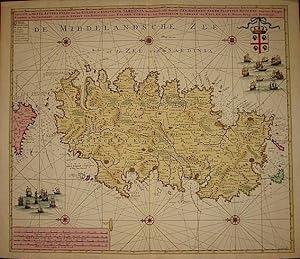
Nieuwe en nette afteekening van et Eyland of Koninkryk Sardinia.
Edité par Amsterdam 1720 ca., 1720
Vendeur : Libreria Ex Libris ALAI-ILAB/LILA member, Roma, Italie
Membre d'association : ALAI ILAB
Evaluation du vendeur :
Carte
Incisione originale su rame (cm. 58x51 piů ampi margini bianchi). Splendida coloritura coeva all'acquarello. Esemplare in eccellente stato di conservazione. Rara.
-
HAVANA, CUBA: De Stad en Haven van Havana op't E˙land Cuba met alle Desselfs Droogtens en Dieptens.
Edité par Amsterdam: Johannes van Keulen [Gerard Hulst van Keulen, circa ]., 1780
Vendeur : Antiquariat Dasa Pahor GbR, München, Allemagne
Membre d'association : ILAB VDA
Evaluation du vendeur :
Carte
Copper engraving, contemporary guard mounted to centrefold verso (Very Good, clean and attractive, just some stains in blank margins), 53 x 65 cm (21 x 25.5 inches). One of the rarest and most attractive of the great historical sea charts of Havana Harbour, and one which grants a fine rendering of the cityscape of what was then the New World s most sophisticated metropolis; first published in the mid-18th century by the eminent Amsterdam cartographer Johannes Van Keulen II, but here with the plate re-employed around 1780 by his son, Gerard Hulst van Keulen, the last major principal of the legendary Van Keulen publishing dynasty. - This very rare chart of Havana Harbour was first issued by Johannes van Keulen, the scion of the legendary Amsterdam chairmaking dynasty, around 1750, and was reissued (without changes to the plate) about three decades later by his son, Gerard Hulst van Keulen. One of the most attractive of historical charts of the subject, it provides a fine rendering of the city of Havana proper. Havana s stellar natural harbour is shown to expand into a great basin beyond its narrow mouth, which connect it to the Straits of Florida. The waters feature numerous bathymetric soundings, while the great walled city occupies the peninsula to the northwest of the port. Havana, founded in 1513, had for over two centuries been the great marshalling point for the Flotas, the annual fleets of Spanish galleons that carried vast quantities of silver and gold from South America and Mexico to Spain. This role, plus Cuba s immensely lucrative sugar-slave economy, had made Havana one of the wealthiest and arguably the most culturally sophisticated city in the New World. Its streets and great plazas were lined with immensely grand and elaborately decorative buildings that would have held pride of place in any European capital. The city of Havana is shown to be surrounded by its old walls and additionally defended by the immense fort of the Castillo de El Morro, at the western side of the moth of the harbour, while across is its sister bastion, the Castello de La Punta, while the Castello de La Fuerza protects Havana s quayside. Within the city, the key, in the lower left, employs letters to identify 22 sites, labelled (A-Z) with the first 16 entries on the list (A-Q) noting Havana s many grand ecclesiastical edifices, including A. Cathedral, as well as convents / monasteries and parish churches. Secular sites include the R. Audit Office (where gold and silver was inventoried!); S. St. Elmo s Redoubt; T. Infantry Barracks; X. Main City Gate; and Z. Abattoir. The surrounding countryside assumes a bucolic appearance, with rolling hills, forests and arroyos, punctuated by roads and the odd rural church. SEE OUR WEB PAGE FOR A LONGER DESCRIPTION.
-
Spaanse Zee Vant Kanaal tot 't Eyland Cuba in Westindia.
Edité par c.1720, Amsterdam, 1720
Vendeur : Alexandre Antique Prints, Maps & Books, Toronto, ON, Canada
Membre d'association : ABAC ILAB
Evaluation du vendeur :
Carte
Size : 607x513 (mm), 23.90x20.20 (Inches), Original Hand Coloring Very Good, backed on acid free tissue paper for long term preservation.
-
NIEUWE EN ALDEREERSTE AFTEEKENING VAN T'EYLAND ST. THOMAS. MET ALLE DESSEFS HAVANEN, ANKER PLAATSE EN GELEEGONT HEDEN, IS GELEEGEN BEOOSTEN I. PORTO RICO IN WEST INDIE.
Edité par [Amsterdam], 1719
Vendeur : William Reese Company - Americana, New Haven, CT, Etats-Unis
Membre d'association : ABAA ESA ILAB SNEAB
Evaluation du vendeur :
Sheet map, 22 1/2 x 38 1/2 inches. Modern color. Handsomely matted and framed. Old fold lines, some minor wear. Very good. Large and handsome chart of St. Thomas, now in the U.S. Virgin Islands but then a Dutch colony, made by the famed Van Keulen cartography firm. This map was originally published as part of a 1720 edition of Van Keulen's DE GROOTE NIEUWE VERMEERDERDE ZEE- ATLAS., a significant work containing one hundred maps and charts (see Phillips). The chart shows the entire island on a very large scale, with its topographical features and harbor depths, as well as the forts and settlements. Two insets on the right show a detailed view of the harbor of St. Thomas and the harbor of the neighboring island of St. John. Along the bottom are five profile elevations, showing the island from different angles. The map is one of the handsomest maps of the island made in the colonial period. Johannes van Keulen enrolled in the Dutch booksellers' guild in 1678 and began publishing sea charts and atlases. That same year his son, Gerard (1678-1726), was born, and he would go on to become a skillful engraver and a significant asset to the firm. "This son was endowed with talent. He was a skillful engraver and proficient in mathematics and navigational science. Gerard was responsible for establishing the scientific basis of the firm of Van Keulen" - Koeman. Gerard van Keulen took over the family business in 1704 and would go on to become the hydrographer for the East India Company in 1714, a prestigious and important office. His son, Johannes, took up the family business upon his death in 1726. PHILLIPS ATLASES 5693. KOEMAN, KEU 31.
-
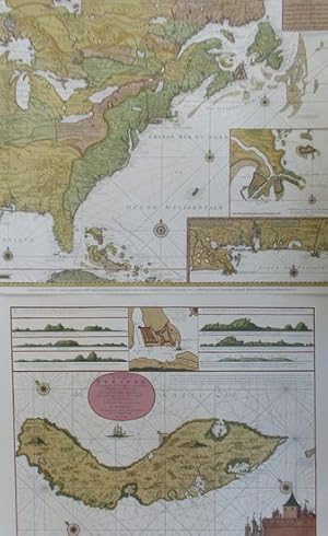
[Untitled Sea-Atlas of the Western Route to the Pacific]
Edité par ca. 1750]., 1750
Vendeur : Maggs Bros. Ltd ABA, ILAB, PBFA, BA, London, Royaume-Uni
Membre d'association : ABA ILAB PBFA
Evaluation du vendeur :
Large Folio (552 x 320 mm); eleven double-page engraved charts, pasted back to back, in original blue paper wrappers pasted to the reverse of the outer charts; original marbled spine. Some light staining, but a reasonable example of the type. [Amsterdam : Gerard van Keulen, Series of scarce sea-charts, engraved on a larger-than-atlas format, clearly assembled to order for shipboard use. The Charts cover the waters from the southern North Sea (notably Amsterdam), through the Channel, the Western approaches to Europe with the Azores and Canary Islands, the Bay of Biscay, coast of Portugal, Mediterranean, the North Atlantic, West Indies, Caribe Islands, south Atlantic and finally the Pacific Ocean. Such compilations are rare.
-
Van Keulen's De Groote Nieuwe Vermeerderde Zee-Atlas ofte Water-Waerld - 183 Originally Hand-colored Maps or Charts
Date d'édition : 1708
Vendeur : Trillium Antique Prints & Rare Books, Franklin, TN, Etats-Unis
Evaluation du vendeur :
Art / Affiche / Gravure
Hardcover. Etat : Fine. This extraordinary and exceedingly rare atlas is from Johannes and Gerard Van Keulen and entitled in full "De Groote Nieuwe Vermeerderde Zee-Atlas ofte Water-Waerld. Vertoonende in zig alle de Zee-Kusten des Aardryks. Bestaande in zeer nette Kaarten, zo platte als wassende Graden: waar in ontdekt zyn alle Baayen, Reeden, Klippen, Droogtens, Dieptens, Anker-plaatzen, en alle Strekkingen en Opdoeningen van Landen: ook haar lengten en Polus hoogten, &c. Dienende tot Opbouwinge en Voortplantinge der Scheepvaart, uit nieuwe Opgevingen van Schippers, Stuurlieden en Liefhebbers der Zeevaart. Te zamen vergaadert en in â t ligt gebragt, door Gerard van Keulen, &c." The work was published in amsterdam by Gerard van Keulen in 1708 (but 1709). --- This was the largest Van Keulen sea atlas ever issued. Keulen atlases of this size are rarely available. The last notable records we see are Sotheby's in 1984 with 160 charts and Christie's in 2019 with 133 charts. --- Johannes van Keulen (1654-1711) was a Dutch publisher. He was said to have produced â the largest and finest marine atlases in Holland.â (Koeman) He received a privelege from the States General of Holland and West Friesland in order to printe maritame atlases and shipping guides. The privilege was to protect his printed material from illegal reproduction. He named his printing firm, In de Gekroonde Lootsman, which grew to be one of the most successful Amsterdam publishing firms. He collaborated with other cartographers including Claes Janszoon Vooght and Johannes van Luyken. --- Keulen's first atlas, entitled "Zee Atlas", contained only 40 charts. By 1695 his atlas would have 160 charts. His son, Gerard, took over publication in 1704 and expanded the atlas to 185 charts by 1709. --- Gerard van Keulen (1678-1727) was a skilled engraver, mathematician, and chart-maker. He was appointed Hydrographer to the Dutch East India Company in 1714. The van Keulen publishing firm operated continuously from 1678 to 1885 with three generations of the family active in the firm. --- The volume is bound in contemporary Dutch calf gilt, covers with a gilt stamped central armillary sphere within an arabesque, spine in compartments with raised bands gilt. --- Present in the atlas: 183 hand-colored engraved plates and charts (nearly all double-page or folding, with the world map credited to Nicolaes Visscher) 14 of which are coastal profiles, Hand-colored engraved allegorical title page or frontispiece dated 1709 (by Aernout Naghtegael after Jan Lukeyn), Folding letterpress title in Dutch dated 1708, Additional title in French dated 1709, 12 pages of Dutch text, 8 pages of French Text, 5 hand-colored allegorical divisional titles dated 1709. --- The contents collates broadly with Koeman Keu 28 (dated 1709 and containing 185 charts), with the following exceptions: the French letterpress title here is dated 1709 rather than 1707; in Part 2 charts (55)+(56) have been joined to form a large folding chart; charts (60) and (61) have been replaced by â Nouvelle carte marine Generale croissant ende-GrĂ s du Canal â ¦ A New General and Gradual increasing Compass Map of the Channel â ¦â ; chart (86) has been replaced with â Paskaert van Cales tot Cadiz â ¦â ; chart (97) has been replaced with â Pascaart van de kust van Portugalâ ; and there is an additional chart after (105) titled â Nieuwe Pascaert vande kust van Maroca en Zanhagaâ ; in Part 3 chart (111) has been updated with â Nieuwe paskaart van tâ opkomender Straat Gibralter â ¦â ; and two pairs of charts have been joined: (126)+(129), and (127)+(128) to form two large folding charts; and in Part 4 (136) has been replaced by â Paskaert waer in de graden der breedde over weder zyden â ¦â . The Dutch letterpress title is dated 1708 and contains the address of Gerard van Keulen, while the general allegorical title and 5 allegorical divisional titles are all dated 1709 and show the address of Johannes van Keulen. A further letterpress.
-
De groote nieuwe vermeerderde Zee-Atlas, ofte Water-Waereld. Vertoonende in zig alle de Zee-Kusten des Aardryks. Bestaande in zeer nette Kaarten, zo platte als wassende Graden: war in ontdekt zyn alle Baayen, Reeden, Klippen, Droogtens, Dieptens, Anker-plaatzen, en alle Strekkingen en Opdoeningen van Landen: ook haar lengten en Polus hoogten, &c. Dienende tot Opbouwinge en Voortplantingte der Scheepvaart, uit nieuwe Opgevingen van Schippers, Stuurlieden en Liefhebbers der Zeevart. Te zamen vergaadert en in't ligt gebragt, door Gerard van Keulen, &c
Edité par By Gerard van Keulen, Amsterdam, 1705
Edition originale
Hardcover. Etat : Very good. First. First Gerard van Keulen edition. Amsterdam: By Gerard van Keulen, 1705-1706[-1709]. Two volumes. Folio (24 1/2" x 15", 622mm x 382mm). Vol. I: folding letterpress Dutch title-page in red and black, privilege, blank, 2pp. letterpress French title, blank. With a hand-colored engraved frontispiece-imprint heightened in gilt and 84 (numbered in manuscript 2-3, 6-8, 10-88) hand-colored engraved folding plates. Vol. II: with a hand-colored engraved frontispiece-imprint heightened in gilt and 79 (numbered in manuscript 1-79) hand-colored engraved folding plates. With 2 hand-colored engraved frontispiece-imprints heightened in gilt, and 163 hand-colored engraved folding plates. Bound in contemporary mottled calf (re-backed with the back-strip laid down). On the boards, two panels bordered by gilt rolls. The inner border has at its outer corners armillary spheres gilt. In the center, Atlas supporting an armillary sphere on his shoulders gilt, surrounded by gilt scrollwork. On the spine, eight raised bands. In the panels, armillary spheres. Title gilt to the second panel, number gilt to the third. All edges of the text-block speckled red. Re-backed, with the back-strip laid down. Front boards splayed (vol. I: ca. 85mm split to the calf). Scuffs and some patches of wear (vol. II: wear to the edges of the front board). Internally, considerable pigment burn (II:21 repairs) and browning of green pigment. Tears to two plates (I:70, II:13). Ink manuscript in an early hand translating the titles of most plates into French. Slips reinforcing the lower edges of the stubs of I:6 with ink manuscript notes, calculations and sketches in an early hand. On the verso of the frontispiece of vol. II, a pencil table (with two entries) titled "Table des Cartes contenues dans ce volume" An exceptionally well-preserved, essentially unsophisticated set. Joannes van Keulen (1654-1715) established in 1679 the firm "de Gekroonde Lootsman", the Crowned Pilot. Mapmaking continued by that firm and family for 200 years; it was one of the great publishing dynasties of Europe. Van Keulen had been augmenting the available stock of charts (and other sorts of atlantean plates: celestial maps, tables of flags, images of ships, coastal views) for 25 years when his son, Gerard, took over the firm. The bookselling innovation of the van Keulen atlases was the offer of an essentially custom collection; one could cobble together what one wanted and could afford. There were over 460 van Keulen charts from which to choose; the largest complement ever found in a single atlas is 185. The present copy boasts 163, the most of any copy in auction records. One plate (I:7) is not listed in Koeman as belonging to any other copy: a French-Dutch table of the world's flags signed by Cornelis Danckerts. The presence of that plate points towards the French ownership of the volume. The insertion of the French title-page is recorded by Koeman in concert with a Dutch title-page (dated 1708), but the combination in the present copy is unrecorded. The numeration and the French titling, the stub-slips (I:6) and the pencil table (II:frontispiece verso) are all in different hands. What the layers of annotation indicate is the engagement the owners and users of the volumes. The first stub-slip queries the angle of the sun and its shadows on the verso; the recto has part of a carefully dotted circle and calculations of degrees. Clearly this was a scrap from the notebook of a French navigator. The Dutch color-expert Dr. Truusje Goedings has written of the present copy that the "volumes have been coloured in the same style but probably not by the same hand. . . With its lavishly gilt title-prints, full colouring of the maps and gilt leather bindings this copy most probably was a de-luxe copy as offered by Van Keulen". Koeman IV: Keu 20B (110 plates overlap) Keu 24 (Dutch title-page, not noting the printing in black-and-red), Keu 25 (French title-page), Keu 28 (135 plates overlap, 1708-9).

![Image du vendeur pour [Untitled Sea-Atlas of the Western Route to the Pacific] mis en vente par Maggs Bros. Ltd ABA, ILAB, PBFA, BA](https://pictures.abebooks.com/inventory/md/md30971882753.jpg)