
Montant total (1 article articles) :
Destination de la commande :

GREENWOOD, C HRISTOPHER & J OHN (14 résultats)
Passer aux résultats principaux de la recherche
Type d'article
- Tous les types d'articles
- Livres
- Magazines & Périodiques
- Bandes dessinées
- Partitions de musique
- Art, Affiches et Gravures
- Photographies
- Cartes (14)
-
Manuscrits &
Papiers anciens
Etat
- Tous
- Neuf
- Ancien ou d'occasion
Reliure
- Toutes
- Couverture rigide
- Couverture souple
Particularités
- Edition originale
- Signé
- Jaquette
- Avec images
- Sans impression ŕ la demande
Pays
Evaluation du vendeur
-
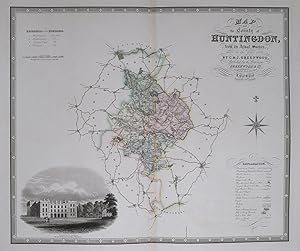
Huntingdonshire. Map of the County of Huntingdon, from an Actual Survey, made in the Year 1829.
Edité par LondonGreenwood & Co. 1834, 1831
Vendeur : Robert Frew Ltd. ABA ILAB, London, Royaume-Uni
Membre d'association : ABA ILAB PBFA
Evaluation du vendeur :

Carte
57 x 68 cm. Orginal colour in block and outline. A very decorative map of the county of Huntingdon with a large vignette view of Kimbolton Castle to the lower left corner. Table of explanation to the lower right and a reference table for the hundreds at the upper left. A very light strip of browning parallel to the centrefold, otherwise in very good condition.
-
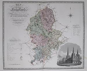
Stafforshire. Map of the County of Stafford, from an Actual Survey made in the Years 1818 & 1819 .
Edité par LondonGreenwood & Co. 1834, 1830
Vendeur : Robert Frew Ltd. ABA ILAB, London, Royaume-Uni
Membre d'association : ABA ILAB PBFA
Evaluation du vendeur :
Carte
58 x 70 cm. Original colour in block and outline. Decorative double page engraved map of the county with a vignette view of Lichfield Cathedral to the lower right corner. Table of explanation and a reference to the hundreds to the left and right edges. Very light brown marks to margins at lower corners, but generally in very good condition.
-
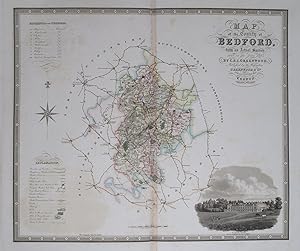
Bedfordshire. Map of the County of Bedford, from an Actual Survey made in the Year 1825 .
Edité par LondonGreenwood & Co., 1834
Vendeur : Robert Frew Ltd. ABA ILAB, London, Royaume-Uni
Membre d'association : ABA ILAB PBFA
Evaluation du vendeur :
Carte
57 x 67.5 cm. Original colour in block and outline. Decorative double page engraved map of the county with a vignette view of Woburn Abbey to the lower right corner. Table of explanation and a reference to the hundreds to the left edge. Light browning along cennterefold, some light offsetting, otherwise in good condition.
-
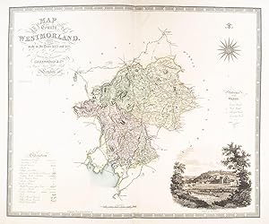
Westmorland. Map of the County of Westmorland, from an Actual Survey made in the Years 1822 & 1823 .
Edité par LondonGreenwood & Co. 1834, 1830
Vendeur : Robert Frew Ltd. ABA ILAB, London, Royaume-Uni
Membre d'association : ABA ILAB PBFA
Evaluation du vendeur :
Carte
58 x 70 cm. Original colour in block and outline. Decorative double page engraved map of the county with a vignette view of Appleby to the lower left corner. Table of explanation and a reference to the wards to the right and left edges. Some light offsetting, otherwise in very good condition.
-
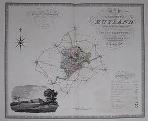
Rutland. Map of the County of Rutland, from an Actual Survey made in the Year 1825 .
Edité par LondonGreenwood & Co. 1834, 1831
Vendeur : Robert Frew Ltd. ABA ILAB, London, Royaume-Uni
Membre d'association : ABA ILAB PBFA
Evaluation du vendeur :
Carte
53.5 x 64.5 cm. Original colour in block and outline. Decorative double page engraved map of the county with a vignette view of Burley House to the lower left corner. Table of explanation and a reference to the hundreds to the lower and upper edges. Some light offsetting, otherwise in very good condition.
-
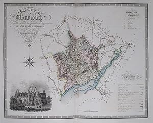
Map of the County of Monmouth, from an Actual Survey made in the Years 1829 & 1830 .
Edité par LondonGreenwood & Co. 1834, 1831
Vendeur : Robert Frew Ltd. ABA ILAB, London, Royaume-Uni
Membre d'association : ABA ILAB PBFA
Evaluation du vendeur :
Carte
55.5 x 70.5 cm. Original colour in block and outline. Decorative double page engraved map of the Monmouthshire with a vignette view of Tintern Abbey to the lower left corner. Table of explanation and a reference to the hundreds to the right edge. Some very faint offsetting, small very light brown patch towards lower edge of centrefold, otherwise in very good condition.
-
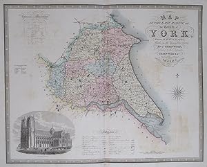
Yorkshire. Map of the East Riding of the County of York, from an Actual Survey made in the Years 1831 & 1832 .
Edité par LondonGreenwood & Co., 1834
Vendeur : Robert Frew Ltd. ABA ILAB, London, Royaume-Uni
Membre d'association : ABA ILAB PBFA
Evaluation du vendeur :
Carte
59 x 74.5 cm. Original colour in block and outline. Decorative double page engraved map of the riding with a vignette view of Beverley Minster to the lower left corner. Table of explanation and a reference to the hundreds to the lower and upper edges. Some offsetting, otherwise in very good condition.
-

Warwickshire. Map of the County of Warwick, from an Actual Survey made in the Year 1821.
Edité par LondonGreenwood & Co. 1834, 1830
Vendeur : Robert Frew Ltd. ABA ILAB, London, Royaume-Uni
Membre d'association : ABA ILAB PBFA
Evaluation du vendeur :
Carte
57.5 x 68 cm. Original colour in block and outline. Decorative double page engraved map of the county with a vignette view of Warwick Castle to the lower left corner. Table of explanation and a reference to the hundreds to the upper left edge. Some light offsetting, otherwise in very good condition.
-
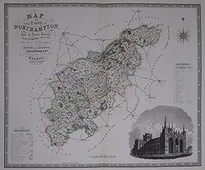
Northamptonshire. Map of the County of Northampton, from an Actual Survey made in the Years 1829 & 1830 .
Edité par LondonGreenwood & Co. 1834, 1831
Vendeur : Robert Frew Ltd. ABA ILAB, London, Royaume-Uni
Membre d'association : ABA ILAB PBFA
Evaluation du vendeur :
Carte
55.5 x 70.5 cm. Original colour in block and outline. Decorative double page engraved map of the Northamptonshire with a vignette view of Peterborough Cathedral to the lower right corner. Table of explanation and a reference to the hundreds to the left and right edges. Generally in very good condition.
-
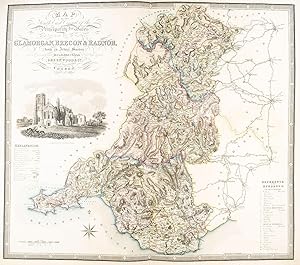
Map of the South East Circuit of the Principality of Wales, Comprising the Counties of Glamorgan, Brecon & Radnor, from an Actual Survey made in the Years 1826 & 1827 .
Edité par LondonGreenwood & Co. 1834, 1831
Vendeur : Robert Frew Ltd. ABA ILAB, London, Royaume-Uni
Membre d'association : ABA ILAB PBFA
Evaluation du vendeur :
Carte
61.5 x 70 cm. Original colour in block and outline. A very decorative double page map of the counties of South East Wales. Large vignette illustration of Llandaff Cathederal to the centre left. Table of explanation and a reference to the county wards to the left and right edges. Some very light offsetting, otherwise in very good condition.
-
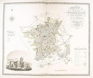
Worcestershire. Map of the County of Worcester, from an Actual Survey made in the Years 1820 & 1821 .
Edité par LondonGreenwood & Co. 1834, 1830
Vendeur : Robert Frew Ltd. ABA ILAB, London, Royaume-Uni
Membre d'association : ABA ILAB PBFA
Evaluation du vendeur :
Carte
57.5 x 70 cm. Original colour in block and outline. Decorative double page engraved map of the county with a vignette view of Worcester Cathedral to the lower left corner. Table of explanation and a reference to the hundreds to the right and left edges. Some light offsetting, but generally in very good condition.
-
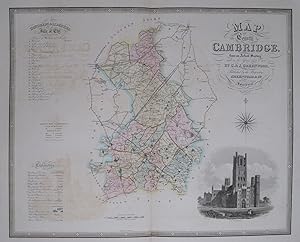
Cambridgeshire. Map of the County of Cambridge, from an Actual Survey made in the Years 1832 & 1833 .
Edité par LondonGreenwood & Co., 1834
Vendeur : Robert Frew Ltd. ABA ILAB, London, Royaume-Uni
Membre d'association : ABA ILAB PBFA
Evaluation du vendeur :
Carte
57 x 71 cm. Original colour in block and outline. Decorative double page engraved map of the county with a vignette view of Ely Cathedral to the lower right corner. Table of explanation and a reference to the hundreds to the right edge. Some light offsetting, otherwise in very good condition.
-
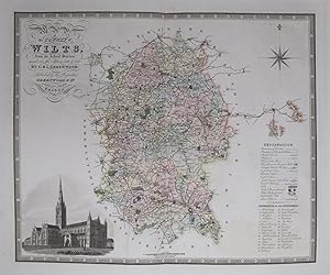
Wiltshire. Map of the County of Wilts, from an Actual Survey made in the Years 1819 & 1820 .
Edité par LondonGreenwood & Co. 1834, 1829
Vendeur : Robert Frew Ltd. ABA ILAB, London, Royaume-Uni
Membre d'association : ABA ILAB PBFA
Evaluation du vendeur :
Carte
55.5 x 67.5 cm. Original colour in block and outline. Decorative double page engraved map of Wiltshire with a vignette view of Salisbury Cathedral to the lower left corner. Table of explanation and a reference to the hundreds to the right edge. Some light offsetting, otherwise in very good condition.
-
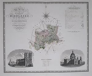
Middlesex. Map Of The County Of Middlesex, From An Actual Survey, Made In The Years 1819 & 1820. .
Edité par LondonGreenwood & Co. 1834, 1829
Vendeur : Robert Frew Ltd. ABA ILAB, London, Royaume-Uni
Membre d'association : ABA ILAB PBFA
Evaluation du vendeur :
Carte
53 x 64 cm. Original colour in block and outline. A decorative double page map of Middleses with large vignette views of Westminster Abbey and St. Paul's Cathedral to the lower corners. Table of explanation to the upper right corner and reference table to the hundreds at the centre of the lower edge. Very good condition.