Montant total (1 article articles) :
Destination de la commande :

H R PAGE & CO (32 résultats)
Passer aux résultats principaux de la recherche
Type d'article
- Tous les types d'articles
- Livres (32)
- Magazines & Périodiques
- Bandes dessinées
- Partitions de musique
- Art, Affiches et Gravures
- Photographies
- Cartes
-
Manuscrits &
Papiers anciens
Etat
Reliure
Particularités
Pays
Evaluation du vendeur
-

H P Lovecraft's The Dunwich Horror / H P Lovecraft, ( Howard Phillips ) and The Happy Man By Gerald R Page / Read - Performed By Atlanta Radio Theatre Company - Audio Cassette ( 90 Minutes )
Edité par Santa Fe, NM: Sunset Productions, 1996, First Edition, 1st Printing, Santa Fe, New Mexico, 1996
ISBN 10 : 1564311279ISBN 13 : 9781564311276
Livre Edition originale
Cassette Tape. Etat : Fine (see description). Jon Coriz Cover Art (illustrateur). First Edition. -----------audio cassette, a Fine example, a scarce HPL item, 90 minutes, contains the HPL and the Page story, ---interior case has space for TWO cassettes BUT the text on the exterior states "1 cassette" so the Page story is an add-on at the end of the Dunwich Horror, any image directly beside this listing is the actual item and not a generic photo, ///NOT SIGNED ---GUARANTEED to be AVAILABLE /// ---sizes are approximate (generally within 1/8 inch)--- Size: 4.5w x 6.75h Inches. Not Signed.
-
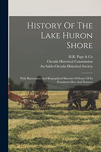
History Of The Lake Huron Shore
Edité par LEGARE STREET PR, 2022
ISBN 10 : 1015668445ISBN 13 : 9781015668447
Livre impression ŕ la demande
PAP. Etat : New. New Book. Shipped from UK. THIS BOOK IS PRINTED ON DEMAND. Established seller since 2000.
Plus de choix d'achat de la part d'autres vendeurs sur AbeBooks
Offres neuf ŕ partir de EUR 31,01
-
![Image du vendeur pour Illustrated guide to Chicago. (1880) [LeatherBound] mis en vente par S N Books World](https://pictures.abebooks.com/inventory/md/md30962790741.jpg)
Illustrated guide to Chicago. (1880) [LeatherBound]
Date d'édition : 2022
Livre impression ŕ la demande
LeatherBound. Etat : New. Leatherbound edition. Condition: New. Leather Binding on Spine and Corners with Golden leaf printing on spine. Bound in genuine leather with Satin ribbon page markers and Spine with raised gilt bands. A perfect gift for your loved ones. Reprinted from 1880 edition. NO changes have been made to the original text. This is NOT a retyped or an ocr'd reprint. Illustrations, Index, if any, are included in black and white. Each page is checked manually before printing. As this print on demand book is reprinted from a very old book, there could be some missing or flawed pages, but we always try to make the book as complete as possible. Fold-outs, if any, are not part of the book. If the original book was published in multiple volumes then this reprint is of only one volume, not the whole set. IF YOU WISH TO ORDER PARTICULAR VOLUME OR ALL THE VOLUMES YOU CAN CONTACT US. Resized as per current standards. Sewing binding for longer life, where the book block is actually sewn (smythe sewn/section sewn) with thread before binding which results in a more durable type of binding. Pages: 102 Language: English Pages: 102.
-
![Image du vendeur pour Providence (1891) [LeatherBound] mis en vente par True World of Books](https://pictures.abebooks.com/inventory/md/md31618264618.jpg)
LeatherBound. Etat : New. LeatherBound edition. Condition: New. Reprinted from 1891 edition. Leather Binding on Spine and Corners with Golden leaf printing on spine. Bound in genuine leather with Satin ribbon page markers and Spine with raised gilt bands. A perfect gift for your loved ones. NO changes have been made to the original text. This is NOT a retyped or an ocr'd reprint. Illustrations, Index, if any, are included in black and white. Each page is checked manually before printing. As this print on demand book is reprinted from a very old book, there could be some missing or flawed pages, but we always try to make the book as complete as possible. Fold-outs, if any, are not part of the book. If the original book was published in multiple volumes then this reprint is of only one volume, not the whole set. Sewing binding for longer life, where the book block is actually sewn (smythe sewn/section sewn) with thread before binding which results in a more durable type of binding. Pages: 206.
-

History Of The Lake Huron Shore: With Illustrations And Biographical Sketches Of Some Of Its Prominent Men And Pioneers
Edité par Legare Street Press, 2022
ISBN 10 : 1015663346ISBN 13 : 9781015663343
Livre
Etat : New.
Plus de choix d'achat de la part d'autres vendeurs sur AbeBooks
Offres neuf ŕ partir de EUR 35,09
Offres d'occasion ŕ partir de EUR 36,49
Trouvez également Couverture rigide
-
![Image du vendeur pour History of the Lake Huron shore. With illustrations and biographical sketches of some of its prominent men and pioneers [LeatherBound] mis en vente par True World of Books](https://pictures.abebooks.com/inventory/md/md31532894191.jpg)
History of the Lake Huron shore. With illustrations and biographical sketches of some of its prominent men and pioneers [LeatherBound]
Date d'édition : 2023
Livre impression ŕ la demande
LeatherBound. Etat : New. LeatherBound edition. Condition: New. Reprinted from 1883 edition. Leather Binding on Spine and Corners with Golden leaf printing on spine. Bound in genuine leather with Satin ribbon page markers and Spine with raised gilt bands. A perfect gift for your loved ones. NO changes have been made to the original text. This is NOT a retyped or an ocr'd reprint. Illustrations, Index, if any, are included in black and white. Each page is checked manually before printing. As this print on demand book is reprinted from a very old book, there could be some missing or flawed pages, but we always try to make the book as complete as possible. Fold-outs, if any, are not part of the book. If the original book was published in multiple volumes then this reprint is of only one volume, not the whole set. Sewing binding for longer life, where the book block is actually sewn (smythe sewn/section sewn) with thread before binding which results in a more durable type of binding. Pages: 364 Language: English.
-
![Image du vendeur pour Captain Ravenshaw, or, The maid of Cheapside a romance of Elizabethan London [LeatherBound] mis en vente par True World of Books](https://pictures.abebooks.com/inventory/md/md31534501294.jpg)
Captain Ravenshaw, or, The maid of Cheapside a romance of Elizabethan London [LeatherBound]
Date d'édition : 2023
Livre impression ŕ la demande
LeatherBound. Etat : New. LeatherBound edition. Condition: New. Reprinted from 1901 edition. Leather Binding on Spine and Corners with Golden leaf printing on spine. Bound in genuine leather with Satin ribbon page markers and Spine with raised gilt bands. A perfect gift for your loved ones. NO changes have been made to the original text. This is NOT a retyped or an ocr'd reprint. Illustrations, Index, if any, are included in black and white. Each page is checked manually before printing. As this print on demand book is reprinted from a very old book, there could be some missing or flawed pages, but we always try to make the book as complete as possible. Fold-outs, if any, are not part of the book. If the original book was published in multiple volumes then this reprint is of only one volume, not the whole set. Sewing binding for longer life, where the book block is actually sewn (smythe sewn/section sewn) with thread before binding which results in a more durable type of binding. Pages: 416 Language: English.
-
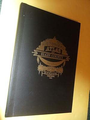
Illustrated Historical Atlas of the County of Elgin, ONT./ Toronto 1877 ( Ross Cumming Atlas Reprints Facsimile ) ( Ontario )((inc. St Thomas, Aylmer, Bismarck, Port Burwell / Bruce / Stanley, Wallacetown, etc)
Edité par Stratford, ON: Ross Cumming Atlas Reprints Facsimile of the H R Page 1877 Edition, 1st edition, 1972 = Ross Cumming edition, 1st OFFSET Edition, First Printing, Stratford, Ontario, 1977
Edition originale
Hard Cover. Etat : Near Fine (see desciption). Text Cover (illustrateur). First Printing. -----------( 1st printing of the Offset edition ) hard cover, a Near Fine example, a bit of light rubbing, small mark on the verso of the front cover, , 58 pages, b&w maps and illustrations, any image directly beside this listing is the actual book and not a generic photo. ///NOT SIGNED --- GUARANTEED to be AVAILABLE /// ---sizes are approximate (generally within 1/8 inch)--- Size: 12.5w x 18h Inches. Not Signed.
-

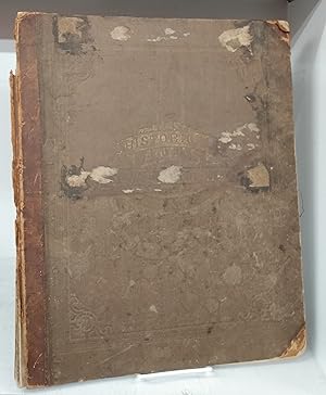
ILLUSTRATED HISTORICAL ATLAS O THE COUNTY OF ELGIN ONT. Dedicated By Special Permission to His Excellency The Earl of Dufferin K. P. K. C. B. Governor General
Edité par Richardson, Bond & Wright Ltd., Owen Sound, 1972
Hardcover. Etat : Very Good. 57 pages in very good condition with maps and illustrations throughout. Reprint of the 1877 edition. Some markings on the table of contents. Blue endpapers, lightly faded around the edges. Quarterbound in black cloth. Gilt titles. Lightly worn and bumped around the edges. Boards are scuffed. VG Size: Folio: 12 x 19 1/2.
-
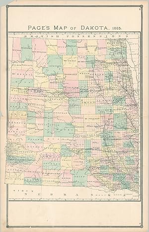
Page's Map of Dakota, 1885 Page's map of the Dakota Territory, published four years before statehood.
Date d'édition : 1885
Vendeur : Curtis Wright Maps, Berwyn, IL, Etats-Unis
Membre d'association : ESA MWABA
Evaluation du vendeur :

Etat : Fine. The appetite for white settlement in the Dakota Territory was relatively muted until the early 1870s, as the local Sioux Indians fiercely defended their ancestral homeland against the relentless encroachment of invaders from the east. But the discovery of gold in the Black Hills by George Armstrong Custer in 1874 changed the equation, and soon the territory was flooded with settlers, fur traders, prospectors, and ranchers closely following the rapidly expanding rail network. Further conflict would erupt with the Great Sioux War in 1876, which saw the death of Custer and Crazy Horse, and ultimately led to the forced relocation of numerous local tribes onto reservations. Several such Native American sequestrations can be seen on this map, concentrated in the northern and southwestern areas of the territory. Topography is depicted in hachure and numerous geographic features like buttes and mountain peaks are labeled. Elsewhere, one can see a fascinating variety of place names that reflects frontier settlements, fortifications, Native American villages, trading posts, and more. Railroad routes are boldly outlined, notably the critically important Northern Pacific Railroad - the fifth American transcontinental line, completed in 1883. The map was published two years later, in 1885, by H.R. Page & Co. in Chicago. Sheet Width (in) 17.25 Sheet Height (in) 27.25 Condition Description Scattered soiling visible in the large blank spaces at the top and bottom of the sheet, as well as in the margins. The upper left corner is chipped and there are a few other small tears around the outer edges of the sheet, away from the image. Very good condition overall.
-
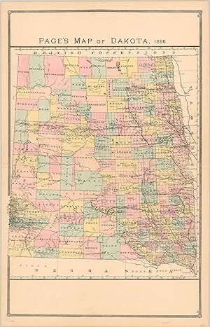
Page's Map of Dakota 1886 Page's map of the Dakota Territory, published three years before statehood.
Date d'édition : 1886
Vendeur : Curtis Wright Maps, Berwyn, IL, Etats-Unis
Membre d'association : ESA MWABA
Evaluation du vendeur :
Etat : Fine. The appetite for white settlement in the Dakota Territory was relatively muted until the early 1870's, as the local Sioux Indians fiercely defended their ancestral homeland against the relentless encroachment of invaders from the east. But the discovery of gold in the Black Hills by George Armstrong Custer in 1874 changed the equation, and soon the territory was flooded with settlers, fur traders, prospectors, and ranchers closely following the rapidly expanding rail network. Further conflict would erupt with the Great Sioux War in 1876, which saw the death of Custer and Crazy Horse, and ultimately led to the forced relocation of numerous local tribes onto reservations. Several such areas can be seen on this map, concentrated in the north and southwestern areas of the territory. Elsewhere, one can see scattered homesteads, prominent geographic features, and the critically important Northern Pacific Railroad - the fifth American transcontinental line, completed in 1883. The map was published three years later, in 1886, by H.R. Page in Chicago. Sheet Width (in) 17.9 Sheet Height (in) 27.8 Condition Description Near fine condition, with a few small edge tears and faint wear along the horizontal centerfold.
-
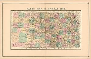
Page's Map of Kansas 1886 Attractive hand colored map of Kansas from the late 19th century.
Date d'édition : 1886
Vendeur : Curtis Wright Maps, Berwyn, IL, Etats-Unis
Membre d'association : ESA MWABA
Evaluation du vendeur :
Etat : Fine. "People from all across the country, and even the world, flocked to Kansas in the years and decades following the Civil War. According to the state historical society, "after the Civil War and before 1890 the population of Kansas increased by the greatest amount in its history." The Homestead Act provided for cheap, arable land available to anyone who could get there; including freed slaves and European immigrants by the thousands. This map, published by H.R. Page & Co. in 1886, shows the result of such impressive population growth. Notably, the corresponding growth of the railroad is evident, with lines connecting much of the state; especially in the east. This ready access greatly benefited local farmers and was also a draw for cowboys from Texas, who would drive huge herds of cattle for shipping to markets back east. Apart from the railroads, transportation systems were rudimentary at best, and the scattered isolated towns would have been reachable only by water, horse, or foot. Source." Sheet Width (in) 27.1 Sheet Height (in) 17.3 Condition Description Faint offsetting visible along the top and bottom of the sheet and light discoloration and wear along vertical centerfold.
-
ILLUSTRATED HISTORICAL ATLAS OF THE COUNTIES OF HALDIMAND AND NORFOLK
Edité par The University of Western Ontario
Hardcover. Etat : Very Good. 111 pages in very good condition. n.d. (1970s). Reprint of original 1879 edition. Pages are clean and unmarked with black and white maps and illustrations throughout. Blue endpapers. Previous owner's signature on the ffep. Quarterbound in black cloth with gilt titles on the upper cover. Boards are scuffed, and lightly soiled and stained around the edges. Worn on the corners with some torn cloth near the upper-fore corner on the head edge. SCARCE. VG Size: Folio: 12 x 17.
-
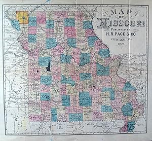
Map of Missouri
Edité par Chicago, Chicago, 1881
Vendeur : High Ridge Books, Inc. - ABAA, South Deerfield, MA, Etats-Unis
Membre d'association : ABAA ESA ILAB SNEAB
Evaluation du vendeur :

Folding map issued without covers by the Bank of Creston, Iowa. Splits along several folds, 2.5x1.5 cm. hole at a fold junction in Henry and Johnson Counties. Smaller hold in Bates County. Full color by county. Manuscript at top of printed title on the verso, "Dist. No. 1, Twp. 64, R. 35, Marysville, Missouri." There is also a manuscript note on the face of the map pointing to District 1 in Nodaway County in the northwestern corner of the state.
-
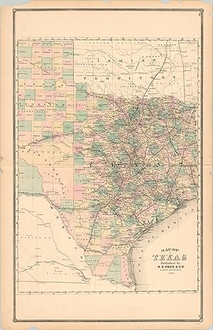
Map of Texas A misprinted map of the settled portion of Texas from the late 19th century.
Date d'édition : 1886
Vendeur : Curtis Wright Maps, Berwyn, IL, Etats-Unis
Membre d'association : ESA MWABA
Evaluation du vendeur :
Etat : Fine. This detailed map of the state of Texas was published in Chicago by H.R. Page & Co. in 1886. Although it omits several thousand square miles from the western end of the state, this may be forgiven due to the cartographer's efforts to focus on the more populated areas. The rapidly expanding network of railroads can be is shown in dark black lines, linking the various ranches, farms, and mines to the ready markets back east. West bound lines are limited to the newly incorporated Galveston, Harrisburg and San Antonio Railway and the Texas and Pacific Railway. Sparsely populated counties in the northern panhandle reflect ongoing land reforms which took place throughout the late 19th century. Though not the subject of the image, the adjacent Indian Territory also contains noteworthy information. The Indian Appropriations Act of 1885 allowed Congress to negotiate and buy unoccupied lands from tribes within the territory. Several such cessions are noted- these and others would ultimately fuel the several land rushes that took place in the 1880's and 1890's, ultimately leading to the state of Oklahoma. Sheet Width (in) 17.9 Sheet Height (in) 27.6 Condition Description Several small chips and tears along the outer margins and faint wear along the horizontal centerfold. Very good condition overall, with original hand color and a dark impression.
-
Illustrated Historical Atlas of the County of Middlesex Ont
Edité par H.R. Page & Co., Toronto, 1878
Vendeur : Attic Books (ABAC, ILAB), London, ON, Canada
Membre d'association : ABAC ILAB
Evaluation du vendeur :
Hardcover. Etat : Good. 68, [3] p. 45 cm. Maps include 11 two-page and 9 one-page. Portraits of prominent citizens, and views of local estates. Rebacked hardcover binding with gold and blind impressing on cloth boards. Wear, staining, and discolouration to boards. Foxing to endpapers and an ink inscription on the front endpaper (Given to Alexander Robert Ross, Georgina McLellan, Geo. McLellan). Stains and thumbing throughout, mainly to margins. Historical Sketch of the County of Middlesex in Ontario, Canada. Includes Historical introduction, personals, patron's directory, maps, townships, towns and villages, portraits, views. Provides a reference guide in the table of contents and a business directory from 1878 at the back. While there have been many reprints of this atlas, this is an original and a "must have" item for collectors of Southwestern Ontario history.
-
Illustrated Historical Atlas of the County of Elgin Ont.
Edité par H. R. Page & Co, Toronto, 1877
Vendeur : Attic Books (ABAC, ILAB), London, ON, Canada
Membre d'association : ABAC ILAB
Evaluation du vendeur :
Hardcover. Etat : Good. [4], xxviii, 60, [10] p. 44 cm. 29 pages of partial-colour maps, 27 pages of portraits and scenery. 2 p. of ads at front and 10 p. of advertising at rear. Rebound in black cloth spine with brown paper boards. Some soiling to exterior, especially rear of spine. Some wear to edges and some light scratches on rear. Newer endpapers. Binder's label on rear pastedown dates to 1963. Numerous unprofessional but neat clear tape repairs. Some rebuilt margins and corners, mainly first and last advertising pages. Some thumbing and light soiling. The atlas consists of historical text, biographies of well-known men, township and town maps, portraits, views, and a patrons' or business card directory. Names of residents are marked on the lots of the township maps. Prominent county residents paid an additional sum to have biographical sketches, portraits, and views of their residences or businesses included. Note the Table of Contents provides a reference list in both English and German, reflecting the Mennonite community near Aylmer.
-
Illustrated Historical Atlas of the County of Norfolk Ont.
Edité par Toronto, 1877
Vendeur : Attic Books (ABAC, ILAB), London, ON, Canada
Membre d'association : ABAC ILAB
Evaluation du vendeur :
Hardcover. Etat : Fair. 20, 57, 3 p. 45 cm. 7 township maps, 22 maps of towns and villages, 11 other maps of Ontario, Quebec, etc. 29 views of residences and other buildings. 24 portraits. Coat of arms on title. Maps in partial-colour. Original quarter leather with cloth. Boards detached, spine deteriorated, corners and edges worn, paper stuck to front board. Front endpaper has architectural drawing in pencil. Chips and creases in front free endpaper. Last text page is detached, along with one rear advertising page. Worm holes to page edges ip. 17 onwards, not affecting text or pictures. Some thumbing and soiling to pages. Maps of Ontario, Quebec, the U.S.A., Manitoba, Ottoman Empire, County of Norfolk, Long Point, County of Brant, Eastern and Western Hemispheres, and Elgin County. Maps of the townships: Woodhouse, Townsend, Windham, Charlotteville, Walsingham, Middleton and Houghton. Town and village maps include Simcoe, Port Dover, Port Ryerse, Normandale, Port Rowan and many smaller places. Numerous post offices marked. Also farmhouses, schools, churches, roads, railroads, and much more. Property owners marked on township maps.
-
Illustrated Historical Atlas Of The County Of Middlesex Ont Compiled Drawn and Published from Personal Examinations and Surveys.
Edité par Toronto: 1878., 1878
Vendeur : D & E LAKE LTD. (ABAC/ILAB), Toronto, ON, Canada
Membre d'association : ABAC ILAB
Evaluation du vendeur :

Edition originale
Hardcover. 1st Edition. folio. pp. 20, [9], 68, [3]. lithographed title. pp. 1-68 containing numerous lithographed illus. (views & portraits) & coloured maps (many double-page). rebound in new half leather-grained cloth, the original blind & gilt-stamped cloth sides mounted (covers faded & spotted, some soiling & foxing, some marginal defects, numerous cello-tape repairs mainly in margins but the first 3 maps more extensively repaired, some loss near centre at lower edge of map of Canada on pp. 2-3). First Edition. Morley p. 72. May pp. 92-97.
-
Illustrated Historical Atlas of the County of Elgin Ont.
Edité par H. R. Page & Co, Toronto, 1877
Vendeur : Attic Books (ABAC, ILAB), London, ON, Canada
Membre d'association : ABAC ILAB
Evaluation du vendeur :
Hardcover. Etat : Fair. xxviii, 60, [12] p. 44 cm. 30 pages of colour or half-tone maps, including fold-out of Southwold Township. 27 pages of portraits and scenery. 12 p. of advertising at rear. Rebound in leather with original cloth boards, gilt and blank impressing. Some wear and spotting to cloth. Hinges repaired internally. Ink inscription crossed out on front pastedown. Chipped corners to title page, a few small tears and spots, large tear in p. XXIII, chipped edges and repaired tear in fold-out map, rear free endpaper loosening at top, chip in edge of rear pastedown. Illustrated atlases are rarely complete, neat, or clean, but this Elgin Atlas, printed by H. R. Page & Co. of Toronto, has all its parts and looks fresher and tidier than most. The atlas consists of historical text, biographies of well-known men, township and town maps, portraits, views, and a patrons' or business card directory. Names of residents are marked on the lots of the township maps. Prominent county residents paid an additional sum to have biographical sketches, portraits, and views of their residences or businesses included. Note the Table of Contents provides a reference list in both English and German, reflecting the Mennonite community near Aylmer. The signature of W. R. Jackson on the front pastedown may be that of a well-known hardware store owner or jeweller in St. Thomas, but there is also a William Jackson, furniture seller, in the rear advertising section. A charming piece of southwestern Ontario history.
-
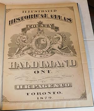
ILLUSTRATED HISTORICAL ATLAS OF THE COUNTY OF HALDIMAND ONT. Compiled Drawn and Published from Personal Examinations and Surveys by H.R. Page & Co.
Edité par Toronto, Ontario: H.R. Page & Co., 1879., 1879
Vendeur : Blue Mountain Books & Manuscripts, Ltd., Cadyville, NY, Etats-Unis
Evaluation du vendeur :
Edition originale
Etat : Fair. Toronto, Ontario: H.R. Page & Co., 1879., 1879. Fair. - Folio, 17-3/4 inches high by 14-5/8 inches wide, Hardcover, rebound in dark green cloth with the original titling laid down. The covers are rubbed and stained. Pages [1]-24, [52-53], [1 leaf], [56-57], 1-49 & [1-5], as per the table of contents. The contents consist of the original title page which has been laid down on a larger sheet, a table of contents, the "Historical Sketch of the County of Haldimand" [pages 5 through 19], a "Business Directory of Haldimand County" [pages 20 through 24], a double-page color map of "Quebec and Lower Provinces" [paginated as 52-53 in the table of contents], a double-page color map of the "United States" [paginated as 56-57 in the table of contents], followed by profuse engraved maps & plates, with illustrations of local business cards on the last 4 pages. There is some foxing & soiling throughout with a few tiny marginal tears. A larger tear to the table of contents has been repaired with archival linen tape on the verso. The full-page plate of the "American Hotel, Jarvis" [page 15] has been repaired with linen tape along the lower inch of the image. The "Map of Ontario" on page 23 has been repaired with linen tape affecting some of the lower part of the image with corresponding repairs to the "Map of the Township of North Cayuga" on the verso [page 24]. There are several other small repairs to the edges of a few pages which does not affect the images. A complete RARE Canadian Atlas. RARE FIRST EDITION.
-
Illustrated Historical Atlas of the County of Norfolk Ont.
Edité par H.R Page & Co, Toronto, 1877
Vendeur : Alexandre Antique Prints, Maps & Books, Toronto, ON, Canada
Membre d'association : ABAC ILAB
Evaluation du vendeur :
Recent half morocco saving the original gilt cloth boards. Upper board with Blind tooled rules with decorative corners as well as tooled gilt lettering and design., Size : Folio (455mmx380mm), Illustrated with maps of which include the following : Maps: Dominion of Canada (Western Sheet), Dominion of Canada (Eastern Sheet), Railroad Map of the United States, Province of Manitoba., Map of the Ottomon Empire, County of Norfolk,Map of Woodhouse, Township of Windham, Township of Charlottevilled, Port Dover, Port Ryerse, Normandale, Map of the township of Waslingham, Village of Langton, Windham Centre, Lydoch, Nixon, Teeterville, Fredricksburg, Kelvin, Croton, Middleton, Houghton, Courtland, St. Williams, Simcoe, Village of Waterford, Brownstown or Walsinghm Centre, Renton, Rockford, Vittoria, Port Rowan, Walsh, Portland, Map of the County of Brant, Eastern Hemisphere, Map of the County of Elgin, Western Hemisphere. A few maps remargined otherwise in very good condition.
-
Illustrated Historical Atlas of the County of Elgin Ont. Dedicated by Special Permission to His Excellency The Earl of Dufferin K.P.K.C.B. Governor General Comiled Drawn and Published from Personal Examinations and Surveys by H.R. Page & Co.
Edité par H.R. Page & Co., Toronto, 1877
Vendeur : Alexandre Antique Prints, Maps & Books, Toronto, ON, Canada
Membre d'association : ABAC ILAB
Evaluation du vendeur :
Original cloth boards with tooled gilt lettering and design. , Size : Folio (440mm x 350mm), Illustrated with maps of which include the following:Dominion of Canada (Western sheet), Dominion of Canada (Eastern Sheet), Railroad of the United States, Map of the Province of Manitoba and part of the District of Keewatin and North West Territory Shewing The Townships & Settlements Drawn from the Latest Gov. Maps, Surveys & Reports for The Prairie Province; Map of the County of Elgin Ontario, Aylmer, Richmond, Springfield, Township of Aldborough, Pt. Stanley, Delaware, Southwold, Westminster, Dunwich, Yarmouth, Tyrconnell, Corinth, South Dorchester, Bayham, Vienna, Dunwich, Straffordville, Wallacetown, Yarmouth, Sparta, Iona, Union, Bismark and Lorne, Dutton, Orwell, New Glascow, Shedden, Pr. Burwell, Pt. Bruce, Rodney, Town of St. Thomas, Boards worn, spine defective, title page is loose. Otherwise in good condition.