Montant total (1 article articles) :
Destination de la commande :

HENDSCHEL, U (13 résultats)
Passer aux résultats principaux de la recherche
Type d'article
- Tous les types d'articles
- Livres (11)
- Magazines & Périodiques
- Bandes dessinées
- Partitions de musique
- Art, Affiches et Gravures
- Photographies
- Cartes (2)
-
Manuscrits &
Papiers anciens
Etat
Reliure
Particularités
- Edition originale
- Signé
- Jaquette (1)
- Avec images (4)
- Sans impression ŕ la demande (11)
Pays
Evaluation du vendeur
-
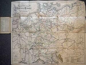
Neueste Eisenbahn-Karte von Central-Europa mit genauer Angabe aller Stationen und der influirenden Post-Verbindungen
Edité par Frankfurt a. M. : Carl Jügel's Verlag (Nachdruck Plasser & Theurer)
Vendeur : Antikvariat Valentinska, Praha, Rébublique tchčque
Membre d'association : ILAB
Evaluation du vendeur :

Nachdruck einer lithogr. Karte, 8 x 4 Felder zu 11 x 18 cm, insgesamt 87 x 74 cm, sauber, insgesamt sehr guter Zustand. Book Language/s: German.
-

Hendschel's Telegraph. Uebersicht d. Eisenbahn-, Post-, Dampfschiff- u. Telegraphen-Verbindungen Deutschlands u. d. angrenzenden Länder. Nach den Noitzen des Coursbureau's der Fürstl. Thurn u. Taxis'schen General-Post-Direktion.
Edité par Landsberg-Pürgen, Ritzau KG Zeit u. Eisenbahn, 1976., 1976
ISBN 10 : 3921304245ISBN 13 : 9783921304242
Vendeur : Bojara & Bojara-Kellinghaus OHG, Osnabrück, Allemagne
Evaluation du vendeur :
Livre
Nachdruck der Ausgabe Frankfurt/M., Hendschel, 1856. Jg. 10, Nr. 2. 19 cm. XII, 153 S. OKt. - Ohne die Karte, die seinerzeit separat erschien. - Rücken verblasst, gutes Ex. 1.
-
Neue Verlags-Artikel von Carl Jugel in Frankfurt a/M.
Edité par Legare Street Press, 2022
ISBN 10 : 1015683061ISBN 13 : 9781015683068
Livre impression ŕ la demande
Paperback / softback. Etat : New. This item is printed on demand. New copy - Usually dispatched within 5-9 working days.
-
Morphologie u. Anatomie d. Enteropneusten Saccoglossus pygmaeus Hinr.& Jac. - Die Verbreitung d. pelag. Fischbrut in d. südl. Nordsee während d. Frühjahrsfahrten 1926-1937. d. dt. Forschungsschiffe "Poseidon" u. "Makrele". - Die Befruchtung u. Entwicklung v. Plattfischeiern in verdünntem Nordseewasser im Vergleich zu d. Befunden in d. freien Ostsee. - Neue Untersuchungen üb. d. Atemmechanismus mariner Teleosteer.
Edité par Helgoland, 1941
Vendeur : Zentralantiquariat Leipzig GmbH, Leipzig, Allemagne
Membre d'association : BOEV
Evaluation du vendeur :

4°. M. zahlr. Abb. 116 S. (Helgol. wiss. Meeresuntersuch. 2/2). Sprache: Deutsch 0 gr.
-
Neue Verlags-Artikel von Carl Jugel in Frankfurt a/M.
Edité par Legare Street Press, 2022
ISBN 10 : 1015677940ISBN 13 : 9781015677944
Livre impression ŕ la demande
Hardback. Etat : New. This item is printed on demand. New copy - Usually dispatched within 5-9 working days.
-

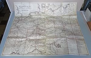
Neueste Eisenbahn-Karte von Central-Europa mit genauer Angabe der Stationen und, den influirenden Post-Verbindungen. Nach den neuesten u. zuverlässigsten Quellen bearbeitet von U. Hendschel,
Edité par Frankfurt a.M. Carl Jügel ' s Verlag 1877,, 1877
Vendeur : Johann Peter Hebel Antiquariat, Lörrach, Allemagne
Evaluation du vendeur :
Grösse : H 76 x B 86 cm. illustr.Orig.Kart. geb.8° (Rü. nachgebunden) 1 Bl. S. grosse gefaltete farbige Karte auf 32 Segmenten ( kolor. Lithographie ) (Karte z.Tl. geklebt am Rand sonst guter Zustand).
-
Neueste Eisenbahn-Karte von Central-Europa, mit genauer Augabe alter Stationen und der influirenden Post-Verbindungen
Edité par Frankfurt c.1860, Frankfurt, 1860
Vendeur : High Ridge Books, Inc. - ABAA, South Deerfield, MA, Etats-Unis
Membre d'association : ABAA ESA ILAB SNEAB
Evaluation du vendeur :
Large folding map, unbacked with original printed boards. Very good condition, with wear at edges, short splits along two folds. Shows from eastern England to the northern Balkans and Belgrade, though with greatest detail in Germany. Rail lines are the primary features shown, with national or regional boundaries colored. Key identifies the many political subdivisions, including many German states.
-
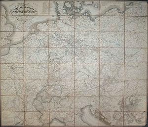
Hendschels s Post und Reise-Karte von Deutschland. Gezeichnet und gestochen von Jos. Back und C. Sauter. Karte bis London, Paris, Montpellier, Florenz, Warschau, Kopenhagen.
Edité par U. Hendschel (1842),, Frankfurt,, 1842
Carte
8°, 128 x 106 cm in 8 x 6 Segmenten, Zustand 1, mm-großes Fleckchen nahe Metz, einige braune Fleckchen auf Legende. Sprache auf Karte Deutsch, 5 auf Leinen aufkaschierte Legenden in Französisch. Karte auf Leinen aufgezogen in späterem Leinenschuber mit Steckklappe.
-
Topographisches Rhein-Panorama von Schaffhausen bis zur Nordsee. In grossem Maasstabe entworfen und mit den speziellen Karten des grössten Theiles von Holland & Belgien sowie den Umgegenden des Bodensee's, der Mosel, der Ahr, Nahe und 27 genauen Städteplänen. Gezeichnet von U. Hendschel, Verfasser der grossen Postkarte von Deutschland, gestochen von W. Haase. Nebst einer historischen Einleitung von Eduard Duller und erläuternden Notizen für Reisende über die interessantesten Städte obiger Gegenden.
Edité par Verlegt von Karl Jügel, Frankfurt am Main, 1845
Vendeur : Antiquariat am St. Vith, Mönchengladbach, Allemagne
Evaluation du vendeur :
Livre
Leinen. Gr.-Oktav. 97 S. u. Karten. Leinen mit Deckelgoldprägung. Zustand! Bibliotheksexemplar (mit Rückensignaturen und gestempelt), Hinterdeckel mit Wasserschaden, Papier meist stärker braunfleckig, 1 gefalt. Rhein-Panorama in einem Falz durchtrennt. Mit 1 Frontispiz, mehrfarb. Titelblatt und zahlr. Karten u. Stadplänen.
-
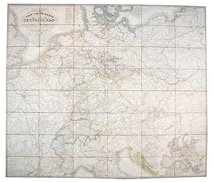
Post- und Reise-Karte von Deutschland und den Nachbarstaaten bis London, Paris, Montpellier, Nizza, Florenz, Pesth, Warschau und Kopenhagen nach den neuesten und zuverl?ssigsten Quellen bearbeitet.
Edité par Frankfurt, Frankfurt, 1851
Vendeur : High Ridge Books, Inc. - ABAA, South Deerfield, MA, Etats-Unis
Membre d'association : ABAA ESA ILAB SNEAB
Evaluation du vendeur :
Large folding postal map, dissected and backed with linen. Very good condition, with wear at extremities, one small piece of the bottom right corner chipped off. Shows roughly from London to the Adriatic Sea, though with greatest detail in Germany where the postal routes are color coded.
-
Topographisches Rhein-Panorama von Schaffhausen bis zur Nord-See. Erste Abtheilung von Mainz bis Holland und Belgien mit den Umgegenden der Mosel, der Nahe, der Ahr &c. u. den Plänen von Amsterdam, dem Haag, Rotterdam, Utrecht, Antwerpen, Brüssel, Aachen, Düsseldorf, Cöln, Elberfeld, Barmen, Bonn, Neuwied, Coblenz, Mainz, Wiesbaden, Darmstadt & Frankfurt a.M. Gestochen von W. Haase.
Edité par Frankfurt a.M.: Jügel, 1852., 1852
Etat : 0. Grenzkolorierte grosse Faltkarte u. Stahlstichpläne. De Orig.-Halbleinwand, leicht berieben u. teilw. etwas stockfl.
-
Carl Jugel's Post- u. Reise-Karte von Deutschland und den Nachbar-Staaten, bis London, Paris, Montpellier, Florenz, Warschau, Kopenhagen. Bearbeitet von U. Hendschel. und unter dessen Leitung gezeichnet u. gestochen von Jos. Back & Sauter.
Edité par Back u. Sauter Frankfurt a/M ?, 1850
Vendeur : Shapero Rare Books, London, Royaume-Uni
Membre d'association : ABA ILAB PBFA
Evaluation du vendeur :
Carte
Engraved map, hand-coloured in outline, dissected and mounted on linen, extending west to east from London to Warsaw and north to south from Copenhagen to Florence, cartouche upper left, inset road map of Europe lower right, table of European postal rates, and distances and times between cities pasted to verso, publisher's label and key to map pasted to endpapers. BLMC Maps 26945.(27.).
-
Carl Jügel`s Post- u. Reise-Karte von Deutschland und den Nachbarstaaten bis London, Paris, Montpellier, Nizza, Florenz, Pesth, Warschau und Kopenhagen . Bearbeitet von U. Hendschel . und unter dessen Leitung gezeichnet u. gestochen von Jos. Back & Sauter. Mit einem Anhange über die Extrapost-Taxen, Postillions-Trinkgelder und Wagenmeister-Gebühren aller auf dieser Karte erscheinenden Staaten, so wie einem Routen-Kärtchen von ganz Europa, welches die Total-Entfernungen der bedeutendsten Städte in deutschen Meilen angiebt = Nouvelle carte postale et routičre de l`Allemagne et des pays limitrophes
Edité par Frankfurt a. M., Jugel,, 1842
Vendeur : Antiquariat am Roßacker, Rosenheim, Allemagne
Evaluation du vendeur :
Livre
Kl.-8°, Orig.Pappschuber. Dekorative und großformatige Faltkarte (ca. 110 x 125 cm.) mit herrlicher Reiter-Posthorn-Kartusche. Die Karte umfasst praktisch ganz Europa ohne Russland und Spanien mit sämtlichen Post-und Bahnverbindungen sowie Reiserouten. Gute Erhaltung der frühesten Ausgabe im Orig.Umschlag (teils berieben) Sprache: Deutsch Gewicht in Gramm: 550.