Montant total (1 article articles) :
Destination de la commande :

HENRY POPPLE (15 résultats)
Passer aux résultats principaux de la recherche
Type d'article
- Tous les types d'articles
- Livres (4)
- Magazines & Périodiques
- Bandes dessinées
- Partitions de musique
- Art, Affiches et Gravures
- Photographies
- Cartes (11)
-
Manuscrits &
Papiers anciens
Etat
- Tous
- Neuf
- Ancien ou d'occasion
Reliure
Particularités
- Edition originale (2)
- Signé (2)
- Jaquette (1)
- Avec images (6)
- Sans impression ŕ la demande
Pays
Evaluation du vendeur
-

The Grand Fishing Bank
Edité par Henry Popple c. 1733, London, 1733
Vendeur : Alexandre Antique Prints, Maps & Books, Toronto, ON, Canada
Membre d'association : ABAC ILAB
Evaluation du vendeur :

Carte
This chart depicts depth soundings in the Grand Bank off the coast of Newfoundland., Size : 350x135 (mm), 13.78x5.31 (Inches), Hand Colored Very Good; laid down on acid-free paper for long-term preservation.
-
The Harbour of Placentia.
Edité par c.1741, London, 1741
Vendeur : Alexandre Antique Prints, Maps & Books, Toronto, ON, Canada
Membre d'association : ABAC ILAB
Evaluation du vendeur :
Carte
Size : 85x153 (mm), 3.35x6.02 (Inches), Hand Colored Very Good; backed with acid free paper for long term preservation.
-
Boston Harbour
Edité par Henry Popple c. 1733, London, 1733
Vendeur : Alexandre Antique Prints, Maps & Books, Toronto, ON, Canada
Membre d'association : ABAC ILAB
Evaluation du vendeur :
Carte
Depth soundings are given for the entry to Boston harbour., Size : 142x154 (mm), 5.59x6.06 (Inches), Hand Colored in Outline Very Good; laid down on acid-free paper for long-term preservation.
-
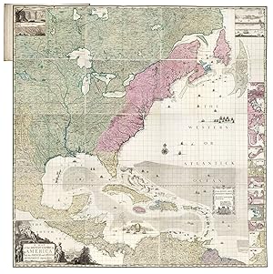
![Image du vendeur pour Carte Particuliere de l'Amerique Septentrionale. [Secondary title:] A Map of the British Empire in America with the French, Spanish and the Dutch Settlements Adjacent thereto by Hen. Popple at Amsterdam mis en vente par James Arsenault & Company, ABAA](https://pictures.abebooks.com/inventory/md/md31759932255.jpg)
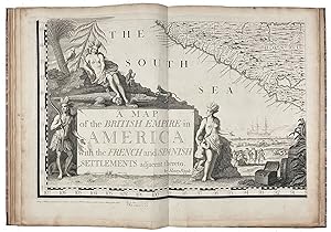
Carte Particuliere de l'Amerique Septentrionale. [Secondary title:] A Map of the British Empire in America with the French, Spanish and the Dutch Settlements Adjacent thereto by Hen. Popple at Amsterdam
Edité par Amsterdam: Printed for J. Covens and C. Mortier, [c. 1740], 1740
Vendeur : James Arsenault & Company, ABAA, Arrowsic, ME, Etats-Unis
Membre d'association : ABAA ESA ILAB
Evaluation du vendeur :

Carte Signé
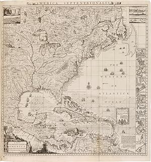
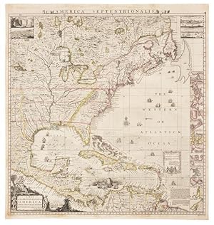
Hand-colored copperplate engraving, 19.875" x 18.75" plus margins. CONDITION: Very good, bit of separation at fold just slightly into image at bottom; a fine, dark impression, with pleasing outline color. This is the Dutch edition (title in French, the rest of the map in English) of the index map for Henry Popple's monumental 20-sheet map of North America, the first large scale British map of the American Colonies, and the first English map to name all thirteen. The map extends from lower Canada to northern South America, and from the eastern seaboard as far west as the Mississippi and its western tributaries. Inset views of Niagara Falls (after Father Louis Hennepin, 1698), Mexico City, Quebec (after J.B.L. Franquelin, 1688) and New York City (after William Burgis, 1720) appear in the upper left and right hand corners respectively. On the right is a series of eighteen inset maps depicting Boston, New York, Charlestown, Bermuda, St. Augustine and other places. A handsome cartouche appears in the lower left corner, picturing several native people, an alligator, and two monkeys; a group of European men is seen standing on the beach in the background and several ships are visible n the distance beyond. "Henry Popple published his map during a time of conflict between the English and French in the north in Canada, and in the west in Louisiana, and between the English and the Spanish in the south in Florida. In effect, therefore, the English colonies of the eastern seaboard found themselves entirely surrounded" (Goss). Henry Popple (d. 1743) was a geographer, mathematician, author and publisher. He served as clerk to the Board of Trade in 1727, and agent for the same to various West Indian governments from 1728 to 1739. His Map of the British Empire in America is the only printed map to his credit. Popple is believed to have had little or no training in mapmaking, and the draughtsmanship is generally credited to his assistant, Clement Lempriere (1683-1746), a military engineer, engraver and cartographer, who served with the British Army and was chief draughtsman at the Tower of London. Signed by the engraver, Johannes Condet (1711-1781), at lower right. REFERENCES: McCorkle, New England in Early Printed Maps, 741.3; Goss, The Mapping of North America, p. 122; Phillips, Maps of America, p. 569; Tooley's Dictionary of Mapmakers.
-
[New England, sheet 7]
Edité par Willm. Henry Toms & R.W. Seale c.1743, London, 1743
Vendeur : Alexandre Antique Prints, Maps & Books, Toronto, ON, Canada
Membre d'association : ABAC ILAB
Evaluation du vendeur :
Carte
A map of the British Empire in America with the French and Spanish settlements adjacent thereto [sheet 7], showing New England., Size : 505x704 (mm), 19.88x27.72 (Inches), Hand Colored Very Good, backed on acid free tissue paper for long term preservation.
-
Nouvelle Carte Particuliere de l'Amerique ou sont exactement marquees la Nouvelle Bretagne, le Canada ou Nouvelle France, la Nouvelle Ecosse, la Nouvelle Angleterre, la Nouvelle York, la Pensilvanie, Mary-Land, la Caroline Septentrionale l'Ile de Terre Neuve, le Grande Banc &c
Edité par Covens & Mortier, Amsterdam, 1741
Vendeur : Alexandre Antique Prints, Maps & Books, Toronto, ON, Canada
Membre d'association : ABAC ILAB
Evaluation du vendeur :
Carte
Etat : Excellent. Detailed East Coast map of the US (of the four sheets) published by Covens & Mortier based on the famous Popple's 20 sheet map of North America. This finely engraved map shows eastern Canada, New England, New York, New Jersy, Maryland and large parts of Pennsylvania, Virginia and North Carolina., Size : 603x530 (mm), 23.75x20.875 (Inches), Original Hand Coloring, 0.
-
Nouvelle Carte Particuliere de l'Amerique/A Map of the British Empire with the French Spanish and the Dutch Settlements adjacent thereto by Henry Popple, a London. Grave par Jean Conr. Back.
Edité par Ottens, Amsterdam, 1745
Vendeur : Arader Galleries of Philadelphia, PA, Philadelphia, PA, Etats-Unis
Evaluation du vendeur :
Livre
N/A. Etat : Very Good. Etat de la jaquette : N/A. Engraving with incredible original hand-coloring. A key/location map to Popple's famous work. Sheet size: 25 x 21 1/8". Inventory#: p1018pmat.
-
Nouvelle Carte Particuliere de l'Amerique ou sont exactement marquees une Partie de la Baye d'Hudson, le Pays des Kilistinons, la Source de la Grande Riviere de Mississipi, le Pays des Illinois &c
Edité par Covens & Mortier, Amsterdam, 1741
Vendeur : Alexandre Antique Prints, Maps & Books, Toronto, ON, Canada
Membre d'association : ABAC ILAB
Evaluation du vendeur :
Carte
Etat : Very Good. Detailed map of the Great Lakes published by Covens & Mortier based on the famous Popple's map of North America., Size : 606x531 (mm), 23.875x20.875 (Inches), Original Hand Coloring, 0.
-
A Map of the British Empire in America with the French, Spanish and the Dutch Settlements./ Nouvelle Carte Particuliere de L'Amerique ou Sont Exactement Marquees les Iles de Bermude, La Iamaique, Saint Domingue, les Antilles, La Terre Ferme, & c.
Edité par c.1741, Amsterdam, 1741
Vendeur : Alexandre Antique Prints, Maps & Books, Toronto, ON, Canada
Membre d'association : ABAC ILAB
Evaluation du vendeur :
Carte
Etat : Very Good. Fine decorative map of the whole West Indies in two sheets by Mortier based on the large map of Americas by Popple: , Size : 600x533 (mm), 23.62x20.98 (Inches), Original Hand Coloring.
-
A Map of the British Empire in America with the French and Spanish Settlements thereto.
Edité par London, ca. 1734, 1734
Vendeur : Arader Galleries - AraderNYC, New York, NY, Etats-Unis
Evaluation du vendeur :
Edition originale Signé
Unbound. Engraved map hand-colored in outline (Image: 19 1/2 x 19 in.; 49.5 x 48.3 cm. Sheet: 21 x 20 in.; 53.3 x 50.8 cm), decorative cartouche depicting Native Americans and European settlers, insets of Niagara Falls, Mexico, Quebec, and New York, small insets of 17 harbors including Boston, New York, Charleston, and Porto Bello. BINDING/CONDITION: Floated on sturdy card stock and enclosed in mylar. One or two tiny tears in left margin, margins lightly toned. (65B1D) FIRST EDITION, BABINSKI'S FIRST STATE of Popple's key map: without imprint below border at lower left, imprint bottom right signed "W. H. Toms. Sculp.," with the course of the Spanish galleons not present, Cape May and Cape Hinlopen not named off Delaware Bay. This copy is like "most, if not all, colored copies [which] do not have the 4 corner views or the title cartouche at bottom left colored" (Babinski). The key map accompanied Popple's first large-scale map of North America printed on twenty sheets. PROVENANCE: Evelyn and Eric P. Newman (their sale, Leslie Hindman, 12 October 2018, lot 102) REFERENCE: Babinski, Henry Popple's 1733 Map of the British Empire in America Key Map.
-
Nouvelle Carte Particuliere de l'Amerique ou sont exactement marquees une Partie de la Baye d'Hudson, le Pays des Kilistinons, la Source de la Grande Riviere de Mississipi,.; Nouvelle Carte Particuliere de l'Amerique ou sont exactement marquees la Nouvelle Bretagne, le Canada ou Nouvelle France, la Nouvelle Ecosse, la Nouvelle Angleterre, la Nouvelle York.; A Map of the British Empire in America with the French, Spanish and the Dutch Settlements./ Nouvelle Carte Particuliere de L'Amerique ou Sont Exactement Marquees les Iles de Bermude, La Iamaique, Saint Domingue, les Antilles, La Terre Ferme,
Edité par Covens & Mortier c.1741, Amsterdam, 1741
Vendeur : Alexandre Antique Prints, Maps & Books, Toronto, ON, Canada
Membre d'association : ABAC ILAB
Evaluation du vendeur :
Carte
Etat : Very Good. Detailed wall map of the North America published by Covens & Mortier in 4 sheets based on the famous Popple's map of North America., Size : , Original Hand Coloring, 0.
-
A Map of the British Empire in America, with the French and Spanish Settlements Adjacent Thereto
Edité par Sold by the Proprietors S[amuel] Harding on the Pavement in St. Martins Lane, and W[illiam] H[enry] Toms, Engraver in Union Court near Hatton Garden Holborn, London, 1734
Vendeur : Donald A. Heald Rare Books (ABAA), New York, NY, Etats-Unis
Membre d'association : ABAA ILAB
Evaluation du vendeur :
Carte
Folio. (21 x 15 inches). Engraved folding key map in Babinski State 4, showing the track line of Spanish Galleons. Large engraved wall map on 15 double-page and 5 full-page map sheets, numbered in plate and in contemporary ink manuscript, in Babinski State 7, with Harding and Toms's imprint on map sheet 17, on laid paper with Strasbourg Lily watermarks. Ink manuscript sheet key opposite key map, which also carries ink manuscript configuration guidance. Finely bound to style in period diced quarter calf with tips on marbled paper boards, six raised bands forming seven gilt-ruled compartments with gilt-titling in second. A bound example of the largest eighteenth-century wall map of the Thirteen Colonies, and the first to name all thirteen. Popple's was the first detailed map of British, French, and Spanish colonial possessions in North America. The most historically significant eighteenth-century cartographic work was the mapping of Colonial America. For the English, maps depicting territorial boundaries were vital due to claim conflicts with the French and Spanish. In this period, there was growing English concern over French explorations in the Mississippi Valley, which stimulated map production. Colonial officials needed accurate maps illustrating the land, waterways, forts, and settlements, but maps were also essential for domestic political reasons. They delineated and served to legitimize boundaries and helped define British economic interests in the New World. Popple's map of the British Empire in America, his only major cartographic work, was the largest printed map of the continent made during the colonial period. Popple produced this map under the auspices of Great Britain's Lord Commissioners of Trade and Plantations to help settle disputes arising from the rival expansion of English, Spanish, and French colonies. "France claimed not only Canada, but also territories drained by the Mississippi and its tributaries - in practical terms, an area of half a continent." [Goss] "Little is known of Henry Popple except that he came from a family whose members had served the Board of Trade and Plantations for three generations, a connection that must have been a factor in his undertaking the map." [McCorkle] Even with Popple's government connections, his map was not a commercial success until its publication was taken over by Toms and Harding in 1739. Regardless, it was of outsize historical importance. Popple's was the first map to name all the original Thirteen Colonies, and one of the first to show the new Colony of Georgia. The map was distributed by Great Britain's Board of Trade to the government of every colony in America. It was widely copied by other cartographers and remained the standard-bearer of North American maps for decades, in part because its issuance in both wall map and atlas forms allowed for a variety of usages. Benjamin Franklin, on May 22, 1746, ordered two copies of this map, "one bound the other in sheets," for the Pennsylvania Assembly. It was the only map of sufficient size and grandeur available. And the map is on a grand scale: if actually assembled it would result in a rectangle over eight feet square. Its coverage extends from the Grand Banks off Newfoundland to ten degrees west of Lake Superior, and from the Great Lakes to the north coast of South America. Several of the sections are illustrated with handsome pictorial insets, including views of New York City, Niagara Falls, Mexico City, and Quebec, and inset maps of Boston, Charles-Town, Providence, Bermuda, and a number of others. Babinski, Henry Popple's 1733 map, State 4, 7. Brown, Early Maps of the Ohio Valley 14. Colonial Williamsburg Foundation 1955-408. Cumming, The Southeast in Early Maps 216, 217. Degrees of Latitude 24. Goss, The Mapping Of North America, p.122. McCorkle, America Emergent 21. McSherry, Two Centuries of Prints in America: 1680-1880.
-
Map of the British Empire in America with the French and Spanish Settlements adjacent Thereto.
Edité par London: Henry Popple, 1733., 1733
Vendeur : Arader Galleries - AraderNYC, New York, NY, Etats-Unis
Evaluation du vendeur :
Livre Edition originale
Hardcover. Etat : Very Good. 1st Edition. Folio. Original RARE letterpress contents leaf (Babinski State 1, with incorrect enumeration of sheet 13 as XII) laid-down on the front paste-down. Fine engraved double-page "key" map with original hand-colour in outline and mounted on guard (to neat line: 19 6/8 x 19 1/8 inches; Brabinski State 1, circa 1734/35), 15 exceptionally fine engraved double page and 5 single page sheet maps by William Henry Toms. Modern quarter calf over contemporary marbled boards (extremities worn, surface tears and stains). THE FIRST LARGE-SCALE PRINTED MAP OF COLONIAL NORTH AMERICA Babinski's State 6 circa 1735, still sold by Henry Popple (Babinski, p.11) with engraved sheet numbers added in the upper right corners of each sheet distinguishing it from the preceding State 5; also lacking, as called for, the Toms & Harding proprietors imprint with detailed pricing below the bottom border on sheet 17. Henry Popple's Map of the British Empire in America marks the beginning of a new epoch in the mapping of America, and was the first in a series of maps published up to the 1760s that would catapult England to the forefront in the study of the geography of the continent. Commissioned by the Lord Commissioner of Trade and Plantation, it was intended as a tool for mediating disputes arising from the competing claims of English, French and Spanish colonists. In the years when this map was made, territorial disputes demanded current and precise geographical knowledge, and copies of Popple's map were sent to the governors of each English colony for official use. The map illustrates the growth of knowledge about the interior of the American Northeast, and there is much information regarding settlements and natives in the areas of the Great Lakes. Popple's map is a compilation of French and English sources, primarily Guillaume Delisle's "Carte du Canada" 1703 and "Carte de la Louisiana et Cours du Mississippi" 1718; , as well as the maps of Herman Moll. The most valuable contribution is in the area of the American Southeast, where the map incorporates information from the highly important survey by Colonel John Barnwell, circa 1722, which was the first detailed English map of the southern frontier. Information for the printed map was compiled at least as early as 1727, a date that appears on a signed manuscript draft by Popple now in the British Museum, although the actual draftsman of the final map was Clement Lempriere, an English military cartographer who worked in the Corps of Engineers. Of the four inset views, two are of special note. The first, of New York City, is an early copy of William Burgis's "South Prospect of the Flourishing City of New York," circa 1720. A second perspective view, of Quebec, is based on the manuscripts of Franquelin Joliet, which were previously published in French maps by De Fer and Châtelain. Seventeen detailed charts depict major islands and ports on the American coast and in the Caribbean. Boston, New York and Charleston are included, the latter based on the important inset to Edward Crisp's map of 1711. Numerous legends note historical and topographical features, including the route of Spanish fleet through the Bahama Channel and a vignette depicting the engagement of Sir Charles Wagner against the Spanish off Cartagena. Originally advertised for issue by subscription as early as 1731, Popple's map was not published until December of 1733. made poor sales, largely because of the exorbitant price of 4 pounds and 4 shillings, and only 16 copies of this issue are located in institutions worldwide, as opposed to 35 copies of the later Toms and Harding issue of August 1739 with a cheaper price of 1 pound, 11 shillings and 6 pence, after which the contents leaf and the "key" map were altered. The "key" map was not available until after the earliest issues of the map, having been engraved as a direct response to the difficulties faced by clients in assembling the unnumbered sheets. 6.4F.8E.
-
A Map of the British Empire in America with the French and Spanish settlements adjacent thereto.
Edité par Engraved by Will.m Henry Toms, 1733, [but 1734], London,, 1733
Vendeur : Daniel Crouch Rare Books Ltd, London, Royaume-Uni
Membre d'association : ABA ILAB PBFA
Evaluation du vendeur :

Carte
A profound statement of England's designs for dominance of the North American continent; at a time when colonial control of North America was by no means certain Large engraved wall map, with contemporary hand-colour in full, engraved on 20 printed mapsheets, 15 double-page maps and five single-page maps (the single-page maps comprise bird's eye views and harbour plans which appear on the right side of the map, from top to bottom, with 20 of the 22 views and plans appearing on these five sheets, the last two views appear on sheet 1, in the upper left corner of the map), plate 10 in Pritchard State 3, plate 20 in Pritchard State 4; with two contents leaves: "The Contents of Mr. Popple's Map of America", mounted on front pastedown, and "The Contents of each sheet of the twenty plates of Mr. Popple's Map of America", mounted on conjugate of the keymap; contemporary marbled paper boards, rebacked in calf to style. A magnificent example of Popple's twenty-sheet 'Map of the British Empire in America', with superb vibrant original hand-colour in full. One of the two most important maps of North America published in the eighteenth century on a grand scale: along with John Mitchell's 'Map of the British & French Dominions in North America', Popple's map was a profound statement of England's designs for dominance of the North American continent; at a time when colonial control of North America was by no means certain. Popple's map is the first large scale printed map to show, and name, the thirteen British colonies. Nearly eight feet square when joined, the map shows the extent, not just of the British, but also the French, and Spanish colonial possessions of North and Central America, and the West Indies. "Little is known of Henry Popple, except that he came from a family whose members had served the Board of Trade and Plantations for three generations, a connection that must have been a factor in his undertaking the map, his only known cartographic work" (McCorkle). His father and grandfather both served as secretary to the board. When his father resigned, Henry's brother, Alured, inherited the post. Henry was offered a clerkship in 1727. "Finding that position unprofitable, he resigned to work as a private financial agent for the West Indian governors and some British regiments. In that capacity he appeared before the commissioners on numerous occasions" (Pritchard & Taliaferro). Alured eventually accepted the post of governor of Bermuda, in which post he was succeeded by another brother, William. This was at a period when boundary disputes among both the colonists, and with the French, began to accelerate the need for detailed maps of North America. In 1730 the Board began requesting maps of the entirety of the provinces and contiguous regions. At the time of its publication, "France claimed not only Canada, but also territories drained by the Mississippi and its tributaries - in practical terms, an area of half a continent" (Goss). Popple's large format up-to-date map, produced under the auspices of the Lord Commissioners of Trade and Plantations, provides a clear illustration of how to better understand and demarcate all the rival claims. On close examination, an engraved dashed line identifying the boundaries of the colonial powers can be seen. However, to facilitate a clearer visual depiction of these boundaries, Popple devised a colour scheme for depicting the claims of the various colonial powers. As noted by Babinski: "The typical coloring [sic] of fully colored copies. is described best by a contemporary manuscript legend on the end-paper affixing the Key map to the binding in the King George III copy at the British Library: Green - Indian Countrys. Red - English. Yellow - Spanish. Blue - French. Purple - Dutch". The careful demarcation of the disputed areas by colour makes identification of whether a particular location was in one or another 'zone' a great deal easier. Thus, the original full-colour examples are particularly important in facilitating the graphical depiction of the international land disputes of the time. Popple's map was both a cartographic landmark and a visual icon among the social elite of the British Colonies. As noted by Bruckner in 'The Geographic Revolution in Early America': "British Americans frequently imported imperial maps during the eighteenth century. Decorative wall maps showing British possessions in North America were favourite articles, purchased primarily by the colonial elite. Strategically displayed in formal settings of the home or provincial office, these maps painted bombastic scenes of territorial conquest and signified the range of the British Empire. For example, maps like Henry Popple's 'Map of the British Empire in America' (1733) reached American audiences upon special orders by the Board of Trade and Plantations, and colonial politicians like Benjamin Franklin eagerly requested Popple's map for public display". Popple issued an announcement for his map in 1731, but did not complete work on it until 1733, shortly after the new colony of Georgia was chartered in London in July, 1732. It is therefore one of the earliest maps to name Georgia. Considered by the British as an important protective buffer between the more densely populated English Colonies in the north and the Spanish in Florida, the new colony was only developed in early 1733, with the landing of James Edward Oglethorpe and his small party of 120 colonials. Oglethorpe returned to England in 1734 and met with the King on July 20, 1734, showing him "several charts and Curious Drawings relating to the new Settlement of Georgia". The same charts and maps must have been made almost immediately available to Popple, as he incorporated this new information into a corrective paste-down mounted on Sheet 10 in State 3 of the map. The new information regarding Georgia was then engraved onto the map in State 4 published in late 1734, as here see Babinski, note 12, 13. The map was engraved.
-
A MAP OF THE BRITISH EMPIRE IN AMERICA WITH THE FRENCH AND SPANISH SETTLEMENTS ADJACENT THERETO
Edité par Engrav'd by Willm. Henry Toms, London, 1735
Vendeur : William Reese Company - Americana, New Haven, CT, Etats-Unis
Membre d'association : ABAA ESA ILAB SNEAB
Evaluation du vendeur :

Engraved map by William Henry Toms on fifteen double-page and five single-page sheets, mounted on guards throughout, with the double- page key map by Toms, and the contents leaf tipped in as a fold-out from the rear free endpaper. Folio. Original half calf and marbled paper boards, raised bands. Boards with moderate wear and rubbing, loss to marbled paper in a few places, joints starting to separate but still strong, spine ends chipped. Bookplate and pencil notes on front pastedown (see below), light rumpling to endpapers. Minor worming at lower margin near gutter on the first few leaves (no text affected), one instance of slight staining, but overall very clean internally. Near fine. The Thomas W. Streeter copy of the first large-scale map of North America, and the first printed map to show the thirteen colonies, in original boards, complete with the separate key map and the contents leaf. Henry Popple produced this map under the auspices of the Lord Commissioners of Trade and Plantations to help settle disputes arising from the rival expansion of English, Spanish, and French colonies. "France claimed not only Canada, but also territories drained by the Mississippi and its tributaries - in practical terms, an area of half a continent" - Goss, p.122. The present copy of Popple's map would have been particularly useful in these early disputes. Benjamin Franklin, on May 22, 1746, ordered two copies of this map, "one bound the other in sheets," for the Pennsylvania Assembly. It was the only map of sufficient size and grandeur available - and the map is on a grand scale: if actually assembled it would result in a rectangle over eight feet square. Its coverage extends from the Grand Banks off Newfoundland to about ten degrees west of Lake Superior, and from the Great Lakes to the north coast of South America. Several of the sections are illustrated with handsome pictorial insets, including views of New York City, Niagara Falls, Mexico City, and Quebec, and inset maps of Boston, Charles-Town, Providence, Bermuda, and a number of others. "Little is known of Henry Popple except that he came from a family whose members had served the Board of Trade and Plantations for three generations, a connection that must have been a factor in his undertaking the map, his only known cartographic work" - McCorkle. Mark Babinski has made a detailed study of the issues and states of the Popple map. This copy is in Babinski's state 5: the imprint on sheet 20 reads, "London Engrav'd by Willm. Henry Toms 1733"; and sheet one includes the engraved figure "1" in the upper left corner just above the intersection of the two neat lines. The very rare small format table of contents is present. The key map is in Babinski's state 1, with only Toms' name below the border at the bottom and no additional place names in the seventeen small insets. Thomas W. Streeter's pencil notes on the front pastedown are significant with regard to the quality and provenance of this copy. He writes that "this fine copy in original binding and broad margins with the key map and leaf of contents attached to the final blank leaf [was acquired] from Roland Tree of Henry Stevens, Sept. 18, 1941. It was exchanged for a rebound copy lacking the key map and the leaf of contents and with narrow margins.I gave Stevens the former copy plus $75. The large key map is of considerable importance and I believe is somewhat rare as is the leaf of contents." Interestingly, Streeter's own notes on the provenance of this copy are at odds with the note in the catalogue of his sale, which states that he acquired this copy from Levinson in 1957. This copy sold at the Streeter sale to Sessler's in 1967 for $5250, acquired for H. Richard Dietrich Jr., and has remained in his Dietrich American Foundation since then. Mark Babinski, HENRY POPPLE'S 1733 MAP (New Jersey, 1998) (ref). BROWN, EARLY MAPS OF THE OHIO VALLEY 14. CUMMING, THE SOUTHEAST IN EARLY MAPS 216, 217 (refs). DEGREES OF LATITUDE 24, state 4 (but with engraved number to sheet 1). FOWBLE, TWO CENTURIES OF PRINTS IN AMERICA 1680-1880 (1987), 6, 7. JOHN GOSS, THE MAPPING OF NORTH AMERICA (1990), 55 (key map only). GRAFF 3322. HOWES P481, "b." LOWERY 337, 338. McCORKLE 21. PHILLIPS MAPS, p.569. SABIN 64140. SCHWARTZ & EHRENBERG, p.151. STREETER SALE 676 (this copy). STEPHENSON & McKEE, VIRGINIA IN MAPS, map II-18A-B.