
Montant total (1 article articles) :
Destination de la commande :

HOMMAN HEIRS (13 résultats)
Passer aux résultats principaux de la recherche
Type d'article
- Tous les types d'articles
- Livres (5)
- Magazines & Périodiques
- Bandes dessinées
- Partitions de musique
- Art, Affiches et Gravures
- Photographies
- Cartes (8)
-
Manuscrits &
Papiers anciens
Etat
- Tous
- Neuf
- Ancien ou d'occasion
Reliure
- Toutes
- Couverture rigide
- Couverture souple
Particularités
- Edition originale
- Signé
- Jaquette
- Avec images (11)
- Sans impression ŕ la demande
Pays
Evaluation du vendeur
-
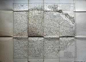
Carte Générale du Royaume de Bohęme, du Duché de Silésie et des Marquisats de Moravie et de Lusace
Edité par Chez Daumont, ŕ Paris, 1757
Livre
Carte Entoilée. Etat : Etat Satisfaisant. Carte dressée sur les mesures géométriques de Muller, Vieland et autres, et soumise aux observations astronomiques par Tobie Majer, mathématicien, et publiée par les héritiers d'Homanne. Une carte gravée sur cuivre et aux frontičres coloriées d'environ 56x46 centimčtres, ornée des blasons des quatre états; échelles graduées en milles d'Allemagne, milles communs de Silésie, grands milles de Silésie et ordinaires de Bohęme, lieues communes de France, toises de Paris. Présente une grande déchirure le long d'un pli vertical sur 22 centimčtres et de petites déchirures au croisement des plis verticaux et des plis horizontaux. L'impression reste trčs fraiche et l'avers de la carte n'est presque pas taché. Poids: 50 grammes.
-

Carta geografica, cm. 60 x 49 ca., colorata. Riquadro in alto a sin. raffigurante la parte settentrionale della Polonia. Pregevole cartiglio in alto a destra, con scala.
-
Landgravia Thuringiae Tabula Generalis in suos Principatcs et Sta accurate divi
Edité par Amsterdam, 1738
Vendeur : Alexandre Antique Prints, Maps & Books, Toronto, ON, Canada
Membre d'association : ABAC ILAB
Evaluation du vendeur :

Size : 497x587 (mm), 19.5x23.125 (Inches), Original Hand Coloring Very Good; light dampstain on lower margin.
-
Ducatus Brunsuicensis in tres suos Principatus Calenbergicum sc. Grubenhag & Guelpherbitanum disctincte divisi, nec non Episcopatus Hildesiensis, Pr. Halber. Comitatus Schauenburgici, aliorum q3 consiniorum exacta Tabula
Edité par Amsterdam, 1738
Vendeur : Alexandre Antique Prints, Maps & Books, Toronto, ON, Canada
Membre d'association : ABAC ILAB
Evaluation du vendeur :
Size : 518x590 (mm), 20.375x23.25 (Inches), Original Hand Coloring Very Good; some very light occasioanl browning; mainly on the right and upper margins.
-
Tabvla Generalis Holsatiae complectens Holsatiae Dithmarsiae Stormariae et Vagriae Dvcatvs
Edité par Amsterdam, 1738
Vendeur : Alexandre Antique Prints, Maps & Books, Toronto, ON, Canada
Membre d'association : ABAC ILAB
Evaluation du vendeur :
Size : 487x580 (mm), 19.125x22.875 (Inches), Original Hand Coloring Very Good; two very light dampstains on the lower margin (on either side of the fold), not entering the image; slight darkening of the lower right corner of the map.
-
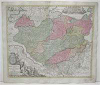
![Image du vendeur pour Erster und Groster Theil des Gantzen Hochlobi Franckischen Craisses in welchem die Bisthumer Bamberg Wurtzburg und Aichstett, die Margger Culmbach und onoltzbach das Hertzogt Coburg, Furstent: Schwartzenberg, Graffisch, Hobenlo, Castel , Limburg [.] mis en vente par Alexandre Antique Prints, Maps & Books](https://pictures.abebooks.com/inventory/md/md1246591149.jpg)
Erster und Groster Theil des Gantzen Hochlobi Franckischen Craisses in welchem die Bisthumer Bamberg Wurtzburg und Aichstett, die Margger Culmbach und onoltzbach das Hertzogt Coburg, Furstent: Schwartzenberg, Graffisch, Hobenlo, Castel , Limburg [.]
Edité par Amsterdam, 1738
Vendeur : Alexandre Antique Prints, Maps & Books, Toronto, ON, Canada
Membre d'association : ABAC ILAB
Evaluation du vendeur :
Carte
Etat : Very Good. Size : 568x500 (mm), 22.375x19.625 (Inches), Original Hand Coloring.
-
Ducatus Mediolani una cum Confinys accurata Tabula exhibns auctus et amedatus
Edité par Amsterdam, 1738
Vendeur : Alexandre Antique Prints, Maps & Books, Toronto, ON, Canada
Membre d'association : ABAC ILAB
Evaluation du vendeur :
Carte
Size : 490x583 (mm), 19.25x23 (Inches), Original Hand Coloring Very Good; one light dampstain on lower left margin. Some light darkening of the lower right corner of the page.
-

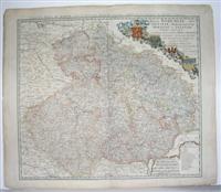
S. R. I. Circvlvs Avstriacvs quem componunt Archid. Avstriae, Dvcatvs Stiriae, Carinthiae, Carinoliae, Comit. Tyrolensis, ditionsque Sveviae austriacae, cum suis confinus a Tobia Majero, Math. Cult. Letitime designatus
Edité par Nuremberg, 1747
Vendeur : Alexandre Antique Prints, Maps & Books, Toronto, ON, Canada
Membre d'association : ABAC ILAB
Evaluation du vendeur :
Carte
Etat : Very Good. Size : 476x532 (mm), 18.75x20.875 (Inches), Original Hand Coloring.
-
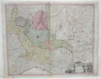
Regni Bohemiae, Dvc. Silesiae, Marchionatvvm Moraviae et Lvsatiae Tabula generalis. Ex mensurationibus geodeticis Mulleri, Wielandii aliorumque ad normam observationaum astronomicarum adaptatis de-prompta et designata
Edité par Nuremberg, 1747
Vendeur : Alexandre Antique Prints, Maps & Books, Toronto, ON, Canada
Membre d'association : ABAC ILAB
Evaluation du vendeur :
Carte
Etat : Very Good. Size : 495x495 (mm), 19.5x22.625 (Inches), Original Hand Coloring.
-
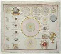
Schematismvs Geographiae Mathematicae, id est, repraesentatio figurarum in quantum ad aliqualem globi terraquei et mapparum intelligentiam in gratiam juventutis erudiendae facere possunt, expositionem ipsarum tradente
Edité par Nuremberg, 1753
Vendeur : Alexandre Antique Prints, Maps & Books, Toronto, ON, Canada
Membre d'association : ABAC ILAB
Evaluation du vendeur :
Carte
Etat : Excellent. Size : 455x550 (mm), 17.875x21.625 (Inches), Hand Colored.
-

Statvs Ecclesiastici nec non Magni Dvcatvs Toscanae Nova Tabvla Geographica secndum principia legitimae Delineationis descripta a Tob. Majero, Societ. Geogr. Sodati curantibus Homannianis Heredibus
Edité par Nuremberg, 1748
Vendeur : Alexandre Antique Prints, Maps & Books, Toronto, ON, Canada
Membre d'association : ABAC ILAB
Evaluation du vendeur :
Carte
Etat : Very Good. Size : 496x570 (mm), 19.5x22.375 (Inches), Hand Colored.
-
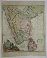
Peninsula Indiae citra Gangem oc est. Orae Celeberrimae Malabar & Coromandel cum adjacente Insula non mimus celebratissima Ceylon
Edité par Nuremburg, 1733
Vendeur : Alexandre Antique Prints, Maps & Books, Toronto, ON, Canada
Membre d'association : ABAC ILAB
Evaluation du vendeur :
Carte
Etat : Very Good. Size : 565x500 (mm), 22.25x19.625 (Inches), Hand Colored, 0.
-
Americae Mappa generalis Secundum legitimas projectionis stereo-graphicae regulas relationesque recentissimas et observationes socioru Acad. Reg. Scquae Parisiis et aliorumque auctorum nec non secundum mentem
Edité par Nuremberg, 1746
Vendeur : Alexandre Antique Prints, Maps & Books, Toronto, ON, Canada
Membre d'association : ABAC ILAB
Evaluation du vendeur :
Carte
Etat : Excellent. Size : 491x570 (mm), 19.375x22.375 (Inches), Original Hand Coloring.
