Montant total (1 article articles) :
Destination de la commande :

J CAREZ (10 résultats)
Passer aux résultats principaux de la recherche
Type d'article
- Tous les types d'articles
- Livres (7)
- Magazines & Périodiques
- Bandes dessinées
- Partitions de musique
- Art, Affiches et Gravures (2)
- Photographies
- Cartes (1)
-
Manuscrits &
Papiers anciens
Etat
- Tous
- Neuf
- Ancien ou d'occasion
Reliure
- Toutes
- Couverture rigide
- Couverture souple
Particularités
- Edition originale
- Signé
- Jaquette
- Avec images (9)
- Sans impression ŕ la demande
Pays
Evaluation du vendeur
-
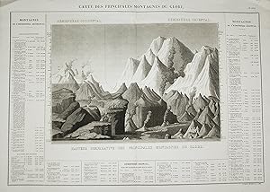
Carte des Principales Montagnes du Globe" - World's mountains Berge chart
Edité par Paris, 1825
Vendeur : Antiquariat Steffen Völkel GmbH, Seubersdorf, Allemagne
Membre d'association : ILAB VDA
Evaluation du vendeur :

Art / Affiche / Gravure
Original Kupferstich von J. Carez von c. 1825. -- Blatt-Format: ca. 70 x 54 cm -- gut erhalten. || Original copper engraving by J. Carez from 1825. Beautiful chart comparing the relative heights of the world's mountains. --in good condition. | Original! - Kein Nachdruck! - Keine Kopie! | This is an original! - No reprint! - No copy! Sprache: Französisch Gewicht in Gramm: 1500.
-
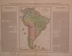
Carte Geographique, Statistique et Historique de l'Amerique Meridionale
Edité par Buchon, Jean Alexandre, Paris, 1825
Vendeur : Argosy Book Store, ABAA, ILAB, New York, NY, Etats-Unis
Membre d'association : ABAA ILAB
Evaluation du vendeur :
unbound. Etat : very good. Carez, J. (illustrateur). Map. Engraving with original hand coloring. Image measures 16" x 11.75", image plus text measures 18" x 24.75". Exquisite impression with great detail. Includes historical and cultural information in French. Two small holes in centerfold. From the French (1825) edition of Carey and Lea's 1822 "A Complete Historical, Chronological, and Geographical American Atlas".
-
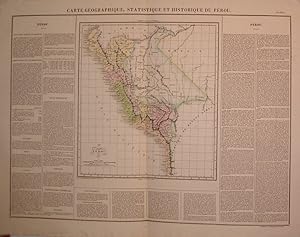
Carte Geographique, Statistique et Historique du Perou
Edité par Buchon, Jean Alexandre, Paris, 1825
Vendeur : Argosy Book Store, ABAA, ILAB, New York, NY, Etats-Unis
Membre d'association : ABAA ILAB
Evaluation du vendeur :
unbound. Etat : very good. J. Carez (illustrateur). Map. Engraving with original hand coloring. Image measures 13.5" x 12.25", image plus text measures 18.5" x 24.5". Includes historical and cultural information in French. Some wear along edges. From the French (1825) edition of Carey and Lea's 1822 "A Complete Historical, Chronological, and Geographical American Atlas".
-
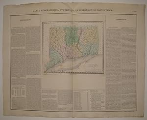
Carte Geographique, Statistique et Historique du Connecticut
Edité par Buchon, Jean Alexandre, Paris, 1825
Vendeur : Argosy Book Store, ABAA, ILAB, New York, NY, Etats-Unis
Membre d'association : ABAA ILAB
Evaluation du vendeur :
unbound. Etat : very good(+). J. Carez (illustrateur). Map. Engraving with original hand coloring. Image measures 9.5" x 11 3/8", image plus text and title measures 19" x 24". Nicely detailed map of Connecticut divided into counties and townships. Includes historical and cultural information in French. Minor toning to edges, crease to top center. Light scattered staining. From the French (1825) edition of Carey and Lea's 1822 "A Complete Historical, Chronological, and Geographical American Atlas".
-
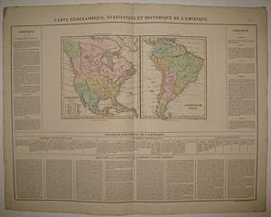
Carte Geographique, Statistique et Historique de l'Amerique
Edité par Buchon, Jean Alexandre, Paris, 1825
Vendeur : Argosy Book Store, ABAA, ILAB, New York, NY, Etats-Unis
Membre d'association : ABAA ILAB
Evaluation du vendeur :
unbound. Etat : very good(+). J. Carez (illustrateur). Map. Engraving with original hand coloring. Image measures 8.25" x 14 7/8", image plus text and title measures 18 7/8" x 25 3/8". Fantastic double page map of North and South America, displayed side by side. Shows states, towns, waterways and topographical features. Includes historical and cultural information in French. From the French (1825) edition of Carey and Lea's 1822 "A Complete Historical, Chronological, and Geographical American Atlas". Minor overall wear, slight crease to upper left corner.
-
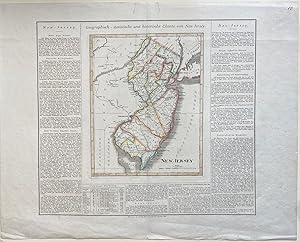
Geograpisch-statistische und historische Charte von Neu-Jersey
Edité par Geographischen Instituts, Weimar, 1825
Vendeur : Argosy Book Store, ABAA, ILAB, New York, NY, Etats-Unis
Membre d'association : ABAA ILAB
Evaluation du vendeur :
unbound. J. Carez (illustrateur). Map. Engraving with original hand coloring. Image measures 11 3/4" x 9 1/4", sheet measures 19 1/4" x 24 1/2" Finely engraved double-page map of New Jersey. Shows counties, towns, waterways, topographical features, and roads. Includes historical and cultural information in German. This map appeared in the rare German edition of Carey and Lea's 1822 "A Complete Historical, Chronological, and Geographical American Atlas", published by the Weimar Geographischen Instituts. In very good condition. Minor wear to margin and centerfold, and two closed tears at upper margin, not affecting the image. Hard to find.
-
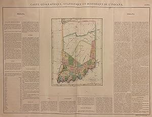
Carte Geographique, Statistique et Historique de L'Indiana
Edité par Buchon, Jean Alexandre, Paris, 1825
Vendeur : Argosy Book Store, ABAA, ILAB, New York, NY, Etats-Unis
Membre d'association : ABAA ILAB
Evaluation du vendeur :
unbound. Carez, J. (illustrateur). Map. Engraving with original hand coloring. Image measures 11" x 8 3/8". Map plus text measures 18" x 24" Fascinating map of Indiana from the French (1825) edition of Carey and Lea's 1822 "A Complete Historical, Chronological, and Geographical American Atlas", showing early county divisions. The southern half of the state is divided into counties and townships, while the northern half of the state remains largely indigenous territory, dominated by Wabash County, Delaware County, and an unnamed territory in the north separated by what is labeled as "Indian boundary". The Kickapoo and Shawanese Indians occupied the northern part of the state, while the Pinkashaw, Miami, and Mascontin Indians occupy Wabash County, and the Delaware Indians reside in Delaware County. In the southern half of the state, various boundary lines transect the counties, indicating the "Old Indian Line" and the lines of Harrison's purchase. Birkbeck's Prairie and Town are also shown. Shows towns, major routes and waterways. Includes information pertaining to history, geography, climate and demographics. Text is in French. The Philadelphia-based firm of Carey & Lea of Philadelphia was one of the most important publishers in the early 19th-century United States. Run by Mathew Carey (1760-1839) and Isaac Lea (1792-1886), the company worked with both books and maps, specializing particularly in political commentary. Their "Complete Historical, Chronological, and Geographical American Atlas," first published in 1822, not only contained some of the earliest maps of western states being admitted to the Union, it also provided ample information on those states. As a result, provides an invaluable window into the country's history. Jean Alexandre Buchon (c. 1791-1846) was a French publisher based in Paris. He is best known for his 1825 French edition of Carey & Lea's American Atlas.
-

Carte des Principales Montagnes du Globe
Edité par J.A. Buchon c. 1825, Paris, 1825
Vendeur : Alexandre Antique Prints, Maps & Books, Toronto, ON, Canada
Membre d'association : ABAC ILAB
Evaluation du vendeur :

Carte
Etat : Very Good. A beautiful chart comparing the relative heights of the world's mountains. Divided by hemisphere. J. Carez (fl. c. 1815 - 1850) was a Paris based book, atlas and map publisher during in the early 19th century. , Size : 443x645 (mm), 17.44x25.39 (Inches), Hand Colored, 0.
-
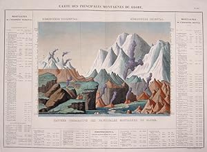
Carte des Principales Montagnes du Globe.
Edité par Artist: Carez J ( - 1850 ) Paris; issued in: Paris; Carez J ( 1815 - 1850 ) Paris; J Carez (c 1815 - 1850) was a book atlas and map publisher actived in the early 19th century Little is known of Carez's life He is best known for his publication of the French edition of H C Carey and I Lea's important Complete Historical Chronological And Geographical American Atlas, 1815
Vendeur : Antique Sommer& Sapunaru KG, München, Allemagne
Membre d'association : ILAB VDA
Evaluation du vendeur :

Art / Affiche / Gravure
Technic: Copper print; colorit: colored; condition: Perfect condition; size (in cm): 46 x 64,5; Decorative an informative chart of the world's mountains. Divided into the Western Hemisphere mountains, on the left and the mountains of the Eastern Hemisphere, on the right . Also includes the relative elevations of important cities, monuments, etc. Unlike most comparative charts issued in the mid 19th century, this chart includes a reference table as part of the map itself. Lists Dalhgari, in Nepal, as the world's tallest mountain, but also features smaller mountains that today serve as sky resorts such as Mt. Mansfield and Killington in Vermont, Mt. Monandnock and Mt. Washington in New Hampshire and Saddleback in Massachusetts. This was originally published in the 1825 French Edition of Carey , Lea's 1822. - A Complete Historical.American Atlas, entitled Atlas Géographique. Statistique, Historique et Chronologique des Deux-Amériques et des îles adjacentes-.This map comes from Bouchon, J. A. C. and Carez, J., -Atlas geographique, statistique, historique et chronologique des deux Ameriques et des iles adjacentes; traduit de l'atlas execute en Amerique d'apres Lesage, avec de nombreuses corrections et augmentations, par Jean Alexandre Buchon., 1825.-.
-
ATLAS GEOGRAPHIQUE, STATISTIQUE, HISTORIQUE ET CHRONOLOGIQUE DES DEUX AMERIQUES ET DES ISLES ADJACENTES
Edité par Buchon, Jean Alexandre, Paris, 1825
Vendeur : Argosy Book Store, ABAA, ILAB, New York, NY, Etats-Unis
Membre d'association : ABAA ILAB
Evaluation du vendeur :
unbound. J. Carez (illustrateur). Atlas. Folio (22 x 15 inches). 63 double-page plates, including 51 double-page maps with beautiful contemporary hand coloring. Black half leather with gilt title and marbled board covers. Very small stamp on verso of title page. Publishers crease on plate 24 (Maryland), minor soiling on plate 32 (Tennessee), stain on plate 39 (Arkansas Territory), page number misprint on Brazil map. Most of this atlas is devoted to the United States and its territories. Thick paper and high quality original color. From the French (1825) edition of Carey and Lea's 1822 "A Complete Historical, Chronological, and Geographical American Atlas".