
Montant total (1 article articles) :
Destination de la commande :

J W FOSTER, J D WHITNEY (18 résultats)
Passer aux résultats principaux de la recherche
Type d'article
- Tous les types d'articles
- Livres (14)
- Magazines & Périodiques
- Bandes dessinées
- Partitions de musique
- Art, Affiches et Gravures (2)
- Photographies
- Cartes (2)
-
Manuscrits &
Papiers anciens
Etat
Reliure
Particularités
Pays
Evaluation du vendeur
-
Report on the Geology and Topography of a Portion of the Lake Superior Land
Edité par Forgotten Books, 2017
ISBN 10 : 1334481083ISBN 13 : 9781334481086
Livre impression ŕ la demande
Paperback. Etat : New. Print on Demand. Excerpt from Report on the Geology and Topography of a Portion of the Lake Superior Land District, in the State of Michigan. About the Publisher, Forgotten Books publishes hundreds of thousands of rare and classic books. This book is a reproduction of an important historical work. Forgotten Books uses state-of-the-art technology to digitally reconstruct the work, preserving the original format whilst repairing imperfections present in the aged copy. In rare cases, an imperfection in the original, such as a blemish or missing page, may be replicated in our edition. We do, however, repair the vast majority of imperfections successfully; any imperfections that remain are intentionally left to preserve the state of such historical works. This text has been digitally restored from a historical edition. Some errors may persist, however we consider it worth publishing due to the work's historical value. The digital edition of all books may be viewed on our website before purchase. print-on-demand item.
-
Report of the Geology the Lake Superior Land District, Vol. 2 (Classic Reprint)
Edité par Forgotten Books, 2019
ISBN 10 : 1332760821ISBN 13 : 9781332760824
Livre impression ŕ la demande
Paperback. Etat : New. Print on Demand. Excerpt from Report of the Geology the Lake Superior Land District. About the Publisher, Forgotten Books publishes hundreds of thousands of rare and classic books. This book is a reproduction of an important historical work. Forgotten Books uses state-of-the-art technology to digitally reconstruct the work, preserving the original format whilst repairing imperfections present in the aged copy. In rare cases, an imperfection in the original, such as a blemish or missing page, may be replicated in our edition. We do, however, repair the vast majority of imperfections successfully; any imperfections that remain are intentionally left to preserve the state of such historical works. This text has been digitally restored from a historical edition. Some errors may persist, however we consider it worth publishing due to the work's historical value. The digital edition of all books may be viewed on our website before purchase. print-on-demand item.
-

REPORT ON THE GEOLOGY OF THE LAKE SUPERIOR LAND DISTRICT Part II: the Iron Region Together with the General Geology
Edité par A. Boyd Hamilton, 1851
Vendeur : A Squared Books (Don Dewhirst), South Lyon, MI, Etats-Unis
Evaluation du vendeur :

Livre
hardcover. Etat : Fair. 1851; Washington; Ex-library with typical library markings; tan cloth covered boards with black titles; edge worn and rubbed; interior is toned; 8vo, 7 3/4"-9 3/4" tall; 406 pages with all 35 plates but missing maps.
-
Preliminary Report of the Inland Waterways Commission February 3, 1908
Edité par Government Printing Office, Washington, D.C, 1908
Vendeur : Dorley House Books, Inc., Hagerstown, MD, Etats-Unis
Evaluation du vendeur :

Edition originale
Hardcover. Etat : Very Good. Fold-out Maps 2 large in Rear Pockets and Many in Text (illustrateur). 1st. black c; 701 clean, unmarked pages; contains the Gallatin Report on progress and use of Canals, as well as reports on water power, transportation comparisons with railroads, etc Size: 8 vo.
-
REPORT ON THE GEOLOGY AND TOPOGRAPHY OF A PORTION OF THE LAKE SUPERIOR LAND DISTRICT 31st Congress, 1st Session
Edité par Washington, 1850
Vendeur : John K King Used & Rare Books, Detroit, MI, Etats-Unis
Evaluation du vendeur :
Hardcover. Etat : Good. 1 of 4 foldout maps, 12 plates, text illus., 9 x 6", blindstamped brown cloth, gilt lettering on spine, 224pp. Covers poor, toning, scattered foxing, map torn. Textblock tight. Only map present is Lake Superior.
-
REPORT ON THE GEOLOGY OF THE LAKE SUPERIOR LAND DISTRICT PART II THE IRON REGION
Edité par Senate Documents, DC, 1851
Vendeur : Rocks of Ages, Inc., Noblesville, IN, Etats-Unis
Evaluation du vendeur :
Livre
Original Embossed Cloth. Etat : Very Good. Senate Document 4, pp xvi + 406 with 36 plates, some tinted; 38 figures. The second part of Foster and Whitney's well-illustrated report on the lake superior land district, this portion covers the iron region.
-
Report on the Geology of the Lake Superior Land District Part II The Iron Region together with the General Geology
Edité par A Boyd Hamilton, Washington D.C., 1851
Vendeur : Great Matter Books, Grand Rapids, MI, Etats-Unis
Evaluation du vendeur :
Livre
Hardcover. Etat : Fair. A Fair hardcover copy with decorative cloth and gilt spine lettering. Covers are well worn, almost all edges and corners worn through, splits in cloth at hinge, spine lettering dulled but still readable. Internally, hinges starting with front hinge a little weak, rear hinge still strong. Previous owner's bookplate to front paste down. Text is strong and clear, a few random small pencil check marks in the text. All plates present and clean, bound at rear of book. 3 referenced maps are missing. A solid though well worn copy. All of our books are individually inspected and described. Never ex-lib unless explicitly described as such.
-
Report on the Geology of the Lake Superior Land District: Part II. The Iron Region, Together with the General Geology.
Edité par United States Senate / A. Boyd Hamilton - printer, Washington, D. C., 1851
Vendeur : West Side Book Shop, ABAA, Ann Arbor, MI, Etats-Unis
Membre d'association : ABAA ILAB MWABA
Evaluation du vendeur :
Edition originale
Hardcover. Etat : Good. No Jacket. First Edition. xvi, 406 pp. + XXV Plates, Introduction, list of sketches of scenery, list of plates of fossils, I. Classification and Nomenclature of the Rock; II. The Azoic System; III. Granite Rocks of the Azoic Period; IV. The Iron Ores and Associated Rocks; V. Economic Geology of the Azoic Series; VI. Composition of the Trappean Rocks; VII. Mineralogy; VIII. - IX (by James Hall). Lower Silurian System; X. Upper Silurian and Devonian Series by James Hall; XI. Miscellaneous Observations on the Palaeozoic Series; XII. Chemistry and Economic Geology of the Palaeozoic Series; XIII. Description of New and Rare Species of Fossils from the Palaeozoic Series (by James Hall); XIV. - XVI. On the Superficial Deposits of this District (by E. Desor); XVII. On the Elevation of Mountain Chains; XVIII. Parallelism of the Palaeozoic Deposits of Europe and American (by James Hall); XIX. On the Observed Fluctuations of the Surfaces of the Lakes (by Charles Whitlesey; XX. Magnetic Variations --- Comparison of Terrestial and Astronomical Measurements (by Charles Whittlesey; XXI. Botany (by W. D. Whitney; Appendix: The Jesuit Relations, et al.; index; The Plates (including four fold-outs). First Printing, March 13, 1851. Scarce Title. Inked name on prelim. Cloth worn bottom edges, boards show approaching the forecorners, less so to top edge, with faded spine, and age-toning to text block edges. Clean, tight and strong binding with no underlining, highlighting or marginalia. Brown cloth with stamped decorative front board and spine, and rubbed faded black lettering to spine. Size: Thick 8vo. Book.
-
GEOLOGICAL MAP OF THE DISTRICT BETWEEN KEWEENAW BAY AND CHOCOLATE RIVER, Lake Superior, Michigan.
Edité par USGPO: Washington, D.C., 1849
Vendeur : John K King Used & Rare Books, Detroit, MI, Etats-Unis
Evaluation du vendeur :
Map is 20 x 24, folds down to fit in 9.5 x 5.75 gilt lettered cloth folder, map is lightly colored, misfolded, some edge tears, holes at folds, soiling and wear; folder is worn, spine-sunned; this is the only map remaining in folder (although the title says Maps). From Charles T. Jackson's REPORT ON THE GEOLOGICAL AND MINERALOGICAL SURVEY OF THE MINERAL LANDS OF THE UNITED STATES IN THE STATE OF MICHIGAN (1849). Still, would look decent with a little TLC. Contrary to earlier reports, the Chocolate River is not made up of real chocolate.
-
Report on the Geology and Topography of a Portion of the Lake Superior Land District In the State of Michigan
Edité par Washington
Etat : Good. Hardcover; House of Reps; 1850; Professionally rebound in blue cloth with tan endpapers. Missing plate #6 of 12, 3 fold out maps of which all have some degrees of tears, prev. Owners name across top of title page. Foxing on pages as well as water damage. Blank front page has 3" water stain. Still held into the binding well, but the pages are fragile. ; 8vo 8" - 9" tall; 221 p.
-
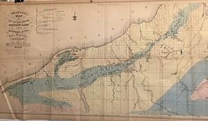
MAP: Geological Map of the District Between Portage Lake and Montreal River, Lake Superior, Michigan
Edité par Foster & Whitney, NY, 1849
Vendeur : Dorley House Books, Inc., Hagerstown, MD, Etats-Unis
Evaluation du vendeur :
Art / Affiche / Gravure
Unbound. Etat : Very Good. Handcolored Map (illustrateur). lovely handcolored 1849 map; marginal repair at upper left top edge Size: 19 .5" x 30".
-
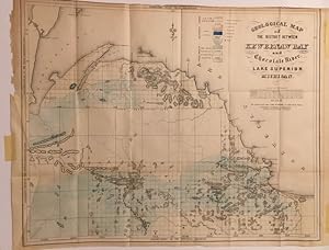
MAP: Geological Map of The District Between Kewbenaw Bay and Chocolate River, Lake Superior, Michigan
Edité par Foster & Whitney, NY, 1849
Vendeur : Dorley House Books, Inc., Hagerstown, MD, Etats-Unis
Evaluation du vendeur :
Art / Affiche / Gravure
Unbound. Etat : Very Good. Handcolored Map (illustrateur). 25" x 20" handcolored Foster & Whitney map of the Upper Peninsula, Michigan Copper district between the Kewbenaw Bay and Chocolate River, Lake Superior Size: 25" x 20".
-
REPORT ON THE GEOLOGY OF THE LAKE SUPERIOR LAND DISTRICT PART II THE IRON REGION
Edité par A. Boyd Hamilton: Washington, 1851
Vendeur : John K King Used & Rare Books, Detroit, MI, Etats-Unis
Evaluation du vendeur :
Hardcover. Etat : Very Good. 36/36 plates (including a duplicate of VI), 8.5 x 5.5", brown buckram, gilt spine lettering, 406pp. All the plates, with the exception of the frontis, have been bound in at the rear and have pencil notes identifying their original locations, several pages heavily toned, occasional pencil notes in text, offsetting, foxing, spotting else good. Textblock tight.
-
Report on the Geology and Topography of a Portion of the Lake Superior Land District, in the State of Michigan. Part I. Copper Lands. (1850)
Edité par Washington, D.C., for the House of Representatives
Vendeur : Powell's Bookstores Chicago, ABAA, Chicago, IL, Etats-Unis
Membre d'association : ABAA ILAB
Evaluation du vendeur :
Etat : Used - Very Good. 1850. Hardcover. HR Doc. 69, 31st Congress, 1st Session (1850). Orig. dec. cloth, 224 pp. With 12 plates (8 tinted) and a folding facsimile map. (Does not include the large folding maps which were issued in a separate Atlas volume). Modest wear to cloth; some age toning to text-block. Well preserved overall. Very Good.
-
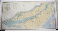
Geological Map of the District Between Portage lake and Montreal River
Edité par P.S. Duval's Steam Lith Press, Philadelphia, 1847
Vendeur : Alexandre Antique Prints, Maps & Books, Toronto, ON, Canada
Membre d'association : ABAC ILAB
Evaluation du vendeur :

Carte
Etat : Very Good. Size : 485x945 (mm), 19.125x37.125 (Inches), Hand Colored.
-
Geological Map of Neweenaw Point
Edité par US, , c.1847., 1847
Vendeur : Alexandre Antique Prints, Maps & Books, Toronto, ON, Canada
Membre d'association : ABAC ILAB
Evaluation du vendeur :
Size: , . Original Hand Coloring, Very Good.
-

Geological Map of the Lake Superior Land District in the State of Michigan
Edité par J. Adkerman, New York, 1847
Vendeur : Alexandre Antique Prints, Maps & Books, Toronto, ON, Canada
Membre d'association : ABAC ILAB
Evaluation du vendeur :
Carte
Etat : Very Good. Size : 645x990 (mm), 25.375x39 (Inches), Original Hand Coloring.
-
Report on the geology and topography of a portion of the Lake Superior land district, in the State of Michigan, [&c.]. Copper Lands. [WITH THREE COLORED MAPS, NOT USUALLY PRESENT.] [First edition].
Edité par Washington, House of Representatives, 1850
Vendeur : Olde Geologist Books, Pawcatuck, CT, Etats-Unis
Membre d'association : SNEAB
Evaluation du vendeur :
Livre Edition originale
Hardcover. Etat : Near Fine. 1st Edition. House Ex. Doc. No. 69, octavo, 224 p., 12 engraved plates (most tinted), 4 folding maps (3 colored), and 55 text figures. ***CONTENT: In the 1840's, reports of extensive copper deposits on Michigan's upper peninsula led to a rush of prospectors. This Congressional report was one of the earliest to describe the geography, geology and mineral resources of the region, which for decades supplied much of the nation's copper output. Chapters provide a historical sketch of explorations, and consideration of geography, climate, geological details, mines and mining techniques, veins, ores and metallurgy, surficial deposits, and more. The splendid illustrations show scenery, bedrock exposures, mine workings, etc. Loosely inserted in this copy are the three exquisite hand-colored geological maps called for on page 58 of the text: 1) "Geological map of Keweenaw Point, Lake Superior, Michigan" (21.75 x 12 inches). This map shows rock types in five colors, copper-bearing "mineral land", active and abandoned mines, furnaces, and more. 2) "Geological map of the district between Portage Lake and Montreal River, Lake Superior, Michigan" (31 x 16.5 inches). This map shows geology in seven colors, as well as mineral lands and mines. 3) "Geological map of Isle Royale, Lake Superior, Michigan" (25.5 x 18 inches). This map updates Jackson's geological map of 1847, and pinpoints numerous mineral-rich sites and mines. *Important note: These are NOT the three maps found in the authors' map portfolio, separately issued in 1851. ***CONDITION: A complete, near-Fine, exceptionally clean copy in the original embossed and blind-decorated brown cloth. The spine ends are well preserved and the gilt lettering on the backstrip is particularly crisp and bright. Joints and hinges solid, binding firm. Save for minor offsetting here and there in the text, the pages, plates and illustrations are fresh, clean and bright. The three colored maps are very clean, with vivid colors and expert reinforcement to tiny splits. No previous ownership indications. This is one of the most handsome copies of this report that I have seen, and it is exceedingly scarce with the three colored maps. BMNH 2172. Prime 20. Hazen 3940 (in part). Marcou 364, 365, 366. International shipping will be extra for this volume, but only at my cost.

![Image du vendeur pour Report on the geology and topography of a portion of the Lake Superior land district, in the State of Michigan, [&c.]. Copper Lands. [WITH THREE COLORED MAPS, NOT USUALLY PRESENT.] [First edition]. mis en vente par Olde Geologist Books](https://pictures.abebooks.com/inventory/md/md31263380110.jpg)