
Montant total (1 article articles) :
Destination de la commande :

JAN JANSSON JANSSONIUS (29 résultats)
Passer aux résultats principaux de la recherche
Type d'article
- Tous les types d'articles
- Livres (16)
- Magazines & Périodiques
- Bandes dessinées
- Partitions de musique
- Art, Affiches et Gravures (2)
- Photographies
- Cartes (11)
-
Manuscrits &
Papiers anciens
Etat
- Tous
- Neuf
- Ancien ou d'occasion
Reliure
- Toutes
- Couverture rigide
- Couverture souple (1)
Particularités
- Edition originale (1)
- Signé
- Jaquette
- Avec images (18)
- Sans impression ŕ la demande
Pays
Evaluation du vendeur
-
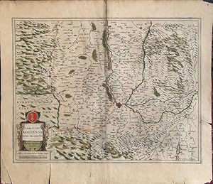
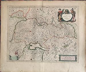
Namurcum Comitatus Auctore Iohann Surhonio [17th Century Map of Belgium]
Edité par Amsterdam: J. Blaeu., 1660
Vendeur : Sequitur Books, Boonsboro, MD, Etats-Unis
Membre d'association : IOBA
Evaluation du vendeur :

Carte
Map. Etat : Fair. [17th Century Map of Belgium] 20 1/8" x 23 3/4". (57 x 46.5 cm in frame) Map under glass in wood frame. Toned. Light crease in center. Jansson (Dutch 1588-1664). Depicting the region around the city of Namur at the confluence of the Meuse and Sambre Rivers. Based on the once secret map of Jacques Surhon (ca. 1555). Copper engraved on laid paper, decorated with figurative title cartouche featuring a coat of arms and four putti, an unusual compass flanked by a surveyor, and a large scale of miles cartouche. Van der Krogt (Vol. II) #3340:2.2. This is an oversized or heavy book, which requires additional postage for international delivery outside the US.
-
AN ORIGINAL ENGRAVED MAP OF Herefordshire. Herefordia Comitatus vernacule Hereford Shire
Edité par Atlas Novus Ca 1690, 1690
Vendeur : PROCTOR / THE ANTIQUE MAP & BOOKSHOP, DORCHESTER, Royaume-Uni
Membre d'association : PBFA
Evaluation du vendeur :
Carte
Lg.map (engr.surface 20.5 x 15.5 inches). In ivory mount. Black & Gilt glazed frame. Framed Size 28 x 23 inches An attractive and decorative map in very good condition. Nicely Original hand-coloured. he map has a decorative cartouche, illustrations of various coats of arms and cherubs in the top right corner and cherubs and a man making use of the measurement legend in the bottom left corner. Jan Jansson Jr (1588-1664), or Johannes Janssonius, was the son of a bookseller and publisher who had worked with Jodocus Hondius Sr. From about 1633 onwards, his imprint appears on the title-pages of the Mercator-Hondius "Atlas", in conjunction with his brother-in-law, Henry, as they re-issued their "Atlas" in competition with the Blaeus.
-

Dwinae Fluvii nova descriptio.
Edité par Amsterdam,, 1645
Vendeur : Antiquariat J.J. Heckenhauer e.K., ILAB, Tuebingen, Allemagne
Membre d'association : ILAB VDA
Evaluation du vendeur :

Edition originale
46 x 54 cm (plate), 50 x 59 cm Copper engraving, one leaf. 1 Blatt, verso weiß, verso blanco. ohne Passepartout. Mit Mittelfalte, altkoloriert, hand coloured with a nice cartouche. Small foxing stains in the upper right part, annotings in pencil at the right bottom margin. A good condition, guter Zustand. First printing version by Jansson, (before his death). An uncommon map in three parts, showing Archangelsk in the upper map, on the right side. Sprache: latein. International orders: Please mention, the indicated shipping rates are not weight based and could be higher. We will contact you. Thank you. * 200 Jahre J.J. Heckenhauer *.
-
Territory Basiliensis Nova Descriptio
Edité par [Amsterdam: Jansson, c.1640]., 1640
Vendeur : William Matthews/The Haunted Bookshop, Sidney, BC, Canada
Membre d'association : ABAC ILAB
Evaluation du vendeur :
Copper-engraved map on laid paper, hand-coloured cartouches in lower left corner. Hand-colouring to entire map. Text on the verso in French, heading titled: Le Territoire de BASLE. Hand-coloured initial on verso. Signature mark on verso is IIi. Plate size is 49cm x 38cm, on a sheet measuring 55cm x 48.5cm. Old yellowed tape repair on verso at fold and edges, some splitting at fold, pin holes to margins, tears in lower margin, very good condition. Probably from the French edition of Jansson's "Nouveau Theatre du Monde ou Nouvel Atlas" [c.1640]. Numbered in pencil at upper right with the numeral "67". From WorldCat's description: "The first French editions of the Atlas Novus appeared in three volumes in 1639, a year after the inaugural Latin version. The promptness with which the translation was readied meant that these were largely identical to the Latin original in material and structure, although several revisions were made to the order of contents to better tailor Jansson's offering to the Francophone market: thus, the French part of the Atlas was given new precedence over the Dutch one, and the Spanish and Portuguese chapters were detached from the French section in order to give the latter a stronger thematic coherence than it had previously had. Despite these similarities, the publication of the French editions was quite different from the Latin. After issuing the latter together, by 1639 Jansson and Hondius had resolved to print their own copies of the French title under their own imprints, and this division of resources and duplication of editions has resulted in a distinct, more complex publishing history. Indeed, variations in the stock of plates available to the former partners resulted in two quite separate classes of Atlas, with as many as twenty-five different maps between them, Jansson's typically the more up to date. Matters are further complicated by both Jansson and Hondius' habit of regularly updating their imprints for several years from 1639 onwards, resulting in confusing arrays of dates across the volumes of a single set.".
-
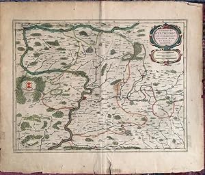
Comitatus Wertheimici Finitimarumque Regionum Nova Et Exacta Descriptio.
Edité par Amsterdam: Jansson, [c.1640]., 1640
Vendeur : William Matthews/The Haunted Bookshop, Sidney, BC, Canada
Membre d'association : ABAC ILAB
Evaluation du vendeur :
Copper-engraved map on laid paper, hand-coloured cartouche in upper right. Hand-colouring to entire map. Imprint at lower margin: "Joannes Janssonius execudit". Text on the verso in French, heading titled Le Comte De WERTHAIM. Hand-coloured initial on verso. Signature mark on verso is YY. Plate size is 50.5cm x 39cm, on a sheet measuring 58cm x 50cm. Old tape repairs to central fold and a few short tears on verso, very good condition. From Volume III of the French edition of Jansson's "Nouveau Theatre du Monde ou Nouvel Atlas" [c.1640]. Numbered in pencil at upper right with the numeral "57". From WorldCat's description: "The first French editions of the Atlas Novus appeared in three volumes in 1639, a year after the inaugural Latin version. The promptness with which the translation was readied meant that these were largely identical to the Latin original in material and structure, although several revisions were made to the order of contents to better tailor Jansson's offering to the Francophone market: thus, the French part of the Atlas was given new precedence over the Dutch one, and the Spanish and Portuguese chapters were detached from the French section in order to give the latter a stronger thematic coherence than it had previously had. Despite these similarities, the publication of the French editions was quite different from the Latin. After issuing the latter together, by 1639 Jansson and Hondius had resolved to print their own copies of the French title under their own imprints, and this division of resources and duplication of editions has resulted in a distinct, more complex publishing history. Indeed, variations in the stock of plates available to the former partners resulted in two quite separate classes of Atlas, with as many as twenty-five different maps between them, Jansson's typically the more up to date. Matters are further complicated by both Jansson and Hondius' habit of regularly updating their imprints for several years from 1639 onwards, resulting in confusing arrays of dates across the volumes of a single set.".
-
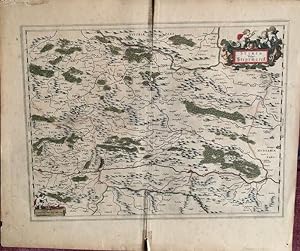
Stiria Vulgo Steyrmarck
Edité par [Amsterdam: Jansson, c.1640]., 1640
Vendeur : William Matthews/The Haunted Bookshop, Sidney, BC, Canada
Membre d'association : ABAC ILAB
Evaluation du vendeur :
Copper-engraved map on laid paper, hand-coloured cartouches in upper right & lower left corners. Hand-colouring to entire map. Text on the verso in French, heading titled: Description Du Duche de STIRIE. Hand-coloured initial and tailpiece on verso. Signature mark on verso is HHHh. Plate size is 51cm x 38.5cm, on a sheet measuring 58cm x 49.5cm. Old yellowed tape repair on verso at fold and edges, some splitting at fold, chipping at lower fold, pin holes to margins, very good condition. Probably from the French edition of Jansson's "Nouveau Theatre du Monde ou Nouvel Atlas" [c.1640]. Numbered in pencil at upper right with the numeral "90". From WorldCat's description: "The first French editions of the Atlas Novus appeared in three volumes in 1639, a year after the inaugural Latin version. The promptness with which the translation was readied meant that these were largely identical to the Latin original in material and structure, although several revisions were made to the order of contents to better tailor Jansson's offering to the Francophone market: thus, the French part of the Atlas was given new precedence over the Dutch one, and the Spanish and Portuguese chapters were detached from the French section in order to give the latter a stronger thematic coherence than it had previously had. Despite these similarities, the publication of the French editions was quite different from the Latin. After issuing the latter together, by 1639 Jansson and Hondius had resolved to print their own copies of the French title under their own imprints, and this division of resources and duplication of editions has resulted in a distinct, more complex publishing history. Indeed, variations in the stock of plates available to the former partners resulted in two quite separate classes of Atlas, with as many as twenty-five different maps between them, Jansson's typically the more up to date. Matters are further complicated by both Jansson and Hondius' habit of regularly updating their imprints for several years from 1639 onwards, resulting in confusing arrays of dates across the volumes of a single set." A map of Styria in Austria, based on Blaeu's map of 1635.
-
Legionis Regnum et Asturiarum Principatus.
Edité par Amsterdam: Jansson, [c.1640]., 1640
Vendeur : William Matthews/The Haunted Bookshop, Sidney, BC, Canada
Membre d'association : ABAC ILAB
Evaluation du vendeur :
Copper-engraved map on laid paper, hand-coloured cartouches in lower right & left corners. Hand-colouring to entire map. Text on the verso in French, heading titled: LEON ET ASTURIE. Hand-coloured initials and tailpiece on verso. Signature mark on verso is E. Plate size is 49cm x 38cm, on a sheet measuring 59cm x 49.5cm. Old paper tape repair on verso at lower fold, some splitting along fold, clean and in very good condition. From Volume III of the French edition of Jansson's "Nouveau Theatre du Monde ou Nouvel Atlas" [c.1640]. Numbered in pencil at upper right with the numeral "4", which corresponds to this title on the contents list provided by WorldCat. From WorldCat's description: "The first French editions of the Atlas Novus appeared in three volumes in 1639, a year after the inaugural Latin version. The promptness with which the translation was readied meant that these were largely identical to the Latin original in material and structure, although several revisions were made to the order of contents to better tailor Jansson's offering to the Francophone market: thus, the French part of the Atlas was given new precedence over the Dutch one, and the Spanish and Portuguese chapters were detached from the French section in order to give the latter a stronger thematic coherence than it had previously had. Despite these similarities, the publication of the French editions was quite different from the Latin. After issuing the latter together, by 1639 Jansson and Hondius had resolved to print their own copies of the French title under their own imprints, and this division of resources and duplication of editions has resulted in a distinct, more complex publishing history. Indeed, variations in the stock of plates available to the former partners resulted in two quite separate classes of Atlas, with as many as twenty-five different maps between them, Jansson's typically the more up to date. Matters are further complicated by both Jansson and Hondius' habit of regularly updating their imprints for several years from 1639 onwards, resulting in confusing arrays of dates across the volumes of a single set." This issue is virtually identical to that issued by Blaeu in 1634, save for the addition of the second scale of distance in the cartouche/table at the lower right (Milliaria Germanica communia), and some minor reworking of the cartouche itself.
-
Territorio Di Bologna
Edité par Amsterdam: Jansson, [1647], 1647
Vendeur : William Matthews/The Haunted Bookshop, Sidney, BC, Canada
Membre d'association : ABAC ILAB
Evaluation du vendeur :
Copper-engraved map on laid paper, hand-coloured cartouches in upper right and lower left corners. Hand-colouring to divisions on map. Imprint at lower right: "Amstelodami, apud Ioannem Ianssonium". Text on the verso in French, heading titled BOLOGNOIS. Signature mark on verso is Eee. Plate size is 52cm x 42.5cm, on a sheet measuring 59cm x 49.5cm. Old tape repairs to central fold on verso, a little splitting at ends along central fold, pin holes in upper corner, very good condition. From Jansson's ATLAS NOVUS of 1647.
-
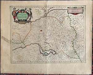
Territorio di Bergamo.
Edité par Amsterdam: Jansson, [c.1640]., 1640
Vendeur : William Matthews/The Haunted Bookshop, Sidney, BC, Canada
Membre d'association : ABAC ILAB
Evaluation du vendeur :
Copper-engraved map on laid paper, hand-coloured cartouches in upper right & left corners. Hand-colouring to entire map. Text on the verso in French, heading titled: BERGAMASC. Hand-coloured initial and tailpiece on verso. Signature mark on verso is L. Imprint at lower right: "Amstelodami Ioannes Ianssonius, Excudit." Plate size is 49cm x 37.5cm, on a sheet measuring 59cm x 48cm. Old paper tape repair on verso at lower fold, yellowed tape on verso at upper fold and left margin, short tears to margins, very good condition. Probably from Volume III of the French edition of Jansson's "Nouveau Theatre du Monde ou Nouvel Atlas" [c.1640]. Numbered in pencil at upper right with the numeral "16". From WorldCat's description: "The first French editions of the Atlas Novus appeared in three volumes in 1639, a year after the inaugural Latin version. The promptness with which the translation was readied meant that these were largely identical to the Latin original in material and structure, although several revisions were made to the order of contents to better tailor Jansson's offering to the Francophone market: thus, the French part of the Atlas was given new precedence over the Dutch one, and the Spanish and Portuguese chapters were detached from the French section in order to give the latter a stronger thematic coherence than it had previously had. Despite these similarities, the publication of the French editions was quite different from the Latin. After issuing the latter together, by 1639 Jansson and Hondius had resolved to print their own copies of the French title under their own imprints, and this division of resources and duplication of editions has resulted in a distinct, more complex publishing history. Indeed, variations in the stock of plates available to the former partners resulted in two quite separate classes of Atlas, with as many as twenty-five different maps between them, Jansson's typically the more up to date. Matters are further complicated by both Jansson and Hondius' habit of regularly updating their imprints for several years from 1639 onwards, resulting in confusing arrays of dates across the volumes of a single set.".
-
Germaniae Veteris
Edité par c. 1603, Amsterdam, 1603
Vendeur : William Chrisant & Sons, ABAA, ILAB. IOBA, ABA, Ephemera Society, Fort Lauderdale, FL, Etats-Unis
Membre d'association : ABAA ESA ILAB
Evaluation du vendeur :
Etat : Very Good. Amsterdam. Very Good. c. 1603. 17th century map in original hand-coloring of Germany, western Poland, western Austria, northern Italy, eastern France, Belgium, the Netherlands and proximal areas showing mountain ranges, forests, bodies of water, towns and cities. Three decorative cartouches. Latin text to verso. Some foxing, otherwise an attractive copy. Please see image. Plate size approximately 15 1/8 x 19 in (385 x 480 mm). Overall size approximately 16 1/2 x 20 1/4 in (420 x 515 mm).; 1 pages; All shipments through USPS insured Priority Mail. .
-
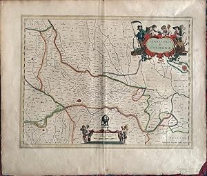
Territorio Di Cremona.
Edité par Amsterdam: Jansson, c.[1640], 1640
Vendeur : William Matthews/The Haunted Bookshop, Sidney, BC, Canada
Membre d'association : ABAC ILAB
Evaluation du vendeur :
Copper-engraved map on laid paper, coloured cartouche in upper right, another at bottom centre. Hand-colouring to margin and divisions on map. Imprint at lower right: "Amstelodami Sumptibus Ioannis Ianssonii". Text on the verso in French, heading titled ESTAT DE MILAN. Hand-coloured large tailpiece on verso. Signature mark on verso is Ff. Plate size is 49cm x 38cm, on a sheet measuring 58cm x 49cm. Old tape repairs to central fold on verso, chip from lower right blank margin, very good condition. From Volume III of the French edition of Jansson's "Nouveau Theatre du Monde ou Nouvel Atlas" [c.1640]. Numbered in pencil at upper right with the numeral "31", which corresponds to this title on the contents list provided by WorldCat. From WorldCat's description: "The first French editions of the Atlas Novus appeared in three volumes in 1639, a year after the inaugural Latin version. The promptness with which the translation was readied meant that these were largely identical to the Latin original in material and structure, although several revisions were made to the order of contents to better tailor Jansson's offering to the Francophone market: thus, the French part of the Atlas was given new precedence over the Dutch one, and the Spanish and Portuguese chapters were detached from the French section in order to give the latter a stronger thematic coherence than it had previously had. Despite these similarities, the publication of the French editions was quite different from the Latin. After issuing the latter together, by 1639 Jansson and Hondius had resolved to print their own copies of the French title under their own imprints, and this division of resources and duplication of editions has resulted in a distinct, more complex publishing history. Indeed, variations in the stock of plates available to the former partners resulted in two quite separate classes of Atlas, with as many as twenty-five different maps between them, Jansson's typically the more up to date. Matters are further complicated by both Jansson and Hondius' habit of regularly updating their imprints for several years from 1639 onwards, resulting in confusing arrays of dates across the volumes of a single set.".
-
Territorio di Brescia et di Crema.
Edité par Amsterdam: Jansson, [c.1640]., 1640
Vendeur : William Matthews/The Haunted Bookshop, Sidney, BC, Canada
Membre d'association : ABAC ILAB
Evaluation du vendeur :
Copper-engraved map on laid paper, hand-coloured cartouches in upper right & both lower corners. Hand-colouring to entire map. Text on the verso in French, heading titled: BRESSAN. Hand-coloured initial on verso. Signature mark on verso is M. Imprint at lower left: "Amstelodami Apud Ioannem Ianssonium." Plate size is 49cm x 39cm, on a sheet measuring 58.5cm x 49.5cm. Old paper tape repair on verso at lower fold, yellowed tape on verso at upper fold, some splitting at fold, pin holes to margins, very good condition. Probably from Volume III of the French edition of Jansson's "Nouveau Theatre du Monde ou Nouvel Atlas" [c.1640]. Numbered in pencil at upper right with the numeral "17". From WorldCat's description: "The first French editions of the Atlas Novus appeared in three volumes in 1639, a year after the inaugural Latin version. The promptness with which the translation was readied meant that these were largely identical to the Latin original in material and structure, although several revisions were made to the order of contents to better tailor Jansson's offering to the Francophone market: thus, the French part of the Atlas was given new precedence over the Dutch one, and the Spanish and Portuguese chapters were detached from the French section in order to give the latter a stronger thematic coherence than it had previously had. Despite these similarities, the publication of the French editions was quite different from the Latin. After issuing the latter together, by 1639 Jansson and Hondius had resolved to print their own copies of the French title under their own imprints, and this division of resources and duplication of editions has resulted in a distinct, more complex publishing history. Indeed, variations in the stock of plates available to the former partners resulted in two quite separate classes of Atlas, with as many as twenty-five different maps between them, Jansson's typically the more up to date. Matters are further complicated by both Jansson and Hondius' habit of regularly updating their imprints for several years from 1639 onwards, resulting in confusing arrays of dates across the volumes of a single set.".
-
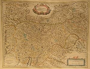
Territorium Tridentinum
Date d'édition : 1660
Vendeur : William Chrisant & Sons, ABAA, ILAB. IOBA, ABA, Ephemera Society, Fort Lauderdale, FL, Etats-Unis
Membre d'association : ABAA ESA ILAB
Evaluation du vendeur :
Etat : Very Good. Very Good. c1660. 17th century map with original, hand-colored outlines of Trento and the Italian Alps. Decorative cartouche. Some foxing, most apparent to margins. Otherwise, a handsome copy. Please see image. Plate size approximately 18 1/2 x 14 1/2 in. Overall size approx. 22 x 16 3/4 in (557 x 425 mm).; 1 pages; All shipments through USPS insured Priority Mail. .
-
Somerset:tensis Comitatus: Somersetshire. Original 17th century map of Somerset.
Edité par c. 1650, 1650
Vendeur : Treasure House Books, Franschhoek, WCAPE, Afrique du sud
Evaluation du vendeur :
Very good condition map with original hand colour and attractive decoration. Latin text, with elaborate deoration on first letter, on reverse of full sheet which does not appear to be cut down and is 57 cm x 49 cm in dimension . Map area is 49.5 cm x 38.5 cm. Definitely an original from the 17th century, as the reverse proves. Map is not stuck down and only attached to mount at top border. Some small repaired closed tears to borders of sheet, not affecting map, with repairs at back not showing through, .There is also a repaired hinge between the two leaves at the back, which is not part of the map. A decorative map of the county with six colour crests, and one blank shield, elaborate decorated title cartouche, and mile scale. The crest titles are Reynold de Mohun, John Beaufort, Henry Fitzroy, Edward Semer, Phillip Chandew ( blank ), John Bouchier, and Henry Daubney. This map will frame extremely well. and you could even glaze the back to show off the two text leaves on the reverse. Paperback. No dj.
-
AN ORIGINAL ENGRAVED MAP OF Anglia regnum. Copper engraved map of the Kingdom of England
Edité par Atlas Novus Ca 1642, 1642
Vendeur : PROCTOR / THE ANTIQUE MAP & BOOKSHOP, DORCHESTER, Royaume-Uni
Membre d'association : PBFA
Evaluation du vendeur :
Carte
Lg.map (engr.surface 20.5 x 16 inches). In ivory mount. An attractive and decorative map in very good condition. Mount a little tanned. Nicely Original hand-coloured. Jan Jansson Jr (1588-1664), or Johannes Janssonius, was the son of a bookseller and publisher who had worked with Jodocus Hondius Sr. From about 1633 onwards, his imprint appears on the title-pages of the Mercator-Hondius "Atlas", in conjunction with his brother-in-law, Henry, as they re-issued their "Atlas" in competition with the Blaeus.
-

DE NEDERLANDERS IN BRAZILIË "Afbeeldinghe van Pariba ende Forten", kopergravure uitgegeven door Johannes Janssonius te Amsterdam in 1651 als deel van Isaak Commelin s "Frederick Hendrick van Nassauw Prince van Orangien: zyn leven en bedryf"
Vendeur : Inter-Antiquariaat Mefferdt & De Jonge, Amsterdam, Pays-Bas
Membre d'association : ILAB NVVA
Evaluation du vendeur :
Art / Affiche / Gravure
DE NEDERLANDERS IN BRAZILIË "Afbeeldinghe van Pariba ende Forten", kopergravure uitgegeven door Johannes Janssonius te Amsterdam in 1651 als deel van Isaak Commelin s "Frederick Hendrick van Nassauw Prince van Orangien: zyn leven en bedryf". Afm. 27,7 x 37,6 cm. Na de successen van de kaperschepen van de West-Indische Compagnie in 1627 en 1628, waaronder de verovering van de Spaanse zilvervloot door Piet Hein in het jaar 1628, had de West-Indische Compagnie genoeg geld om de koloniale macht van Spanje-Portugal verder aan te tasten. Begin 1629 werd door de Heren Negentien van de WIC besloten om zich eerst de Portugese bezittingen in Noord-Oost Brazilië eigen te maken, nadat de bezetting van Salvador da Bahia in 1624-1625 op een mislukking was uitgelopen. De Portugezen hadden de stad met de hulp van een omvangrijke Spaans/Portugese armada weten terug te veroveren. De noordkust van Brazilië bood een goede uitvalsbasis voor aanvallen op de Spaanse zilvervloten en daar bevond zich het merendeel van de suikerproductie. In 1630 wist een expeditieleger bestaande uit 67 schepen en 7000 manschappen onder admiraal Hendrick Lonck en kolonel Diederick van Waerdenburgh enkele versterkingen rond Recife en Olinda (een detail dat ook op de kaart is afgebeeld) in het Noorden van Brazilië te veroveren op de Portugezen. Ondanks de snelle en gemakkelijke overwinningen op de noordkust slaagde men er toch niet in om de hele Portugese kolonie te veroveren, waardoor de Portugezen een bedreiging bleven. In 1631 werd bij een Slag om Recife een aanval van een Spaans/Portugese Armada afgeslagen, maar in het binnenland wisten de Portugezen in hun versterkte kamp Arraial do Bom Jesus nog jaren stand te houden. Gesteund door nieuwe versterkingen vanuit de Nederlandse Republiek en enkele overlopers uit het Portugese kamp, was de, inmiddels tot gouverneur aangestelde, van Waerdenburgh in staat meerdere capitaniën in het Noord-Oosten te veroveren zodat hij uiteindelijk in 1634 de kust van Rio Grande do Norte en Paraíba tot aan Cabo do Santo Agostinho beheerste. Midden 1635 werd hier het binnenland van Pernambuco aan toegevoegd. Op deze prent zien we de Braziliaanse kust en de monding van de rivier de Rio Paraiba met de forten veroverd door admiraal Jan Cornelisz. Lichthart, december 1634. De Nederlandse vloot ligt voor de kust. De Nederlanders bleven tijdens hun krappe 24 jaar van heerschappij over de Braziliaanse noordkust een minderheid. Hierdoor ontstond een wankel evenwicht tussen de Nederlandse protestantse bestuurselite en de Portugese katholieke landadel. Inwoners van Nieuw Holland konden vrij handelen (onder inhouding van im- en exportbelasting) in alle goederen, behalve Afrikaanse slaven, verfhout en munitie, waarop de WIC het alleenrecht behield. Prijs: Euro 475,-.
-
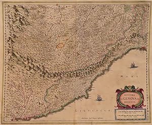
Riviera di Genova di Ponente
Edité par Joannem Jassonium, Amsterdam, 1638
Vendeur : William Chrisant & Sons, ABAA, ILAB. IOBA, ABA, Ephemera Society, Fort Lauderdale, FL, Etats-Unis
Membre d'association : ABAA ESA ILAB
Evaluation du vendeur :
Etat : Very Good. Seventeenth century map with original, hand-colored in outline of the Riviera from Genoa to Nice. Decorative cartouche. Latin text to verso with historiated initial. Please see image. Plate size approximately 20 1/2 x 17 1/2 in. Overall size approx. 21 3/4 x 18 in (550 x 460 mm).
-
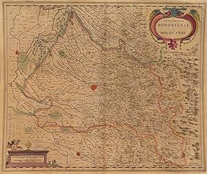
Territorium Bononiense il Bolognese
Edité par Johanne Janssonius c. 1640, Anmstedam, 1640
Vendeur : William Chrisant & Sons, ABAA, ILAB. IOBA, ABA, Ephemera Society, Fort Lauderdale, FL, Etats-Unis
Membre d'association : ABAA ESA ILAB
Evaluation du vendeur :
Etat : Very Good. Anmstedam: Johanne Janssonius. Very Good. c. 1640. 17th century map with original, hand-colored outlines of Bologna, Italy. Decorative cartouche. Latin text to verso with historiated initial. Please see image. Plate size approximately 21 1/4 x 17 in. Overall size approx. 21 x 18 in (545 x 450 mm).; All shipments through USPS insured Priority Mail. .
-
Descriptio Peregrinationis D. Pauli, Apostoli.
Edité par c. 1640, Amsterdam, 1640
Vendeur : Alexandre Antique Prints, Maps & Books, Toronto, ON, Canada
Membre d'association : ABAC ILAB
Evaluation du vendeur :

Carte
Etat : Very Good. Striking map of the Mediterranean and its surrounding areas. It depicts the travels of St. Paul. The decorative cartouche, presented in a curtain style design, follows the incidences St. Paul faced during his travels. Capsized ships are depicted in the map, one being attacked by a sea monster. , Size : 368x516 (mm), 14.50x20.30 (Inches), Hand Colored.
-
Ćgyptvs Antiqva Divifa in Nomos.
Edité par c. 1650, Amsterdam, 1650
Vendeur : Alexandre Antique Prints, Maps & Books, Toronto, ON, Canada
Membre d'association : ABAC ILAB
Evaluation du vendeur :
Carte
Etat : Very Good. Striking large scale map of Egypt with the course of the Nile. Depicted clearly are the boundaries of various local provinces. In Latin with a note in French. Includes a note in a decorative cartouche: \\\\\\\"A Monsieur Monsieur Doviat Sgr. de Montreuille, Con.er du Roy, et Maistre Ordinaire en sa Chambre des Comptes Par son Trčs humble et obéisant Serviteur P. Duval Géographe de sa Maiesté\\\"., Size : 394x521 (mm), 15.50x20.50 (Inches), Hand Colored.
-
Italia Gallica, Sive Gallia Cisalpina, Ex conatibus Geographicis Abrah. Ortelij.
Edité par c. 1662, Amsterdam, 1662
Vendeur : Alexandre Antique Prints, Maps & Books, Toronto, ON, Canada
Membre d'association : ABAC ILAB
Evaluation du vendeur :
Carte
Etat : Very Good. Striking detailed map of Southernh Italy. \"Cartouche on left hand side has 6 lines of placenames, while the cartouche on the bottom right corner has two columns of 12 people of uncertain location. This map is based on ancient knowledge from Livius, Ausonius, Tacitus, Cato, Plinius, Polybius and Cassiodore\\\\\\\". (Tooley, p. 258), Size : 349x465 (mm), 13.75x18.30 (Inches), Hand Colored.
-
Aeneae Troiani Navigatio Ad Virgilij sex priores Aeneidos
Edité par c. 1640, 1640
Vendeur : Alexandre Antique Prints, Maps & Books, Toronto, ON, Canada
Membre d'association : ABAC ILAB
Evaluation du vendeur :
Carte
Etat : Very Good. A map of the Mediterranean from Troy to Italy. Designed with two decorative cartouches, one of which includes a passage from the Roman epic The Aeneid, as well as a large inset map in the upper right corner. A group of capsized ships are depicted near Libya. , Size : 394x495 (mm), 15.50x19.50 (Inches), Hand Colored.
-
(Stolen)Imperium Romanum Auth Phil. Briet e Societ Iesu.
Edité par c. 1640, Amsterdam, 1640
Vendeur : Alexandre Antique Prints, Maps & Books, Toronto, ON, Canada
Membre d'association : ABAC ILAB
Evaluation du vendeur :
Carte
Etat : Very Good. (Stolen)Jansson's striking map of the Roman Empire. It was first issued based upon an earlier map of Briet, in the 1650s. The map includes an inset of the area around Rome., Size : 387x523 (mm), 15.25x20.60 (Inches), Hand Colored.
-
Vienna - Austriae. WIEN in Oostenreyk.
Edité par (1657):, 1657
Vendeur : Harteveld Rare Books Ltd., Fribourg, Suisse
Membre d'association : ILAB VEBUKU
Evaluation du vendeur :
39x50 cm (view) 41.5x52 cm (lichtmass) vue ŕ vol d?oiseau, coloriée ŕ la main d?époque, pli au milieu avec légčres traces, / fine handcolored view, light wear on middle fold, sous passepartout dans un cadre or. 56x65 cm (cadre) / framed. Please notify before visiting to see a book. Prices are excl. VAT/TVA (only Switzerland) & postage. Striking early view of Vienna from the east side of the Danube River, published by Jansson in 1657.Includes a key locating 42 points of interest on the map.The map is based upon the view of Vienna which appeared in Braun & Hogenberg'sCivitates Orbis Terrarum.
-
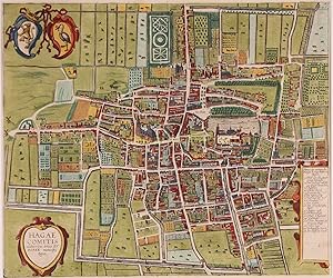
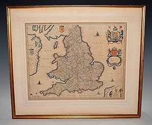
[MAP] PROVINCIA OXONIENSIS | OXFORD-SHIRE
Edité par Joannes Janssonius, Amsterdam, 1644
Vendeur : BLACK SWAN BOOKS, INC., ABAA, ILAB, Richmond, VA, Etats-Unis
Membre d'association : ABAA ESA ILAB
Evaluation du vendeur :
Etat : Very Good binding. A map of Oxfordshire, with text from the atlas in Dutch and Fraktur on the verso. The map is hand-colored, with a bar scale in "Milliaria Anglica" and "Milliaria Germanica communia" in the upper left corner, decorated with garlands and cherubs; the title cartouche is in the upper right, decorated with ribbons and the face of a man placed obscurely at the bottom. Originally a two-page print from Janssonius' Nievwen Atlas. Vol. III., the plates were latter purchased first by Peter Schenk and Gerard Valk, then by John and Henry Overton. Jansson's original plates were later embellished by Schenk with longitudinal and latitudinal lines, as well as small town plans; Overton added roads to his printings. This early Jansson edition contains none of the later embellishments. Housed in a black wooden frame in Very Good condition. The map is 38 x 49 cm. Very Good binding.
-
Creta Iovis magni, medio iacet insula ponto
Edité par c. 1640, Amsterdam, 1640
Vendeur : Alexandre Antique Prints, Maps & Books, Toronto, ON, Canada
Membre d'association : ABAC ILAB
Evaluation du vendeur :
Carte
Etat : Very Good. Striking map of Crete with decorative cartouche, ships and one sea monster scattered along the ocean. The map is based on the earlier work of Ortelius. , Size : 375x485 (mm), 14.75x19.10 (Inches), Hand Colored.
-
Cambriae Typus auctore Humfredo Lluydo Denbigiense Cambro britanno.
Edité par c.1640, Amsterdam, 1640
Vendeur : Alexandre Antique Prints, Maps & Books, Toronto, ON, Canada
Membre d'association : ABAC ILAB
Evaluation du vendeur :
Carte
Etat : Very Good. Decorated with a gathering of Puttos bearing fruit and charting the Planet\\\\\\\'s movements. A compass-rose stands alone to the left, with various ships and one sea monster placed along the ocean. , Size : 343x490 (mm), 13.50x19.30 (Inches), Hand Colored.
-
THE HAGUE AT THE BEGINNING OF THE 17TH CENTURY "HAGAE COMITIS celeberrimi totius EUROPAE municipij typus", copper enrgaving from the "Theatrum urbium Celebriorum totius Belgii sive Germaniae Inferioris," part II, published in Amsterdam by Jan Jansson (Johannes Janssonius) in 1657/58
Vendeur : Inter-Antiquariaat Mefferdt & De Jonge, Amsterdam, Pays-Bas
Membre d'association : ILAB NVVA
Evaluation du vendeur :
Art / Affiche / Gravure
THE HAGUE AT THE BEGINNING OF THE 17TH CENTURY "HAGAE COMITIS celeberrimi totius EUROPAE municipij typus", copper enrgaving from the "Theatrum urbium Celebriorum totius Belgii sive Germaniae Inferioris," part II, published in Amsterdam by Jan Jansson (Johannes Janssonius) in 1657/58. Coloured by a later hand. Size (print): 38.4 x 46.1 cm. There was a lot of construction in the first half of the 17th century because The Hague's population underwent expansive growth. In 1585, there were an estimated 7 to 8,000 inhabitants, barely more than in 1500. By 1600, that number had risen to 12,000, and by 1625, to 18,000. This was partly due to immigrants from the Southern Netherlands or rural people seeking a new life in the city. This map, for which the copperplate was made in 1616, is an accurate depiction of the city at the beginning of the 17th century. Government officials were found in the generously proportioned houses on Kneuterdijk, Voorhout, or Vijverberg, and also along main streets like Noordeinde. Independent tradespeople and merchants preferred to establish themselves along thoroughfares where they were clearly visible or along new harbours and canals. There, they could benefit from transportation facilities or passing traffic. Servants, soldiers, and night watchmen often lived in the rear, in alleys and gates behind the houses of the more affluent or in narrow side streets. The copper plate for this engraving was made for the townbook by Georg Braun and Franz Hogenberg. Forty years later, Jan Jansson used the same, by then outdated plate for his own townbook. By that time, the Singel canal had already been completed. An updated improved map had been brought to the market by Joan Blaeu in 1649. Price: Euro 1.250,-.
-
Pascaarte Van't Westlyckste Deel vande Middelandsche Zee.: Pascaarte Van't Oostelyckste Deel vande Middelandsche Zee.
Edité par c. 1650, Amsterdam, 1650
Vendeur : Alexandre Antique Prints, Maps & Books, Toronto, ON, Canada
Membre d'association : ABAC ILAB
Evaluation du vendeur :
Carte
A fine pair of mid-17th century see charts showing the Western and Eastern sides of the Mediterranean, by Jansson, depicting the Straits of Gibraltar in the West (on the first sheet) all the way to Syria and Palestine in the East (on the second sheet). The maps cover Spain, France, Corsica, Sardinia, Italy, Greece, Romania, Syria, Cyprus and parts of the Holy Land. The maps are from Jansson\\\'s Atlantis Majoris, the first commonly circulated sea atlas of the world published in the NetherlandsBoth maps include colourful and decorative cartouches; the Western map with a Nobleman and a bear chested Native holding up a cornucopia of fruit with a crown on top, the Eastern map with two Middle Eastern men dressed in layered garments,The measuring charts are housed in two dragon-like figures (Western) and ornamental frame (Eastern). Two fleur-de-lis compasses are also shown on each map. Latin text on verso.The sizes of the two maps are:418 x 540 (Eastern Sheet)418 x 532 (Western Sheet), Size : 418x540 (mm), 16.46x21.26 (Inches), Original Outline Coloring Occasional minor browning otherwise Very Good.
![Image du vendeur pour Namurcum Comitatus Auctore Iohann Surhonio [17th Century Map of Belgium] mis en vente par Sequitur Books](https://pictures.abebooks.com/inventory/md/md30051816971.jpg)


![Image du vendeur pour [MAP] PROVINCIA OXONIENSIS | OXFORD-SHIRE mis en vente par BLACK SWAN BOOKS, INC., ABAA, ILAB](https://pictures.abebooks.com/inventory/md/md22859248612.jpg)