
Montant total (1 article articles) :
Destination de la commande :

LA PEROUSE; BUFFON (4 résultats)
Passer aux résultats principaux de la recherche
Type d'article
- Tous les types d'articles
- Livres
- Magazines & Périodiques
- Bandes dessinées
- Partitions de musique
- Art, Affiches et Gravures
- Photographies
- Cartes (4)
-
Manuscrits &
Papiers anciens
Etat
- Tous
- Neuf
- Ancien ou d'occasion
Reliure
- Toutes
- Couverture rigide
- Couverture souple
Particularités
- Edition originale
- Signé
- Jaquette
- Avec images (1)
- Sans impression ŕ la demande
Pays
Evaluation du vendeur
-

[Atlantic Ocean map] Carte des Declinaisons et Inclinaisons de l'Aiguille Aimantee redigee d'apres la table des observations Magnetiques faites par les Voyageurs depuis l'Annee 1775
Edité par Paris, 1788
Vendeur : Alexandre Antique Prints, Maps & Books, Toronto, ON, Canada
Membre d'association : ABAC ILAB
Evaluation du vendeur :

Carte
This handsome sea chart that indicates magnetic needle readings along various routes through the Atlantic., Size : 850x532 (mm), 33.46x20.94 (Inches), Hand Colored in Outline Very Good; laid on acid-free paper for long-term preservation.
-
[Indian Ocean map] Carte des Declinaisons et inclinaisons de l'Aiguille Aimantee redigee d'apres la table des observations Magnetiques faites par les Voyageurs depuis l'Annee 1775.
Edité par Paris, 1788
Vendeur : Alexandre Antique Prints, Maps & Books, Toronto, ON, Canada
Membre d'association : ABAC ILAB
Evaluation du vendeur :
Carte
Etat : Very Good; An 18th century mapping of the Indian Ocean. This handsome sea chart depicts magnetic needle readings along various routes in the ocean from the Cape of Good Hope (le Cap des Aiguilles) to the South East Asian archipelago., Size : 511x583 (mm), 20.12x22.95 (Inches), Hand Colored in Outline.
-
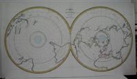
Carte Magnetique des Deux Hemispheres
Edité par Paris, 1788
Vendeur : Alexandre Antique Prints, Maps & Books, Toronto, ON, Canada
Membre d'association : ABAC ILAB
Evaluation du vendeur :
Carte
"Double hemispherical world map with each hemisphere shown on polar projection. Plate probably accompanied: Histoire naturelle, generale et particulare / George Louis Leclerc Buffon. Paris, 1749-1804. Plate "No. 8" of an 8 sheet map which was probably compiled from the reports of La Perouse?s last voyage in the Pacific and is by Jean-Charles Borda." (National Library of Australia Digital Collection map-rm3253), Size : 480x940 (mm), 18.875x37 (Inches), Hand Colored in Outline Very Good, folding map flattened and folds reinforced, laid on acid free canvas for long term preservation.
-
[North Pacific map] Carte des Declinaisons et inclinaisons de l'Aiguille Aimantee redigee d'apres la table des observations Magnetiques faites par les Voyageurs depuis l'Annee 1775.
Edité par Paris, 1788
Vendeur : Alexandre Antique Prints, Maps & Books, Toronto, ON, Canada
Membre d'association : ABAC ILAB
Evaluation du vendeur :
Carte
This handsome sea chart depicts magnetic needle readings along various routes in the North Pacific ocean., Size : 590x1090 (mm), 23.23x42.91 (Inches), Hand Colored in Outline Very Good; laid on acid-free canvas for long-term preservation.
