Montant total (1 article articles) :
Destination de la commande :

M LAVOISNE (43 résultats)
Passer aux résultats principaux de la recherche
Type d'article
- Tous les types d'articles
- Livres (40)
- Magazines & Périodiques
- Bandes dessinées
- Partitions de musique
- Art, Affiches et Gravures (2)
- Photographies
- Cartes (1)
-
Manuscrits &
Papiers anciens
Etat
- Tous
- Neuf
- Ancien ou d'occasion
Reliure
Particularités
- Edition originale (1)
- Signé (1)
- Jaquette
- Avec images (40)
- Sans impression ŕ la demande
Pays
Evaluation du vendeur
-
LA DENTELLE D'ARRAS-LECTURE FAITE A L'ACADEMIE D'ARRAS
Edité par Nouvelle société l'Avenir, Arras, 1931
Livre
Couverture souple. Etat : Bon. M.A. LAVOISNE, bibliothécaire-adjoint LA DENTELLE D'ARRAS-LECTURE FAITE A L'ACADEMIE D'ARRAS 1931, Arras, Edition Nouvelle société l'Avenir Format : In-12 (13,5 x 21,5 cm), broché, 9 pages Etat : papier propre, bon exemplaire poids : 50g.
-

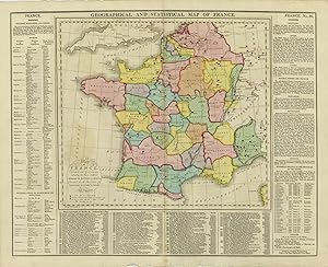
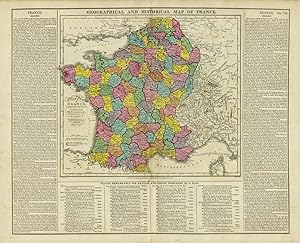
Geographical and Statistical Map of France
Date d'édition : 1820
Vendeur : Art Source International Inc., Boulder, CO, Etats-Unis
Evaluation du vendeur :

This beautiful map of France came from M. Lavoisnes Genealogical Historical Chronological and Geographical Atlas. Surrounding this colorful map is important textual information on geography, history, and major battles. ' This map measures 16.5 inches by 20.5 inches.
-

Chart of the World as Known to the Ancients and the Posterity of Noah
Date d'édition : 1820
Vendeur : Art Source International Inc., Boulder, CO, Etats-Unis
Evaluation du vendeur :
This unique map of the world as known to the Ancients on Mercators projection and the Posterity of Noah came from M. Lavoisne's Genealogical Historical Chronological and Geographical Atlas. These maps show the outline of ancient empires and contains explanatory text with important historical information. This map measures 16.5 inches by 20.25 inches.
-
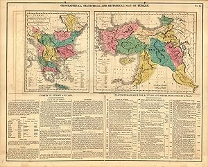
Geographical, Statistical and Historical Map of Turkey
Date d'édition : 1820
Vendeur : Art Source International Inc., Boulder, CO, Etats-Unis
Evaluation du vendeur :
This beautiful and historical map of Turkey came from M. Lavoisnes Genealogical Historical Chronological and Geographical Atlas. The maps detail Turkey in Europe and in Asia (including Greece, Hungary and the Balkan region, the Black Sea region, and much of the Middle East). Below the maps is important textual information on the geography, culture, and history of the area. This map is accompanied by 4 hand-colored sheets of genealogical and historical tables on the Empires of the Turks, Parthians, Constantinople, and the Kingdom of Persia. This map measures 16.5 inches by 20.25 inches.
-

GEOGRAPHICAL, STATISTICAL, AND HISTORICAL MAP OF ASIA . Published by
Edité par J. Barfield, London 1828, 1828
Carte
42x53cm in total (map: 32x32cm). The map in full original colour, surrounded by extensive descriptions of all Asian countries. Excellent condition. Shows the extent of the Empire of Jenghis Kah in 1226 and of Tamerlane in 1406.
-
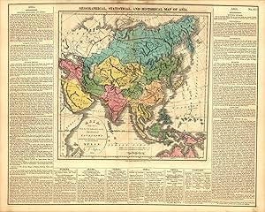
Geographical, Statistical and Historical Map of Asia
Date d'édition : 1820
Vendeur : Art Source International Inc., Boulder, CO, Etats-Unis
Evaluation du vendeur :
This beautiful map of Asia came from M. Lavoisnes Genealogical Historical Chronological and Geographical Atlas. Surrounding this colorful map are bodies of text with information on geography, history (with an emphasis on the Khan and Tamerlane empires), religion, language, etc. ' This map measures 16.5 inches by 20.5 inches.
-
Geographical and Statistical Map of France
Date d'édition : 1814
Vendeur : Art Source International Inc., Boulder, CO, Etats-Unis
Evaluation du vendeur :
Brightly-colored copper-plate map of France, surrounded by textual information regarding geography, history, political divisions, and battles. This is the oldest map by Lavoisne we have ever seen. This map measures 15.5 inches by 20 inches.
-
Geographical and Historical Map of France
Date d'édition : 1814
Vendeur : Art Source International Inc., Boulder, CO, Etats-Unis
Evaluation du vendeur :
Brightly-colored copper-plate map of France, surrounded by textual information regarding geography, history, political divisions, and battles. This is the oldest map by Lavoisne we have ever seen. This map measures 15.5 inches by 20 inches.
-
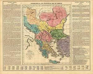
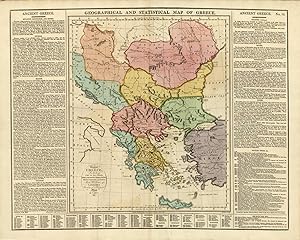
Geographical and Statistical Map of Greece
Date d'édition : 1820
Vendeur : Art Source International Inc., Boulder, CO, Etats-Unis
Evaluation du vendeur :
This beautiful and historical map of Greece came from M. Lavoisnes Genealogical Historical Chronological and Geographical Atlas. Significant battle sites are marked with red flags on the map. Surrounding this brightly colored map is important textual information on the geography and history of Greece. This map is accompanied by two pages of hand colored genealogical and historical tables. This map measures 16.75 inches by 20.75 inches.
-

Map of South America
Date d'édition : 1820
Vendeur : Art Source International Inc., Boulder, CO, Etats-Unis
Evaluation du vendeur :
This beautiful map of South America came from M. Lavoisnes Genealogical Historical Chronological and Geographical Atlas. Surrounding this brightly colored map is important textual information on geography and history. It is important to note that on this map, Chile is quite small, Patagonia is a separate country, and Argentina is La Plata or Buenos Ayres. This map measures 16.5 inches by 20.5 inches.
-
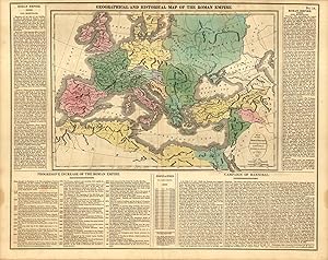
Geographical and Historical Map of the Roman Empire
Date d'édition : 1820
Vendeur : Art Source International Inc., Boulder, CO, Etats-Unis
Evaluation du vendeur :
This beautiful map of the Roman Empire came from M. Lavoisnes Genealogical Historical Chronological and Geographical Atlas. Surrounding this brightly colored map is important textual information on the structure and history of the Empire, and the Campaign of Hannibal. This map is accompanied by 3 hand-colored sheets of genealogical and historical tables. This map measures 16.5 inches by 20.5 inches.
-
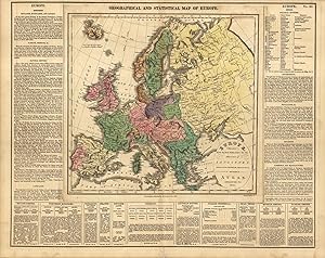
Geographical and Statistical Map of Europe
Date d'édition : 1820
Vendeur : Art Source International Inc., Boulder, CO, Etats-Unis
Evaluation du vendeur :
This beautiful map of Europe came from M. Lavoisnes Genealogical Historical Chronological and Geographical Atlas. Surrounding this brightly colored map is textual information on geography, history, and political divisions. This map measures 16.5 inches by 20.5 inches.
-
Geographical and Statistical Map of Greece
Date d'édition : 1814
Vendeur : Art Source International Inc., Boulder, CO, Etats-Unis
Evaluation du vendeur :
Brightly-colored copper-plate map of Greece, surrounded by textual information regarding geography, history, and political divisions. This is the oldest map by Lavoisne we have ever seen. This map measures 15.5 inches by 20 inches.
-
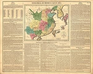
Geographical and Historical Map of China
Date d'édition : 1820
Vendeur : Art Source International Inc., Boulder, CO, Etats-Unis
Evaluation du vendeur :
This beautiful geographical and historical map of China and the "tributary kingdom of Corea" came from M. Lavoisnes Genealogical Historical Chronological and Geographical Atlas. Surrounding this brightly colored map are important geographical and historical information on China and the Empire of Japan. This map measures 16.5 inches by 20 inches.
-

Geographical and Historical Map of the Incursions of the Barbarians
Date d'édition : 1814
Vendeur : Art Source International Inc., Boulder, CO, Etats-Unis
Evaluation du vendeur :
Brightly-colored copper-plate map of the origins and movements of "barbarians" in Europe, surrounded by textual information regarding their location and history. This is the oldest map by Lavoisne we have ever seen. This map measures 15.5 inches by 20 inches.
-
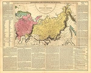
Geographical and Statistical Map of Russia
Date d'édition : 1820
Vendeur : Art Source International Inc., Boulder, CO, Etats-Unis
Evaluation du vendeur :
This beautiful map of Russia came from M. Lavoisnes Genealogical Historical Chronological and Geographical Atlas. Surrounding this brightly colored map is important textual information on geography, history, culture, and sites of significant battles. This map measures 16.5 inches by 20.5 inches.
-
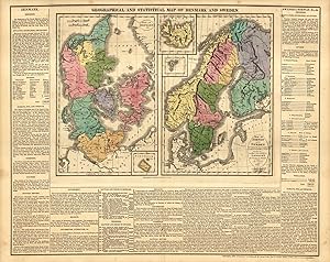
Geographical and Statistical Map of Denmark and Sweden
Date d'édition : 1820
Vendeur : Art Source International Inc., Boulder, CO, Etats-Unis
Evaluation du vendeur :
This beautiful map of Denmark and Sweden came from M. Lavoisnes Genealogical Historical Chronological and Geographical Atlas. This brightly colored copper-plate engraving has two maps, of Denmark and Finland (marked Russia), Sweden, and Norway. It also includes insets of Bornholm, Iceland, and the Faro Isles, and important geographical, historical, and political information surrounding the maps. ' This map measures 16.5 inches by 20.5 inches.
-
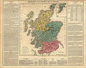
Geographical and Statistical Map of Scotland
Date d'édition : 1820
Vendeur : Art Source International Inc., Boulder, CO, Etats-Unis
Evaluation du vendeur :
This beautiful map of Scotland came from M. Lavoisnes Genealogical Historical Chronological and Geographical Atlas. The map details mountains, towns, major transportation routes, and islands, and includes an inset of the Shetlands. Surrounding this colorful map is important textual information on geography, history, and culture. This map also is accompanied by a page of hand-colored genealogical and historical tables. This map measures 16.5 inches by 20.5 inches.
-
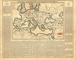
Geographical and Historical Map of the Incursions of the Barbarians
Date d'édition : 1820
Vendeur : Art Source International Inc., Boulder, CO, Etats-Unis
Evaluation du vendeur :
This historical map of the Incursions of the Barbarians came from M. Lavoisnes Genealogical Historical Chronological and Geographical Atlas. Surrounding this colorful map are bodies of text with important historical information. ' This map measures 16.5 inches by 20.25 inches.
-

Geographical and Historical Maps, Illustrative of Sacred History
Date d'édition : 1829
Vendeur : Art Source International Inc., Boulder, CO, Etats-Unis
Evaluation du vendeur :
This highly unique map was made by C. V. Lavoisne and published by John Satchell in London 1829. This map was originally published in "Lavoisnes Complete Genealogical, Historical, Chronological, and Geographical Atlas." Special to these maps is the fascinating description surrounding the map, which discusses the land of Canaan and the conquests of the Israelites. A wonderful map, full of history! This map is accompanied by pages of hand colored genealogical and historical tables. This map measures 16.5 inches by 20.5.
-
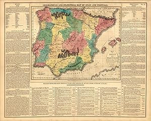
Geographical and Statistical Map of Spain and Portugal
Date d'édition : 1820
Vendeur : Art Source International Inc., Boulder, CO, Etats-Unis
Evaluation du vendeur :
This beautiful map of Spain and Portugal came from M. Lavoisnes Genealogical Historical Chronological and Geographical Atlas. The map details mountain ranges and battle sites, and is surrounded by important textual information on the geography and history of the region. ' This map measures 16.5 inches by 20.5 inches.
-
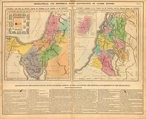
Geographical and Historical Maps, Illustrative of Sacred History
Date d'édition : 1820
Vendeur : Art Source International Inc., Boulder, CO, Etats-Unis
Evaluation du vendeur :
This beautiful map, illustrative of Sacred History, came from M. Lavoisnes Genealogical Historical Chronological and Geographical Atlas. The two maps show "Canaan, with Part of Egypt, during the Residence of the Israelites in the Desert" and "Canaan, subsequent to its Conquest by the Israelites, and its Division among the Tribes". Below the maps contain important historical information. This map is accompanied by 3 pages of hand-colored historical tables. This map measures 16.5 inches by 20.5 inches.
-
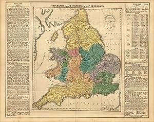
Geographical and Statistical Map of England
Date d'édition : 1820
Vendeur : Art Source International Inc., Boulder, CO, Etats-Unis
Evaluation du vendeur :
This beautiful map of England came from M. Lavoisnes Genealogical Historical Chronological and Geographical Atlas. Surrounding this brightly colored map is textual information on geography, history, political divisions, and even a paragraph on "national character". Major transportation routes and cities are also shown. ' This map measures 17 inches by 21 inches.
-
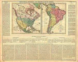
Geographical, Historical and Statistical Map of America
Date d'édition : 1820
Vendeur : Art Source International Inc., Boulder, CO, Etats-Unis
Evaluation du vendeur :
This beautiful map of the Americas came from M. Lavoisnes Genealogical Historical Chronological and Geographical Atlas. The map shows North and South America side by side. It also shows Northern Mexico, California, and Texas all as part of "Internal Provinces", and the routes of Cortez, Columbus, and Pizarro. Surrounding the maps are bodies of text with important historical and geographical information. ' This map measures 16.5 inches by 20.5 inches.
-
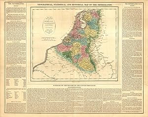
Geographical, Statistical and Historical Map of the Netherlands
Date d'édition : 1820
Vendeur : Art Source International Inc., Boulder, CO, Etats-Unis
Evaluation du vendeur :
This beautiful map of the Netherlands came from M. Lavoisnes Genealogical Historical Chronological and Geographical Atlas. Surrounding this brightly colored map is important textual information on geography, history, and political divisions. This map measures 16.5 inches by 20.5 inches.
-

Geographical and Statistical Map of Poland and Hungary
Date d'édition : 1820
Vendeur : Art Source International Inc., Boulder, CO, Etats-Unis
Evaluation du vendeur :
This beautiful map of Poland and Hungary came from M. Lavoisnes Genealogical Historical Chronological and Geographical Atlas. Surrounding this colorful map is important text containing geographical and historical information. This map is also accompanied by a hand colored sheet of genealogical tables of dukes and kings of Poland. ' This map measures 16.5 inches by 20 inches.
-
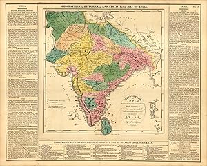
Geographical, Historical and Statistical Map of India
Date d'édition : 1820
Vendeur : Art Source International Inc., Boulder, CO, Etats-Unis
Evaluation du vendeur :
This beautiful and historical map of India came from M. Lavoisnes Genealogical Historical Chronological and Geographical Atlas. Surrounding this brightly colored map is important textual information on geography, history, British possessions, sites of battles or sieges, and includes notes such as "High Mountains of hard Rock" and "Great Desert subject to burning winds". ' This map measures 16.5 inches by 20.5 inches.
-
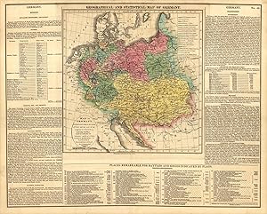
Geographical and Statistical Map of Germany
Date d'édition : 1820
Vendeur : Art Source International Inc., Boulder, CO, Etats-Unis
Evaluation du vendeur :
This beautiful and historical map of Germany (including Poland and the Austrian Empire) came from M. Lavoisnes Genealogical Historical Chronological and Geographical Atlas. Surrounding this colorful map is important textual information on the geography, government, and history of Germany. The map is accompanied by 3 more hand-colored informational sheets giving genealogical & historical information. ' This map measures 16.5 inches by 20.75 inches.
-
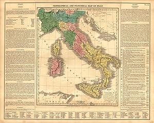
Geographical and Statistical Map of Italy
Date d'édition : 1820
Vendeur : Art Source International Inc., Boulder, CO, Etats-Unis
Evaluation du vendeur :
This beautiful map of Italy came from M. Lavoisnes Genealogical Historical Chronological and Geographical Atlas. Surrounding this brightly colored map is textual information on geography, history, and political divisions. This map is accompanied by a hand colored sheet of genealogical and historical tables. This map measures 16.5 inches by 20.5 inches.
-
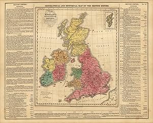
Geographical and Historical Map of the British Empire
Date d'édition : 1820
Vendeur : Art Source International Inc., Boulder, CO, Etats-Unis
Evaluation du vendeur :
This beautiful and historical map of the British Empire came from M. Lavoisne's Genealogical Historical Chronological and Geographical Atlas. The maps detail England, Ireland, and Scotland. Besides the maps is important textual information on the geography, culture, and history of the area. This map measures 16.5 inches by 20.25 inches.