
Montant total (1 article articles) :
Destination de la commande :

MERCATOR, GERARD HONDIUS, JOCODUS (4 résultats)
Passer aux résultats principaux de la recherche
Type d'article
- Tous les types d'articles
- Livres
- Magazines & Périodiques
- Bandes dessinées
- Partitions de musique
- Art, Affiches et Gravures
- Photographies
- Cartes (4)
-
Manuscrits &
Papiers anciens
Etat
- Tous
- Neuf
- Ancien ou d'occasion
Reliure
- Toutes
- Couverture rigide
- Couverture souple
Particularités
- Edition originale
- Signé
- Jaquette
- Avec images (2)
- Sans impression ŕ la demande
Pays
Evaluation du vendeur
-

I.S. Margareta cum Confiniis
Edité par Amsterdam, 1611
Vendeur : Alexandre Antique Prints, Maps & Books, Toronto, ON, Canada
Membre d'association : ABAC ILAB
Evaluation du vendeur :

Carte
Etat : Very Good. This is the I.S. Margareta section of the famous composite map of five West Indian islands from the Mercator/ Hondius Atlas, first published in 1606., Size : 105x110 (mm), 4.125x4.375 (Inches), Original Hand Coloring.
-
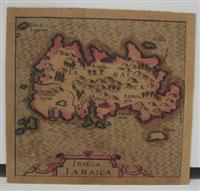
Insula Iamaica
Edité par Amsterdam, 1611
Vendeur : Alexandre Antique Prints, Maps & Books, Toronto, ON, Canada
Membre d'association : ABAC ILAB
Evaluation du vendeur :
Carte
Etat : Very Good. This is the Jamaica section from the famous composite map of five West Indian islands from the Mercator/ Hondius Atlas, first published in 1606., Size : 105x112 (mm), 4.125x4.375 (Inches), Original Hand Coloring.
-
Livonia
Edité par Amsterdam, 1621
Vendeur : Alexandre Antique Prints, Maps & Books, Toronto, ON, Canada
Membre d'association : ABAC ILAB
Evaluation du vendeur :
Carte
Etat : Very Good. Size : 145x190 (mm), 5.75x7.5 (Inches), Hand Colored.
-
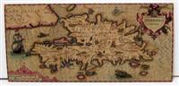
Hispaniola Insula
Edité par Amsterdam, 1606
Vendeur : Alexandre Antique Prints, Maps & Books, Toronto, ON, Canada
Membre d'association : ABAC ILAB
Evaluation du vendeur :
Carte
The Hispaniola (Haiti and Dominican Republic) section of the the famous composite map of five West Indian islands from the Mercator/ Hondius Atlas, first published in 1606., Size : 170x360 (mm), 6.75x14.125 (Inches), Original Hand Coloring Very Good; laid down on acid-free canvas for long term preservation; margins shaved along border of the map.
