Montant total (1 article articles) :
Destination de la commande :

MICHEL ETIENNE TURGOT (13 résultats)
Passer aux résultats principaux de la recherche
Type d'article
- Tous les types d'articles
- Livres (11)
- Magazines & Périodiques
- Bandes dessinées
- Partitions de musique
- Art, Affiches et Gravures
- Photographies
- Cartes (2)
-
Manuscrits &
Papiers anciens
Etat
Reliure
Particularités
Pays
Evaluation du vendeur
-

Gouverneurs Lieutenans de Roy Prevôts Des Marchands Echevins Procureurs Avocats Du Roy Greffiers: Receveurs Conseillers Et Quartiniers de la Ville de . Gravées Par Beaumont Graveur (French Edition)
Edité par Hachette Livre Bnf, 2020
ISBN 10 : 2329407262ISBN 13 : 9782329407265
Livre
Etat : New.
Plus de choix d'achat de la part d'autres vendeurs sur AbeBooks
Offres neuf ŕ partir de EUR 25,71
-
![Image du vendeur pour Paris au XVIIIe sičcle; plan de Paris en 20 planches. Dessiné et gravé sous les ordres [LeatherBound] mis en vente par True World of Books](https://pictures.abebooks.com/inventory/md/md31533632702.jpg)
Paris au XVIIIe sičcle; plan de Paris en 20 planches. Dessiné et gravé sous les ordres [LeatherBound]
Date d'édition : 2023
Livre impression ŕ la demande
LeatherBound. Etat : New. Leather Binding on Spine and Corners with Golden leaf printing on spine. Bound in genuine leather with Satin ribbon page markers and Spine with raised gilt bands. A perfect gift for your loved ones. Reprinted from 1908 edition. NO changes have been made to the original text. This is NOT a retyped or an ocr'd reprint. Illustrations, Index, if any, are included in black and white. Each page is checked manually before printing. As this print on demand book is reprinted from a very old book, there could be some missing or flawed pages, but we always try to make the book as complete as possible. Fold-outs, if any, are not part of the book. If the original book was published in multiple volumes then this reprint is of only one volume, not the whole set and contains approximately 24 pages. IF YOU WISH TO ORDER PARTICULAR VOLUME OR ALL THE VOLUMES YOU CAN CONTACT US. Resized as per current standards. Sewing binding for longer life, where the book block is actually sewn (smythe sewn/section sewn) with thread before binding which results in a more durable type of binding. Language: French.
-
![Image du vendeur pour Catalogue des livres de la bibliotheque de M. *** dont la vente se fera a l'amiable le [blank] janvier 1744 dans une des salles du couvent des RR. PP. Augustins 1744 [LeatherBound] mis en vente par True World of Books](https://pictures.abebooks.com/inventory/md/md31617586791.jpg)
Catalogue des livres de la bibliotheque de M. *** dont la vente se fera a l'amiable le [blank] janvier 1744 dans une des salles du couvent des RR. PP. Augustins 1744 [LeatherBound]
Date d'édition : 2023
Livre impression ŕ la demande
LeatherBound. Etat : New. LeatherBound edition. Condition: New. Reprinted from edition. Leather Binding on Spine and Corners with Golden leaf printing on spine. Bound in genuine leather with Satin ribbon page markers and Spine with raised gilt bands. A perfect gift for your loved ones. NO changes have been made to the original text. This is NOT a retyped or an ocr'd reprint. Illustrations, Index, if any, are included in black and white. Each page is checked manually before printing. As this print on demand book is reprinted from a very old book, there could be some missing or flawed pages, but we always try to make the book as complete as possible. Fold-outs, if any, are not part of the book. If the original book was published in multiple volumes then this reprint is of only one volume, not the whole set. Sewing binding for longer life, where the book block is actually sewn (smythe sewn/section sewn) with thread before binding which results in a more durable type of binding. Pages: 539.
-

Le Plan de Paris de Louis Bretez dit Plan de Turgot. Edition du Jubile 1739-1989. Presente et commente par Bernard Rouleau.
Edité par Nördlingen: Uhl 1989., 1989
Vendeur : Antiquariat Bergische Bücherstube Mewes, Overath, Allemagne
Membre d'association : GIAQ ILAB VDA
Evaluation du vendeur :

16 Seiten, ein Übersichtsplan und 20 doppelseitige Tafeln, 42,5 x 54 cm, Kunstleder. Die grossformatigen Tafeln dieses Plans können zu einem Vogelschaubild von 245 x 326 cm zusammengesetzt werden. Bretez hat die Stadt Strasse für Strasse vermessen und jedes Haus in die kunstvoll gestaltete Karte uebertragen. Diese zeigt die Metropole in ihrem fast noch mittelalterlichen Zustand mit dichten Häuserhaufen, alten Kirchen, gepflegten Hofgärten und Stadtresidenzen, aber noch ohne die Boulevards, die prächtigen Stadtplätze und die dominierenden Prachtbauten der franzoesischen Klassik. Als Ludwig XIV. 1649 die Residenz nach Versailles verlegt hatte, blieben die wenige Jahre zuvor begonnenen Um- und Neubauten am Louvre rund hundert Jahre lang schutzlos und ohne Daecher liegen. Die insgesamt zwanzig Tafeln zeigen in nicht überlappenden isometrischen Darstellungen die französische Hauptstadt in der Sicht von Südwesten. Der Plan Turgot hat den Maßstab von ca. 1:400. In originalgetreuer Wiedergabe sind die Gebäude, die Straßen und Plätze sowie die Gärten und Parkanlagen der Stadt zu sehen. Jede Tafel besteht aus einem rechteckigen Bild von 50 cm Höhe und 80 Zentimeter Breite, das im Atlas in der Mitte gefaltet ist. Der Atlas umfasst das Gebiet der heutigen ersten 11 Arrondissements von Paris.
-
Plan de Paris
Edité par Paris, Paris, 1739
Vendeur : High Ridge Books, Inc. - ABAA, South Deerfield, MA, Etats-Unis
Membre d'association : ABAA ESA ILAB SNEAB
Evaluation du vendeur :
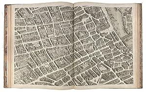
20 double-page beautifully engraved maps,joined to together making up a huge map of Paris. Considerable restorations with some facsimile work. While not pristine, this is nonethless a very good example of this scarce map, by far the finest map of Paris of its day. The detail of this plan, which shows every building in Paris, was an example for many other city plans over the next 150 years.
-
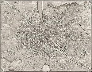
Plan de Paris commencé l'année 1734
Date d'édition : 1739
Edition originale
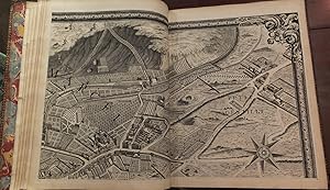
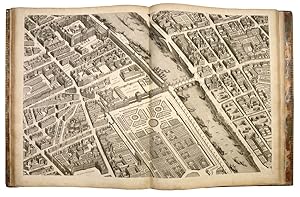
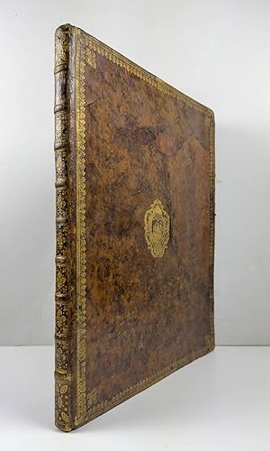
Couverture rigide. Etat : Bon. Edition originale. Folio. Reliure contemporaine en veau aux armes de la ville de Paris. Reliure usée. Exemplaire sur grand papier. Premier tirage du plan dit de Turgot, levé et dessiné par Louis Bretez, gravé par Claude Lucas graveur de l'Académie Royale des Sciences, et écrit par Aubin. Il se compose d'un plan d'assemblage au trait, et de 20 superbes planches doubles gravées en taille-douce, montées sur onglets. Titre gravé dans un grand cartouche en bas des planches 18 et 19 réunies en une seule planche dépliante. Encadrement du plan avec une fleur de lys aux 4 angles Plan en "perspective cavaličre". Le plan de Bretez correspond aux objectifs de Turgot : il ne s'agit pas lŕ d'un plan scientifique, mais d'une représentation théâtrale de la ville de Paris afin d'en promouvoir son image. C'est une opération de propagande, ŕ la gloire de la ville capitale du royaume et du prévôt des marchands qui vient encore d'en accroître ŕ la fois l'étendue et l'éclat. Jean Boutier, Les plans de Paris, 219 // ENGLISH // Folio. Contemporary calf with the arms of the city of Paris. Binding damaged. Copy on large paper. First edition of the so-called Turgot plan. First edition of the so-called Turgot plan, surveyed and drawn by Louis Bretez, engraved by the engraver of the Royal Academy of Sciences Claude Lucas, and written by Aubin. It consists of an overview map showing the layout of the sectional maps, and 20 bird's-eye view maps copper-engraved on double-page, all mounted on tabs. Title engraved in a large decorated cartouche surmounted by an allegory of the City of Paris and located at the bottom of plates 18 and 19. Framing of the plan with a fleur-de-lys at the 4 corners.The Turgot map of Paris is a highly accurate and detailed map of the city, made in isometric perspective. Bretez's plan matches Turgot's objective: a true propaganda operation aimed at the elites (Parisian, provincial and foreign) to promote the image of Paris. The plan of Paris that Turgot had drawn up was not intended to be scientific, geometrical or mathematical, nor of the latest topographical modernity; it had to be theatrical, immense, it had to please, and it had to impress. It must promote the magnificence of Paris, its spaces, its balance, its beauty.Jean Boutier, Les plans de Paris, 219.
-
Plan de Paris. Commence L?Annee 1734, dessine et grave sous les ordres de Messire Michel Turgot? / Leve et dessine par Louis Bretez / Grave par Claude Lucas / Et ecrit par Aubin.
Edité par Michel Turgot c. 1739, Paris, 1739
Vendeur : Alexandre Antique Prints, Maps & Books, Toronto, ON, Canada
Membre d'association : ABAC ILAB
Evaluation du vendeur :

Edition originale
Edition : First Edition. , recent red full morocco with the coats of arms of Paris. , This is the most beautiful and celebrated plan of the city of Paris. Turgot?s maps were designed and engraved with scroll borders to the extreme edges, so that the entire twenty plates could be assembled to form one complete map of Paris (8 ˝ x 10 ˝ feet). Each arrondissement is shown from a birds-eye view; not only are the streets named and portrayed in detail, but all of the houses, hotels, churches, monuments, private gardens and city parks are delineated in panoramic perspective such that the architectural ornamentation of the buildings can be identified., Size : Tall folio (560 x 455 mm), Complete with 20 double-page engraved panoramic maps, and double-page index plan., References : Berlin Katalog 2506; Boutier 219, P. 21 double-page plates. A fine copy, plates are generally very clean and crisp, and the atlas is in superb period binding.
-
Plan de Paris, commence l'annee 1734. Acheve de Graveur en 1739
Edité par [Paris: 1739 or 1740]., 1740
Vendeur : Arader Galleries - AraderNYC, New York, NY, Etats-Unis
Evaluation du vendeur :
Folio (22 x 17 4/8 inches). Fine folding engraved key map, and 20 double-page engraved sheets that combine to make one exceptionally large plan of Paris (ca 98 inches x 127 inches) by Claude Lucas after Louis Bretez (sheets 18 and 19, with the title cartouche, joined and folding) (a bit browned throughout). Contemporary red morocco gilt, each cover decorated with broad gilt borders of fleur-de-lis and palm frond roll tools, with large fleur-de-lis at each inner corner, and with a fine central gilt medallion of the arms of the city of Paris, the spine in ten compartments with nine raised bands, red morocco lettering-piece in one, the others decorated with fine gilt tools, all edges gilt (rebacked preserving most of the original spine, some restoration to corners). Provenance: with the ownership inscription of "Pen: Wyndham" (Henry Penruddocke Wyndham, (1736 1819)), topographer on the verso of the front free endpaper. A MAGNIFICENT AND DETAILED PLAN OF PARIS: AN ISOMETRIC PERSPECTIVE FROM THE SOUTHEAST COMPOSED OF 20 SEPARATE ENGRAVED SHEETS. The area covered by this extraordinary map includes roughly the first eleven arrondissements of modern Paris, and is a fine and beautiful representation of the capital before the transformation made to the city by Napoleon III and Haussmann. At the time of this survey France, and so Paris, was effectively being ruled, with King Louis XV s assent, by Cardinal de Fleury. From 1726 until Fleury s death in 1743 was the most peaceful and prosperous part of the reign of Louis XV. After the financial turmoil and human suffering at the end of the reign of Louis XIV, the rule of Fleury is seen by many historians as a period of recovery. He stabilized the French currency, balanced the budget, and made economic expansion a central goal of the government. Communications were improved with the completion of the Saint-Quentin canal (linking the Oise and Somme rivers) in 1738, later extended to the Escaut River and the Low Countries and the systematic building of a national road network. By the middle of the 18th century, France had the most modern and extensive road network in the world. In this map, avenues, streets, and individual buildings, gardens, lumber and boatyards are all shown with exquisite accuracy, as the official surveyor, Louis Bretez, was given carte blanche to enter private property to record the finest details between 1734 and 1736. He was commissioned by Turgot, as the then head of the Paris municipality, to create this stunning image of Paris, to promote to the great and the good at home and abroad. Bretez, was a member of the Academy of Painting and Sculpture and a teacher of perspective. Claude Lucas, a member of the Academy of Sciences, engraved the plates in 1836. In 1739 the prints were bound in volumes presented to the King, members of the Academy, the Municipality, and French envoys abroad, to promote the beauty and magnificence of Paris. From the distinguished library of Pen Wyndham, who as a young man travelled extensively in Europe: "with his relation Joseph Wyndham, and William Benson Earle of Salisbury, Wyndham set out on the grand tour in 1765. Theirs was not the usual party of very young men with a tutor. Pen Wyndham was by this time twenty-nine and had already demonstrated some learning as an antiquary. After leaving England in September, the party visited France, Italy, and Sicily, and returned via Geneva and the Netherlands to reach England in September 1767. Pen Wyndham's letters to his father (now in the Wiltshire and Swindon Record Office, Trowbridge) show him very critical of much of what he saw. As well as the normal litany of complaints about the inns, food, and predations of the local people, he showed the family whig traits by complaining about the despotic rulers of the lands he passed through, and compared the poverty and ignorance of their people with the happy freedoms of the British. He enjoyed seeing John Wilkes at Dijon and was in Rome at the time of.
-
Plan de Paris, Commencé l'Année 1734. Dessiné et Gravé, sous les ordres de Messire Michel Etienne Turgot . Achevé de Graver en 1739 .
Edité par Paris, 1739
Vendeur : Donald A. Heald Rare Books (ABAA), New York, NY, Etats-Unis
Membre d'association : ABAA ILAB
Evaluation du vendeur :
Edition originale
Folio. (21 5/8 x 17 1/2 inches). Folding index map and very large perspective plan on 20 sheets by Claude Lucas after Louis Bretez, sheets 18 and 19 joined as issued, decorative engraved border with fleur-de-lys cornerpieces, title in elaborate figural cartouche. Contemporary calf, Boards with gilt, borders fleur-de-lys at corners, gilt Arms of Paris on front board, spine gilt in compartments, gilt edges, red morocco labels, marble endpapers. A First Copy of the First edition of the monumental Turgot plan of Paris: a cartographical tour-de-force. The best 18th-century plan of Paris, and among the most impressive of all city plans. The 20 sheets of this impressive atlas form a single enormous plan, which when joined would be approximately 8.25 x 10.5 feet. The map covers an area approximately corresponding to the first eleven of the modern-day arrondissements and is the best 18th century plan of Paris. In 1734, Michel-Étienne Turgot, chief of the municipality of Paris, in order to promote the reputation of Paris commissioned a new map of the city. He asked Louis Bretez, member of the Royal Academy of Painting and Sculpture and professor of perspective, to draw up the plan of Paris and its suburbs. As Turgot requested a very faithful map with great accuracy, for two years Bretez was allowed to enter into the mansions, houses and gardens of the city in order to take precise measurements. In the eighteenth century, the trend was to abandon the Renaissance-style portraits of cities for geometric plans, as technically and mathematically superior. The Turgot plan, however, on an isometric projection oriented toward the southeast, uses a system of perspective cavaliere: two buildings of the same size are represented by two drawings of the same size, whether the buildings are close or distant. The effect is a mesmerizing bird's eye view which shows the city in all its magnificence. Claude Lucas, engraver of the Royal Academy of Sciences, masterfully engraved the plan, which was published between 1739 and 1740. The map was bound in elegant volumes and offered to the King, the members of the Academy, the Municipality, and important visiting dignitaries. Brunet I:1224; Cohen de Ricci 803; Boutier, Les Plans de Paris des origines, BNF, 2002, 219; Millard, French 39; Berlin Katalog, 2506; Pinon 61.
-
Plan de Paris.
Edité par Paris Achevé de gravure, 1739
Vendeur : Shapero Rare Books, London, Royaume-Uni
Membre d'association : ABA ILAB PBFA
Evaluation du vendeur :

Carte
Folio (56.4 x 45.4 cm). Folding overview map, 20 double-page maps engraved by Claude Lucas after Bretez including 1-16 numbered in the plate, plates 18 and 19 joined and folded. Contemporary red morocco gilt, covers with gilt borders, gilt arms of Paris to covers, fleur-de-lys to corners, spine in ten compartments, gilt lettered direct in second, others with fleur-de-lys tooling, raised bands, a very attractive example. Turgot's celebrated plan of Paris during the reign of Louis XV - a fine, fresh copy attractively bound in full morocco. Michel-Etienne Turgot (1690-1751), Louis XV's Prévot des Marchands, commissioned this plan in 1734 from Louis Bretez, a sculptor, painter and perspective specialist, who used the conventional bird's-eye representation (isometric projection). The stunning result shows maps with great and decorative details, being an important record of the architecture and gardens of Baroque Paris, the world capital at the time. This was the last major example of this type of plan. Michel-Etienne Turgot was chief of the municipality of Paris as provost of merchants (the equivalent of today's mayor). He is the father of the famous economist and statesman Anne-Robert-Jacques Turgot, which history has remembered as an early advocate for economic liberalism. What motivated Michel-Etienne Turgot to commission a map of Paris was his will to promulgate the reputation of the city for Parisian, provincial or foreign elites. That is why he asked Louis Bretez (c. 16. - Paris, 1736), a French architect, cartographer and professor of perspective who belonged to the Royal Academy of Painting and Sculpture, to draw up the plan of Paris and its suburbs. Over his two years of work (1734-1736), Bretez was granted access to all the houses and gardens he needed to visit in order to take the relevant measurements. The 21 sheets of the plan were created in 1736 by Claude Lucas, engraver of the Royal Academy of Sciences. The plan was published in 1739, and the prints were bound in volumes offered to the King, the members of the Academy and the Municipality. Additional copies were kept to be used as representations of France to foreigners. The 21 engraved brass plates are held by the Chalcography of the Louvre, where they are still used for re-printing based on the same techniques as almost three centuries ago. Millard 39.
-
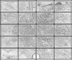
Plan de Paris. Commencé l'Année 1734. Dessiné et Gravé sous les ordres de. Achevé de Graver en 1739. Levé et Dessiné par Louis Bretez , Gravé par Claude Lucas et Ecrit par Aubin.
Edité par Paris -39, 1734
Vendeur : Robert Frew Ltd. ABA ILAB, London, Royaume-Uni
Membre d'association : ABA ILAB PBFA
Evaluation du vendeur :
Carte Edition originale
FIRST EDITION. 20 original engraved double page sheets (each c. 52 x 80 cm) here presented as 20 framed panels each measuring c. 56 x 85 cm giving a total wall space of 280 x 340 cm. A fascinating and colossal view of Paris and amongst the greatest city views of all time. Michel-Etienne Turgot (1690-1751), Louis XV's Prévot des Marchands, commissioned this plan in 1734 from Louis Bretez, a sculptor, painter and perspective specialist, who used the conventional bird's-eye representation isometric projection. The stunning result shows maps with great and decorative detail, being an important record of the architecture and gardens of Baroque Paris, the world capital at the time. This was the last major example of this type of plan. Michel-Etienne Turgot was chief of the municipality of Paris as provost of merchants the equivalent of today's mayor. He was the father of the famous economist and statesman Anne-Robert-Jacques Turgot, whom history remembers chiefly as an early advocate for economic liberalism. Turgot was motivated to commission a map of Paris by his will to champion the reputation of the city for Parisian, provincial or foreign elites. As such he asked Louis Bretez, a French architect, cartographer and professor of perspective (who belonged to the Royal Academy of Painting and Sculpture), to draw up the plan of Paris and its suburbs. Over his two years of work 1734-1736, Bretez was granted access to all the houses and gardens he needed to visit in order to take the relevant measurements.
-
Plan de Paris Commencé l'Année 1734. Dessiné et Gravé, sous les ordres de Messire Michel Etienne Turgot, Marquis de Sousmons Seigneur de S.t Germain sur Eaulne, Vatierfille, et autres Lieux, Conseiller d'Etat, Prevôt des March.ds. Achevé de Graver en 1739
Edité par Paris, 1739
Edition originale
Hardcover. Etat : Very good. First. A VAST MAP OF A VANISHED PARIS. [Paris?: no publisher, 1739-1740]. First edition. Folio (21 5/8" x 17 5/16", 550mm x 439mm): with 21 engraved double-page plates: a key map and 20 sectional maps (with sections 18 and 19, splitting the cartouche, already joined and folding). Bound in contemporary (publisher's?) mottled calf, with the arms of Paris gilt to the center of each board. Gilt border (fleur-de-lys alternating with palmettes within several rolls) to both boards, with fleur-de-lys corner-pieces. On the spine, nine raise bands, with fleurs-de-lys gilt to each panel. Title gilt to red morocco in the second panel. Gilt roll to the edges of the boards, carrying over into the inside dentelle. Marbled end-papers. All edges of the text-block gilt. Tail restored, with modern tooling. Restored patch to the front board. Some darkening and cracking to the borders and edges of the boards, and scuffing to the spine. Occasional soiling or small closed edge-tears. Altogether very good. Michel-Étienne Turgot (1690-1751), Marquess of Sousmont and the de facto mayor of Paris -- Prévôt des marchands or merchants' provost -- from 1729 to 1740 is best remembered for his commissioning of a plan of the city unlike any that preceded it. Its scale -- over 8' tall and 10' wide -- and precision (rendered at a scale of ca. 1:400) are almost incalculable. Turgot commissioned Louis Bretez (â 1737) to resurvey the city, giving him leave to enter structures and estates to carry out detailed measurements and drawings -- a task that took fully two years. This was a project of civil pride rather than necessity, and so of course it gained a great many supporters and sponsors at a great rate, whose names appear in the cartouche after Turgot's: Henry Millon, Exquier Con.er du Roi, Quartinier, Philippes le Fort, Ex.er Jean Claude Fauconnet de Vildé, Ec.er Con.er du Roi, et de la Ville, Acovat en la Cour Expéditionnaire de Cour de Rome; Claude Augustin Josset, Ex.er Con.er du Roi Acovat en la Cour Expédit.re de Cour de Rome; Echevins de la Ville de Paris Antoine Moriau, Ec.er Procureur et Avocat du Roi, et de la Ville, Jean Baptiste Julien Taitbout, Chevalier de l'Ordre du Roi, Greffier en Chef, Jacques Boucot, Chevalier de l'Ordre du Roi, Receveur. With such endorsements and access, Bretez and his engraver Claude Lucas have created an intimate portrait of a vanished city; the destruction of the Revolution and the rebuilding of Hausmann under Napoleon III would fundamentally reshape the City of Light. Brunet I.1224 ([24144]; sub Bretez); Cohen-de Ricci I.807.