Montant total (1 article articles) :
Destination de la commande :

PIERRE VANDER AA (57 résultats)
Passer aux résultats principaux de la recherche
Type d'article
- Tous les types d'articles
- Livres (12)
- Magazines & Périodiques
- Bandes dessinées
- Partitions de musique
- Art, Affiches et Gravures
- Photographies
- Cartes (45)
-
Manuscrits &
Papiers anciens
Etat
- Tous
- Neuf
- Ancien ou d'occasion
Reliure
- Toutes
- Couverture rigide
- Couverture souple
Particularités
- Edition originale (1)
- Signé
- Jaquette (1)
- Avec images (12)
- Sans impression ŕ la demande
Pays
Evaluation du vendeur
-

L'Alsace. Suivant les Nouvelles Observations de Mess.rs de l'Academie Royale des Sciences, etc. Augmentees de Nouveau
Edité par Pierre Vander Aa c.1713, Leiden, 1713
Vendeur : Alexandre Antique Prints, Maps & Books, Toronto, ON, Canada
Membre d'association : ABAC ILAB
Evaluation du vendeur :

Carte
Size : 271x398 (mm), 10.67x15.67 (Inches), Black & White Very Good; minor wormholing barely affecting image.
-
Carte des Comtez de Hainaut de Namur et de Cambresis.
Edité par Pierre Vander Aa, Amsterdam, 1719
Vendeur : Alexandre Antique Prints, Maps & Books, Toronto, ON, Canada
Membre d'association : ABAC ILAB
Evaluation du vendeur :
Carte
The title cartouche on the upper right corner depicts blacksmiths working on a sword;, Size : 259x379 (mm), 10.20x14.92 (Inches), Black & White Small worm holes, otherwise in Very Good condition;
-
La Groningue.
Edité par Pierre Vander Aa, Amsterdam, 1719
Vendeur : Alexandre Antique Prints, Maps & Books, Toronto, ON, Canada
Membre d'association : ABAC ILAB
Evaluation du vendeur :
Carte
The title cartouche on the lower left corner of the upper map depicts a cattle farm with milk and cheese production, Size : 261x380 (mm), 10.28x14.96 (Inches), Black & White Small worm holes; otherwise in Very Good condition;
-
Carte de Loraine.
Edité par Pierre Vander Aa c.1719, Amsterdam, 1719
Vendeur : Alexandre Antique Prints, Maps & Books, Toronto, ON, Canada
Membre d'association : ABAC ILAB
Evaluation du vendeur :
Carte
The title cartouche on the lower left corner depicts hunting and fishing. , Size : 259x379 (mm), 10.20x14.92 (Inches), Black & White Small worm holes, a few short tears along the margins, otherwise in Good condition;
-
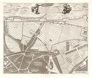
Secunda Tabula Ichnographica
Edité par Milano
Vendeur : Sergio Trippini, Gavirate, Italie
Membre d'association : ALAI ILAB
Evaluation du vendeur :

Pianta planimetrica del quartiere Ticinese.
-
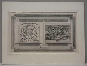
Leicestria Leicester Map Plan & View of Staunton Harold
Edité par A Leide, Chez Pierre vander Aa, Leiden, 1705
Carte
Single sheet thick paper. Etat : Very Good. Edition Unstated. Very good example of this scarce print published circa 1705 The image is sized 400 x 225 mm and can be put under double mount sized 510 x 380 mm as per the illustration and framed to your request. But will be posted as a single piece of paper in a stout tube otherwise. Buy with confidence, support a genuine Independent Bricks & Mortar Real Bookshop and help to preserve our High streets as interesting places to shop. We are Maynard & Bradley CAMBO & PBFA(now lapsed) members here in Leicester City Centre, UK Why on Amazon do most sellers not describe their actual book? Buy with confidence and support a genuine Independent Bricks & Mortar Real Bookshop. We are Maynard & Bradley CAMBO & PBFA(now lapsed) members here in Leicester City Centre. Size: 280 x 215 mm. 1 pages. Item Type: Map. Quantity Available: 1. Shipped Weight: Under 500 grams. Category: Art & Design; Pictures of this item not already displayed here available upon request. Inventory No: 50233.
-
L` Eveche de Liege, suivant les Nouvelles Observatios de Messre del' Academie Royale des Sciences, et. Augmentees deNouveau. A Leide, Chez Pierre Vander Aa Avec Privilege
Edité par Pierre Vander Aa, Amsterdam, 1719
Vendeur : Alexandre Antique Prints, Maps & Books, Toronto, ON, Canada
Membre d'association : ABAC ILAB
Evaluation du vendeur :
Carte
The title cartouche depicts a Miter, and a blacksmith working., Size : 260x380 (mm), 10.24x14.96 (Inches), Black & White Small holes, otherwise in Very Good condition;
-
Carte du Brabant, suivant les Nouvelles Observatios de Messre del' Academie Royale des Sciences, et. Augmentees deNouveau. A Leide, Chez Pierre Vander Aa Avec Privilege.
Edité par Pierre Vander Aa, Amsterdam, 1719
Vendeur : Alexandre Antique Prints, Maps & Books, Toronto, ON, Canada
Membre d'association : ABAC ILAB
Evaluation du vendeur :
Carte
The title cartouche depicts scenes of trade and musicians playing. The map shows the Duchy of Brabant that was dissolved during the French occupation of the Southern Netherlands in 1795., Size : 260x275 (mm), 10.24x10.83 (Inches), Black & White Small holes, otherwise in Very Good condition;
-
Cercle de Westphalie.
Edité par Pierre Vander Aa, Amsterdam, 1719
Vendeur : Alexandre Antique Prints, Maps & Books, Toronto, ON, Canada
Membre d'association : ABAC ILAB
Evaluation du vendeur :
Carte
The title cartouche on the upper left corner of the lower map depicts an artist preparing models for a painting , Size : 262x388 (mm), 10.31x15.28 (Inches), Black & White Small worm holes; otherwise in Very Good condition;
-
Le Piemont. Suivant les nouvelles observations de l'Academie Royale des Sciences.
Edité par Leide, 1713
Carta geografica del Piemonte tratta dalla La Galerie agreable du monde. divisée en LXVI tomes. edita a Leida nel 1713. Incisione in rame, in buono stato di conservazione. Dimensioni: 40,5 x 27,5 cm. Non comune.
-
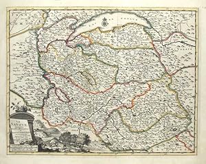
La Savoye
Edité par Savoia
Vendeur : Sergio Trippini, Gavirate, Italie
Membre d'association : ALAI ILAB
Evaluation du vendeur :
Carta geografica della Savoia, confini in coloritura coeva.
-
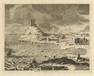
Miseni Promontorium, aliis celebrius
Edité par Bacoli - Miseno (NA)
Vendeur : Sergio Trippini, Gavirate, Italie
Membre d'association : ALAI ILAB
Evaluation du vendeur :
-
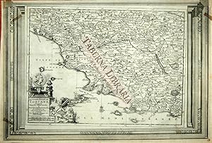
Le Grand Duché de Toscana. Suivant les Nouvelles Observations .
Edité par Leiden, 1715, 1715
Vendeur : TABERNA LIBRARIA - ALAI - ILAB, Pistoia, Italie
Membre d'association : ALAI ILAB
Evaluation du vendeur :

Acquaforte, mm. 260x390 alla battuta. Carta geografica tratta da "La Galerie agreable du monde. divisée en LXVI tomes."edita a Leida nel 1713. Uniformemente arrossata, qualche piccolo difetto. Marg. superiore rifilato al limite della parte incisa.
-
La Moscovie Septentrionale suivant les Nouvelles Observations.
Edité par Leiden, 1709
Vendeur : Alexandre Antique Prints, Maps & Books, Toronto, ON, Canada
Membre d'association : ABAC ILAB
Evaluation du vendeur :
Carte
Etat : Excellent; Size : 232x303 (mm), 9.13x11.93 (Inches), Black & White.
-
La Moscovie Meridionale suivant les Nouvelles Observations.
Edité par Leiden, 1709
Vendeur : Alexandre Antique Prints, Maps & Books, Toronto, ON, Canada
Membre d'association : ABAC ILAB
Evaluation du vendeur :
Carte
Etat : Excellent; Size : 232x303 (mm), 9.13x11.93 (Inches), Black & White.
-
La Boheme / Suivant les Nouvelles Observations de Messrs. de l'Academie Royale des Sciences, etc. / Augmentees de Nouveau a Leide / Chez Pierre Vander Aa. / Avec Privilege.
Edité par Pierre Vander Aa c. 1714, Leiden, 1714
Vendeur : Alexandre Antique Prints, Maps & Books, Toronto, ON, Canada
Membre d'association : ABAC ILAB
Evaluation du vendeur :
Carte
The title cartouche is illustrated with a vignette of the Czech countryside and the Czech coat of arms., Size : 265x392 (mm), 10.43x15.43 (Inches), Hand Colored in Outline Minor wormholing, otherwise in very good condition.
-
La Savoye, Suivant les Nouvelles Observations de Messrs. de l'Academie Royale des Sciences, etc. / Augmentees de Nouveau.
Edité par Pierre Vander Aa c. 1714, Leiden, 1714
Vendeur : Alexandre Antique Prints, Maps & Books, Toronto, ON, Canada
Membre d'association : ABAC ILAB
Evaluation du vendeur :
Carte
The title cartouche is illustrated by a hunting vignette., Size : 261x387 (mm), 10.28x15.24 (Inches), Hand Colored in Outline minor wormholing, otherwise in very good condition.
-
L'Allemagne, Suivant les Nouvelles Observations de Messrs. de l'Academie Royale des Sciences, etc, Augmentees de Nouveau. A Leide, Chez Pierre Vander Aa. / Avec Privilege.
Edité par Pierre Vander Aa c. 1714, Leiden, 1714
Vendeur : Alexandre Antique Prints, Maps & Books, Toronto, ON, Canada
Membre d'association : ABAC ILAB
Evaluation du vendeur :
Carte
Title cartouche is decorated by a German swordsman bearing the German shield, surrounded by army tents and flags., Size : 260x387 (mm), 10.24x15.24 (Inches), Hand Colored in Outline some wormholes, otherwise in very good condition.
-
Brandenbourg et Pomeranie, Suivant les Nouvelles Observations de Messrs. de l'Academi Royale des Sciences, etc. Augmentees de Nouveau, A Leide, Chez Pierre Vander Aa / Avec Privilege.
Edité par Pierre Vander Aa c. 1714, Leiden, 1714
Vendeur : Alexandre Antique Prints, Maps & Books, Toronto, ON, Canada
Membre d'association : ABAC ILAB
Evaluation du vendeur :
Carte
Title cartouche bears the coat of arms of the states represented in this map, including Brandenburg and Pomerania. The title vignette represents a scene of peasant life., Size : 260x385 (mm), 10.24x15.16 (Inches), Hand Colored in Outline Some wormholes, otherwise in very good condition.
-
L`Archeveche de Cologne, suivant les Nouvelles Observatios de Messre del' Academie Royale des Sciences, et. Augmentees deNouveau. A Leide, Chez Pierre Vander Aa Avec Privilege.
Edité par Pierre Vander Aa, Amsterdam, 1719
Vendeur : Alexandre Antique Prints, Maps & Books, Toronto, ON, Canada
Membre d'association : ABAC ILAB
Evaluation du vendeur :
Carte
This map covers a section of western Germany, covering important cities like Bonn, Cologne, Dusseldorf, and Dortmund. The title cartouche depicts the three Magi., Size : 270x385 (mm), 10.63x15.16 (Inches), Black & White Small holes, otherwise in Very Good condition;
-
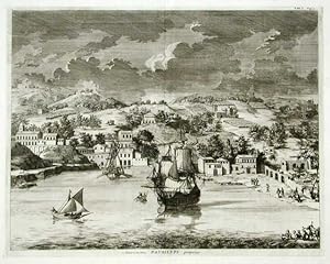
Amoenissimus Pausilypi prospectus
Edité par Posillipo
Vendeur : Sergio Trippini, Gavirate, Italie
Membre d'association : ALAI ILAB
Evaluation du vendeur :
Veduta di Posillipo e del porto, animato da navi.
-
La Grande Tartarie Suivant les Nouvelles Observations de Messrs. De l'Academie Royale des Sciences, etc.
Edité par Pierre Vander Aa c.1715, Leiden, 1715
Vendeur : Alexandre Antique Prints, Maps & Books, Toronto, ON, Canada
Membre d'association : ABAC ILAB
Evaluation du vendeur :
Carte
Etat : Very Good;minor worm holing. Size : 335x405 (mm), 13.125x15.875 (Inches), Hand Colored.
-
Les XVII Provinces des Pays Bas.
Edité par c.1713, Leiden, 1713
Vendeur : Alexandre Antique Prints, Maps & Books, Toronto, ON, Canada
Membre d'association : ABAC ILAB
Evaluation du vendeur :
Carte
Size : 267x392 (mm), 10.51x1.54 (Inches), Hand Colored Very Good, lower margin trimmed, some worm holes mostly at margins.
-
Le Portugal, Suivant les Nouvelles Observations de Messrs. de l'Academie Royale des Sciences, etc. Augmentees de Nouveau a Leide, Chez Pierre Vander Aa, Avec Privilege.
Edité par Pierre Vander Aa c. 1713, Leiden, 1713
Vendeur : Alexandre Antique Prints, Maps & Books, Toronto, ON, Canada
Membre d'association : ABAC ILAB
Evaluation du vendeur :
Carte
A handsome and decorative early 18th century map of Portugal. The cartouche for Portugal depicts a massive coastal trading endeavour, with several tall ships and merchandise., Size : 526x382 (mm), 20.71x15.04 (Inches), Hand Colored in Outline Very good; Laid down on acid-free tissue paper for long term preservation. Few wormholes filled.
-
Turquie en Europe, Suivant les Nouvelles Observations de Messrs. de l'Academie Royale des Sciences, etc. Augmentees de Nouveau a Leide, Chez Pierre Vander Aa, Avec Privilege.
Edité par Pierre Vander Aa c. 1714, Leiden, 1714
Vendeur : Alexandre Antique Prints, Maps & Books, Toronto, ON, Canada
Membre d'association : ABAC ILAB
Evaluation du vendeur :
Carte
Title cartouche depicts traders in Istanbul., Size : 264x382 (mm), 10.39x15.04 (Inches), Hand Colored in Outline Upper margin extended, a crease on the upper left reinforced, otherwise very good, laid down on acid-free tissue paper for long-term preservation.
-
La Suisse, suivant les Nouvelles Observatios de Messre del' Academie Royale des Sciences, et. Augmentees deNouveau. A Leide, Chez Pierre Vander Aa Avec Privilege
Edité par Pierre Vander Aa, Amsterdam, 1719
Vendeur : Alexandre Antique Prints, Maps & Books, Toronto, ON, Canada
Membre d'association : ABAC ILAB
Evaluation du vendeur :
Carte
Etat : Very Good. The title cartouche depicts different Swiss emblems., Size : 260x375 (mm), 10.24x14.76 (Inches), Hand Colored.
-

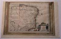
Les Isles Britanniques. 388 x 266 mm plate size
Edité par Leide Leiden, 1729
Vendeur : Finecopy, Westbury, WILTS, Royaume-Uni
Membre d'association : ABA ILAB PBFA
Evaluation du vendeur :
Edition originale
No Binding. Etat : Near Fine. No Jacket. First Edition. Hand coloured map of the British Isles with distinctive Neptune cartouche.Small paper reinforcement verso of lowewr margin else a Fine map with bright contemporary hand colouring.
-
Le Bresil, Suivant les Nouvelles Observations de Messrs de L\'Academie Royale des Sciences etc.
Edité par Pierre Vander Aa c. 1714, Leiden, Holland, 1714
Vendeur : Alexandre Antique Prints, Maps & Books, Toronto, ON, Canada
Membre d'association : ABAC ILAB
Evaluation du vendeur :
Carte
Etat : Very Good; An uncommon map of Brazil published in the large atlas of Vander Aa in early 18th century. Brazil also called Terre De Sainte Croix (Land of the Holy Cross) by Cabral who discovered it in 1500 when blown off-course on his way to India. Captions refer to reports by explorers, deposits of gold and silver topography. The cartouche displays merchandise traded by the Dutch West India Co., with their logo on the sack., Size : 10.5x15.5 (Inches), Hand Colored.
-
L'Angleterre Suivant les Nouvelles Observations de Messrs. de l'Academie Royale des Sciences, etc. Augmentees de Nouveau a Leide, Chez Pierre Vander Aa, Avec Privilege.
Edité par Pierre Vander Aa c. 1713, Leiden, 1713
Vendeur : Alexandre Antique Prints, Maps & Books, Toronto, ON, Canada
Membre d'association : ABAC ILAB
Evaluation du vendeur :
Carte
Title cartouche features tall ships engaged in trade by a shore., Size : 224x298 (mm), 8.82x11.73 (Inches), Hand Colored Minor wormholing present, otherwise very good.
-
Le Royaume de Naples, Suivant les Nouvelles Observations de Messrs. de l'Academie Royale des Sciences, etc. Augmentees de Nouveau a Leide, Chez Pierre Vander Aa, Avec Privilege.
Edité par Pierre Vander Aa c.1713, Leiden, 1713
Vendeur : Alexandre Antique Prints, Maps & Books, Toronto, ON, Canada
Membre d'association : ABAC ILAB
Evaluation du vendeur :
Carte
Fine 18th century map of Southern Italy with a decorative cartouche., Size : 265x395 (mm), 10.43x15.55 (Inches), Hand Colored Minor wormholing present, otherwise very good.