Montant total (1 article articles) :
Destination de la commande :

PTOLEMY; GIROLAMO RUSCELLI (27 résultats)
Passer aux résultats principaux de la recherche
Type d'article
- Tous les types d'articles
- Livres (6)
- Magazines & Périodiques
- Bandes dessinées
- Partitions de musique
- Art, Affiches et Gravures (1)
- Photographies
- Cartes (20)
-
Manuscrits &
Papiers anciens
Etat
Reliure
- Toutes
- Couverture rigide (6)
- Couverture souple
Particularités
Pays
Evaluation du vendeur
-
![Image du vendeur pour La geografia di Claudio Tolomeo Alessandrino (1574) [LeatherBound] mis en vente par True World of Books](https://pictures.abebooks.com/inventory/md/md31657440947.jpg)
La geografia di Claudio Tolomeo Alessandrino (1574) [LeatherBound]
Date d'édition : 2023
Livre impression ŕ la demande
LeatherBound. Etat : New. LeatherBound edition. Condition: New. Reprinted from 1574 edition. Leather Binding on Spine and Corners with Golden leaf printing on spine. Bound in genuine leather with Satin ribbon page markers and Spine with raised gilt bands. A perfect gift for your loved ones. NO changes have been made to the original text. This is NOT a retyped or an ocr'd reprint. Illustrations, Index, if any, are included in black and white. Each page is checked manually before printing. As this print on demand book is reprinted from a very old book, there could be some missing or flawed pages, but we always try to make the book as complete as possible. Fold-outs, if any, are not part of the book. If the original book was published in multiple volumes then this reprint is of only one volume, not the whole set. Sewing binding for longer life, where the book block is actually sewn (smythe sewn/section sewn) with thread before binding which results in a more durable type of binding. Pages: 820 Ptolemy, active 2nd century,Ruscelli, Girolamo, -approximately 1565. Espositioni et introduttioni universali sopra tutta le geografia di Tolomeo,Moleti, Giuseppe, 1531-1588. Discorso universale,Malombra, Gio. (Giovanni), editor,Ziletti, Giordano, active 16th century, printer,Vannoni, Bonifacio, former owner.
-
![Image du vendeur pour Geografia di Claudio Tolomeo Alessandrino [LeatherBound] mis en vente par True World of Books](https://pictures.abebooks.com/inventory/md/md31533286423.jpg)
Geografia di Claudio Tolomeo Alessandrino [LeatherBound]
Date d'édition : 2023
Livre impression ŕ la demande
LeatherBound. Etat : New. LeatherBound edition. Condition: New. Reprinted from 1599 edition. Leather Binding on Spine and Corners with Golden leaf printing on spine. Bound in genuine leather with Satin ribbon page markers and Spine with raised gilt bands. A perfect gift for your loved ones. NO changes have been made to the original text. This is NOT a retyped or an ocr'd reprint. Illustrations, Index, if any, are included in black and white. Each page is checked manually before printing. As this print on demand book is reprinted from a very old book, there could be some missing or flawed pages, but we always try to make the book as complete as possible. Fold-outs, if any, are not part of the book. If the original book was published in multiple volumes then this reprint is of only one volume, not the whole set. Sewing binding for longer life, where the book block is actually sewn (smythe sewn/section sewn) with thread before binding which results in a more durable type of binding. Pages: 882 Language: Italian.
-

Tabula Europae I / D'Europa Prima Tavola. Antica Di Tolomeo.
Edité par c.1574, Venice, 1574
Vendeur : Alexandre Antique Prints, Maps & Books, Toronto, ON, Canada
Membre d'association : ABAC ILAB
Evaluation du vendeur :

Carte
Etat : Very Good. Map of the British Isles ( United Kingdom) based on Ptolemy's map., Size : 190x262 (mm), 7.48x10.31 (Inches), Black & White.
-
Tabula Asiae II / [verso:] Del l'Asia, Tavola seconda antica
Edité par Ruscelli c. 1574, Venice, 1574
Vendeur : Alexandre Antique Prints, Maps & Books, Toronto, ON, Canada
Membre d'association : ABAC ILAB
Evaluation du vendeur :
Carte
Etat : Very Good; Italian text on verso., Size : 188x262 (mm), 7.40x10.31 (Inches), Hand Colored.
-
Tabula Aphricae I / [verso:] Di Libia O Africa Tavola Prima
Edité par Ruscelli c. 1574, Venice, 1574
Vendeur : Alexandre Antique Prints, Maps & Books, Toronto, ON, Canada
Membre d'association : ABAC ILAB
Evaluation du vendeur :
Carte
Etat : Very Good; Italian text on verso., Size : 187x262 (mm), 7.36x10.31 (Inches), Hand Colored.
-
Tabula Aphricae II / [verso:] Di Libia O Africa, Tavola Seconda
Edité par Ruscelli c. 1574, Venice, 1574
Vendeur : Alexandre Antique Prints, Maps & Books, Toronto, ON, Canada
Membre d'association : ABAC ILAB
Evaluation du vendeur :
Carte
Etat : Very Good; Italian text on verso., Size : 190x253 (mm), 7.48x9.96 (Inches), Hand Colored.
-
Tabula Africae III / Di Libia Tavola Terza.
Edité par Ruscelli c. 1574, Venice, 1574
Vendeur : Alexandre Antique Prints, Maps & Books, Toronto, ON, Canada
Membre d'association : ABAC ILAB
Evaluation du vendeur :
Carte
Etat : Very Good; Italian text on verso., Size : 189x261 (mm), 7.44x10.28 (Inches), Hand Colored.
-
Tabula Africae IIII / [verso:] Di Libia, Tavola Quarta
Edité par Ruscelli, Venice, 1561
Vendeur : Alexandre Antique Prints, Maps & Books, Toronto, ON, Canada
Membre d'association : ABAC ILAB
Evaluation du vendeur :
Carte
Etat : Very Good; Italian text on verso., Size : 188x165 (mm), 7.40x6.50 (Inches), Hand Colored.
-
Europae Tabula VIII / [verso:] D'Europa, Ottava Tavola
Edité par Ruscelli c. 1574, Venice, 1574
Vendeur : Alexandre Antique Prints, Maps & Books, Toronto, ON, Canada
Membre d'association : ABAC ILAB
Evaluation du vendeur :
Carte
Etat : Very Good; Italian text on verso., Size : 190x265 (mm), 7.48x10.43 (Inches), Hand Colored.
-
Tavola Nuova di Schiavonia / [verso:] Schiavonia sesta tavola nuova d'Europa.
Edité par Ruscelli c. 1574, Venice, 1574
Vendeur : Alexandre Antique Prints, Maps & Books, Toronto, ON, Canada
Membre d'association : ABAC ILAB
Evaluation du vendeur :
Carte
Etat : Very Good; Italian text on verso., Size : 190x261 (mm), 7.48x10.28 (Inches), Hand Colored.
-
Hispania Nova Tabula / [verso:] Della Spagna secunda tavola d'Europa
Edité par Ruscelli c. 1561, Venice, 1561
Vendeur : Alexandre Antique Prints, Maps & Books, Toronto, ON, Canada
Membre d'association : ABAC ILAB
Evaluation du vendeur :
Carte
Etat : Very Good; Italian text on verso., Size : 195x265 (mm), 7.68x10.43 (Inches), Hand Colored.
-
Tabula Asiae I / Asia, Tavola Prima Antica.
Edité par Ruscelli c. 1574, Venice, 1574
Vendeur : Alexandre Antique Prints, Maps & Books, Toronto, ON, Canada
Membre d'association : ABAC ILAB
Evaluation du vendeur :
Carte
Etat : Very Good; Italian text on verso., Size : 190x266 (mm), 7.48x10.47 (Inches), Hand Colored.
-
Tabula Asiae III / [verso:] Del l'Asia; Tavola Terza.
Edité par Ruscelli c. 1574, Venice, 1574
Vendeur : Alexandre Antique Prints, Maps & Books, Toronto, ON, Canada
Membre d'association : ABAC ILAB
Evaluation du vendeur :
Carte
Etat : Very Good; Italian text on verso., Size : 192x264 (mm), 7.56x10.39 (Inches), Hand Colored.
-
Tabula Asiae VII / Dell'Asia, tavola setima antica.
Edité par Ruscelli c. 1574, Venice, 1574
Vendeur : Alexandre Antique Prints, Maps & Books, Toronto, ON, Canada
Membre d'association : ABAC ILAB
Evaluation du vendeur :
Carte
Etat : Very Good; Italian text on verso., Size : 191x266 (mm), 7.52x10.47 (Inches), Hand Colored.
-
Tabula Asiae IX / Dell'Asia, tavola nona
Edité par Ruscelli c. 1574, Venice, 1574
Vendeur : Alexandre Antique Prints, Maps & Books, Toronto, ON, Canada
Membre d'association : ABAC ILAB
Evaluation du vendeur :
Carte
Etat : Very Good; Italian text on verso., Size : 188x264 (mm), 7.40x10.39 (Inches), Hand Colored.
-
Natolia Nuova Tavola / [verso:] Natolia prima tavola nuova d'Asia.
Edité par Ruscelli c. 1574, Venice, 1574
Vendeur : Alexandre Antique Prints, Maps & Books, Toronto, ON, Canada
Membre d'association : ABAC ILAB
Evaluation du vendeur :
Carte
Etat : Very Good; Italian text on verso., Size : 189x260 (mm), 7.44x10.24 (Inches), Hand Colored.
-
Europae Tabula V / [verso:] D'Europa, Quinta Tavola
Edité par Ruscelli c. 1574, Venice, 1574
Vendeur : Alexandre Antique Prints, Maps & Books, Toronto, ON, Canada
Membre d'association : ABAC ILAB
Evaluation du vendeur :
Carte
Etat : Very Good; Italian text on verso., Size : 186x266 (mm), 7.32x10.47 (Inches), Hand Colored.
-
Europae Tabula VII / D'Europa, Settima Tavola
Edité par Ruscelli c. 1574, Venice, 1574
Vendeur : Alexandre Antique Prints, Maps & Books, Toronto, ON, Canada
Membre d'association : ABAC ILAB
Evaluation du vendeur :
Carte
Etat : Very Good; Italian text on verso., Size : 190x265 (mm), 7.48x10.43 (Inches), Hand Colored.
-
Tabula Europae X / [verso:] D'Europa, Decima Tavola
Edité par Ruscelli c. 1574, Venice, 1574
Vendeur : Alexandre Antique Prints, Maps & Books, Toronto, ON, Canada
Membre d'association : ABAC ILAB
Evaluation du vendeur :
Carte
Etat : Very Good; Italian text on verso., Size : 190x264 (mm), 7.48x10.39 (Inches), Hand Colored.
-
Moschovia Nuova Tavola / [verso:] Moscovia secunda tavola nuova d'Asia.
Edité par Ruscelli c. 1574, Venice, 1574
Vendeur : Alexandre Antique Prints, Maps & Books, Toronto, ON, Canada
Membre d'association : ABAC ILAB
Evaluation du vendeur :
Carte
Etat : Very Good; Italian text on verso., Size : 190x260 (mm), 7.48x10.24 (Inches), Hand Colored.
-
Tabula Asiae IIII / [verso:] Dell'Asia tavola quarta
Edité par Ruscelli c. 1574, Venice, 1574
Vendeur : Alexandre Antique Prints, Maps & Books, Toronto, ON, Canada
Membre d'association : ABAC ILAB
Evaluation du vendeur :
Carte
Etat : Very Good; Italian text on verso., Size : 192x266 (mm), 7.56x10.47 (Inches), Hand Colored.
-
Tabula Asiae VIII / [verso:] Dell'Asia, tavola ottiva
Edité par Ruscelli c. 1574, Venice, 1574
Vendeur : Alexandre Antique Prints, Maps & Books, Toronto, ON, Canada
Membre d'association : ABAC ILAB
Evaluation du vendeur :
Carte
Etat : Very Good; Italian text on verso., Size : 190x260 (mm), 7.48x10.24 (Inches), Hand Colored.
-
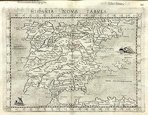
Hispania Nova Tabula - Península Ibérica
Edité par Venecia, 1599
Art / Affiche / Gravure Edition originale
Etat : ACEPTABLE. [Un] Mapa, "Hispania nova tabvla. Della Spagna. Seconda nvova tavola d'Evropa.", parte de la Geografia di Claudio Tolomeo Alessandrino, nuouamente tradotta di Greco in Italiano, da Girolamo Ruscelli . In Venetia, Appresso Vincenzo Valgrisi, M.D.LXI. (1561).", en "Descrittione della Spagna" de Claudius Ptolomeo. Claudio Ptolomeo (87-150) era un astrónomo y geógrafo egipcio que vivió y estudio en Alejandría. Alejandría no sólo era el hogar de la mayor biblioteca del mundo de todas las epocas, sino que era también uno de los centros comerciales más importantes entre el oeste y el este. Aquí Ptolomeo no sólo podía estudiar las autoridades antiguas, sino también consultar a viajeros y comerciantes contemporáneos. De esta riqueza de conocimientos acumulados, Ptolomeo compuso su Geographia, una obra de considerable genio, que dominó todo el mundo cristiano y musulmán durante 1.500 ańos. Fue Ptolomeo quien introdujo el concepto de latitud y longitud para formar una cuadrícula que cubriera el mundo entero, de modo que sería posible trazar la posición de las marcas principales en el mapa mediante observaciones. Por desgracia, Ptolomeo se vio obstaculizado por la escasez de observaciones -como resultado exageró la extensión del Mediterráneo en más de 20 grados- A pesar de estos errores, el trabajo fue de fundamental importancia en un momento en que poco se estaba haciendo en el camino de la cartografía moderna y perduró durante los siguientes 1500 ańos. Ptolomeo se ha ganado la reputación y el elogio como el padre de la geografía. En 1477, se publicó en Bolonia la primera edición impresa de la Geografía de Ptolomeo con mapas. El gran número de ediciones del atlas ptolemaico incluso hasta impresiones tan tarde como 1840, son testimonio de la influencia de Ptolomeo y la popularidad de sus mapas clásicos en las que publicaban los mapas basados casi exclusivamente en su detalle del mundo antiguo. Aunque el contenido cartográfico de los atlas y mapas ptolemaicos era estándar, ciertas ediciones son dignas de comentario: -1477la primera edición con mapas. Bologna. Grabados de planchas cobre. -1482Ulm Ptolomeo. (Primer mapa moderno de Espańa/ mismo ańo que la edición de Florencia). -1482Florencia, Berlinghieri (contiene el primer mapa moderno de Espańa). -1511Edición por Sylvanus en Venecia.(27 mapas antiguos y uno moderno del mundo) -1513Publicado por Martin Waldseemuller, incorporando 20 nuevos mapas, incluyendo el segundo mapa para centrarse en los descubrimientos del Nuevo Mundo. Posiblemente el Atlas mas importante de Ptolomeo. Famosa mención del Mapa del Admiral (C. Colon), Xilografías. Segunda impresión idéntica en 1520. (27 mapas + 20 modernos). Reverso de los mapas en blanco en las dos ediciones. -1522Ilustrado con xilografías grabados por Laurent Fries, cuidadosa reducción de los mapas de Waldseemuller. Segunda edición de 1525 también en Estrasburgo. Se comenta que el reverso de los mapas podría haber sido grabada por A. Durero. -1535 y 1541Reedición con textos nuevos editados por M. Servet.(basado en los de Pirckheimer). Reverso grabado por Holbein. Se diceque ha Servet se le quemó en la hoguera junto a sus libros "controvertidos". 1540-Mapas de Ptolomeo de Sebastian Munster; posteriormente reeditado en una variedad de libros de geografía clásica. 1548-La primera edición en italiano, la primera en miniatura, en cobre, de la geografía de Ptolomeo, que incluye varios mapas nuevos de Gastaldi. 1561- Los mapas de Gastaldi volvieron a publicarse, en un formato un poco más grande, por Ruscelli y Valgrisi en Venecia. 1578-el primer atlas de Mercator con los mapas de Ptolomeo - pretende ser un compańero de su Atlas del Mundo Moderno. Formato (cm): 22,5x32.
-
Geografia di Claudio Tolomeo Alessandrino, Tradotto di Greco nell'Idioma Volgare Italiano da Girolamo Ruscelli, et hora nuouamente ampliata de Gioseffo Rosaccio
Date d'édition : 1599
Vendeur : Maggs Bros. Ltd ABA, ILAB, PBFA, BA, London, Royaume-Uni
Membre d'association : ABA ILAB PBFA
Evaluation du vendeur :

Quarto (227 x 165 mm); [4], [32], 42, 186, 144, [28] leaves, with a woodcut globe and table, text diagrams and sixty-nine maps, twenty-seven Ptolemaic and forty-two modern; the text in three parts, the Geografia, the ?Descrittione della Geografia Universale, con Tavole Quarantadue d?intaglio de rame . con Discorsi fatti da Gioseppe Rosaccio? and ?Espositioni et Introduttioni Universale di Girolamo Ruscelli sopra la Geografia?, 1598. 18th century mottled calf, gilt, with red morocco label and floral decoration to spine. Front joint split at head, some mild worming to spine, extremities rubbed. The title spotted, but the text generally clean. Some light waterstaining towards the rear. Venice : Heirs of Melchior Sessa, Seventh edition of Ruscelli?s version of Ptolemy, the fifth in Italian. As with the 1598 edition, it was edited by Rosaccio, and retains the additional suite of World and Continent maps after Abraham Ortelius. References: Shirley, T.PTOL-10g; Nordenskiold Collection Catalogue, III, 228.
-
La geografia di Claudio Tolomeo alessandrino, nuovamente tradotta di greco in italiano, da Ieronimo Ruscelli, con Espositioni del medesimo, particolari di luogo in luogo, [.] Et con nuove & bellissime figure in istampe di rame, ove, oltre alle XXVI antiche di Tolomeo, se ne son'aggiunte XXXVI altre delle moderne. Con la carta da navicare, & col modo d'intenderla, & d'adoperarla. Aggiuntovi un pieno discorso di M. Gioseppe Moleto matematico. Nel quale si dichiarano tutti i termini & le regole appartenenti alla geografia. Et con vna nuova & copiosa Tavola
Edité par Venezia, Giordano Ziletti, Venezia, 1564
Vendeur : Libreria Alberto Govi di F. Govi Sas, Modena, Italie
Membre d'association : ALAI ILAB
Evaluation du vendeur :
Etat : Buono (Good). WITH 64 ENGRAVED MAPSThree parts (each with a separate title page) in one volume, 4to (mm 212x152). Geografia: [8], 358, [2] pp.; Espositioni et introduttioni universali di Girolamo Ruscelli sopra tutta la Geografia di Tolomeo: [28] leaves, [4: Tavola universale, con la descrittione di tutto il mondo] pp., 27 and XXXVI engraved numbered double plates; Discorso universale di M. Giuseppe Moleto matematico: 47, [49] pp. Signatures: *4 A-YY4; ?-?4 +2 1-272 (2A-2Z2 A1-D42) I-XXXVI2 (3A-Nn2); 4A-4F4 5A-5F4. The edition contains several woodcut diagrams and illustrations in the text (including two portraits of Ptolemy), and overall 64 engraved double-page maps, of which 27 are Ptolemaic and 37 are new. Ziletti's device on title pages, Valgrisi's device after plate XXXVI (l. Nn4v). Later vellum with inked title on spine (endleaves renewed). Tear anciently repaired to l. ?4 with no loss, slightly uniformly browned, some light occasional marginal foxing and staining, short margins, but overall a good copy.Second Ruscelli edition of Ptolemy's Geography, a reprint of the first issued by Vincenzo Valgrisi in 1561. A third edition, revised and corrected by Giovanni Malombra and with the addition of a map (Territoria di Roma), was printed by Ziletti in 1574.Ruscelli was responsible for the Italian translation of the text and for the maps, which he drew reproducing on a larger scale those published by Gastaldi in his 8vo edition of Ptolemy's Geography appeared in 1548. The most important innovation introduced by Ruscelli is the division of the modern globe into two circular hemispheres depicting the New World and the Old World; a feature previously used only by François de Malines in 1528 and later become popular with the famous Mercator globe of 1587. Particularly innovative is also the map of the Arctic regions, in which Ruscelli correctly separates Greenland from Norway, usually depicted as forming a single land.When in 1559 Pius IV commissioned Pirro Ligorio to have a gallery in the Vatican painted with geographical maps, Ruscelli's modern maps were chosen as models for the frescoes.Girolamo Ruscelli, of humble origins, was born in Viterbo and became one of the leading editors of the Cinquecento. He was first active in Rome, where he founded the Accademia dello Sdegno together with Tommaso Spica and Giovanni Andrea dell'Anguillara. He later settled in Venice working for such publishers as Sessa and Valgrisi. He was a friend of Bernardo and Torquato Tasso, Lodovico Dolce and Pietro Aretino. The last two were to become his rivals in several bitter controversies. He edited the works of Boccaccio, Petrarch and Ariosto and translated Ptolemaeus' treatise on geography. While in Venice he had contact with other academies (della Fratta, dei Dubbiosi, della Veniera and della Fama), and was interested in issues such as the systematization of the Italian language (cf. P. Procaccioli, ?Costui chi e' si sia'. Appunti per la biografia, il profilo professionale, la fortuna di Girolamo Ruscelli, in: ?Girolamo Ruscelli. Dall'accademia alla corte alla tipografia. Atti del Convegno internazionale di studi, Viterbo, 6-8 ottobre 2011, Roma, 2012?, pp. 13-76; and C. Di Filippo Bareggi, Il mestiere di scrivere: lavoro intellettuale e mercato librario a Venezia nel Cinquecento, Rome, 1988, pp. 78-80; 296-301).Giuseppe Moleti, born in Messina, Sicily, was an Italian mathematician who held the chair of mathematics at the University of Padua before Galileo (cf. A. Carugo, Giuseppe Moleti: mathematics and the Aristotelian theory of science at Padua in the second half of the 16th-century Italy, in: ?Aristotelismo veneto e scienza moderna. Atti del 25° anno accademico del Centro per la storia della tradizione aristotelica nel Veneto?, L. Olivieri, ed., Padua, 1983, I, pp. 509-517). He also played a key role in the reform of the calendar promoted by Pope Gregory XIII. Moleti also wrote an important dialogue on mechanics and in 1562 (Venice, Valgr. Book.
-
La Geografia di Claudio Tolomeo Alessandrino, Nuouamente tradotta di Greco in Italiano, da Ieronimo Ruscelli; Con Espositioni del medesimo, particolari di luogo in luogo, & uniuersali sopra tutta il libro, & sopra tutta la Geografia, o modo di far la descrittione di tutto il mundo.
Edité par Giordano Ziletti, Venice, 1564
Vendeur : Argosy Book Store, ABAA, ILAB, New York, NY, Etats-Unis
Membre d'association : ABAA ILAB
Evaluation du vendeur :
hardcover. Etat : very good(+). 3 parts in 1. Each part has a separate title page with large printer's device. Part 2: Espositioni et Introduttioni Universali di Girolamo Ruscelli, sopra tutta la Geografia di Tolomeo. Part 3: Discorso Universale di M. Gioseppe Moleto mathematico. Illustrated with 63 (of 64) fine double-leaf copper engraved maps, including the rare "World in Hemispheres". Additional large in-text engravings and decorative initials throughout. [8], 358, [110], [204], [48] index, 47 pages. Short thick 4to, bound in old calf with gilt devices on covers, neatly re-cased (binding well-rubbed but very sound; very clean copy, virtually free of foxing; one map ink stained; lacks the final world map "Carta Marina"), a.e.g. Venetia: Appresso Giordano Ziletti, 1564. Text in Italian. Bookplate of Otto Orren Fisher pasted on inside cover. Manuscript note in ink on title page reads: Ex Libris Stephan Tiapas. Second edition of Ruscelli's Italian translation, very similar to the edition of 1561, and containing the same series of maps. The double- page maps are partly based on those of Jacopo Gastaldi in the edition of 1548, but on a larger scale. According to Nordenskiold, two important innovations were introduced (by the 1561 edition) into cartographical literature. One: the division of the Map of the World in two hemispheres. Two: The re-issue of the Zeno Map of the Arctic Regions, which had appeared first 3 years before. "If the remarkable map in this little work had not received extensive circulation, under the sanction of Ptolemy's name, it would probably have been forgotten. During nearly a whole century it exercised an influence on the mapping of the northern countries, to which there are few parallels in the history of cartography". Girolamo Ruscelli (c. 1504-1566) was a Venetian editor, whose maps are primarily based on those by Jacopo Gastaldi (1548) but with many of his own additions and reproduced on a larger scale. Ruscelli introduces several important innovations in this volume through his 37 "modern" maps, which cover Europe, Africa, Asia and the New World. Ruscelli includes a double hemisphere world map, which was the first of its kind to be used in an atlas, and "Carta Marina Nuova Tavola", a rare sea chart of the world. He includes a revised version of the Zeno map of the Arctic, first published in 1558. The Zeno map describes the purported journey of the author's ancestors in the 1390s to Greenland, Iceland, the mythical islands of Frisland and Icaria, and what is now thought to be Newfoundland and Labrador. While Zeno shows Greenland connected to Norway, Ruscelli has updated the map by eliminating this land bridge. Despite its inaccuracies and inclusion of mythical lands, the Zeno map persisted as the prevailing map of the Arctic and Greenland for many years. Six other New World maps include the South American continent, Brazil, Central America and the Baja Peninsula, the eastern coast of North America, Cuba and Hispaniola. Claudius Ptolemy (90-168 CE) was a Roman geographer and mathematician living in Egypt, who compiled his knowledge and theories about the world's geography into one seminal work. Although his maps did not survive, his mathematical projections and location coordinates did. During the Renaissance revival of Greek and Roman works, "Geographia" was rediscovered by monks and based upon Ptolemy's detailed instructions, the maps were recreated. The first printed edition of "Geographia" with maps was published in Bologna in 1477. A rare and exciting edition for any collector. Sabin 66504.
-
La Geografia di Claudio Tolomeo Alessandrino, Nuouamente tradotta di Greco in Italiano, da Girolamo Ruscelli.
Edité par Vincenzo Valgrisi, Venice, 1561
Vendeur : Argosy Book Store, ABAA, ILAB, New York, NY, Etats-Unis
Membre d'association : ABAA ILAB
Evaluation du vendeur :
hardcover. Etat : very good. Venice: Vincenzo Valgrisi, 1561. 3 parts in 1 volume: "La Geografia" by Ptolemy, Ruscelli's "Espositioni et Introduttioni Universali" and "Discorso Universale di M. Gioseppe Moleto mathematico". Short, thick 4to bound in full contemporary vellum with red speckled edges, modern description pasted on spine. Features 64 double page maps: 27 Ptolemaic maps (showing the ancient world as Ptolemy knew it, including one world map), 37 "modern" maps (with two world maps) and several woodcut diagrams, illustrations and decorative initials. First Italian edition. Binding well-worn at edges. Small wormholes in a few pages of text. Library stamp, manuscript notes, and seal in red ink on title page. Marginal dampstains and occasional foxing, with small pencil and contemporary ink notations in margins and on some maps. In general maps are clean and bright. Bookplate of Otto Orren Fisher and ink inscription dated 1724. Girolamo Ruscelli (c. 1504-1566) was a Venetian editor. He introduces several important innovations in this volume through his 37 "modern" maps, which cover Europe, Africa, Asia and the New World. Ruscelli includes a double hemisphere world map, which was the first of its kind to be used in an atlas, and "Carta Marina Nuova Tavola", a rare sea chart of the world. He includes a revised version of the Zeno map of the Arctic, first published in 1558. The Zeno map describes the purported journey of the author's ancestors in the 1390s to Greenland, Iceland, the mythical islands of Frisland and Icaria, and what is now thought to be Newfoundland and Labrador. While Zeno shows Greenland connected to Norway, Ruscelli has updated the map by eliminating this land bridge. Despite its inaccuracies and inclusion of mythical lands, the Zeno map persisted as the prevailing map of the Arctic and Greenland for many years. Six other New World maps include the South American continent, Brazil, Central America and the Baja Peninsula, the eastern coast of North America, Cuba and Hispaniola. Claudius Ptolemy (90-168 CE) was a Roman geographer and mathematician living in Egypt, who compiled his knowledge and theories about the world's geography into one seminal work. Although his maps did not survive, his mathematical projections and location coordinates did. During the Renaissance revival of Greek and Roman works, "Geographia" was rediscovered by monks and based upon Ptolemy's detailed instructions, the maps were recreated. The first printed edition of "Geographia" with maps was published in Bologna in 1477. A rare and exciting edition for any collector.

![Image du vendeur pour La geografia di Claudio Tolomeo alessandrino, nuovamente tradotta di greco in italiano, da Ieronimo Ruscelli, con Espositioni del medesimo, particolari di luogo in luogo, [.] Et con nuove & bellissime figure in istampe di rame, ove, oltre alle XXVI antiche di Tolomeo, se ne son'aggiunte XXXVI altre delle moderne. Con la carta da navicare, & col modo d'intenderla, & d'adoperarla. Aggiuntovi un pieno discorso di M. Gioseppe Moleto matematico. Nel quale si dichiarano tutti i termini & le regole appartenenti alla geografia. Et con vna nuova & copiosa Tavola mis en vente par Libreria Alberto Govi di F. Govi Sas](https://pictures.abebooks.com/inventory/md/md31654585911.jpg)