Montant total (1 article articles) :
Destination de la commande :

RAPKIN, J (599 résultats)
Passer aux résultats principaux de la recherche
Type d'article
- Tous les types d'articles
- Livres (288)
- Magazines & Périodiques
- Bandes dessinées
- Partitions de musique
- Art, Affiches et Gravures (3)
- Photographies
- Cartes (293)
-
Manuscrits &
Papiers anciens (15)
Etat
Reliure
Particularités
Livraison gratuite
Pays
Evaluation du vendeur
-

A Woman Doctor's Guide to PMS: Essential Facts and Up to the Minute Information on PMS (Books for Women by Women)
Edité par Hyperion, 1994
ISBN 10 : 156282810XISBN 13 : 9781562828103
Vendeur : Wonder Book, Frederick, MD, Etats-Unis
Membre d'association : ABAA ILAB
Evaluation du vendeur :

Livre
Etat : Very Good. Very Good condition. A copy that may have a few cosmetic defects. May also contain light spine creasing or a few markings such as an owner's name, short gifter's inscription or light stamp. Bundled media such as CDs, DVDs, floppy disks or access codes may not be included.
Plus de choix d'achat de la part d'autres vendeurs sur AbeBooks
Offres neuf ŕ partir de EUR 92,21
Offres d'occasion ŕ partir de EUR 5,51
Trouvez également Couverture souple
-

PMS : A Woman Doctor's Guide: Essential Facts and Up-to-the-Minute Information on Premenstrual Syndrome
Edité par Kensington Publishing Corporation, 2000
ISBN 10 : 1575666022ISBN 13 : 9781575666020
Vendeur : Better World Books Ltd, Dunfermline, Royaume-Uni
Evaluation du vendeur :
Livre
Etat : Very Good. Revised edition. Ships from the UK. Former library book; may include library markings. Used book that is in excellent condition. May show signs of wear or have minor defects.
Plus de choix d'achat de la part d'autres vendeurs sur AbeBooks
Offres d'occasion ŕ partir de EUR 4,26
-
Single sheet. Uncoloured map with elaborate border. Original folds. 32 x 26 cm.
-
Single sheet. Uncoloured map with elaborate border. Original folds and a few creases and a few marginal repairs 34 x 26 cm.
-
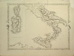
Single sheet. Uncoloured map south of the Papal States with Sicily, Corsica and Sardinia with elaborate border including figures. Just one railway line from Capua to Nola, a distance of 24 miles. Original folds. Very nice condition. 32 x 24 cm.
-

Map Of England & Wales With Original Outline Colour
Edité par J & F. Tallis, London, 1851
Vendeur : Victoria Bookshop, BERE ALSTON, DEVON, Royaume-Uni
Evaluation du vendeur :
Edition originale
Paperback. Etat : Fair. First Edition. The Map With Some Original Outline Colour And With Finely Engraved Decorative Vignette Views Drawn By N. Whitlock And Engraved By J. Rogers Including London, Oxford, Portsmouth Harbour, Doncaster Race Ground, Etc, All Contained Within Decorative Engraved Borders. The Map Also With Engraved Printed Title And Separate Scale Of Distance. Image Size Approx. 245mm X 330mm (9.5in X 13in) With Margins. A little foxed and thumbed. Scribble in pencil on rear. Small ink mark on sussex. Book.
-
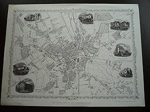
FACSIMILE OF 19th CENTURY PLAN OF BRADFORD, WEST YORKSHIRE
Date d'édition : 1980
Vendeur : K Books Ltd ABA ILAB, York, YORKS, Royaume-Uni
Membre d'association : ABA ILAB PBFA
Evaluation du vendeur :
Livre
No Binding. Etat : Very Good. J Rapkin (illustrateur). Facsimile. Facsimile of a Plan of Bradford, West Yorkshire engraved by Rapkin, in a decorative border, inset with small engravings of Airedale College, St George's Hall, churches, the cemetery, the Infirmary and the Terminus of the Bradford and Halifax Railway. Printed on thin card. This will be posted rolled, in a tube.
-

Guidelines for Successful Exhibiting
Edité par London, 1991
ISBN 10 : 1871777011ISBN 13 : 9781871777017
Vendeur : TAIXTARCHIV Johannes Krings, Aachen, Allemagne
Evaluation du vendeur :

Livre
Broschiert. (Re-printed 1991 (first published March 1985) Published by the British Philatelic Trust in conjunction with the British Philatelic Federation, Melville and Youth Committe, British Philatelic Centre, London. 28 pp. -- Book in good to very good condition, no writings, etc. 0.0.
-
Independent Tartary [Antique Map]
Edité par The London Printing and Publishing Company, London, 1855
Vendeur : Books & Bidders Antiquarian Booksellers, Cleveland, OH, Etats-Unis
Evaluation du vendeur :
Carte
Etat : Very Good. [Map]. Original steel engraved map with decorative boarder and vignettes. Map size with central vertical fold is approx. 11 x 14 inches. Antique map of "Independent Tartary" N.D. (no date, circa 1855). Vignettes of Tartars on a Journey, The Bride Chase, and The Tent. Map scale in British miles. Map drawn and engraved by J. Rapkin, with illustrations by W. Bragg and engraved by J. Rogers. Contemporary pen outlining in color. By 1865 Tallis was among the last of the publishers of beautifully decorated hand engraved maps. Shows some expected page toning and light wear at corners. Map.
-
Map: Bradford, Yorkshire.
Edité par The London Printing and Publishing Company, London. N.d. (1880s) (1960s)., 1960
Carte
No Binding. Etat : Fine. Limited Edition. Reproduction plan or map of Bradford in Fine condition, 1 page, large quarto. The plan was drawn and engraved by J. Rapkin and the illustrations drawn and engraved by H. Winkles. Probably from the 1880s. Has 7 illustrations with the plan of churches, Infirmary, Terminus of the Bradford and Halifax Railway. Overall size is 14"x10.5". Ideal for framing.
-
New Zealand [Antique Map]
Edité par John Tallis, London, 1851
Vendeur : Books & Bidders Antiquarian Booksellers, Cleveland, OH, Etats-Unis
Evaluation du vendeur :
Carte
Etat : Good. [New Zealand Map]. Original steel engraved map with decorative boarder and vignettes. Map size with central vertical fold is 14 x 11 inches. Antique map of "New Zealand" by John Tallis & Company, circa 1851. Vignettes of Auckland, Mount Egmont from New Plymouth, Wellington, and Indigenous person. Map drawn and engraved by John Rapkin, with illustrations by H. Warren and engraved by J.B. Allen. Contemporary pen outlining in color and pale blue coastline wash. By 1865 Tallis was among the last of the publishers of beautifully decorated hand engraved maps. Trimmed at top and bottom, with some light expected page toning. Map.
-
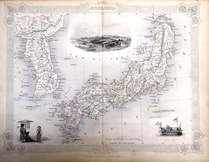
steal engraving / Grenzcolorierter Stahlstich Japan & Corea. Mit 2 Textseite 313/314. und mit weiteren drei BildStahlstichen 1) Coreans. 2) Yedo. 3) State Barge.
Edité par The London Printing and Publishing Company. o.J. [ca 1850], 1850
Vendeur : Antiquariat Carl Wegner, Berlin, B, Allemagne
Membre d'association : GIAQ
Evaluation du vendeur :
Edition originale
Softcover. Blattgröße 27x36 cm, Kartengröße 22 x 29,5 cm, mittig längs gefaltet. Die Tafel mit floraler Rahmung, eingezeichneten Längen- und Breitengraden, Maßstabsangabe. Rückseitig Textseiten 313 und 314 zu Japan (zweispaltig). Das Blatt an den Rändern und in der Querfalte leicht lichtrandig. Das zweiseitige Textblatt zur Hälfte an der Karte klebend, mit leichtem Papierverlust im inneren Seitenbereich. Auf den Textseiten alphabetisch der Buchstabe J mit u.a.: January, Janus, Japan. Jar -Erklärungen. Gutes Exemplar. --- In english language. Good condition. Die Tafel beschriftet mit der Ziffer 45. Wahrscheinlich die entsprechende Tafel aus dem Werk von John Tallis: Illustrated atlas and modern history of the world.-- Zu dekorativen Zwecken, zum Rahmen geeignet. Weitere Karten aus dem gleichen Werk vorhanden. "John Rapkin was a mapmaker who was concerned with the aesthetic value of his work as well as cartographic content. His fine maps are distinguished by the trademark decorative borders, vignettes and title displays. Rapkin worked in close association with the equally respected publisher John Tallis. The publishing rights of many of the maps passed to The London Printing and Publishing Company circa 1850. "-- Bitte Portokosten außerhalb EU erfragen! / Please ask for postage costs outside EU! / S ' il vous plait demander des frais de port en dehors de l ' UE! -- Herzlichen Dank für Ihre Bestellung! Laden3.
-

EL SÍNDROME PREMENSTRUAL. Una guía práctica y definitiva (Barcelona, 1995)
Edité par Oniro
ISBN 10 : 8449301963ISBN 13 : 9788449301964
Livre
Sindrome premenstrual Medicina Psicología Obstetría Ginocología Salud La mujer Dietética Pharmacos Ed. Paidos. Rústica. 159 pags. 16 x 23cm. Índice: El SPM: Los hechos Versus los mitos. żQué es el SPM? ż Sufres de SPM? Terapias dietéticas. żVale la pena el esfuerzo que representan? Cómo enfrentarse al estrés. Terapias farmacológicas. żPuede la histerec GASTOS DE ENVÍO GRATIS (HASTA 1 kilo). Los PEDIDOS DE MENOS DE 6 euros tienen unos gastos de 1 euro. He cerrado la librería. Solo vendo on-line.
Plus de choix d'achat de la part d'autres vendeurs sur AbeBooks
Offres d'occasion ŕ partir de EUR 14,85
-
The Battle of the Alma - Showing the English, French , Russian and Turkish Forces - an Original Antique Engraved Map
Date d'édition : 1860
Vendeur : K Books Ltd ABA ILAB, York, YORKS, Royaume-Uni
Membre d'association : ABA ILAB PBFA
Evaluation du vendeur :
Livre
No Binding. Etat : Very Good. Engraved By J. Rapkin (illustrateur). An original antique engraved map, printed circa 1860. Hand-colouring contemporary. Mounted and ready to frame. A fine opportunity to purchase an attractive and decorative map - The Battle of the Alma - Showing the English, French , Russian and Turkish Forces on the 19th and 20th September, 1854. Lovley decoratively engraved frame.
-
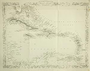
No Binding. Etat : Good. c1860. Published by London Printing And Publishing Company. Description: An antique decorative map of West indies islands drawn and engraved by J. Rapkin. Published by The London Printing and Publishing Company. Condition: Good. Light wear to and creasing to corners and edges. 1cm tear to upper border. 2cm tear to upper right corner and upper end of page gutter from which is was bound in. Creased as orginally folded vertically and horizontally in book. Light spots to upper crease line and margin edges. CARTOGRAPHER: John Rapkin (1815-1876) was a map maker and engraver. J. Rapkin. A nineteenth century map maker and engraver, best known for his work on the Illustrated Atlas of the World 1849-53 for John Tallis and Co. noted for their beautifully decorative borders as well as cartographic content. The maps are distinguished by his trademark decorative borders, vignettes and title displays. Rapkin worked in close association with the publisher John Tallis . The publishing rights of the maps passed to The London Printing and Publishing Company around 1850. ENGRAVER:
-
1851 Map of Peru and Bolivia with Engravings
Edité par J & F Tallis, London, 1851
Vendeur : ! Turtle Creek Books !, Mississauga, ON, Canada
Evaluation du vendeur :
Livre
Soft cover. Etat : Good. Rapkin, J ; Winkles, H ; Kernot (illustrateur). Original 1851 map published by J & F Tallis of London. Gorgeous engravings by J Ripkin, illustratrations by Winkles and Kernot, map drawn and engraved by J. Rapkin. Hand coloured outlines, decorative borders, beautiful engraved vignettes within border edges. This rare map will be exceedingly handsome when properly mounted and framed. Overall dimensions are 14-1/2" x 10-1/2". Bottom edge slightly frayed however this should be addressed once mounted. Cited in Tooley's Dictionary of Maps. Slight age-toning, but still remarkably clean and bright. Bottom right hand corner has been tape repaired. Wonderful vignette illustrations of Potosi, Lima, Swimming Couriers or Peru, Tarija.
-

The Premenstrual Syndromes PMS and PMDD
Edité par Informa Healthcare, London, 2007
ISBN 10 : 0415399742ISBN 13 : 9780415399746
Vendeur : Librakons Rare Books and Collectibles, Istanbul, Turquie
Membre d'association : IOBA
Evaluation du vendeur :

Livre
Hardcover. Etat : Fine. 197pp., 24x18cm., in English.
Plus de choix d'achat de la part d'autres vendeurs sur AbeBooks
Offres neuf ŕ partir de EUR 170,73
Offres d'occasion ŕ partir de EUR 25,16
Trouvez également Couverture rigide Edition originale
-
Asia (ca 1865)
Edité par The London Printing and Publishing Company, 1865
Vendeur : Waimakariri Books and Prints Limited, Oxford, Nouvelle-Zélande
Evaluation du vendeur :
Carte
No Binding. Etat : Good. Map of Asia by J Rapkin, published by The London Printing and Publishing Company ca 1865. Page size 37 x 28.5 cm approx, three folds. Some creasing to the upper part of the page, top right corner sliced off (image not affected), two neat repairs to the verso, otherwise only minor marks/foxing and wear. Presentable, Good Plus overall. Free standard airmail worldwide. This does not include tracking, though the service is available at an extra cost.
-
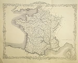
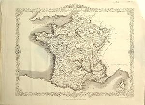
No Binding. Etat : Very Good. c1860. Published by London Printing And Publishing Company. Description: An antique decorative map of the France drawn and engraved by J. Rapkin. Published by The London Printing and Publishing Company. Condition: Very Good. Light wear to corners and edges. Creased as orginally folded vertically and horizontally in book. Creased lower left corner. Very minor nick to lower edge of centre crease with very small tear to upper edg. CARTOGRAPHER: John Rapkin (1815-1876) was a map maker and engraver. J. Rapkin. A nineteenth century map maker and engraver, best known for his work on the Illustrated Atlas of the World 1849-53 for John Tallis and Co. noted for their beautifully decorative borders as well as cartographic content. The maps are distinguished by his trademark decorative borders, vignettes and title displays. Rapkin worked in close association with the publisher John Tallis . The publishing rights of the maps passed to The London Printing and Publishing Company around 1850. ENGRAVER:
-
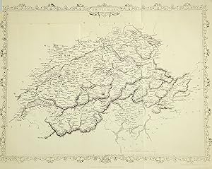
No Binding. Etat : Good. c1860. Published by London Printing And Publishing Company. Description: An antique decorative map of the Swirtzerland drawn and engraved by J. Rapkin. Published by The London Printing and Publishing Company. Condition: Good. Light wear to and creasing to corners and edges. 0.5cm tear to right edge border. Creased as orginally folded vertically and horizontally in book. CARTOGRAPHER: John Rapkin (1815-1876) was a map maker and engraver. J. Rapkin. A nineteenth century map maker and engraver, best known for his work on the Illustrated Atlas of the World 1849-53 for John Tallis and Co. noted for their beautifully decorative borders as well as cartographic content. The maps are distinguished by his trademark decorative borders, vignettes and title displays. Rapkin worked in close association with the publisher John Tallis . The publishing rights of the maps passed to The London Printing and Publishing Company around 1850. ENGRAVER:
-
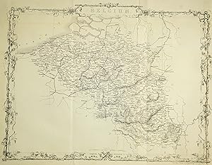
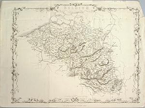
No Binding. Etat : Very Good. c1860. Published by London Printing And Publishing Company. Description: An antique decorative map of the Belgium drawn and engraved by J. Rapkin. Published by The London Printing and Publishing Company. Condition: Very Good. Light wear to corners and edges. Creased as orginally folded vertically and horizontally in boo. CARTOGRAPHER: John Rapkin (1815-1876) was a map maker and engraver. J. Rapkin. A nineteenth century map maker and engraver, best known for his work on the Illustrated Atlas of the World 1849-53 for John Tallis and Co. noted for their beautifully decorative borders as well as cartographic content. The maps are distinguished by his trademark decorative borders, vignettes and title displays. Rapkin worked in close association with the publisher John Tallis . The publishing rights of the maps passed to The London Printing and Publishing Company around 1850. ENGRAVER:
-
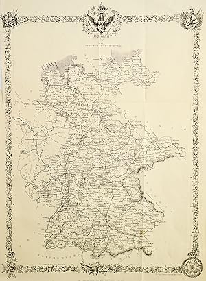
No Binding. Etat : Good. c1860. Published by London Printing And Publishing Company. Description: An antique decorative map of Germany drawn and engraved by J. Rapkin. Published by The London Printing and Publishing Company. Condition: Good. Light wear to and creasing to corners and edges. 1cm tear to upper border. Creased as orginally folded vertically and horizontally in book. Both vertical edges trimmed with very small tear to head of original binding into page gutter. CARTOGRAPHER: John Rapkin (1815-1876) was a map maker and engraver. J. Rapkin. A nineteenth century map maker and engraver, best known for his work on the Illustrated Atlas of the World 1849-53 for John Tallis and Co. noted for their beautifully decorative borders as well as cartographic content. The maps are distinguished by his trademark decorative borders, vignettes and title displays. Rapkin worked in close association with the publisher John Tallis . The publishing rights of the maps passed to The London Printing and Publishing Company around 1850. ENGRAVER:
-
The World - on Mercator's Projection (1860)
Edité par The London Printing and Publishing Company, 1860
Vendeur : Waimakariri Books and Prints Limited, Oxford, Nouvelle-Zélande
Evaluation du vendeur :
Carte Edition originale
Soft cover. Etat : Very Good. 1st Edition. The World - on Mercator's Projection, by J Rapkin, published in LOndon in 1860. An attractive map, centred on the Pacific Ocean and New Zealand in particular. The outline of Antarctica is shown only in part, being largely unknown at that date. Page size 37 x 28 cm approx with several folds. Light wear and marks, with a little wear and disclouration along parts of the folds. small tear to the right hand margin. Price includes standard airmail worldwide. This does not include tracking. If tracking is required, please advise, as an additional charge will be made. Discounts for purchases of multiple titles and for combined postage.
-
INDEPENDENT TARTARY. [A Map]
Vendeur : RARE ORIENTAL BOOK CO., ABAA, ILAB, Aptos, CA, Etats-Unis
Membre d'association : ABAA ILAB
Evaluation du vendeur :

London ca. [1851, London Printing].A single sheet map, very good, usual toning, center folded, outline hand-colored, 26 x 35 cm., illustrated by W. Bragg, engraved by J. Rogers, 3 vignettes, decorative borders, very good. Covers the region on the Eastern side of the Caspian Sea, to Kirghiz Khasaks to the Chinese Empire. Shows also the class- ical areas of Tartary: Kirghiz Middle Horde; Khiva or Khare- sm, Bokhara, Kokand, with good view of the Aral Sea and Lake Balkach. Shows scale in British miles, outline in handcolor. Also covers Turkmenistan, Kazakstan, Uzbekistan). With three vignettes "Tartars on a Journey," "The Tent" and "The Bride Chase a Marriage Custom of the Tartars." This map was done for the J. and F. Tallis atlas. See: Tooley's Dicionary of Maps, S. 528. John Rapkin drew and engraved maps for Tallis 1841-1851.
-
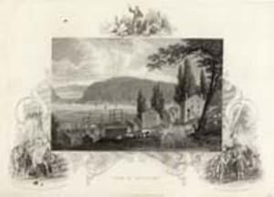
View of Newburgh
Edité par London, 1850
Vendeur : Antipodean Books, Maps & Prints, ABAA, Garrison, NY, Etats-Unis
Membre d'association : ABAA ANZAAB ESA ILAB
Evaluation du vendeur :
Charming pastoral view of early homes, cows, the Hudson & Storm King Mountain in the distance. Steel engraving ca. 1850. B&w image approx 9x7", on paper approx. 10x8". Tallis was known for the handsome vignette views which illustrate the margins of the print, in this case Columbus with the King & Queen of Spain, the Huguenots Landing in America & a preacher exorting native americans.
-
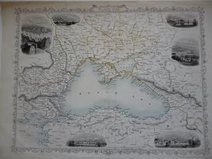
Black Sea
Edité par London Printing and Publishing Co., (London)
Vendeur : Roger Collicott Books, Widecombe in the Moor, DEVON, Royaume-Uni
Evaluation du vendeur :
Carte
Map. Etat : Very Good. Attractive map with minimal original hand colouring with six small vignette views surrounding the map and decorative borders. With light vertical crease marks. Size : 315 x 235 mm.
-
INDEPENDENT TARTARY. Decorative map c1855, partly hand-coloured.
Edité par The London Printing and Publishing Company. No date, 1855
Carte
"The Map Drawn & Engraved by J. Rapkin / The Illustrations by W. Bragg & Engraved by J. Rogers." Steel-engraved map with contemporary hand-coloured outlines, three delicately hand-coloured vignettes (Tartars on a Journey / The Bride Chase - A Marriage Custom of the Tartars / The Tent), and decorative floral border; no centre-fold. Sheet size 273x366mm; cream card mount 350x430mm, opening of size 250x330mm. Blank verso of sheet lightly toned and sparsely spotted, and where attached to mount lightly selotape-marked across tips of lower corners and along narrow strips at upper & lower edges. Map clean, fresh and in VERY GOOD condition.
-
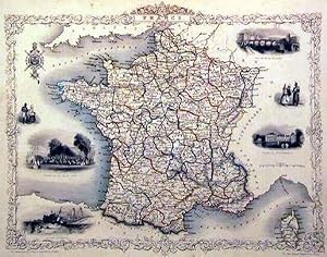
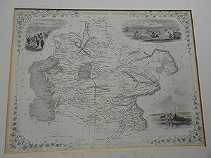
FRANCE
Edité par John Tallis, London, 1851
Vendeur : Harry E Bagley Books Ltd, Fredericton, NB, Canada
Evaluation du vendeur :
Etat : Very Good. original map, showing borders of provinces in color, 6 steel engraved vignettes inside border including; Garden of the Palais Royal; Calais Harbour; Palace of Fontainebleu; and the Bridge of Toulouse, relief is shown by hachures, fold at center,the map drawn & engraved by J. Rapkin, the illustrations by J. Wray & engraved by J. Rogers, very light soil and toning to edges. Size: 29.7 x 21.8 cm.
-
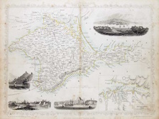
The Crimea / the illustrations, drawn & engraved by H. Winkles ; the map, drawn & engraved by J. Rapkin.
Edité par London Print. and Pub. Co, London
Vendeur : Harry E Bagley Books Ltd, Fredericton, NB, Canada
Evaluation du vendeur :
Carte
No Binding. Etat : Near Fine. no date,(circa 1855) map, measuring, 23 x 32 cm.,light out line colouring, Scale [ca. 1:1,220,000]. center fold, Relief shown by hachures, Includes and inset map of Sevastopol, views of Sevastopol, I?E?vpatorii?a?, banks of the Alma and Balaklava Harbor, Electric telegraph; landing place of the Allied Army, Sepr. 16, 1854.
-
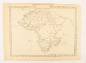
Africa.
Edité par The London Printing and Publishing Company. [Circa1880s]., London., 1880
Vendeur : Asia Bookroom ANZAAB/ILAB, Canberra, ACT, Australie
Membre d'association : ANZAAB ILAB
Evaluation du vendeur :
Printed map, 24 x 32.1 cm, decorative border, two original vertical folds, paper toned, mainly at the edges, inner margin of the sheet ragged, but in good order. A late edition of the map used for the well-known Tallis map, this without the characteristic vignettes and on thinner paper.

![Image du vendeur pour Independent Tartary [Antique Map] mis en vente par Books & Bidders Antiquarian Booksellers](https://pictures.abebooks.com/inventory/md/md31800635682.jpg)
![Image du vendeur pour New Zealand [Antique Map] mis en vente par Books & Bidders Antiquarian Booksellers](https://pictures.abebooks.com/inventory/md/md31800637588.jpg)