Montant total (1 article articles) :
Destination de la commande :

S AUGUSTUS MITCHELL PUBLISHER (5 résultats)
Passer aux résultats principaux de la recherche
Type d'article
- Tous les types d'articles
- Livres (4)
- Magazines & Périodiques
- Bandes dessinées
- Partitions de musique
- Art, Affiches et Gravures
- Photographies
- Cartes (1)
-
Manuscrits &
Papiers anciens
Etat
- Tous
- Neuf
- Ancien ou d'occasion
Reliure
- Toutes
- Couverture rigide (4)
- Couverture souple
Particularités
- Edition originale (2)
- Signé
- Jaquette
- Avec images (2)
- Sans impression ŕ la demande
Pays
Evaluation du vendeur
-

Map of the Western Hemisphere with Time Table
Edité par S. Augustus Mitchell 1874-1881 no place given, 1881
Vendeur : Prairie Archives, Springfield, IL, Etats-Unis
Membre d'association : MWABA
Evaluation du vendeur :

Good plus or better, light general wear 15" x 12 1/2" Images of all maps available upon request.
-
AN ACCOMPANIMENT TO MITCHELL'S REFERENCE MAP OF THE UNITED STATES; Containing an Index of the Various Counties, Districts, Parishes, Towships, Towns, etc. and an Index of the Rivers; together with a Geographical Description of Every State and Territory in the Union; also an Accurate Synopsis of the Population in the Year 1840, According to the Sixth Census, Alphabetically Arranged, in Addition to which, there are a Variety of Statistacal Aggregates, Accounts of Railroads and Canals, Colleges, &c. and a Synopsis of the New Postage Law.
Edité par S. Augustus Mitchell,, Philadelphia, 1848
Vendeur : Voltaire and Rousseau Bookshop, Glasgow, Royaume-Uni
Evaluation du vendeur :

Livre
Hardcover. Etat : Fair. No Jacket. (Ref. O2) Half green leather bound to marbled effect paper covered boards. Rear board is detached and front board is loose with cracked hinge. Rubbing to extremities, worn corners, edges. Head and heel of spine worn, with some short tears, a couple of which have been repaired. Scuffing, fading to rear and front surface. Cup ring visible on rear board. Heavily foxed prelims and slighlty more moderately throughout.
-
Hardcover. Etat : Very Good. 1st Edition. 32mo (3 1/4" by 5 3/8"), green embossed leather binding with gilt lettering, small holes in spine, a color fold-out map (17 1/2" by 21 1/2") with county populations in 1840.
-
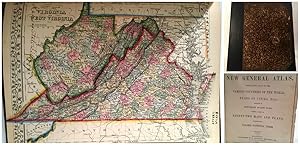
Mitchell's New General Atlas
Edité par S. Augustus Mitchell, Philadelphia, 1866
Vendeur : Oddfellow's Fine Books and Collectables, Topeka, KS, Etats-Unis
Membre d'association : IOBA
Evaluation du vendeur :
Edition originale
Hardcover. Etat : Good+. Etat de la jaquette : No Dust Jacket. First Edition; 2nd State. Ex-Library with minimal (Kansas State Library) markings limited to a stamp in blue ink and catalog information in pencil on the title page, an additional stamp with penned number on the title page verso, stamp and penned library name on the VA/WV map and a small number line in pencil at the rear end page and in the blank margin of 2 maps; no markings found over any maps other than Virginia/West Virginia. Repaired binding includes archival end pages and a reinforced spine. The map of Pennsylvania has a tape repair to the fore edge (map bottom) that very slightly covers the map boarder. All other maps remain complete and clean though a few pages have small smudges, tears and/or chips in the boarders and at edges. In this edition, the southern point of Nevada is still part of Arizona Territory, the Texas panhandle remains part of Oklahoma Territory and Wyoming, though labeled, is still included within Dacotah Territory. Of the remaining maps, most are from either the 1860 or 1865 editions. Includes all 44 states, U. S. Cities and possessions and world maps.; Folio 13" - 23" tall.
-
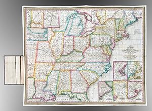
Mitchell's Travellers Guide Through the United States. A Map of the Roads, Distances, Steam Boat & Canal Routes
Edité par S. Augustus Mitchell, Philadelphia, 1833
Vendeur : Donald A. Heald Rare Books (ABAA), New York, NY, Etats-Unis
Membre d'association : ABAA ILAB
Evaluation du vendeur :
Carte
Engraved folding map, period hand-colouring in outline. Nine inset maps. Large folding Index sheet. Folds into publisher's dark green morocco covers, covers bordered in gilt, title stamped in gilt on the upper cover. Mitchell's Travellers Guide, with the large map of the U.S. The map, with the borders of the states brightly colored, shows the Northeast, west to Missouri Territory and part of Mexico, including the Great Lakes region, and south through part of Florida. Insets show the vicinities of Niagara, New Orleans, Cincinnati, Albany, New York, Baltimore and Washington, Philadelphia, Charleston, and Boston. The large folding Index sheet includes much information on steamboat and canal routes, and various statistics. This copy very good condition for a guide generally found quite worn. This is the second edition, preceded only by that of 1832. Rumsey 4374; Howes M690; Clark III:74; Graff 4790.