Montant total (1 article articles) :
Destination de la commande :

SCHENK, PIETER VALK, GERARD (12 résultats)
Passer aux résultats principaux de la recherche
Type d'article
- Tous les types d'articles
- Livres (4)
- Magazines & Périodiques
- Bandes dessinées
- Partitions de musique
- Art, Affiches et Gravures (4)
- Photographies
- Cartes (4)
-
Manuscrits &
Papiers anciens
Etat
- Tous
- Neuf
- Ancien ou d'occasion
Reliure
- Toutes
- Couverture rigide (1)
- Couverture souple
Particularités
- Edition originale
- Signé
- Jaquette
- Avec images (11)
- Sans impression ŕ la demande
Pays
Evaluation du vendeur
-

Tarraconensis
Edité par c1690, 1690
Vendeur : Peter Harrington. ABA/ ILAB., London, Royaume-Uni
Membre d'association : ABA ILAB PBFA
Evaluation du vendeur :

Two ornamental cartouches, flanked with cherubs, one contains the title, the other the scale, both on top of map. North is to the right of map Copper engraving. Original colour. Very good condition, excellent margins, slight browning along centrefold. Size: 50 x 33.5 cm. (19˝ x 13 inches).
-
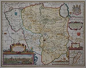
Osnabrugensis Episcopatus. Auctore Ioanne Gigante
Date d'édition : 1700
Vendeur : Kunstantiquariat Andreas Senger, Hamburg, Allemagne
Evaluation du vendeur :
Carte
Kein Einband. Etat : Gut. Es handelt sich hierbei um eine originale, kolorierte Kupferstichlandkarte des Bistums Osnabrück von Valk & Schenk, um das Jahr 1700. *** Titel: Osnabrugensis Episcopatus. Auctore Ioanne Gigante Ort: Bistum Osnabrück *** Kartograph: Pieter Schenk (1660 - 1711) und Gerard Valk (1652 - 1726) nach Willem Janszoon Blaeu (1571 - 1638) *** Jahr: ca. 1700 *** Größe des Plattenbereichs: 37 x 48 cm *** Technik: Kupferstich Zustand (Perfekt/ Sehr gut/ Gut/ Ordentlich/ Mäßig/ Schlecht): In gutem Erhaltungszustand. Mittelfalte hinterlegt. *** Bemerkungen: Aktualisierte Ausgabe der von Blaeu um 1640 veröffentlichten Karte. - - - International buyers welcome. If you have any questions, please don't hesitate to ask. --- Auf Wunsch stellen wir Ihnen gerne ein kostenfreies Echtheitszertifikat aus --- If you wish, we will gladly provide a certificate of authenticity free of charge ---.
-
Dwinae Fluvii nova descriptio
Edité par Amsterdam, 1720
Vendeur : Alexandre Antique Prints, Maps & Books, Toronto, ON, Canada
Membre d'association : ABAC ILAB
Evaluation du vendeur :

Carte
Etat : Excellent. A rare, and important map of the course of the river Dwinae., Size : 460x540 (mm), 18.125x21.25 (Inches), Original Hand Coloring.
-
Lochabria
Edité par c1690, 1690
Vendeur : Peter Harrington. ABA/ ILAB., London, Royaume-Uni
Membre d'association : ABA ILAB PBFA
Evaluation du vendeur :
A beautiful Blaeu style map with galleons in the sea. Copper engraving. Hand coloured. Fine condition. Mounted size: 73 x 66 cm Size: 52 x 43 cm. (20˝ x 17 inches).
-
Etat : ACEPTABLE. Apud G. Valk et O. Schenk. Amstelaed. Atlas Contractus Formato (cm): 50x42.
-
Etat : ACEPTABLE. Apud G Valk et P Schenk (2) Atlas Contractus Formato (cm): 47x37.
-
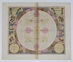
Theoria Lunae, Eius Motu, per Eccentricum et Epicullum Demonstrans, PL. 18
Date d'édition : 1700
Carte
No Binding. Etat : As New. 52.50 x 64 cm. dated 17c.
-
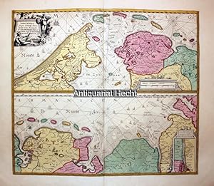
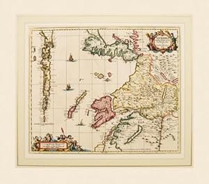
TABULA NOVA In qua accurate demonstratur tota Navigatio ab Amstelodami statione per Vada vulgo de Watten Hamburgum. Kolorierte Kupferstich-Karte von Schenk / Valk.
Edité par Amsterdam: Ottens, um 1740., 1740
Vendeur : Altstadt-Antiquariat Nowicki-Hecht UG, Leer, NDS, Allemagne
Membre d'association : GIAQ
Evaluation du vendeur :
Carte
Blattgröße ca. 56 x 46 cm; Etat : Gut. Die Karte zeigt in zwei Teilen die holländische und westfriesische Küste mit den Inseln (oberer Kartenteil) sowie die ostfriesische Küste vom Dollart bis zur Halbinsel Eiderstedt mit den ostfriesischen Inseln (unterer Kartenteil). Zahlreiche Segelschiffe, zwei Windrosen, oben links schöne Titelkartusche, mittig Meilenzeiger (beide unkoloriert), unten rechts Nebenkarte der Elbe von Hamburg bis Assel (Aasel) und Kollmar (Colmar). Diese Karte, auch Wattenmeerkarte genannt, erschien zuerst im Atlas bei J. Janssonius, hier vorliegend aus dem Atlas Minor von Reiner und Josua Ottens. Sie ist nicht, wie man es aus dem Titel vermuten könnte, eine Seekarte, dazu fehlen die wichtigen Angaben wie Fahrwassertiefe u.a., sondern eine Atlaskarte, die eine in der damaligen Zeit wichtige Schiffsroute der südlichen Nordsee zeigt. Bereits 1666 ist diese Karte mit anderer Titelkartusche (Nieuwe Caerte waerinne vertoont wordt de gantsche Vaert van Amsterdam over de Watten tot de stadt Hamborch toe. Den liefhebberen enden reysenden luyden tot nut en vermaeck int coper gesneden door Ian Ianßen), gestochen von Janßonius, erschienen. // Zustand: Sehr gut, kräftiger Falz mittig. Sehr dekorativ. // Die Karte ist unter Glas mit Passepartout gerahmt und wird ausgerahmt verschickt. Aufpreis für Rahmung: 120,- . /galerie Sprache: Deutsch Gewicht in Gramm: 5100.
-
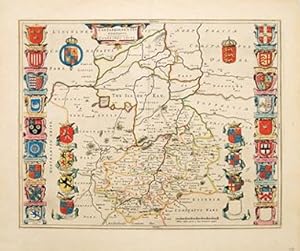
CANTABRIGIENSIS COMITATUS CAMBRIDGE SHIRE Cambridgeshire
Edité par Atlas Anglois. D Mortier. 1715, 1715
Vendeur : Peter Harrington. ABA/ ILAB., London, Royaume-Uni
Membre d'association : ABA ILAB PBFA
Evaluation du vendeur :
A beautiful map of the county, rich with heraldry. Shows the bordering counties Copper engraving. Original colour. Fine condition, good margins. Size: 52 x 42 cm. (20˝ x 16˝ inches).
-
Etat : ACEPTABLE. Amstelodami Venditant Gerardus Valk et Petrus Schenk Atlas Contractus Formato (cm): 48x37.
-
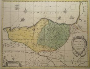
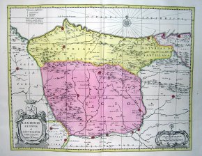
Biscaia et Guipuscoa Cantabriae veteris pars
Edité par c.1700, Amsterdam, 1700
Art / Affiche / Gravure
Etat : ACEPTABLE. Edicion de Valk de los mapas de Blaeu, con pequeńas variantes. Mas raro. Formato (cm): 50x40.
-

Atlantis Sylloge Compendiosa: Cuius in Chartarum Serie, Hic Notes Quod Hasce: A Septentrione Usque Austrum, Descendendo per Earum Latitudines.
Edité par Amsterdam: G. Valck and P. Schenk, 1709., 1709
Vendeur : Arader Galleries - AraderNYC, New York, NY, Etats-Unis
Evaluation du vendeur :
Folio (20 2/8 x 13 inches). Letterpress title-page with list of contents. Additional engraved allegorical title-page with original hand-colour in full, 99 double-page engraved maps (index including title as first map) with original hand-colour in part (a few very small wormholes at lower edge affecting title and first 13 maps and very small wormhole in upper margin of last 10 maps not affecting engraved area). Fine contemporary Dutch speckled calf, the spine in 9 compartments with 8 raised bands, gilt morocco lettering-piece in one, the others decorated with fine gilt astrolabe tool (spine ends and corners with early repairs). Provenance: with the 20th-century woodcut bookplate of C.J. Tencate on the front paste-down; Christopher Henry Beaumont Pease, Lord Wardington (1924-2005), Library of Important Atlases and Geographies, his sale Sothebys' 10th October 2006, lot 518 A later issue, but a FINE AND ATTRACTIVE COPY. "The first issue is thought to be about 1702, and in this, as in the present copy, the vast majority of maps bear the imprint of Valk and Schenk, as does the atlas of Cellarius produced in 1708, and David Mortier's "Atlas Anglois" in 1715. The maps with dates are from 1683, 1703, 1705 and 1707" (Wardington Catalogue). Gerard Valk and his son Leonard were printers, engravers and globe-makers in Amsterdam, closely linked by marriage with the Schenk family with whom they also had a long business association in map engraving and publishing. With their co-publishers, the Schenk family was amongst the most prolific and best-known publishers of eighteenth-century Amsterdam. Many of the atlases they produced were primarily reissues from earlier printing plates that the family purchased from other cartographers. Their work, though often not original, is finely presented and demonstrates the precision and elegance associated with maps and engravings produced in the period. From the distinguished library of Lord Wardington whose collection of Atlases was unique: "a panoply of the history of cartography and of great mapmakers" (Andrew Phillips "An Appreciation", Sotheby's sale catalogue). Catalogued by Kate Hunter.