Montant total (1 article articles) :
Destination de la commande :

TANNER, H ENRY S (5 résultats)
Passer aux résultats principaux de la recherche
Type d'article
- Tous les types d'articles
- Livres (2)
- Magazines & Périodiques
- Bandes dessinées
- Partitions de musique
- Art, Affiches et Gravures
- Photographies
- Cartes (3)
-
Manuscrits &
Papiers anciens
Etat
- Tous
- Neuf
- Ancien ou d'occasion
Reliure
- Toutes
- Couverture rigide (2)
- Couverture souple
Particularités
- Edition originale (2)
- Signé
- Jaquette
- Avec images (4)
- Sans impression ŕ la demande
Pays
Evaluation du vendeur
-
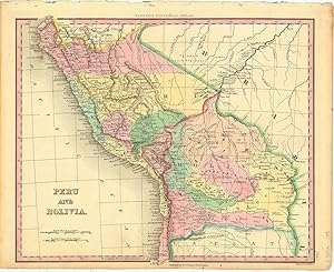
Peru and Bolivia.
Edité par PhiladelphiaTanner. -46, 1836
Vendeur : Robert Frew Ltd. ABA ILAB, London, Royaume-Uni
Membre d'association : ABA ILAB PBFA
Evaluation du vendeur :

Carte
29 x 35 cm. Original colour. Single page map of Peru and Bolivia. Very good condition.
-
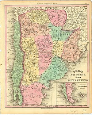
Chile La Plata And Montevideo.
Edité par PhiladelphiaTanner. -46, 1836
Vendeur : Robert Frew Ltd. ABA ILAB, London, Royaume-Uni
Membre d'association : ABA ILAB PBFA
Evaluation du vendeur :
Carte
35.9 x 29.5 cm. Original colour. Single page map of the southern half of South America, encompassing Argentina, Chile, Paraguay and Uruguay. Inset map showing the soutjern extension of the continent into Patagonia and Tierra del Fuego. Very good condition.
-

New Picture of Philadelphia
Date d'édition : 1840
Vendeur : G.S. MacManus Co., ABAA, Bryn Mawr, PA, Etats-Unis
Membre d'association : ABAA ILAB
Evaluation du vendeur :
Edition originale
(PHILADELPHIA). TANNER, H[enry] S[chenck]. A New Picture of Philadelphia, or the Stranger's Guide to the City and Adjoining Districts; In Which Are Described the Public Buildings; Literary, Scientific, Commercial and Benevolent Institutions; Places of Amusement; Places of Worship; Principal Cemeteries, and Every Other Object Worthy of Attention. With a Plan of the City, and Map of Its Environs. Phila.: H. Tanner, Jun'r, 1840. 1st ed. 156 pp. 2 folding maps. Orig. blind-stamped cloth, gilt title on front cover. Cloth a bit worn at the corners and spine ends. Map at the rear with later tape repair along a portion of two folds; otherwise, only minor closed tears. A very good copy of a difficult book to find with both city plan and map. American Imprints 40-6430. Scarce in the trade. OCLC locates 10 copies. The frontispiece map is a plan of the city in 1840 in two colors. The "Map of Philadelphia and Adjacent Country: 1840" shows the city and its western suburbs from Andalusia in the North to Chester in the South, and Norristown to the West. Includes descriptions of churches, bath houses, steamboats, hospitals, asylums, and cemeteries.
-
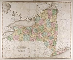
New York
Edité par H. S. Tanner, Philadelphia, 1825
Vendeur : Donald A. Heald Rare Books (ABAA), New York, NY, Etats-Unis
Membre d'association : ABAA ILAB
Evaluation du vendeur :
Carte
Engraved with full, period colour. Mild off-set throughout. Repaired 6" split at bottom of center fold. A fine example of Tanner's updated map of New York. Henry Tanner's A New American Atlas, was the most distinguished atlas published in America during the nineteenth century. The maps were carefully constructed from the best and most recent surveys. They were finely engraved on a large-scale, printed on high quality paper, and carefully hand coloured. Because of the great expense involved in the production and publication, the atlas was published in five parts between 1819 and 1823. It was an ambitious project but one clearly called for as the country rapidly expanded. Western New York was among the first "western" regions of the United States on which people speculated. It was generally supposed to be better for agriculture than in fact it was; many farms were abandoned by their owners. One of the major factors in the future prosperity of the state was the Erie Canal, which opened in 1825, the year this atlas was published. The route of the "Gr. Canal" is depicted here as are the major roadways in the state. Phillips, Atlases, 3669-9; cf. Ristow, American Maps and Mapmakers, pp.191-198; Rumsey 2755.009; cf. Sabin 94323.
-
A New American Atlas containing Maps of the Several States of the North American Union, projected and drawn on a uniform scale from documents found in public offices of the United States and State Governments, and other original and authentic information by Henry S. Tanner
Edité par H.S. Tanner, Philadelphia, 1823
Vendeur : Donald A. Heald Rare Books (ABAA), New York, NY, Etats-Unis
Membre d'association : ABAA ILAB
Evaluation du vendeur :
Edition originale
Folio. (24 x 16 3/4 inches). Letterpress half-title, 1p. index and 18pp. text. Engraved title with vignette of the "First Landing of Columbus in the New World", 18 fine hand-coloured engraved maps (16 double-page, 2 folding). Expertly bound to style in half-calf over contemporary marbled paper-covered boards, the flat spine gilt and divided into seven compartments by fillets and roll tools, lettered in the second compartment, the others with repeat decoration in gilt, marbled endpapers A fine copy of the first collected edition of "the most distinguished atlas published in the United States during the engraving period" (Ristow). Tanner's New American Atlas contained the most accomplished series of maps of America that had yet appeared in an atlas. Of the greatest importance were the maps of American states. These maps were drawn up using a careful combination of original surveys and the best existing published sources. The evident high cost of production meant that the publishers took the decision to issue the maps in five separate parts which were published from 1819 to 1823. A second revised edition appeared in 1825. The maps, all of which are carefully hand-coloured, include a double-page world map, 4 double-page maps of continents, a map of South America on two joined sheets (numbered 6 and 7 in the index), a map of North America on 4 joined sheets (numbered 8 -11) and 11 double-page maps of the various States. The very large map of North America is of particular beauty and note. Wheat writes: "This map was a landmark - a great cartographical achievement . Tanner made good use of a large number of intervening map, those of interest here being Humboldt's 'New Spain,' Pike's various maps, Long's map, and Pedro Walker's 'Map of New California' . This 1822 map of North America was the progenitor of a long line of famous maps" (Wheat, II: pp. 82-87). Contemporary reviews of the atlas were favourable: the New American Atlas "is decidedly one of the most splendid works of the kind ever executed in this country" (United States Gazette, September 1823). Never "has either America or Europe, produced a geographical description of the several States of the Union, so honorable to the Arts, and so creditable to the nation as Tanner's American Atlas." (National Advocate 25 August 1824). Perhaps the most enthusiastic report came from the scholar Jared Sparks who wrote in the April 1824 issue of the North American Review that "as an American Atlas, we believe Mr. Tanner's work to hold a rank far above any other, which has been published." Howes T29; Phillips 1374; cf. Ristow American Maps and Map Makers pp. 154 &193-198; Rumsey 2892; Sabin 94319; Wheat, Mapping the Transmississippi West 350; Schwartz and Ehrenberg p.251.