
Montant total (1 article articles) :
Destination de la commande :

TAYLOR, GEORGE & ANDREW SKINNER (495 résultats)
Passer aux résultats principaux de la recherche
Type d'article
- Tous les types d'articles
- Livres (17)
- Magazines & Périodiques
- Bandes dessinées
- Partitions de musique
- Art, Affiches et Gravures (1)
- Photographies
- Cartes (477)
-
Manuscrits &
Papiers anciens
Etat
Reliure
Particularités
Pays
Evaluation du vendeur
-
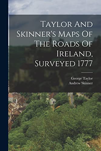
Taylor And Skinner's Maps Of The Roads Of Ireland, Surveyed 1777
Edité par Legare Street Press, 2022
ISBN 10 : 1015623816ISBN 13 : 9781015623811
Livre
Etat : As New. Unread book in perfect condition.
Plus de choix d'achat de la part d'autres vendeurs sur AbeBooks
Offres neuf ŕ partir de EUR 25,30
Offres d'occasion ŕ partir de EUR 24,43
Trouvez également Couverture souple
-

TAYLOR AND SKINNER'S MAPS OF THE ROADS OF IRELAND SURVEYED IN 1777
Edité par Paperbackshop, UK
Livre
Soft cover. Etat : New. Exact facsimile of 1778 original. xvi+288pp+16pp. CLEAN!.
-
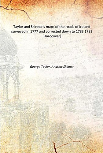
Taylor and Skinner's maps of the roads of Ireland surveyed in 1777 and corrected down to 1783 1783 [Hardcover]
Edité par Facsimile Publisher, 2016
ISBN 10 : 933360796XISBN 13 : 9789333607964
Livre
Etat : New. pp. 334.
Plus de choix d'achat de la part d'autres vendeurs sur AbeBooks
Offres neuf ŕ partir de EUR 30,56
-
[Road from Dublin to Killala to Roscommon by Lanesboro & to Boyle by Strokestown] from Dublin to. page 71 Shows the Road to Boyle
Date d'édition : 1778
Carte
Etat : Good. #68 Lanesborough Killashee Termonbarry Strokestown. TAYLOR/SKINNER 1778 map. Antique copperplate road map; George Taylor & Andrew Skinner (1778). 23.0 x 13.0cm, 9 x 5.25 inches. Condition: Good. There is another map printed on the reverse side: #67 [Road] from Dublin to Killala [to Roscommon by Lanesboro & to Boyle by Strokestown] which includes the towns of Keenagh, Ballymahon, Moyvoughly, Ballynacargy and covers part of the counties of Westmeath, Longford. The map includes the towns of Lanesborough, Killashee, Termonbarry, Strokestown and covers part of the counties of Roscommon, Longford.
-
[Road] from Dublin to Killala [to Roscommon by Lanesboro & to Boyle by Strokestown]
Date d'édition : 1778
Carte
Etat : Good. #67 Dublin to Killala. Keenagh Ballymahon Ballynacargy. TAYLOR/SKINNER 1778 map. Antique copperplate road map; George Taylor & Andrew Skinner (1778). 23.0 x 13.0cm, 9 x 5 inches. Condition: Good. There is another map printed on the reverse side: #68 [Road from Dublin to Killala to Roscommon by Lanesboro & to Boyle by Strokestown] from Dublin to. page 71 Shows the Road to Boyle which includes the towns of Lanesborough, Killashee, Termonbarry, Strokestown and covers part of the counties of Roscommon, Longford. The map includes the towns of Keenagh, Ballymahon, Moyvoughly, Ballynacargy and covers part of the counties of Westmeath, Longford.
-
![Image du vendeur pour Taylor and Skinner's Maps of the Roads of Ireland, Surveyed 1777 1778 [LeatherBound] mis en vente par True World of Books](https://pictures.abebooks.com/inventory/md/md31617570128.jpg)
Taylor and Skinner's Maps of the Roads of Ireland, Surveyed 1777 1778 [LeatherBound]
Date d'édition : 2023
Livre impression ŕ la demande
LeatherBound. Etat : New. LeatherBound edition. Condition: New. Reprinted from edition. Leather Binding on Spine and Corners with Golden leaf printing on spine. Bound in genuine leather with Satin ribbon page markers and Spine with raised gilt bands. A perfect gift for your loved ones. NO changes have been made to the original text. This is NOT a retyped or an ocr'd reprint. Illustrations, Index, if any, are included in black and white. Each page is checked manually before printing. As this print on demand book is reprinted from a very old book, there could be some missing or flawed pages, but we always try to make the book as complete as possible. Fold-outs, if any, are not part of the book. If the original book was published in multiple volumes then this reprint is of only one volume, not the whole set. Sewing binding for longer life, where the book block is actually sewn (smythe sewn/section sewn) with thread before binding which results in a more durable type of binding. Pages: 319.
-
![Image du vendeur pour Taylor and Skinner's maps of the roads of Ireland : surveyed in 1777 and corrected down to 1783 [LeatherBound] mis en vente par True World of Books](https://pictures.abebooks.com/inventory/md/md31533855922.jpg)
Taylor and Skinner's maps of the roads of Ireland : surveyed in 1777 and corrected down to 1783 [LeatherBound]
Date d'édition : 2023
Livre impression ŕ la demande
LeatherBound. Etat : New. LeatherBound edition. Condition: New. Reprinted from 1783 edition. Leather Binding on Spine and Corners with Golden leaf printing on spine. Bound in genuine leather with Satin ribbon page markers and Spine with raised gilt bands. A perfect gift for your loved ones. NO changes have been made to the original text. This is NOT a retyped or an ocr'd reprint. Illustrations, Index, if any, are included in black and white. Each page is checked manually before printing. As this print on demand book is reprinted from a very old book, there could be some missing or flawed pages, but we always try to make the book as complete as possible. Fold-outs, if any, are not part of the book. If the original book was published in multiple volumes then this reprint is of only one volume, not the whole set. Sewing binding for longer life, where the book block is actually sewn (smythe sewn/section sewn) with thread before binding which results in a more durable type of binding. Pages: 336 Language: English.
-
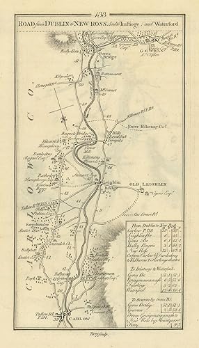
Etat : Good. #134 From Dublin to New Ross. Graiguenamanagh Borris. TAYLOR/SKINNER 1778 map. Antique copperplate road map; George Taylor & Andrew Skinner (1778). 23.0 x 13.0cm, 9 x 5 inches. Condition: Good. There is another map printed on the reverse side: #133 Road from Dublin to New Ross and to Inistioge and Waterford which includes the towns of Goresbridge, Gowran, Leighlinbridge, Old Leighlin, Carlow and covers part of the counties of Carlow, Kilkenny. The map includes the towns of New Ross, Graiguenamanagh, Borris and covers part of the counties of Carlow, Kilkenny, Wexford.
-
Etat : Good. #133 Dublin to Waterford. Carlow Gowran Leighlinbridge. TAYLOR/SKINNER 1778 map. Antique copperplate road map; George Taylor & Andrew Skinner (1778). 23.0 x 13.0cm, 9 x 5.25 inches. Condition: Good. There is another map printed on the reverse side: #134 Road from Dublin to New Ross [and to Inistioge and Waterford] which includes the towns of New Ross, Graiguenamanagh, Borris and covers part of the counties of Carlow, Kilkenny, Wexford. The map includes the towns of Goresbridge, Gowran, Leighlinbridge, Old Leighlin, Carlow and covers part of the counties of Carlow, Kilkenny.
-
Etat : Good. #63 To Sligo by Longford. Edgeworthstown Newtownforbes. TAYLOR/SKINNER 1778 map. Antique copperplate road map; George Taylor & Andrew Skinner (1778). 23.0 x 13.0cm, 9 x 5.25 inches. Condition: Good. There is another map printed on the reverse side: #64 [Road] from Dublin [to Sligo by Longford] which includes the towns of Carrick-on-Shannon, Drumsna, Boyle, Ballinafad, Jamestown and covers part of the counties of Leitrim, Sligo, Roscommon. The map includes the towns of Edgeworthstown, Roosky, Newtownforbes, Longford, Ballinalack, Dromod and covers part of the counties of Longford, Leitrim, Westmeath, Roscommon.
-
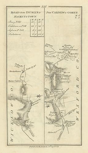
Etat : Good. #145 Dublin to Clonegall & Carnew. Aughrim Rathdrum. TAYLOR/SKINNER 1778 map. Antique copperplate road map; George Taylor & Andrew Skinner (1778). 23.0 x 13.0cm, 9 x 5 inches. Condition: Good. There is another map printed on the reverse side: #146 Road from Dublin to Hacketstown // from Carnew to Gorey which includes the towns of Hacketstown, Gorey, Carnew and covers part of the counties of Wicklow, Wexford, Carlow. The map includes the towns of Clonegall, Aughrim, Shillelagh, Carnew, Tinahely, Rathdrum and covers part of the counties of Wicklow, Galway, Carlow.
-
Etat : Good. #146 Dublin to Hacketstown / Carnew to Gorey. Wicklow. TAYLOR/SKINNER 1778 map. Antique copperplate road map; George Taylor & Andrew Skinner (1778). 23.0 x 13.0cm, 9 x 5.25 inches. Condition: Good. There is another map printed on the reverse side: #145 Road from Dublin to Clonegall & Carnew which includes the towns of Clonegall, Aughrim, Shillelagh, Carnew, Tinahely, Rathdrum and covers part of the counties of Wicklow, Galway, Carlow. The map includes the towns of Hacketstown, Gorey, Carnew and covers part of the counties of Wicklow, Wexford, Carlow.
-
Etat : Good. #64 Carrick/Shannon Drumsna Boyle Ballinafad Jamestown. TAYLOR/SKINNER 1778 map. Antique copperplate road map; George Taylor & Andrew Skinner (1778). 23.0 x 13.0cm, 9 x 5 inches. Condition: Good. There is another map printed on the reverse side: #63 [Road from Dublin] to Sligo by Longford which includes the towns of Edgeworthstown, Roosky, Newtownforbes, Longford, Ballinalack, Dromod and covers part of the counties of Longford, Leitrim, Westmeath, Roscommon. The map includes the towns of Carrick-on-Shannon, Drumsna, Boyle, Ballinafad, Jamestown and covers part of the counties of Leitrim, Sligo, Roscommon.
-
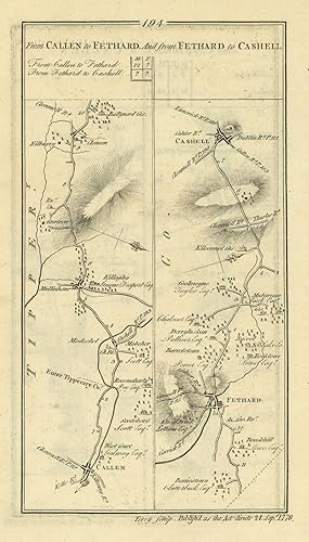
Etat : Good. #194 Callen to Fethard & Cashel. Callan Tipperary. TAYLOR/SKINNER 1778 old map. Antique copperplate road map; George Taylor & Andrew Skinner (1778). 23.0 x 13.0cm, 9 x 5 inches. Condition: Good. There is another map printed on the reverse side: #193 From Cashell to Callen which includes the towns of Killenaule, Callan, Cashel and covers part of the counties of Tipperary, Kilkenny. The map includes the towns of Cashel, Fethard, Callan and covers part of the counties of Tipperary, Kilkenny.
-
Etat : Good. #97 Dublin to Limerick. Portlaoise Roscrea Mountrath. TAYLOR/SKINNER 1778 map. Antique copperplate road map; George Taylor & Andrew Skinner (1778). 23.0 x 13.0cm, 9 x 5 inches. Condition: Good. There is another map printed on the reverse side: #98 Road from Dublin [to Limerick] which includes the towns of Kilcormac, Toomevara, Nenagh, Silvermines and covers part of the counties of Tipperary, Offaly. The map includes the towns of Portlaoise, Borris-in-Ossory, Roscrea, Mountrath and covers part of the counties of Laois, Tipperary.
-
[From Clonmell to Thurles, Nenagh and Birr and to Templemore] // from Birr to Burris-A-Kane
Date d'édition : 1778
Carte
Etat : Good. #192 To Templemore/Birr to Borrisokane. Tipperary Offaly TAYLOR/SKINNER 1778 map. Antique copperplate road map; George Taylor & Andrew Skinner (1778). 23.0 x 13.0cm, 9 x 5 inches. Condition: Good. There is another map printed on the reverse side: #191 From Clonmell to Thurles, Nenagh & Birr [& to Templemore] which includes the towns of Borrisoleigh, Nenagh and covers part of the county of Tipperary. The map includes the towns of Templemore, Birr, Borrisokane and covers part of the counties of Tipperary, Offaly.
-
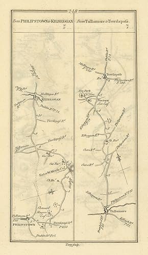
Etat : Good. #248 Daingean to Kilbeggan. Tullamore to Tyrrellspass. TAYLOR/SKINNER 1778 map. Antique copperplate road map; George Taylor & Andrew Skinner (1778). 23.0 x 13.0cm, 9 x 5.25 inches. Condition: Good. There is another map printed on the reverse side: #247 From Trim to Philipstown which includes the towns of Trim, Daingean and covers part of the counties of Offaly, Meath. The map includes the towns of Tyrrellspass, Kilbeggan, Tullamore, Daingean and covers part of the counties of Offaly, Westmeath.
-
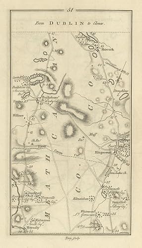
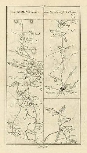
Etat : Good. #51 Dublin to Clones. Bailieborough Kingscourt Moynalty. TAYLOR/SKINNER 1778 map. Antique copperplate road map; George Taylor & Andrew Skinner (1778). 23.0 x 13.0cm, 9 x 5 inches. Condition: Good. There is another map printed on the reverse side: #52 From Dublin to Clones // from Carrickmacross to Shircock which includes the towns of Drum, Cootehill, Carrickmacross, Clones, Shercock and covers part of the counties of Monaghan, Cavan. The map includes the towns of Bailieborough, Kingscourt, Moynalty, Shercock and covers part of the counties of Cavan, Meath.
-
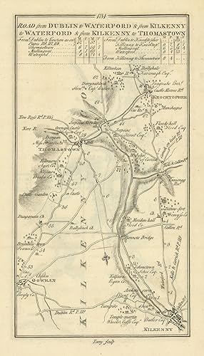
Road from Dublin to Waterford & from Kilkenny to Waterford and from Kilkenny to Thomastown
Date d'édition : 1778
Carte
Etat : Good. #131 Kilkenny to Thomastown. Knocktopher Gowran. TAYLOR/SKINNER 1778 old map. Antique copperplate road map; George Taylor & Andrew Skinner (1778). 23.0 x 13.0cm, 9 x 5.25 inches. Condition: Good. There is another map printed on the reverse side: #132 [Road] from Dublin to Waterford [& from Kilkenny to Waterford and from Kilkenny to Thomastown] which includes the towns of Waterford, Kilmacow, Newmarket, Knocktopher and covers part of the counties of Kilkenny, Waterford. The map includes the towns of Knocktopher, Thomastown, Gowran, Kilkenny and covers part of the county of Kilkenny.
-
Etat : Good. #52 to Clones. Carrickmacross to Shercock. Cootehill. TAYLOR/SKINNER 1778 map. Antique copperplate road map; George Taylor & Andrew Skinner (1778). 23.0 x 13.0cm, 9 x 5 inches. Condition: Good. There is another map printed on the reverse side: #51 From Dublin to Clones which includes the towns of Bailieborough, Kingscourt, Moynalty, Shercock and covers part of the counties of Cavan, Meath. The map includes the towns of Drum, Cootehill, Carrickmacross, Clones, Shercock and covers part of the counties of Monaghan, Cavan.
-
[Road] from Dublin to Waterford [& from Kilkenny to Waterford and from Kilkenny to Thomastown]
Date d'édition : 1778
Carte
Etat : Good. #132 Dublin to Waterford. Kilmacow Newmarket Knocktopher TAYLOR/SKINNER 1778 map. Antique copperplate road map; George Taylor & Andrew Skinner (1778). 23.0 x 13.0cm, 9 x 5.25 inches. Condition: Good. There is another map printed on the reverse side: #131 Road from Dublin to Waterford & from Kilkenny to Waterford and from Kilkenny to Thomastown which includes the towns of Knocktopher, Thomastown, Gowran, Kilkenny and covers part of the county of Kilkenny. The map includes the towns of Waterford, Kilmacow, Newmarket, Knocktopher and covers part of the counties of Kilkenny, Waterford.
-
Etat : Good. #242 Athlone to Roscommon. Longford to Lanesborough. TAYLOR/SKINNER 1778 map. Antique copperplate road map; George Taylor & Andrew Skinner (1778). 23.0 x 13.0cm, 9 x 5 inches. Condition: Good. There is another map printed on the reverse side: #241 From Athlone to Longford which includes the towns of Longford, Athlone, Ballymahon and covers part of the counties of Longford, Westmeath. The map includes the towns of Athlone, Roscommon, Lanesborough, Longford and covers part of the counties of Longford, Roscommon, Westmeath.
-
Etat : Good. #247 From Trim to Philipstown. Daingean Offaly Meath. TAYLOR/SKINNER 1778 map. Antique copperplate road map; George Taylor & Andrew Skinner (1778). 23.0 x 13.0cm, 9 x 5.25 inches. Condition: Good. There is another map printed on the reverse side: #248 From Philipstown to Kilbeggan // from Tullamore to Terrilspass which includes the towns of Tyrrellspass, Kilbeggan, Tullamore, Daingean and covers part of the counties of Offaly, Westmeath. The map includes the towns of Trim, Daingean and covers part of the counties of Offaly, Meath.
-
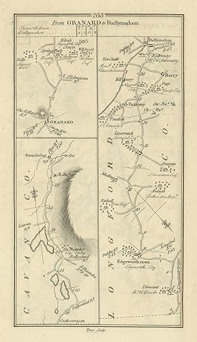
Etat : Good. #233 Granard to Ballymahon. Taghshinny Edgeworthstown. TAYLOR/SKINNER 1778 map. Antique copperplate road map; George Taylor & Andrew Skinner (1778). 23.0 x 13.0cm, 9 x 5.25 inches. Condition: Good. There is another map printed on the reverse side: #234 From Carrick to Ballyshannon, from Manor Hamilton to Coloony which includes the towns of Manorhamilton, Ballintra, Leitrim, Carrick-on-Shannon and covers part of the counties of Leitrim, Donegal. The map includes the towns of Ballymahon, Granard, Barry, Taghshinny, Swanlinbar, Edgeworthstown and covers part of the counties of Longford, Cavan.
-
Etat : Good. #191 Clonmell to Thurles, Nenagh & Birr. Borrisoleigh. TAYLOR/SKINNER 1778 map. Antique copperplate road map; George Taylor & Andrew Skinner (1778). 23.0 x 13.0cm, 9 x 5 inches. Condition: Good. There is another map printed on the reverse side: #192 [From Clonmell to Thurles, Nenagh and Birr and to Templemore] // from Birr to Burris-A-Kane which includes the towns of Templemore, Birr, Borrisokane and covers part of the counties of Tipperary, Offaly. The map includes the towns of Borrisoleigh, Nenagh and covers part of the county of Tipperary.
-
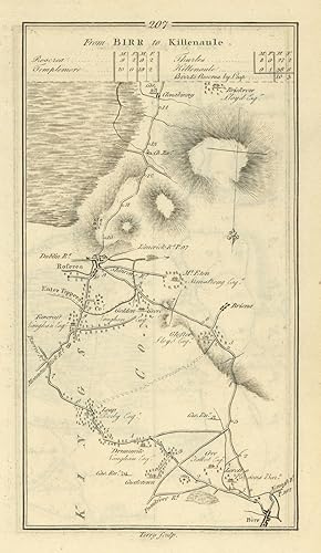
Etat : Good. #207 From Birr to Killenaule. Roscrea Offaly Tipperary. TAYLOR/SKINNER 1778 map. Antique copperplate road map; George Taylor & Andrew Skinner (1778). 23.0 x 13.0cm, 9 x 5.25 inches. Condition: Good. There is another map printed on the reverse side: #208 From Birr to Killenaule which includes the towns of Killenaule, Thurles and covers part of the county of Tipperary. The map includes the towns of Roscrea, Birr and covers part of the counties of Offaly, Tipperary.
-
Etat : Good. #208 From Birr to Killenaule. Thurles Tipperary. TAYLOR/SKINNER 1778 old map. Antique copperplate road map; George Taylor & Andrew Skinner (1778). 23.0 x 13.0cm, 9 x 5 inches. Condition: Good. There is another map printed on the reverse side: #207 From Birr to Killenaule which includes the towns of Roscrea, Birr and covers part of the counties of Offaly, Tipperary. The map includes the towns of Killenaule, Thurles and covers part of the county of Tipperary.
-
Etat : Good. #98 Dublin to Limerick. Toomevara Nenagh Silvermines. TAYLOR/SKINNER 1778 map. Antique copperplate road map; George Taylor & Andrew Skinner (1778). 23.0 x 13.0cm, 9 x 5 inches. Condition: Good. There is another map printed on the reverse side: #97 [Road from Dublin] to Limerick which includes the towns of Portlaoise, Borris-in-Ossory, Roscrea, Mountrath and covers part of the counties of Laois, Tipperary. The map includes the towns of Kilcormac, Toomevara, Nenagh, Silvermines and covers part of the counties of Tipperary, Offaly.
-
Etat : Good. #111 Dublin to Tipperary. Thurles Urlingford Johnstown. TAYLOR/SKINNER 1778 map. Antique copperplate road map; George Taylor & Andrew Skinner (1778). 23.0 x 13.0cm, 9 x 5 inches. Condition: Good. There is another map printed on the reverse side: #112 [Road] from Dublin to [Tipperary & Kilworth] which includes the towns of Golden, Cashel and covers part of the county of Tipperary. The map includes the towns of Thurles, Urlingford, Johnstown and covers part of the counties of Kilkenny, Tipperary.
-
Etat : Good. #119 Dublin to Carrick. Callan Kilkenny Gowran Kells. TAYLOR/SKINNER 1778 map. Antique copperplate road map; George Taylor & Andrew Skinner (1778). 22.5 x 13.0cm, 9 x 5.25 inches. Condition: Good. There is another map printed on the reverse side: #120 [Road] from Dublin [to Cork and from Clonmell to Carrick On Suire] which includes the towns of Carrick-on-Suir, Killamery and covers part of the counties of Kilkenny, Tipperary. The map includes the towns of Callan, Kilkenny, Irishtown, Gowran, Kells and covers part of the counties of Kilkenny, Meath.

![Image du vendeur pour [Road from Dublin to Killala to Roscommon by Lanesboro & to Boyle by Strokestown] from Dublin to. page 71 Shows the Road to Boyle mis en vente par Antiqua Print Gallery](https://pictures.abebooks.com/inventory/md/md31423938178.jpg)
![Image du vendeur pour [Road] from Dublin to Killala [to Roscommon by Lanesboro & to Boyle by Strokestown] mis en vente par Antiqua Print Gallery](https://pictures.abebooks.com/inventory/md/md31423938913.jpg)
![Image du vendeur pour Road from Dublin to New Ross [and to Inistioge and Waterford] mis en vente par Antiqua Print Gallery](https://pictures.abebooks.com/inventory/md/md31423933531.jpg)
![Image du vendeur pour [Road from Dublin] to Sligo by Longford mis en vente par Antiqua Print Gallery](https://pictures.abebooks.com/inventory/md/md31423935280.jpg)

![Image du vendeur pour [Road] from Dublin [to Sligo by Longford] mis en vente par Antiqua Print Gallery](https://pictures.abebooks.com/inventory/md/md31423937191.jpg)
![Image du vendeur pour [Road from Dublin] to Limerick mis en vente par Antiqua Print Gallery](https://pictures.abebooks.com/inventory/md/md31423929750.jpg)
![Image du vendeur pour [From Clonmell to Thurles, Nenagh and Birr and to Templemore] // from Birr to Burris-A-Kane mis en vente par Antiqua Print Gallery](https://pictures.abebooks.com/inventory/md/md31423932588.jpg)
![Image du vendeur pour [Road] from Dublin to Waterford [& from Kilkenny to Waterford and from Kilkenny to Thomastown] mis en vente par Antiqua Print Gallery](https://pictures.abebooks.com/inventory/md/md31423934350.jpg)


![Image du vendeur pour From Clonmell to Thurles, Nenagh & Birr [& to Templemore] mis en vente par Antiqua Print Gallery](https://pictures.abebooks.com/inventory/md/md31423936284.jpg)

![Image du vendeur pour Road from Dublin [to Limerick] mis en vente par Antiqua Print Gallery](https://pictures.abebooks.com/inventory/md/md31423937199.jpg)
![Image du vendeur pour [Road from Dublin to Tipperary] & Kilworth mis en vente par Antiqua Print Gallery](https://pictures.abebooks.com/inventory/md/md31423937201.jpg)
![Image du vendeur pour [Road from Dublin to Cork] & from Dublin to Carrick On Suire mis en vente par Antiqua Print Gallery](https://pictures.abebooks.com/inventory/md/md31423937205.jpg)