Montant total (1 article articles) :
Destination de la commande :

THE WEEKLY DISPATCH WELLER, E (7 résultats)
Passer aux résultats principaux de la recherche
Type d'article
- Tous les types d'articles
- Livres
- Magazines & Périodiques
- Bandes dessinées
- Partitions de musique
- Art, Affiches et Gravures
- Photographies
- Cartes (7)
-
Manuscrits &
Papiers anciens
Etat
- Tous
- Neuf
- Ancien ou d'occasion
Reliure
- Toutes
- Couverture rigide
- Couverture souple
Particularités
- Edition originale
- Signé
- Jaquette
- Avec images
- Sans impression ŕ la demande
Pays
Evaluation du vendeur
-
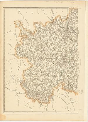
Shropshire.
Edité par LondonThe Weekly Dispatch. July10th and November 15th 1863, 1859
Vendeur : Robert Frew Ltd. ABA ILAB, London, Royaume-Uni
Membre d'association : ABA ILAB PBFA
Evaluation du vendeur :

Carte
Each section c. 30 x 42.5 cm. Original outline colour. Lithograph map printed over two sheets (not joined). Publisher's date stamps to margins. Publisher's descriptionspasted onto verso of southern map sheet. Very lightly browned overall, else in very good condition.
-
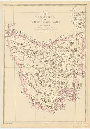
Tasmania or Van Diemen's Land.
Edité par LondonThe Weekly Dispatch. May 19th, 1863
Vendeur : Robert Frew Ltd. ABA ILAB, London, Royaume-Uni
Membre d'association : ABA ILAB PBFA
Evaluation du vendeur :
Carte
43 x 30.1 cm. Original outline colour. Lithograph map.
-
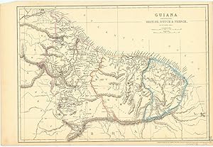
Guiana Comprehending British, Dutch & French.
Edité par LondonThe Weekly Dispatch. May 12th, 1863
Vendeur : Robert Frew Ltd. ABA ILAB, London, Royaume-Uni
Membre d'association : ABA ILAB PBFA
Evaluation du vendeur :
Carte
30.3 x 42.7 cm. Original outline colour. Lithograph map of Guyana, Surinam and French Guiana. Very good condition.
-
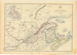
Lower Canada. New Brunswick, Nova Scotia.&c.
Edité par London The Weekly Dispatch. Augt. 5th 1863, 1860
Vendeur : Robert Frew Ltd. ABA ILAB, London, Royaume-Uni
Membre d'association : ABA ILAB PBFA
Evaluation du vendeur :
Carte
30.4 x 42.9 cm. Original outline colour. Lithograph map of south eastern Canada, with inset map of Newfoundland to upper left corner. Publisher's descriptions pasted onto verso. Publisher's date stamp to lower right corner. Some very faint soiling to lower margin, though overall in very good good condition.
-
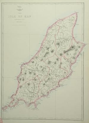
The Isle of Man.
Edité par LondonThe Weekly Dispatch. December 25th 1863, 1860
Vendeur : Robert Frew Ltd. ABA ILAB, London, Royaume-Uni
Membre d'association : ABA ILAB PBFA
Evaluation du vendeur :
Carte
42.5 x 30 cm. Original outline colour. Lithograph map. Publisher's date stamp to lower left margin. Small tear with very small loss at lower left margin by date stamp, otherwise in very good condition.
-
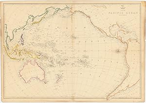
The Pacific Ocean.
Edité par LondonThe Weekly Dispatch. Septr 11th 1863, 1859
Vendeur : Robert Frew Ltd. ABA ILAB, London, Royaume-Uni
Membre d'association : ABA ILAB PBFA
Evaluation du vendeur :
Carte
45 x 64.5 cm. Original outline colour. Double page lithograph map. Date stamp to upper right corner. A few spots across sheet. Some minor creases.
-
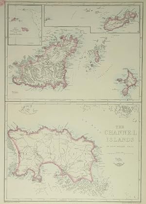
The Channel Islands.
Edité par LondonThe Weekly Dispatch. Octr. 14th 1863, 1860
Vendeur : Robert Frew Ltd. ABA ILAB, London, Royaume-Uni
Membre d'association : ABA ILAB PBFA
Evaluation du vendeur :
Carte
43.6 x 29.9 cm. Original outline colour. Lithograph map of the Channel Islands. The map divided into two main panels, Guernsey and Sark to the upper and Jersey to the lower. Inset maps of Alderney and an index map of all the islands to the upper edge if image. Publisher's date stamp to upper left margin. Small tear without loss to lower left margin, otherwise in good condition.