Montant total (1 article articles) :
Destination de la commande :

UNDERWRITERS SURVEY BUREAU LIMITED (37 résultats)
Passer aux résultats principaux de la recherche
Type d'article
- Tous les types d'articles
- Livres (36)
- Magazines & Périodiques
- Bandes dessinées
- Partitions de musique
- Art, Affiches et Gravures
- Photographies
- Cartes (1)
-
Manuscrits &
Papiers anciens
Etat
- Tous
- Neuf
- Ancien ou d'occasion
Reliure
- Toutes
- Couverture rigide (14)
- Couverture souple
Particularités
- Edition originale
- Signé
- Jaquette
- Avec images (4)
- Sans impression ŕ la demande
Pays
Evaluation du vendeur
-
Insurance Plan of Glencoe, Ontario
Edité par Toronto & Montreal, 1930
Vendeur : Attic Books (ABAC, ILAB), London, ON, Canada
Membre d'association : ABAC ILAB
Evaluation du vendeur :

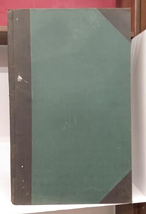
Hardcover. Etat : Good. Form No. 17. 4 linen-backed colour sheets, bound in 57 cm binding, half black cloth with green cloth boards. Stains and rubbing to exterior. Corners bumped, spine ends worn and spine worn and stained. Label inside front cover states the plan was loaned to Mr. Jas. Poole. Poole's name inscribed under town name on first sheet. Foxing and ink stamps to linen. Paper somewhat creased. Plan is from January, 1930 when village population was 779. Shows locations of buildings, railways, exhibition grounds, construction materials, water works, alarm systems, etc.
-

Insurance Plan Of The Town Of Fort St. John, B.C. Population: 5,000 Plan Dated October 1960
Edité par [Toronto]: Underwriters Survey Bureau Limited, 1960., 1960
Vendeur : D & E LAKE LTD. (ABAC/ILAB), Toronto, ON, Canada
Membre d'association : ABAC ILAB
Evaluation du vendeur :

plans measure 13" x 12" (33 x 30 cm). [ff. 1; title]. 7 colour plans on 4 sheets. unbound (small nick & light soiling to title). The plans show commercial and public buildings, schools, churches and private dwellings. Brick, concrete, steel and other types of construction are indicated by colour.
-
Insurance Plan Of The Town Of Kamsack, Sask. Population: 3,000 Plan Dated July 1960
Edité par Toronto: Underwriters Survey Bureau Limited, 1960., 1960
Vendeur : D & E LAKE LTD. (ABAC/ILAB), Toronto, ON, Canada
Membre d'association : ABAC ILAB
Evaluation du vendeur :
plans measure 13" x 12" (33 x 30 cm). [ff. 2; title & index]. 7 colour plans on 4 sheets. unbound (horizontal discolouration to title & last blank page). The plans show commercial and public buildings, schools, churches and private dwellings. Brick, concrete, steel and other types of construction are indicated by colour.
-
Insurance Plan Of The Town Of Cardston, Alta. Population: 2,700 Plan Dated August 1960
Edité par [Toronto]: Underwriters Survey Bureau Limited, 1960., 1960
Vendeur : D & E LAKE LTD. (ABAC/ILAB), Toronto, ON, Canada
Membre d'association : ABAC ILAB
Evaluation du vendeur :
plans measure 13" x 12" (33 x 30 cm). [ff. 2; title & index]. 8 colour plans on 4 sheets. unbound. The plans show commercial and public buildings, schools, hotels, churches and private dwellings. Brick, concrete, steel and other types of construction are indicated by colour.
-
Insurance Plan Of The Town Of Wainwright, Alta. Population: 3,275 Plan Dated August 1960
Edité par [Toronto]: Underwriters Survey Bureau, 1960., 1960
Vendeur : D & E LAKE LTD. (ABAC/ILAB), Toronto, ON, Canada
Membre d'association : ABAC ILAB
Evaluation du vendeur :
plans measure 13" x 12" (33 x 30 cm). [ff. 2; title & index]. 8 colour plans on 4 sheets. unbound (horizontal 1 ˝" discolouration to title & last map). The plans show commercial and public buildings, schools, hotels, churches, private dwellings and the Canadian National Railway Line. Brick, concrete, steel and other types of construction are indicated by colour.
-
Insurance Plan Of The Town Of Bridgetown, N.S. Population: 1,041 Plan Dated June 1962
Edité par [Toronto]: Underwriters Survey Bureau Limited, 1962., 1962
Vendeur : D & E LAKE LTD. (ABAC/ILAB), Toronto, ON, Canada
Membre d'association : ABAC ILAB
Evaluation du vendeur :
plans measure 13" x 12" (33 x 30 cm). [ff. 1; title & index]. 8 colour plans on 4 sheets. unbound. The plans show commercial and public buildings, schools, churches, private dwellings and the Dominion Atlantic Railway line. Brick, concrete, steel and other types of construction are indicated by colour.
-
Insurance Plan Of The Town Of Boucherville, Que. Population 8,650 Plan Dated September 1962
Edité par Toronto: Underwriters Survey Bureau, Ltd., 1962., 1962
Vendeur : D & E LAKE LTD. (ABAC/ILAB), Toronto, ON, Canada
Membre d'association : ABAC ILAB
Evaluation du vendeur :
plans measure 13" x 12" (33 x 30 cm). [ff. 2; title & index]. 9 colour plans on 5 sheets. unbound. The Underwriters Survey Bureau Limited was the official successors to the Chas. E. Goad Company; the business was sold by Goad s sons after their father s death. The plans show commercial and public buildings, schools, churches, apartments, private dwellings, railway lines and the St. Lawrence River.
-
Insurance Plan Of The Town Of Berthierville Que., Population 3683 Plan Dated June, 1953
Edité par Toronto & Montreal: Underwriters Survey Bureau Limited, 1953., 1953
Vendeur : D & E LAKE LTD. (ABAC/ILAB), Toronto, ON, Canada
Membre d'association : ABAC ILAB
Evaluation du vendeur :
plans measure 13" x 12" (33 x 30 cm). 9 colour plans on 5 sheets. unbound (first map bit browned). The Underwriters Survey Bureau Limited was the official successors to the Chas. E. Goad Company; the business was sold by Goad s sons after their father s death. The plans show commercial (Eddy Match Co. Limited) and public buildings, schools, churches, private dwellings, the Bayonne River and Highway No. 2.
-
Insurance Plan Of The Town Of Kapuskasing, Ontario Population: 5,000 Plan Dated June, 1953
Edité par Toronto & Montreal: Underwriters Survey Bureau Limited, 1953., 1953
Vendeur : D & E LAKE LTD. (ABAC/ILAB), Toronto, ON, Canada
Membre d'association : ABAC ILAB
Evaluation du vendeur :
[ff. 1; title & index]. plans measure 13" x 12" (33 x 30 cm). 10 colour plans on 5 leaves (2 folding). unbound (staining & abrasions to upper title area). The Underwriters Survey Bureau Limited was the official successors to the Chas. E. Goad Company; the business was sold by Goad s sons after their father s death. The plans show commercial and public buildings, schools, churches, apartments, private dwellings, railway lines and the Kapuskasing River. Brick, frame, steel and other types of construction are indicated by colour. Spruce Falls Power & Paper Co. Ltd. is shown in detail on plans 8 and 9.
-
Insurance Plan Of The Town Of Fort Macleod, Alta. Population: 2,398 Plan Dated August 1960
Edité par [Toronto]: Underwriters Survey Bureau Limited, 1960., 1960
Vendeur : D & E LAKE LTD. (ABAC/ILAB), Toronto, ON, Canada
Membre d'association : ABAC ILAB
Evaluation du vendeur :
plans measure 13" x 12" (33 x 30 cm). [ff. 3; title & index]. 11 colour plans on 6 sheets. unbound (horizontal 1 ˝" discolouration to title). The plans show commercial and public buildings, schools, hotels, churches, private dwellings, Canadian Pacific Railway Line and Highway No. 2. Brick, concrete, steel and other types of construction are indicated by colour.
-
Insurance Plan Of The Town Of Parrsboro, N.S. Population: 1850 Plan Dated June 1962
Edité par [Toronto]: Underwriters Survey Bureau Limited, 1962., 1962
Vendeur : D & E LAKE LTD. (ABAC/ILAB), Toronto, ON, Canada
Membre d'association : ABAC ILAB
Evaluation du vendeur :
plans measure 13" x 12" (33 x 30 cm). [ff. 1; title & index]. 11 colour plans on 6 sheets. unbound (index tab to edge of title). The plans show commercial and public buildings, schools, churches, private dwellings and the Parrsboro River. Brick, concrete, steel and other types of construction are indicated by colour.
-
Insurance Plan Of The Town Of Lacombe, Alta. Population: 3,000 Plan Dated August 1960
Edité par [Toronto]: Underwriters Survey Bureau Limited, 1960., 1960
Vendeur : D & E LAKE LTD. (ABAC/ILAB), Toronto, ON, Canada
Membre d'association : ABAC ILAB
Evaluation du vendeur :
plans measure 13" x 12" (33 x 30 cm). [ff. 2; title & index]. 11 colour plans on 6 sheets. unbound (horizontal 1 ˝" discolouration to title & last map & stain to title). The plans show commercial and public buildings, schools, hotels, churches, private dwellings, the Calgary & Edmonton Trail and the Canadian Pacific Railway Line. Brick, concrete, steel and other types of construction are indicated by colour.
-
Insurance Plan Of The Town Of Ponoka, Alta. Population: 4,179 Plan Dated August 1960
Edité par [Toronto]: Underwriters Survey Bureau, 1960., 1960
Vendeur : D & E LAKE LTD. (ABAC/ILAB), Toronto, ON, Canada
Membre d'association : ABAC ILAB
Evaluation du vendeur :
plans measure 13" x 12" (33 x 30 cm). [ff. 2; title & index]. 11 colour plans on 6 sheets. unbound (horizontal 1 ˝" discolouration to title). The plans show commercial and public buildings, schools, hotels, churches, private dwellings, the Battle River, Highway No. 2 and the Provincial Mental Hospital. Brick, concrete, steel and other types of construction are indicated by colour.
-
Insurance Plan of Thamesville, Ontario
Edité par Toronto & Montreal, 1925
Vendeur : Attic Books (ABAC, ILAB), London, ON, Canada
Membre d'association : ABAC ILAB
Evaluation du vendeur :
Hardcover. Etat : Very good. Form No. 17. 3 linen-backed colour sheets, bound in 57 cm binding, half black cloth with green cloth boards. Some stains to exterior. Corners bumped and there is light wear to extremities. Label inside front cover states the plan was loaned to Mr. Lea Smith. Foxing and ink stamps to linen. Paper is clean and neat. Scuff on sheet 2 affecting a street name slightly. Plan is from January, 1925 when village population was 900. Shows locations of buildings, railways, creeks, construction materials, water works, alarm systems, etc.
-
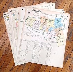
Insurance Plan of the Town of Dundas, Ont., July 1951
Edité par Toronto, 1951
Vendeur : Attic Books (ABAC, ILAB), London, ON, Canada
Membre d'association : ABAC ILAB
Evaluation du vendeur :
Etat : Very good. 13 numbered one-sided 66 cm coloured plans of Dundas, Ontario.
-
Insurance Plan Of The Municipality Of Powell River, B.C. Population: 10, 150 Plan Dated September 1961
Edité par [Toronto]: Underwriters Survey Bureau Limited, 1961., 1961
Vendeur : D & E LAKE LTD. (ABAC/ILAB), Toronto, ON, Canada
Membre d'association : ABAC ILAB
Evaluation du vendeur :
plans measure 13" x 12" (33 x 30 cm). [ff. 3; title & index]. 13 colour plans, numbered 1-1, 1-2 & 5-13 on 9 sheets (2 double page & 1 folding). unbound (creasing to upper corners). The plans show commercial and public buildings, schools, churches and private dwellings. Brick, concrete, steel and other types of construction are indicated by colour.
-
Insurance Plan Of The Town Of Shelburne, N.S. Population: 2,400 Plan Dated June 1962
Edité par [Toronto]: Underwriters Survey Bureau Limited, 1962., 1962
Vendeur : D & E LAKE LTD. (ABAC/ILAB), Toronto, ON, Canada
Membre d'association : ABAC ILAB
Evaluation du vendeur :
plans measure 13" x 12" (33 x 30 cm). [ff. 1; title & index]. 14 colour plans on 7 sheets. unbound. The plans show commercial and public buildings, schools, churches, private dwellings and the Shelburne Harbour. Brick, concrete, steel and other types of construction are indicated by colour.
-
Insurance Plan Of The Town Of Nicolet, Que. Population: 5,300 Plan Dated September, 1954
Edité par Toronto Montreal: Underwriters Survey Bureau, 1954., 1954
Vendeur : D & E LAKE LTD. (ABAC/ILAB), Toronto, ON, Canada
Membre d'association : ABAC ILAB
Evaluation du vendeur :
plans measure 13" x 12" (33 x 30 cm). [ff. 1; title]. 14 colour plans on 7 sheets. unbound (few soil marks to title). The plans show commercial and public buildings, schools, churches, private dwellings, railway lines and the Rivičre Nicolet. Brick, concrete, steel and other types of construction are indicated by colour.
-
Insurance Plan Of The Town Of Richmond Hill, Ont. Population: 15,000.
Edité par Toronto & Montreal: 1960., 1960
Vendeur : D & E LAKE LTD. (ABAC/ILAB), Toronto, ON, Canada
Membre d'association : ABAC ILAB
Evaluation du vendeur :
folio. ff. 3 (title & index), pp. 21 of hand-coloured plans. unbound. The Underwriters Survey Bureau Limited was the official successor to the Chas. E. Goad Company; the business was sold by Goad s sons after their father s death. Issued in 22 volumes from 1952 to 1973, this was the last published insurance plan of the City of Toronto. The plans show commercial and public buildings, schools, apartments and private dwellings. Brick, frame, steel and other types of construction are indicated by colour. Commercial and public buildings have the most detail, including walls, chimneys, roofs, alarm systems, sprinkler systems, storage tanks &c. The village of Richmond Hill was elevated to town status by the Ontario Municipal Board, effective January 1, 1957.
-
Insurance Plan of Alvinston, Ont.
Edité par Underwriters? Survey Bureau Limited, Toronto, 1927
Vendeur : Alexandre Antique Prints, Maps & Books, Toronto, ON, Canada
Membre d'association : ABAC ILAB
Evaluation du vendeur :
Original full cloth boards., Very scarce atlas and insurance plan of the town of Alvingston printed in the early 20th century by the Underwriters? Survey Bureau Limited in fine condition. The Canadian Fire Underwriters' Association was founded in 1883 for the purpose of standardizing fire insurance regulations. Up to the year 1918, the maps were prepared by the Chas. E. Goad map making company and was published by the Canadian Fire Underwriters Association. This agreement ended in 1918, and the Canadian Fire Underwriters' Association started their own mapmaking process and was renamed the Underwriters? Survey Bureau Limited. At the same time they purchased the exclusive rights from the Chas. E. Goad company to revise and reprint their maps. The Goad Company continued to operate until 1930 and in 1931 the Underwriters? Survey Bureau Limited acquired all the assets of the Chas. E. Goad Company. They continued to produce various fire insurance plans for cities and towns in Ontario, Quebec, and the Martimes. Fire insurance plans provide detailed information about buildings and neighbourhoods. They can be used to determine when a building was built or demolished, details of building materials, position of building on lot, lot and address numbers, and lot sizes and shapes. They can show how a neighbourhood has changed over the yearsThe Underwriters' Survey Bureau published individual volumes from the 1920s to the 1940s, and a 1952-73 multi-volume set, covering most of Toronto but concentrating on commercial and industrial districts. The earliest plans cover only the former City of Toronto, while later ones branch out into suburban areas. Not all areas are covered in all years., Size : Folio: 340mm x 540mm, Illustrated with 3 color double page maps depicting various areas of Alvingston in full detail including mainstreets, sidestreets, lots, and also the vulnerability of various buildings prone to fire. All maps are backed on original canvas. A fine copy with very good maps.
-
Markham, Ont.
Edité par Underwriters? Survey Bureau Limited c.1927, Toronto, 1927
Vendeur : Alexandre Antique Prints, Maps & Books, Toronto, ON, Canada
Membre d'association : ABAC ILAB
Evaluation du vendeur :
Carte
Etat : Very Good; A scarce early 20th Century planning of Markham, Ont. , Size : 515x630 (mm), 20.28x24.80 (Inches), Hand Colored.
-
Insurance Plan of Woodbridge Ont.
Edité par Underwriters Survey Bureau Limited, Toronto, 1926
Vendeur : Alexandre Antique Prints, Maps & Books, Toronto, ON, Canada
Membre d'association : ABAC ILAB
Evaluation du vendeur :
Original cloth boards. , Very scarce atlas and insurance plan of the town of Woodbridge printed in the early 20th century by the Underwriters? Survey Bureau Limited in fine condition. The Canadian Fire Underwriters' Association was founded in 1883 for the purpose of standardizing fire insurance regulations. Up to the year 1918, the maps were prepared by the Chas. E. Goad map making company and was published by the Canadian Fire Underwriters Association. This agreement ended in 1918, and the Canadian Fire Underwriters' Association started their own mapmaking process and was renamed the Underwriters? Survey Bureau Limited. At the same time they purchased the exclusive rights from the Chas. E. Goad company to revise and reprint their maps. The Goad Company continued to operate until 1930 and in 1931 the Underwriters? Survey Bureau Limited acquired all the assets of the Chas. E. Goad Company. They continued to produce various fire insurance plans for cities and towns in Ontario, Quebec, and the Martimes. Fire insurance plans provide detailed information about buildings and neighbourhoods. They can be used to determine when a building was built or demolished, details of building materials, position of building on lot, lot and address numbers, and lot sizes and shapes. They can show how a neighbourhood has changed over the yearsThe Underwriters' Survey Bureau published individual volumes from the 1920s to the 1940s, and a 1952-73 multi-volume set, covering most of Toronto but concentrating on commercial and industrial districts. The earliest plans cover only the former City of Toronto, while later ones branch out into suburban areas. Not all areas are covered in all years., Illustrated with 4 color double page maps depicting various areas of Markham in full detail including mainstreets, sidestreets, lots, and also the vulnerability of various buildings prone to fire. Spine is worn, maps are layed down on original canvas, otherwise very good.
-
Insurance Plan Of The City Of Toronto Volume 12 Plan Dated February 1964
Edité par Toronto: Underwriters Survey Bureau Limited, 1964., 1964
Vendeur : D & E LAKE LTD. (ABAC/ILAB), Toronto, ON, Canada
Membre d'association : ABAC ILAB
Evaluation du vendeur :
plans measure 13" x 12" (33 x 30 cm). [pp. 1; title]. 43 colour plans on 25 leaves (1 folding) , numbered 1200 (Key Sheet), 1202-1206, 1209-1214, 1217-1234 & 1236-1249; key sheet does not show plans 1201, 1207, 1208, 1215, 1216 & 1235. unbound. Volume 12 includes plans from the Humber River to St. Clarens Avenue and St. Clair Avenue West to Bloor Street West, including the Junction, Runnymede-Bloor West Village and the Township of York. The Underwriters Survey Bureau Limited was the official successors to the Chas. E. Goad Company; the business was sold by Goad s sons after their father s death. Issued in 22 volumes from 1952 to 1973, this was the last published insurance plan of the City of Toronto. The plans, measuring 13" x 12", were drawn on a scale of 100 feet to one inch. The plans show commercial and public buildings, schools, apartments and private dwellings. Brick, frame, steel and other types of construction are indicated by colour. Commercial and public buildings have the most detail, including walls, chimneys, roofs, alarm systems, sprinkler systems, storage tanks &c.
-
Insurance Plan of Woodbridge Ont.
Edité par Underwriters Survey Bureau Limited, Toronto, 1926
Vendeur : Alexandre Antique Prints, Maps & Books, Toronto, ON, Canada
Membre d'association : ABAC ILAB
Evaluation du vendeur :
Original cloth boards. , The Canadian Fire Underwriters' Association was founded in 1883 for the purpose of standardizing fire insurance regulations. Up to the year 1918, the maps were prepared by the Chas. E. Goad map making company and was published by the Canadian Fire Underwriters Association. This agreement ended in 1918, and the Canadian Fire Underwriters' Association started their own mapmaking process and was renamed the Underwriters? Survey Bureau Limited. At the same time they purchased the exclusive rights from the Chas. E. Goad company to revise and reprint their maps. The Goad Company continued to operate until 1930 and in 1931 the Underwriters? Survey Bureau Limited acquired all the assets of the Chas. E. Goad Company. They continued to produce various fire insurance plans for cities and towns in Ontario, Quebec, and the Martimes. Fire insurance plans provide detailed information about buildings and neighbourhoods. They can be used to determine when a building was built or demolished, details of building materials, position of building on lot, lot and address numbers, and lot sizes and shapes. They can show how a neighbourhood has changed over the yearsThe Underwriters' Survey Bureau published individual volumes from the 1920s to the 1940s, and a 1952-73 multi-volume set, covering most of Toronto but concentrating on commercial and industrial districts. The earliest plans cover only the former City of Toronto, while later ones branch out into suburban areas. Not all areas are covered in all years., Size : Folio 340mm x 550mm , Illustrated with 4 color double page maps depicting various areas of Markham in full detail including mainstreets, sidestreets, lots, and also the vulnerability of various buildings prone to fire. Very scarce atlas and insurance plan of the town of Woodbridge printed in the early 20th century by the Underwriters? Survey Bureau Limited in fine condition.
-
Insurance Plan of Picton, Prince Edward County, Ontario
Edité par Underwriters? Survey Bureau limited c. 1924, Toronto, 1924
Vendeur : Alexandre Antique Prints, Maps & Books, Toronto, ON, Canada
Membre d'association : ABAC ILAB
Evaluation du vendeur :
Original Cloth Boards, Very scarce atlas and insurance plan of the community of Picton printed in the early 20th century by the Underwriters? Survey Bureau Limited in fine condition. The Canadian Fire Underwriters\' Association was founded in 1883 for the purpose of standardizing fire insurance regulations. Up to the year 1918, the maps were prepared by the Chas. E. Goad map making company and was published by the Canadian Fire Underwriters Association. This agreement ended in 1918, and the Canadian Fire Underwriters\' Association started their own mapmaking process and was renamed the Underwriters? Survey Bureau Limited. At the same time they purchased the exclusive rights from the Chas. E. Goad company to revise and reprint their maps. The Goad Company continued to operate until 1930 and in 1931 the Underwriters? Survey Bureau Limited acquired all the assets of the Chas. E. Goad Company. They continued to produce various fire insurance plans for cities and towns in Ontario, Quebec, and the Martimes. Fire insurance plans provide detailed information about buildings and neighbourhoods. They can be used to determine when a building was built or demolished, details of building materials, position of building on lot, lot and address numbers, and lot sizes and shapes. They can show how a neighbourhood has changed over the yearsThe Underwriters\' Survey Bureau published individual volumes from the 1920s to the 1940s, and a 1952-73 multi-volume set, covering most of Toronto but concentrating on commercial and industrial districts. The earliest plans cover only the former City of Toronto, while later ones branch out into suburban areas. Not all areas are covered in all years., Size : Folio: 320 x 545mm , Illustrated with 13 color double page maps depicting various areas of Picton in full detail including mainstreets, sidetreets, lots and also the vulnerability of various buildings prone to fire. The first map depicts Picton in its entirety, while the proceeding 12 maps show sections of the community. The maps also detail the construction and materials used for each building, as well as the hydro, power and security systems in the community. All maps are backed on original canvas. A fine copy in very good condition.
-
Insurance Plan Of The City Of Toronto Volume 9 [Part 2] Sheets 948-1 To 978 January 1956 .
Edité par Toronto & Montreal: Underwriters Survey Bureau Limited, 1956., 1956
Vendeur : D & E LAKE LTD. (ABAC/ILAB), Toronto, ON, Canada
Membre d'association : ABAC ILAB
Evaluation du vendeur :
plans measure 13" x 12" (33 x 30 cm). [pp. 1; title + 1 leaf note]. 64 colour plans on 34 leaves (some folding), numbered 900-901 (key plans) & 948-1 to 978. 7 ring cloth binder (title bit soiled, folding sections of one plan partially detached but present, short tear to outer edge of one plan). Volume 9, Part 2, includes plans from Woodbine Avenue to McCowan Road and St. Clair Avenue to Lake Ontario. The Underwriters Survey Bureau Limited was the official successors to the Chas. E. Goad Company; the business was sold by Goad s sons after their father s death. Issued in 22 volumes from 1952 to 1973, this was the last published insurance plan of the City of Toronto. The plans, measuring 13" x 12", were drawn on a scale of 100 feet to one inch. The plans show commercial and public buildings, schools, apartments and private dwellings. Brick, frame, steel and other types of construction are indicated by colour. Commercial and public buildings have the most detail, including walls, chimneys, roofs, alarm systems, sprinkler systems, storage tanks &c.
-
Insurance Plan Of The City Of Toronto Volume 9 [Part 1] Sheets 900 To 947-3 January 1956
Edité par Toronto & Montreal: Underwriters Survey Bureau Limited, 1956., 1956
Vendeur : D & E LAKE LTD. (ABAC/ILAB), Toronto, ON, Canada
Membre d'association : ABAC ILAB
Evaluation du vendeur :
plans measure 13" x 12" (33 x 30 cm). [pp. 1; title + 1 leaf note]. 64 colour plans on 40 leaves (some folding), numbered 900-901 (key plans) & 902-947-3. 7 ring cloth binder (few folding sections detached & creased with short tears, but present). Volume 9, Part 1, includes fire insurance plans of Toronto East (Beaches and Upper Beaches), East York and Scarborough from Lake Ontario to Eglinton Avenue and Woodbine Avenue to McCowan Road. The Underwriters Survey Bureau Limited was the official successors to the Chas. E. Goad Company; the business was sold by Goad s sons after their father s death. Issued in 22 volumes from 1952 to 1973, this was the last published insurance plan of the City of Toronto. The plans, measuring 13" x 12", were drawn on a scale of 100 feet to one inch. The plans show commercial and public buildings, schools, apartments and private dwellings. Brick, frame, steel and other types of construction are indicated by colour. Commercial and public buildings have the most detail, including walls, chimneys, roofs, alarm systems, sprinkler systems, storage tanks &c.
-
[Insurance Plan Of The City Of Montreal Volume 6].
Edité par [Toronto & Montreal: Underwriters Survey Bureau Limited, 1959, 1954, 1961 & 1972 & [Vol. 11] Toronto: Canadian Underwriters Association, 1964]., 1972
Vendeur : D & E LAKE LTD. (ABAC/ILAB), Toronto, ON, Canada
Membre d'association : ABAC ILAB
Evaluation du vendeur :
plans measure 13" x 12" (33 x 30 cm). 54 colour plans on 27 sheets (not complete), numbered 655-699-10. unbound (light soiling to few plans). [WITH]: CANADIAN UNDERWRITERS ASSOCIATION. Insurance Plan Of The City Of Montreal Volume 11 Partially revised 1964. [pp.1; title]. 1 colour plan from Vol. 11 numbered 1100 (not complete). unbound (staining). [WITH]: UNDERWRITERS SURVEY BUREAU LIMITED. [Insurance Plan Of The City Of Montreal Volume 12]. 7 colour plans on 5 sheets (not complete), numbered 1213-1214, 1248, 1265, 1279, 1284 & 1288 (1 folding). unbound (folding section detached & stapled & few of side binder holes chipped). [WITH]: UNDERWRITERS SURVEY BUREAU LIMITED. [Insurance Plan Of The City Of Montreal Volume 14]. 9 colour plans on 5 sheets (not complete), numbered 1407-1-1407-4, 1408-1-1408-5. unbound (map 1408-5 correction sheet with adhesive backing). [WITH]: UNDERWRITERS SURVEY BUREAU LIMITED. [Insurance Plan Of The City Of Montreal Volume 18]. 1 colour plan from Vol. 18 (not complete) numbered 1817 (verso blank). unbound.
-
Insurance Plan of Oshawa, Ont
Edité par Underwriters' Survey Bureau Limited, Toronto & Montreal, 1948
Vendeur : Minotavros Books, ABAC ILAB, Whitby, ON, Canada
Membre d'association : ABAC ILAB
Evaluation du vendeur :
Hardcover. Etat : Near Fine. No Jacket. 14.5" x 22" Copy No. 87. Green cloth boards, screw post binding, new spine label. Printed on linen-backed paper. 27 ff. folding colour sheets. Recently professionally rebacked, all leaves remounted on new cloth strips. Contains plans for General Motors Canada and Township of East Whitby. Underwriters' Survey Bureau produced plans for Ontario, Quebec, and the Maritimes in limited numbers. Orig cloth boards worn and frayed at edges, scuffed and rubbed. Some foxing to linen, minor marginal damp staining to top and tail edges.
-
Insurance Plan of Midland, Simcoe County, Ont. (Georgian Bay)
Edité par Underwriters? Survey Bureau Limited, Toronto, 1946
Vendeur : Alexandre Antique Prints, Maps & Books, Toronto, ON, Canada
Membre d'association : ABAC ILAB
Evaluation du vendeur :
Original full crimson cloth. , Very scarce atlas and insurance plan of the town of Midland printed in the mid 20th century by the Underwriters? Survey Bureau Limited in fine condition. The Canadian Fire Underwriters' Association was founded in 1883 for the purpose of standardizing fire insurance regulations. Up to the year 1918, the maps were prepared by the Chas. E. Goad map making company and was published by the Canadian Fire Underwriters Association. This agreement ended in 1918, and the Canadian Fire Underwriters' Association started their own mapmaking process and was renamed the Underwriters? Survey Bureau Limited. At the same time they purchased the exclusive rights from the Chas. E. Goad company to revise and reprint their maps. The Goad Company continued to operate until 1930 and in 1931 the Underwriters? Survey Bureau Limited acquired all the assets of the Chas. E. Goad Company. They continued to produce various fire insurance plans for cities and towns in Ontario, Quebec, and the Martimes. Fire insurance plans provide detailed information about buildings and neighbourhoods. They can be used to determine when a building was built or demolished, details of building materials, position of building on lot, lot and address numbers, and lot sizes and shapes. They can show how a neighbourhood has changed over the yearsThe Underwriters' Survey Bureau published individual volumes from the 1920s to the 1940s, and a 1952-73 multi-volume set, covering most of Toronto but concentrating on commercial and industrial districts. The earliest plans cover only the former City of Toronto, while later ones branch out into suburban areas. Not all areas are covered in all years., Size : Folio: (325mm x 550mm), Illustrated with 15 color double page maps depicting various areas of Midland in full detail including mainstreets, sidestreets, lots, and also the vulnerability of various buildings prone to fire. All maps are backed on original canvas. A fine copy with very good maps.