
Montant total (1 article articles) :
Destination de la commande :

VISSCHER, NICHOLAS (26 résultats)
Passer aux résultats principaux de la recherche
Type d'article
- Tous les types d'articles
- Livres (15)
- Magazines & Périodiques
- Bandes dessinées
- Partitions de musique
- Art, Affiches et Gravures (1)
- Photographies
- Cartes (10)
-
Manuscrits &
Papiers anciens
Etat
- Tous
- Neuf
- Ancien ou d'occasion
Reliure
Particularités
- Edition originale
- Signé
- Jaquette (3)
- Avec images (18)
- Sans impression ŕ la demande
Pays
Evaluation du vendeur
-
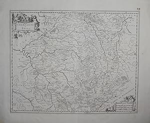
Champaigne et Brie. Map of the region Champagne in France.
Edité par Amsterdam, Visscher ca. 1690., 1690
Carte
Etat : Gut. Size: 39,5 x 49 cm. Sheet: 52 x 62 cm. Sprache: Deutsch Gewicht in Gramm: 2000.
-
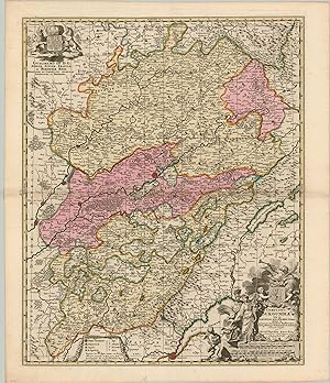
Comitatus Burgundiae Gorgeous map by Visscher showing the Burgundy wine region of France.
Date d'édition : 1685
Vendeur : Curtis Wright Maps, Berwyn, IL, Etats-Unis
Membre d'association : ESA
Evaluation du vendeur :

Etat : Fine. Burgundy is perhaps the most respected wine region in all of France. It has the highest number of appellations d'origine contrôlée (AOC) wines, and terroir plays a critically important role in the delineation of wines, even down to specific vineyards. This dates back to monastic orders, like the Benedictines and Cistercians, that cultivated large swathes of grape vines throughout the region. They noticed different vineyards gave consistently different characteristics to wines, and even began walling in these vineyards to establish firm borders between them. Today, a cru is a vineyard, or group of vineyards, that that shares the same terroir and recognized consistent quality. This system has its foundations in the monastic orders of the 14th century! Sheet Width (in) 20.9 Sheet Height (in) 24.4 Condition Description The map is in near fine condition, with original hand color applied to a bold impression on thick rag paper.
-
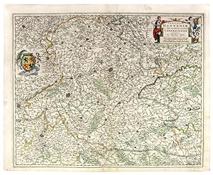
Comitatus Hannonia, et archiepiscopatus cameracensis tabula.
Edité par Amsterdam c., 1680
Vendeur : Shapero Rare Books, London, Royaume-Uni
Membre d'association : ABA ILAB PBFA
Evaluation du vendeur :
Carte
Double-page engraved map, hand-coloured in outline. An immensely detailed and 'compact' map of Hainault - a province of Wallonia, one of the three regions of Belgium by the famous Dutch cartographer, Nicolas Visscher. It borders on the provinces of West Flanders, East Flanders, Flemish Brabant (Flanders) and those of Walloon Brabant and Namur (Wallonia), and on France. In addition to the tremendous wealth of information contained within the map, a regional coat of arms and a decorative title cartouche, add a glorious aesthetic touch. 505 x 610 mm. (20 x 24 inches).
-
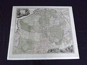
Belgii Pars Meridionalis cum Occidentalibus Germaniae et Septentrionalibus Franciaeâ ¦
Edité par c1690., Amsterdam:, 1690
Vendeur : Nicholas D. Riccio Rare Books, ABAA, Florham Park, NJ, Etats-Unis
Membre d'association : ABAA ILAB
Evaluation du vendeur :

Double page engraved map (24" x 20 1/2"), hand colored, wide margins, decorative title cartouche. A few minor small chips and tears in margins, some fold tears repaired, minor aging; otherwise very good. Nicholas Visscher (1587-1637) started the Visscher map dynasty, which was continued by his son and grandson, also named Nicholas. The family was a dominant force during the golden age of Dutch mapmaking. The present shows Belgium, Luxembourg, part of France and Germany. Van De Gohm p 148.
-
Hollandiae Pars Meridonaliorâ ¦
Edité par c1690., Amsterdam:, 1690
Vendeur : Nicholas D. Riccio Rare Books, ABAA, Florham Park, NJ, Etats-Unis
Membre d'association : ABAA ILAB
Evaluation du vendeur :
Double page engraved map (24 1/2" x 21"), hand colored, wide margins, decorative title cartouche. Some small chips or tears in margins, not affecting image, split repaired in lower margin at centerfold, about 1 1/2", some slight creasing at center of map, normal aging and browning; still a very attractive map with a crisp impression. Nicholas Visscher (1587-1637) started the Visscher map dynasty, which was continued by his son and grandson, also named Nicholas. The family was a dominant force during the golden age of Dutch mapmaking. The present map is of the southern part of Holland, and is illustrated with an attractive title cartouche in the lower left corner. Van De Gohm p 148.
-
Carte Particulire du Terroir et des Environs des Paris qui est la plus Grande partie de l'Isle de France Parfaitement Bien Dessinee
Edité par Amsterdam, 1696
Vendeur : Alexandre Antique Prints, Maps & Books, Toronto, ON, Canada
Membre d'association : ABAC ILAB
Evaluation du vendeur :

Carte
Size : 575x488 (mm), 22.625x19.25 (Inches), Hand Colored Very Good; some light scattered browning.
-
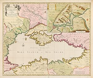
Nouvelle Carte de la Mer Noire et du Canal de Constantinople
Edité par Amsterdam, Elisabeth Visscher, 1710
Carte
No Binding. Etat : Very Good. Engraving, 48.5 x 58 cm, with an inset "Canal de Constantinople" 19 x 28 cm (slight paper fraying at the bottom centerfold). In 1704 Hendrick Doncker published in Amsterdam the "Atlas of the Don" compiled by Admiral of the Russian Navy Cornelius Cruys. The atlas includes a general maps of the Black Sea and a map of the Sea of Azov, which were swiftly reproduced by other cartographers. This particular version was published by Elisabeth Visscher, who continued the map publishing business after the passing of her husband, Nicholas Visscher II. Kordt 1931, XII, Bagrov, PP. 317-22.
-
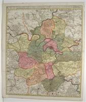
Comitatus Namurci Emendata Delineatio, Nuperrime in lucem.
Edité par Amsterdam: Frederick De Wit, c. 1705., 1705
Vendeur : Arader Galleries - AraderNYC, New York, NY, Etats-Unis
Evaluation du vendeur :
Single sheet, (21 x 24 5/8 inches; 18 x 21 7/8 to the neat line; full margins showing the plate mark). Magnificent engraved map of the province of Namur in Belgium, with ORIGINAL COLOR BY A SKILLED HAND, the individual cities shown in different bold watercolors of pink, green, and yellow and HEIGHTENED WITH LIQUID GOLD, decorated with a fine compass rose pointing north with a GOLD-ENHANCED FLEUR-DE-LIS, surrounded by a border of yellow wash (short marginal tear not affecting image, old central fold, slightly toned). BRILLIANTLY HAND-COLORED map of the province of Namur (Namen) in southeastern Belgium with ELABORATE LIQUID GOLD HIGHLIGHTS. Decorated with TWO STRIKING CARTOUCHES: one flanked by putti and instruments of war above the distance scale, and the other a coat of arms with a cherub. A small compass rose colored in red and green sits near the top of the map within the image. Several fortified cities are illustrated and named, including Huy, Ghiney, Dinant, Bouignes, Fontaine, Charleroy, and Giblou, with notations for churches, castles, forests, and mountains. Originally published by the second Nicholas Visscher, a new edition of this map was later published by his son Nicholas (1649-1709) in his monumental work "Atlas Minor" (1680). Versions were also issued by Peter Schenk and Frederick De Wit in "Atlas Maior" (as here) at the end of the 17th century and subsequently reprinted in various editions. The Visscher family was one of the most distinguished of all 17th-century cartographic firms, and a major player in the era now considered the golden age of Dutch mapmaking. In the late 1600's, a period of great geographical discovery, Amsterdam became an international center of the arts and of cartography, with engravers and printers produced magnificent maps and charts of every kind. The fields of artistic production and mapmaking were arguably more seamlessly united during this era than any period before or since, as the strong competition among publishers meant that maps not only had to be scrupulously accurate, but also visually appealing. In this milieu, a number of venerable firms, including those established by Blaeu, Jansson, Hondius, as well as Visscher, competed for the ever-expanding market for maps and atlases. The firm founded by Nicholas Visscher set standards for exceptional quality that few others were able to equal, and Hendrick de Leth, who eventually rose to assume control of the Visscher publishing house in the 18th century, maintained the company's standards for excellence during a period when Amsterdam's cartographic preeminence was just beginning to be challenged by the French school of scientific cartography.
-
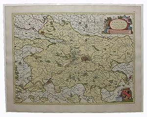
![Image du vendeur pour Exactissima Helvetiae Rhaetiae Valesiae Caeterorumq Confoederatorum ut et finitimorum Popularum [Precise Map of Switzerland, Rhaetia, Valesia and Regions of Neighboring Confederated Nations]. mis en vente par Arader Galleries - AraderNYC](https://pictures.abebooks.com/inventory/md/md15042668484.jpg)
Exactissima Helvetiae Rhaetiae Valesiae Caeterorumq Confoederatorum ut et finitimorum Popularum [Precise Map of Switzerland, Rhaetia, Valesia and Regions of Neighboring Confederated Nations].
Edité par Amsterdam: Frederick De Wit, c. 1705., 1705
Vendeur : Arader Galleries - AraderNYC, New York, NY, Etats-Unis
Evaluation du vendeur :
Single sheet, (21 Ľ x 24 Ľ inches; 18 Ľ x 22 Ľ inches to the neat line; full margins showing the plate mark). Exceptionally fine engraved map of Switzerland with MAGNIFICENT ORIGINAL HAND COLOR IN FULL, with the individual regions shown in different bold watercolors of green, pink, and yellow, the topographical features shown pictorially, HEIGHTENED WITH LIQUID GOLD, the fine compass rose pointing north with a GOLD-ENHANCED FLEUR-DE-LIS, surrounded by a border of yellow wash (separating along old central fold, slightly toned). A beautifully detailed map of Switzerland and surrounding regions in present-day France, Germany, and Italy with EXCEPTIONALLY FINE HAND COLOR HEIGHTENED WITH LIQUID GOLD. This map features two decorative cartouches: the larger is flanked by two putti, one in military garb, and the smaller has one putto and reads "Illustrissimis. Potentissimis ac Florentissimis Rebus-Publicis Helvetiorum, Tigurinae, Bernensi Basiliensi Scaphusinae Novam hanc & postomnes alias Exactissinam Helvetiae Tabulam d. d. d." Originally published by the second Nicholas Visscher, a new edition of this map was later published by his son Nicholas (1649-1709) in his monumental work "Atlas Minor" (1680). Versions were also issued by Peter Schenk and Frederick De Wit in "Atlas Maior" (as here) at the end of the 17th century and subsequently reprinted in various editions. Deftly illustrated with topographical features, in particular the extensive mountain ranges, with hundreds of small villages named. A small compass rose sits below a cherub holding the scale of miles, which shows Swiss, German, Italian, and French measurements. Several cities are noted with a LIQUID GOLD dot: Basel, Schaffhausen, Bern, Geneva, Chur, Worms, Morbegno, Lucerne, Stans, Sion, Chiavenna, Schwyz, Zug, Altdorf, Glarus, Fribourg, and Bergamo. "When pre-modern Switzerland is being compared with other European states it is important to remember that the former was not a centralized monarchy but mainly a confederation of sovereign city-states and peasant republics. Hence there was no truly centralized or mercantilised economic policy. Just as importantly, cottage industries, proto-industrialisation, markets and (to a large extent) foreign trade were directed and controlled by the 'capitals' of the major city-states. The further these 'capitals' were from the centre of Switzerland, the greater their economic dominance. There was a considerable variety of rural-urban relationships between individual city-states. In the secondary and tertiary sector, for example, Basle, Zurich, Schaffhausen and Geneva pursued a consisted economic policy which favoured entrepreneurs and merchants living in the capital. The policies of the old state of Berne, on the other hand, encouraged the economic activities which had developed in the towns and larger rural centres. In the peasant republics and the city-states of central Switzerland, the dominant economic activities of milk and livestock production, mercenary service and the corresponding foreign trade had always been under the control of the socio-politically dominant families in the capital or the rural centres. For banking and exchange facilities, in particular international payment transactions and capital investment, they were wholly dependent on the commercial bankers of Geneva, Lausanne, Berne, Basle and Zurich. In the central region between Geneva and Lake Constance, where proto-industrialisation and the outwork system were solidly established, the division of labour between town and country, still perceptible in the late middle ages and the sixteenth century, became progressively blurred: by the end of the ancien regime, a more or less unified economic area had been created which was able to adapt to the economic liberalism of the nineteenth century with a considerable degree of flexibility" (Epstein, p. 249). The Visscher family was one of the most distinguished of all 17th-century cartographic firms, and a major playe.
-

Generalis Lotharingiae Ducatus Tabula.
Edité par c.1690, Amsterdam, 1690
Vendeur : Alexandre Antique Prints, Maps & Books, Toronto, ON, Canada
Membre d'association : ABAC ILAB
Evaluation du vendeur :
Carte
Etat : Very Good;slightly browned. Size : 470x572 (mm), 18.50x22.52 (Inches), Original Hand Coloring.
-
Champaigne et Brie etc.
Edité par c.1690, Amsterdam, 1690
Vendeur : Alexandre Antique Prints, Maps & Books, Toronto, ON, Canada
Membre d'association : ABAC ILAB
Evaluation du vendeur :
Carte
Etat : Very Good; Size : 403x494 (mm), 15.87x19.45 (Inches), Original Hand Coloring.
-
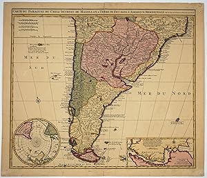
Carte du Paraguay, du Chili, Detroit des Magellan & Terre de Feu , dans l'Amerique Meridionale. Map
Edité par Amsterdam, 1690
Vendeur : Antipodean Books, Maps & Prints, ABAA, Garrison, NY, Etats-Unis
Membre d'association : ABAA ANZAAB ESA ILAB
Evaluation du vendeur :
Handsome map publ. ca. 1690, focusing on South America from around 20? S to 58? S. Copper engraved with stunning full original color, 58.5 x 51cms. 2 insets, one a South Polar Projection (to the equator) which marks "Australia Inaccessa" & "Antarcticus Polus" & includes Australia, New Guinea, S. American and Africa. The other insert is a detailed map of the Straights of Magellan, with text and depth soundings. Very decorative and important early representation of the Cape Horn area. Includes "I. de Roche" (discovered 1675). Includes land to the SW of Cape Horn discovered by Francis Drake and Jacques Le Maire.
-
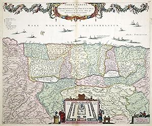
Terra Sancta, sive Promissionis, olim Palestina.
Edité par Amsterdam, 1659. 465 x 565mm (18Ľ x 22Ľ inches)., 1659
Vendeur : Tooley, Adams & Co., Wallingford, OXON, Royaume-Uni
Evaluation du vendeur :
Original body colour; water staining to the margins at the top, some light spotting and darkening of centrefold due too guard paste, otherwise very good. Map of the Holy Land orientated to the west, divided amongg the Tribes on both sides of the River Jordan. The shoreline runs from Sidon to Egypt. The Kishon River connects Haifa Bay to the Lake of Tiberias. Along the top a garland of fruit and flora is held aloft by cherubs. Bottom centre is the encampment of the Tribes in the desert surrounding the Tabernacle and flanked by Moses and Aaron. LAOR: 793.
-
S. Imperium Romano-Germanicum oder Teutschland Mitseinen Angrantzenden Konigreichen Und Provincien.
Edité par Amsterdam, 1680
Vendeur : Alexandre Antique Prints, Maps & Books, Toronto, ON, Canada
Membre d'association : ABAC ILAB
Evaluation du vendeur :
Carte
Etat : Very Good; Size : 472x570 (mm), 18.58x22.44 (Inches), Original Outline Coloring.
-
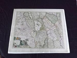
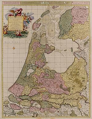
Hollandiae Comitatus in Ejusdem Subjacentes Ditiones: una cum toto ultrjectino dominio, nec non maximus partibus Geldriae Ducatus, Frisiae Comitatus, aliarumq vicinarum provinciarum foederatarum
Edité par Amsterdam, Visscher, [c.]., 1690
Vendeur : Inanna Rare Books Ltd., Skibbereen, CORK, Irlande
Evaluation du vendeur :
Art / Affiche / Gravure
Original hand-coloured engraving. Plate Size: 56 cm x 74.5 cm. Sheet Size: 60.5 cm x 78 cm. Original and rare map. In good+ condition. Some minor tears to margin. A few professional repairs to reverse. Some minor abrasions to map. Aternate title in upper margin:' Landkaart vertonende het Graafschap Holland, seer dienstig om te reysen na en van syne naburige provincien, als mede de Hoven van Soestdyk, 't Loo en Cleef / t' Amsteldam door Nicolaus Visscher met privilegie. Interesting and detailed large map of The Netherlands from Hertogdom Brabant in the south to Friesland in the north. The political subdivisions are also highlighted and the historic placenames, regions and provinces - such as 'T Land Van Utrecht' - are included in Dutch. The map is crowded with topographical detail, showing the location of rivers, hills, towns and the transportation network criss-crossing Holland. The precariousness of Dutch security is evident given the myriad of fortified towns and cities across the map. The sandbanks of the shallow Zuiderzee (De Zuyder Zee) can be seen. Haarlemmer Meer and Leydsche Meer are also identified on the map - much of this was drained and reclaimed in the 19th and 20th centuries. The West Frisian Islands of Texel, Elieland and Der Schelling are also included. A scarce, late 17th Century map of the Dutch Republic as it bathed in the rich, late glow of its Golden Age. The map was published around the period William of Orange, Prince of Orange and Stadtholder of Holland, Zeeland, Utrecht, Guelders and Overijssel in the Dutch Republic became King of England, Ireland and Scotland after the 1689 invasion of England, in what became known as the Glorious Revolution. Large decorative title cartouche, with Classical allusions and the Dutch coat-of-arms lies in the North Sea. Compass rose lies beneath. bar scales and map keys within the borders. Nicolaes Visscher (1618-1679) was a Dutch engraver, cartographer and publisher. He was the son of Claes Janszoon Visscher.His son, Nicolaes Visscher II (1649 1702), also worked with him and continued the family tradition of mapmaking after his death. After the death of Nicolas II, his widow passed the business to Pieter Schenk. His engraved double hemisphere map, Orbis Terrarum Nova et Accuratissima Tabula, was created in 1658 in Amsterdam. It also contains smaller northern and southern polar projections. (Wikipedia).
-
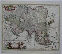
Asiae Nova Delineatio.
Edité par Amsterdam, 1682
Vendeur : Alexandre Antique Prints, Maps & Books, Toronto, ON, Canada
Membre d'association : ABAC ILAB
Evaluation du vendeur :
Carte
Etat : Very Good. A highly decorative map of Asia with a large cartouche in lower left and the Royal Coat of Arms of Holland in the upper left., Size : 442x550 (mm), 17.375x21.625 (Inches), Original Hand Coloring, 0.
-
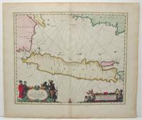
Insulae Iavae Cum parte insularum Borneo Svmatrae et circumjacentium insularum novissima delineatio
Edité par Amsterdam, 1680
Vendeur : Alexandre Antique Prints, Maps & Books, Toronto, ON, Canada
Membre d'association : ABAC ILAB
Evaluation du vendeur :
Carte
Size : 423x515 (mm), 16.625x20.25 (Inches), Original Hand Coloring Very Good; some light age toning.
-
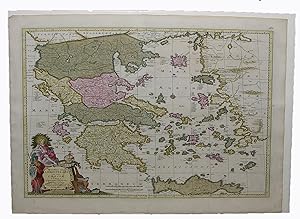
Exactissima totius Archipelagi nec non Graeciae Tabula.
Edité par Amsterdam: Frederick De Wit, [c. 1710]., 1710
Vendeur : Arader Galleries - AraderNYC, New York, NY, Etats-Unis
Evaluation du vendeur :
Single sheet, (21 x 24 ˝ inches). EXTREMELY FINE engraved map of Greece, surrounded by a border of yellow wash, with EXTREMELY FINE ORIGINAL HAND COLOR IN FULL, HEIGHTENED IN LIQUID GOLD, the individual regions shown in different bold watercolors of yellow, green, and pink, decorated with a fine compass rose pointing north with a GOLD-ENHANCED FLEUR-DE-LIS, the title within an ELABORATE HISTORIATED CARTOUCHE (old central fold, slightly toned). An EXTREMELY FINE engraved map of the Greek archipelago, Crete, part of Asia Minor, and the Aegean Sea. The beautiful title cartouche shows two figures, one with a halo painted with LIQUID GOLD and the other in military garb, surrounded by symbols of Greek antiquity, including a lute, armillary sphere, sheet music, and mathematical symbols. The colorist has added a marbling effect to the title panel, adding another layer of texture. The primary regions, indicated by color, are Macedonia, Thelia, Epirus, Livadia Acchaia, Peloponesus Morea, and Creta Candia [Crete]. Other islands shown are Cefalonia, Cyprus, Lesbos, Lemnos, and Chios. The Visscher family was one of the most distinguished of all 17th-century cartographic firms, and a major player in the era now considered the golden age of Dutch mapmaking. In the late 1600's, a period of great geographical discovery, Amsterdam became an international center of the arts and of cartography, with engravers and printers produced magnificent maps and charts of every kind. The fields of artistic production and mapmaking were arguably more seamlessly united during this era than any period before or since, as the strong competition among publishers meant that maps not only had to be scrupulously accurate, but also visually appealing. In this milieu, a number of venerable firms, including those established by Blaeu, Jansson, Hondius, as well as Visscher, competed for the ever-expanding market for maps and atlases. The firm founded by Nicholas Visscher set standards for exceptional quality that few others were able to equal, and Hendrick de Leth, who eventually rose to assume control of the Visscher publishing house in the 18th century, maintained the company's standards for excellence during a period when Amsterdam's cartographic preeminence was just beginning to be challenged by the French school of scientific cartography. Catalogued by Kate Hunter.
-
Carte Nouvelle contenant la partie d'Amerique la Plus Septentrionale ou sont Exactement decrites les Provences suivantes comme le Canada ou Nouvelle France, la Nouvelle Ecosse, La Nouvelle Angleterre, Les Nouveaux Pais Bas, La Pensylvanie, La Virginie, .
Edité par Schenk, Pieter, Amsterdam, 1719
Vendeur : Alexandre Antique Prints, Maps & Books, Toronto, ON, Canada
Membre d'association : ABAC ILAB
Evaluation du vendeur :
Carte
Etat : Very Good. Second State"Published in Atlas Minor Sive Geographica ---, in a number of editions 1717 -1719, Ottens 1729, SMA AIII 97 L4K; SMA AIII 293 VII 1729 L5g. In this state of the map, "Nunc apud Petrum Schenk Junior" is engraved at the bottom of the map."-Kershaw 320, Size : 605x480 (mm), 23.75x18.875 (Inches), Hand Colored, 0.
-
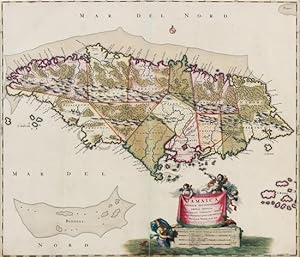
Jamaica, Americae Septentrionalis ampla insula.
Edité par Amsterdam: Nicholas Visscher, [ca. 1680], 1680
Vendeur : Arader Galleries - AraderNYC, New York, NY, Etats-Unis
Evaluation du vendeur :
Unbound. Engraved map of Jamaica with fine contemporary body coloring, cartouche and legend surrounded by putti and a mermaid (Image: 20 1/4 x 23 1/8 in.; 51.5 x 59.3 cm. Sheet: 20 1/2 x 23 Ľ in.; 52 x 60 cm). BINDING/CONDITION: Floated on sturdy card stock and sealed in mylar. Centerfold split neatly mended. (65B1F) A FINE BRIGHT COPY WITH VIVID CONTEMPORARY COLORING. The map shows the island divided into precincts, and depicts mountainous and forested regions. PROVENANCE: Evelyn and Eric P. Newman (sale, Leslie Hindman, 12 November 2018, lot 119).
-
Bavariae Palatinatus Vulgo Die Ober-Pflatz.
Edité par Amsterdam: Visscher, after 1683., 1683
Vendeur : Arader Galleries - AraderNYC, New York, NY, Etats-Unis
Evaluation du vendeur :
"Single sheet (21 x 24 ľ, full margins showing the platemark) (Light browning to margin edge, excellent condition) A stunning engraved Visscher map depicting Bavaria; and hand-colored by the celebrated Master Colorist DIRK JANSZ. VAN SANTEN. The map is incredibly colored in outline with cartouches, decorative borders, embellishments, and landmarks fully colored, in rich and exotic colour combinations, with added elements to clothing, marbling to masonry, heightened in gum Arabic and gold. The Bavarian Royal Coat of Arms elegantly top the title cartouche. An inset, containing the key guide to significant parts of the landscape, sits in the upper right corner. This Bavarian map's coloring has been authenticated by Truusje Goedings, author of "Dirk Jansz. Van Santen A Survey" 1992. "Van Santen combined the colors in a somewhat impressionistic, vivid manner. He avoided monotonous, monochromatic, dull surfaces and lines. Characteristic of his style is a variation of colour, also of borders and edging for both maps and illustrations. Moreover, he added elements to the design, such as patterns and flower motifs to the clothing of figures, veining of stones or map frontier lines. He gave the frontier lines a decorative treatment in the map as a whole by means of placement and by colour. He would use two or three striking colors next to each other, e.g. red, yellow and light green, sometimes accentuated by a fine golden line. Van Santen applied transparent and opaque colors at the same time in both mixed and pure tints. He often painted the whole surface of the map or illustration, transforming the graphic light and dark into colour. To dark areas representing shadows, clothing pleats or the 'repoussoir', the foreground of a landscape, he applied his characteristic shiny varnish; this had the effect of brightening the dark colour." (Goedings). This map is taken from a large composite Atlas Minor, compiled in the early 18th century. The Visscher family was a household name for art dealers and cartographers in the 17th century. Founded by Nicholas Visscher, this work is known for the high quality of engraving, exceptionally fine ornament, and accurate geographical information. No two of the Visscher atlases seem to have been identical in content. Most later composite atlases selection of maps by the Visschers as well as other cartographers. The Atlas might have contained maps by Joan Blaeu, N. Visscher, Frederick de Wit and Carolus Allard among others. For more information on this map, or a warm welcome to see other maps and books of our collection at 72nd Street NYC, please contact Natalie Zadrozna.".
-
Flandriae Comitatus Pars Septentrionalis.
Edité par Amsterdam: Visscher, after 1683., 1683
Vendeur : Arader Galleries - AraderNYC, New York, NY, Etats-Unis
Evaluation du vendeur :
Single sheet (21 x 24 ľ, full margins showing the plate mark) (Light browning to margin edge, excellent condition) An exceptionally fine engraved map of Northen Flanders; hand-colored by the Master Colorist Dirk Jasz Van Santen. We find this map vividly colored in outline with decorative borders, embellishments, and landmarks fully colored, in rich and exotic colour combinations, with added elements to clothing and to masonry heightened in gum Arabic and gold. This magnificent, large scale map of northern Flanders shows the Belgian region around Bruges/Brugge in the centre, reaching north as far as the Channel coast with Oostende and Knokke-Heist, and to Deinze and Roeselare in the south. Included in the landscape is the important, influential, and beautiful city of Bruges, in 1680 part of the Spanish Netherlands, now in Belgium. "Van Santen applied transparent and opaque colours at the same time in both mixed and pure tints. He often painted the whole surface of the map or illustration, transforming the graphic light and dark contrasts into colour. To dark areas representing shadows, clothing pleats or the 'repoussoir', the foreground of a landscape, he applied his characteristic shiny varnish; this had the effect of brightening the colour. He devoted a great deal of attention to skies and horizons, frequently making use of the same colour progression." (Goedings). Atlases and books coloured by van Santen are found in the libraries of the most prominent collectors of the golden age of Dutch cartography ".Bibles and atlases, bound in deluxe bindings by Albert Magnus (1642-1689) and decorated by van Santen were considered gifts worthy of princes. Travellers and poets wrote about this work" (Goedings). Colouring authenticated by Truusje Goedings, author of "Dirk Jansz. Van Santen.a survey" 1992. This map is likely taken from a large composite Atlas Minor, compiled in the early 18th century. The Visscher family was a household name for art dealers and cartographers in the 17th century. Founded by Nicholas Visscher, this work is known for the high quality of engraving, exceptionally fine ornament, and accurate geographical information. No two of the Visscher atlases seem to have been identical in content. Most later composite atlases selection of maps by the Visschers as well as other cartographers. The Atlas might have contained maps by Joan Blaeu, N. Visscher, Frederick de Wit and Carolus Allard among others. For more information on this map, or a warm welcome to see other maps and books of our collection at 72nd Street NYC, please contact Natalie Zadrozna.
-
Orbis Terrarum Tabula Recens Emendata Et In Lucem Edita Per N. Visscher. (World)
Edité par Amsterdam
Vendeur : Arader Galleries of Philadelphia, PA, Philadelphia, PA, Etats-Unis
Evaluation du vendeur :
Livre
N/A. Etat : Very Good. Etat de la jaquette : N/A. Engraving with original hand-color. Circa 1680. Dutch text on verso. Sheet size: 16 1/4 x 20 1/4". Inventory#: p1483pmat. 0.
-
Insulae Americanae in Oceano Septentrionali ac Regiones Adiacentes a C. de May usque ad Lineam Aequinoetialem. (Caribbean/West Indies/Central America)
Edité par Amsterdam
Vendeur : Arader Galleries of Philadelphia, PA, Philadelphia, PA, Etats-Unis
Evaluation du vendeur :
Livre
N/A. Etat : Very Good. Etat de la jaquette : N/A. Engraving with original hand-color. Circa 1680. Sheet size: 19 3/4 x 24 3/4". Inventory#: p1387pmat. 0.
-
Novissima et Accuratissima Totius Americae Descriptio (North and South America)
Edité par Amsterdam, 1670
Vendeur : Arader Galleries of Philadelphia, PA, Philadelphia, PA, Etats-Unis
Evaluation du vendeur :
Livre
N/A. Etat : Very Good. Etat de la jaquette : N/A. Engraving with original hand-color. Sheet size: 20 ż x 23 żż. Inventory#: p1434pmat.
-
Speculum Zelandiae dat is Een Beschryvinge ofte Afbeelding der Steden, Ambachts-Heerlijckheden, [ ]
Edité par Amsterdam, Nicolas Visscher, (1660)., 1660
Vendeur : Librairie Camille Sourget, Paris, France
Membre d'association : ILAB
Evaluation du vendeur :

Couverture rigide. Etat : Trčs bon. Complete copy, printed on large paper, in sumptuous contemporary colouring of the baroque atlas of the Netherlands. In the last 60 years, auction records mention only 2 copies of the standard issue, one from the first edition of 1657, the other one from the present edition of 1660. A third copy which was incomplete was sold in 1987. The present compilation contains 36 engravings, printed by groups of 4 on the recto of double folios that illustrate baroque architecture of the Netherlands in the middle of the 17th century. The prints not only depict towns, canals, ports, village scenes, mains monuments, but also precarious housing, return from the market, hunting scenes, sailing, castles, churches, convents, wind mills as well as ornamental gardens, the whole entirely enhanced with warm contemporary colouring. (Hollstein, Schut 32; Hollstein, Publ. Clae Claesz Visscher I, 7) The present copy, printed on large-paper, is the only one recorded from this de luxe edition. In the posterior editions, the Ottens ones for instance, engravings were cut and presented separately, and so printed in a 4to format. The Visscher family is famous in the history of printing Atlases in the Netherlands in the 17th century. Nicolas Visscher I, the editor of the present atlas was born in Amsterdam in 1618. Only son of Claes Jansz Visscher, he got married in 1643. When his father died in 1652, he carried on the activity and settled in the Kalverstraat, in Amsterdam, until his passing in 1679.

![Image du vendeur pour Speculum Zelandiae dat is Een Beschryvinge ofte Afbeelding der Steden, Ambachts-Heerlijckheden, [ ] mis en vente par Librairie Camille Sourget](https://pictures.abebooks.com/inventory/md/md31169727584.jpg)