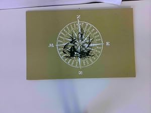
Montant total (1 article articles) :
Destination de la commande :

VISSCHER, NICOLAS (85 résultats)
Passer aux résultats principaux de la recherche
Type d'article
- Tous les types d'articles
- Livres (54)
- Magazines & Périodiques
- Bandes dessinées
- Partitions de musique
- Art, Affiches et Gravures (4)
- Photographies
- Cartes (27)
-
Manuscrits &
Papiers anciens
Etat
Reliure
Particularités
- Edition originale (1)
- Signé (1)
- Jaquette (2)
- Avec images (70)
- Sans impression ŕ la demande
Pays
Evaluation du vendeur
-
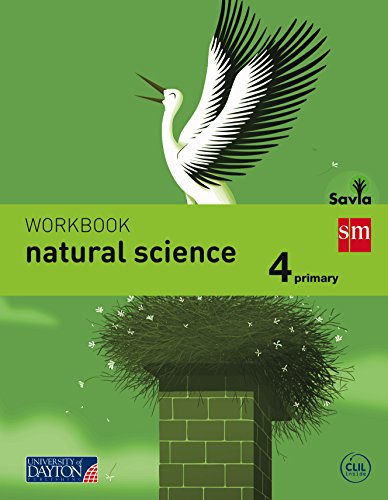
Savia, natural science, 4 Educación Primaria. Workbook
Edité par U.D. Publishing S.A. de C.V., 2015
ISBN 10 : 8415743742ISBN 13 : 9788415743743
Livre
Paperback. Etat : Brand New. Archivo De Ediciones SM; Fernández Prímola, Nicolás; Santolaya Ruiz Clavijo, Antonia; Asensio Moruno, Arturo; Alonso Rivero, Daniel; Moreno Arrastio, Félix; Santos González, José; Muńoz Tenllado, Antonio; Suri; Orbe Ferreiro, Alejandro De; Marquet, Myriam G.; Muńiz López, Jacobo; Montańá Ros, Marta; Navarro García, José Luis; Ovejero Sánchez, Ángel; León Celma, Pere Lluís; Shutterstock; Aznar Medina, María Ángeles; Nigot Giaux, Marie; García Ayerbe, Alberto; Aguado, Jesús; Artimagos, Estudio; Pérez De Muti, Marcelo; Berdugo Garvia, Guillermo; Solís Campos, Fermín; Cartanya, Mercé; Wimmer, Sonja; Tejerina Martínez, Germán; García Nieto, Pablo (illustrateur). Spanish language. 11.42x8.86x0.39 inches. In Stock.
Plus de choix d'achat de la part d'autres vendeurs sur AbeBooks
Offres neuf ŕ partir de EUR 20,02
Offres d'occasion ŕ partir de EUR 67,50
Trouvez également Couverture souple
-
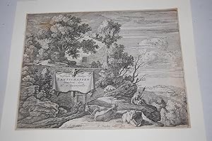
Versceyde Aerdige Lantschappen Geteckent door H. y. Swanevelt. ENGRAVING.
Edité par [17th-century]., [Holland?]
Vendeur : Dark Parks Books & Collectibles, Fallon, NV, Etats-Unis
Evaluation du vendeur :

Frontispiece? engraving for unidentified work. Mounted at corners on larger white hard stock paper. Suitable for framing.
-

Historische Karte: Britischen Inseln, nach 1717 (gerollt): Kartuscheninschrift: Magnae Britanniae Tabula; Comprehendens Angliae, Scotiae, ac Hiberniae . Provincias peraccurate et distincte divisa
Edité par Rockstuhl Verlag, 2011
ISBN 10 : 3867772940ISBN 13 : 9783867772945
Carte
Map. Etat : Brand New. German language. 24.72x2.20x2.20 inches. In Stock.
-
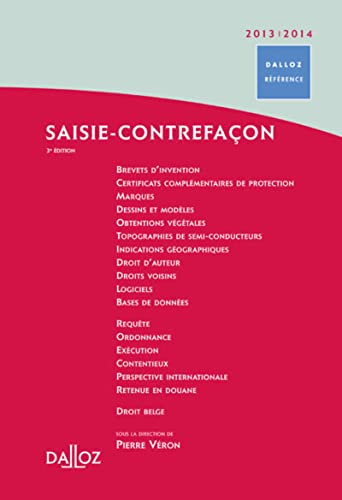
Saisie-contrefaçon 2013-2014
Edité par DALLOZ, 2012
ISBN 10 : 2247079253ISBN 13 : 9782247079254
Livre
Gut/Very good: Buch bzw. Schutzumschlag mit wenigen Gebrauchsspuren an Einband, Schutzumschlag oder Seiten. / Describes a book or dust jacket that does show some signs of wear on either the binding, dust jacket or pages.
-
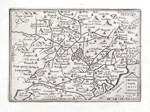
Romanum territorium
Edité par Visscher, Claes Jansz., Amsterdam, 1649
Vendeur : Antikvariat Krenek, Prag, Rébublique tchčque
Membre d'association : ILAB
Evaluation du vendeur :
"Romanum territorium". Orig. copperplate engraving from N. Visscher's "Tabulae Geographicae Contractae". Published in Amsterdam by C. J. Visscher, 1649. Engraved by P. Kaerius. With decorative title cartouche and the scale of map ("Milliaria Italica"). 8,5:12,5 cm. Koeman III, map 9500:341, ed. 341:54 (1649 Tabulae, Visscher). - A miniature map of Campagna di Roma.
-

Marcha Anconae olim Picenum. 1572
Edité par Visscher, Claes Jansz., Amsterdam, 1649
Vendeur : Antikvariat Krenek, Prag, Rébublique tchčque
Membre d'association : ILAB
Evaluation du vendeur :
"Marcha Anconae olim Picenum. 1572". Orig. copperplate engraving from N. Visscher's "Tabulae Geographicae Contractae". Published in Amsterdam by C. J. Visscher, 1649. Engraved by P. Kaerius. With decorative title cartouche and the scale of map ("Milliaria Italica"). 9:12,5 cm (3 1/2 x 5 inch.). Koeman III, map 7350:341, ed. 341:54 (1649 Tabulae, Visscher). - A miniature map of Marche. With the city of Ancona at the bottom. Oriented to the South.
-
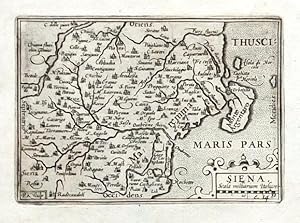
Siena
Edité par Visscher, Claes Jansz., Amsterdam, 1649
Vendeur : Antikvariat Krenek, Prag, Rébublique tchčque
Membre d'association : ILAB
Evaluation du vendeur :
"Siena". Orig. copperplate engraving from N. Visscher's "Tabulae Geographicae Contractae". Published in Amsterdam by C. J. Visscher, 1649. Engraved by P. Kaerius. With decorative title cartouche with the scale of map ("Scala milliarium Italicor"). 9:12,5 cm (3 1/2 x 5 inch.). Koeman III, map 7210:341, ed. 341:54 (1649 Tabulae, Visscher). - A miniature map of of the province of Siena in Tuscany. Oriented to the East.
-
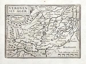
Veronensis Ager
Edité par Visscher, Claes Jansz., Amsterdam, 1649
Vendeur : Antikvariat Krenek, Prag, Rébublique tchčque
Membre d'association : ILAB
Evaluation du vendeur :
"Veronensis Ager". Orig. copperplate engraving from N. Visscher's "Tabulae Geographicae Contractae". Published in Amsterdam by C. J. Visscher, 1649. Engraved by P. Kaerius. With decorative title cartouche and the scale of map ("Scala Milliarium Italicorum"). 9:12,5 cm (3 1/2 x 5 inch.). Koeman III, map 7111:341, ed. 341:54 (1649 Tabulae, Visscher). - A miniature map of of the province of Verona. Oriented to the East. With the city of Verona in the centre and Lago di Garda at the bottom.
-
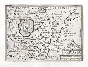
Perusia
Edité par Visscher, Claes Jansz., Amsterdam, 1649
Vendeur : Antikvariat Krenek, Prag, Rébublique tchčque
Membre d'association : ILAB
Evaluation du vendeur :
"Perusia". Orig. copperplate engraving from N. Visscher's "Tabulae Geographicae Contractae". Published in Amsterdam by C. J. Visscher, 1649. Engraved by P. Kaerius. With decorative title cartouche with the scale of map ("Scala milliarium Italicorum"). 9:12,5 cm (3 1/2 x 5 inch.). Koeman III, map 7340:341, ed. 341:54 (1649 Tabulae, Visscher). - A miniature map of of the province of Perugia. With the Lake Trasimeno ("Lago de Perugia") on the left.
-
Nova Totius Terrarum Orbis Geographica Ac Hydrographica Tabula. Farbiger Reprint einer Weltkarte, umgeben von zahlreichen Ansichten berühmter Eroberer und Feldherren sowie kleineren Stadt- und Landschaftsansichten
Edité par Selbstverlag
Carte
ausgefaltet ca. 39 x 32 cm. Etat : Sehr gut. Karte Farbiger Nachdruck einer Weltkarte, Unterkante sehr leicht bestoßen, Karte sonst sehr gut erhalten, ohne Jahresangabe, Sprache: Latein Ordner28 la Gewicht in Gramm: 201.
-
Totius Alsatiae Novissima Tabula, Qua Simul Sundgovia, Brisigavia, Ortenavia, Maxima Pars Marchionatus Badensis, Nec Non Aliae Insertae et Adjacentes Regiones .
Edité par Amsterdam, 1677
Vendeur : BALAGUÉ LLIBRERÍA ANTIQUŔRIA, Santa Coloma de Farners, GIRON, Espagne
Membre d'association : AILA ILAB
Evaluation du vendeur :
Carte
Sin Encuadernar. Etat : Papel Cansado. Con anotaciones manuscritas de época en los márgenes. Coloreado a mano de época. (Con un pequeńo roto en el centro) Size: 62 x 53,5 Cm.
-

Portrait of the painter Philip Wouwerman in an elaborate frame including elements recalling subjects usually represented by the painter: horses, hunting scenes a palette with brushes and birds. Lettered in the bottom center: 'PHILIPPUS / WOUWERMAN PICTOR / BATAVUS', signed on the bottom left:'C. de Visscher delineavit' and on the right:'N. Dupuis Sculp.' and in the center:'a Paris chez Huquier vis a vis le grand Chatelet.'l Engraving on paper, trimmed to platemark; total: 424 x 285 mm. Th.B 10, p. 184, Le Blanc 34, Nagler 3 PP01W (Wouwerman) / in black folders A-D [Dupuis].
-
Flandriae comitatus pars australis, in castellaniam Insulanam, balliviatum Duacensem, territorium Tornacensem .
Edité par Amsterdam, Schenk, (1730)., 1730
Carte 590 x 520 mm. Belle carte en couleurs des Flandres, de Arleux ŕ Menin, de La Bassée ŕ Condé. Couleurs époque.
-
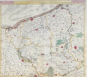
Carte : Flandriae comitatus pars occidentalis in terram Francam et ejusdem subjacentia officia accuratissima divisa.
Edité par Amsterdam, Schenk, (1730)., 1730
Carte 600 x 520 mm. Belle carte des Flandres, de Gravelines ŕ Ypres, de Aire ŕ Furnes. Nombreux de couleurs sur les limites administratives et politiques, les villes et forets. Couleurs époque.
-

Flandriae Comitatus in Ejusdem Subjacentes Ditiones Accuratissime Divisus Una Cum Adjancetibus.
Edité par Amsterdam, 1700
Vendeur : BALAGUÉ LLIBRERÍA ANTIQUŔRIA, Santa Coloma de Farners, GIRON, Espagne
Membre d'association : AILA ILAB
Evaluation du vendeur :
Carte
Sin Encuadernar. Etat : Papel Cansado. This map of the historical region of Flanders traces the coastline from Grevelingen to Zeeland at de Hont oste Westerschelde, south to below Douay, and east to Brussels. Western Belgium. Con anotaciones manuscritas de época en los márgenes. Coloreado a mano de época. Size: 63 x 53 Cm.
-
Herder in gesprek met een jonge herder op een ezel (Shepherd talking to a young shepherd on a donkey)
Date d'édition : 1670
Vendeur : Rob Zanger Rare Books LLC, Middletown, NY, Etats-Unis
Evaluation du vendeur :

Etching on handmade, cream laid paper. 5 13/16 x 7 5/8 inches (146 x 192 mm), thread margins. Scattered handling creases, light age tone, and minor paper inconsistoncies throughout. All consistent with age.
-
Moguntini Archiepiscopat et Electoratus nec non Comitatum utrisque Cattimeliboci Verthemensis & Erpachiensis.
Edité par Amsterdam, 1680
Vendeur : BALAGUÉ LLIBRERÍA ANTIQUŔRIA, Santa Coloma de Farners, GIRON, Espagne
Membre d'association : AILA ILAB
Evaluation du vendeur :
Carte
Sin Encuadernar. Etat : Bueno. Primera edición. Nicolas Visscher (*1618 - 1679). Iluminado a mano de época. Size: 62 x 54 Cm.
-
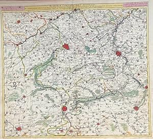
S. R. I. Sueviae Circulus Atq. Ducatus Una Cum Insertis et Adjacentibus Regionibus.
Edité par Amsterdam, 1705
Vendeur : BALAGUÉ LLIBRERÍA ANTIQUŔRIA, Santa Coloma de Farners, GIRON, Espagne
Membre d'association : AILA ILAB
Evaluation du vendeur :
Carte
Sin Encuadernar. Etat : Papel Algo Cansado. Map of the Baden-Württemberg region of Germany, and northern Switzerland. Relief shown pictorially. Illustrated title cartouche. Con anotaciones manuscritas de época en los márgenes. Coloreado a mano de época. Size: 62,5 x 53,5 Cm.
-

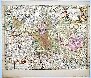
Bavariae Circulus Atq Electoratus Tam Cum Adjancentibus Quam Insertis Regionibus Accuratissime in Suasquasque Ditiones Divisus.
Edité par Amsterdam, 1704
Vendeur : BALAGUÉ LLIBRERÍA ANTIQUŔRIA, Santa Coloma de Farners, GIRON, Espagne
Membre d'association : AILA ILAB
Evaluation du vendeur :
Carte
Sin Encuadernar. Etat : Papel Algo Cansado. Con anotaciones manuscritas de época en los márgenes. Coloreado a mano de época. Size: 63 x 53,5 Cm.
-
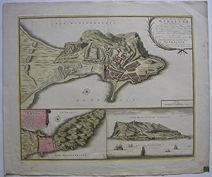
Plan de la Ville de Gibaltar, situé au Detroit de ce Nom. Cette Ville a pris son Nom d`une Montagne qui füt aisi Nom née de Tarik, fameux Capitaine des Maures, qui y posa son premier Camp, c`est pourquoy on l`appela Gibal-Tarik, en Langue Maure, comme qui diroit en Francois Montagne de Tarik en 1706.
Edité par Amsterdam, Visscher,, 1706
Vendeur : Antiquariat Werner Steinbeiß, München, Allemagne
Evaluation du vendeur :
Livre
dreiteilige altkolorierte Kupferstichkarte mit einem Plan von Gibraltar und Ceuta, rechts unten eine Ansicht der Stadt Gibraltar vom Meer aus, rechts oben Kartusche und Maßstab. - unten kleine Randeinrisse, rückseitig einige Bibliotheks-Stempel bzw. Aufkleber, farbfrisches Exemplar Sprache: Deutsch Gewicht in Gramm: 550 43 x 53 cm Blattgröße 53 x 62,5 cm.
-

Vechtae fundis, villis, praetoriis, atque priscis arcibus triumphantis, Tabula exqisitissima edita a Nic. Vischeri.
Edité par Artist: Visscher Nicolas ( - 1679 ) Amsterdam ; issued in: Amsterdam ; ca: 1610; - Nicolaes Visscher I (1618 -1679) Amsterdam was a Dutch engraver cartographer and publisher He belonged to the Dutch art dealer engraver and publisher dynasty founded by his father Claes Janszoon Visscher After his father's death in 1652 he took over his father's art publishing house and initially continued publishing the atlases and maps that his father had begun He then began publishing works under his own name Together with his son Nicolaes Visscher II (1649-1702) he engraved a large number of printing plates further replenishing the publisher's stock The atlases "Atlas Contractus" "Atlas Minor" and "Germania Inferior" contain about 170 plates After N Vissc, 1618
Vendeur : Antique Sommer& Sapunaru KG, München, Allemagne
Membre d'association : ILAB VDA
Evaluation du vendeur :

Art / Affiche / Gravure
Technic: Copper print; colorit: original colored; condition: Very good, size (in cm): 32 x 21; - Titlepage of N. Vischer,Vechtae fundis.
-
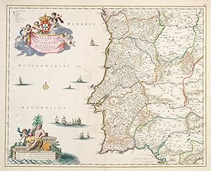
Portugalliae et Algarbiae Regna.
Date d'édition : 1680
Vendeur : Altea Antique Maps, London, Royaume-Uni
Membre d'association : ABA ILAB PBFA
Evaluation du vendeur :
Carte
Amsterdam, c.1680. Original colour. 505 x 530mm. Repairs to centre fold. A fine map of Portugal with decorative cartouches for the title and scale, both in full colour.
-
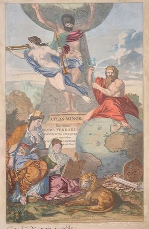
Atlas Minor Sive totius Orbis Terrarum Contracta delineat ex conatibus
Edité par Artist: Visscher Nicolas ( - 1679 ) Amsterdam ; issued in: Amsterdam ; ca: 1683; - Nicolaes Visscher I (1618 -1679) Amsterdam was a Dutch engraver cartographer and publisher He belonged to the Dutch art dealer engraver and publisher dynasty founded by his father Claes Janszoon Visscher After his father's death in 1652 he took over his father's art publishing house and initially continued publishing the atlases and maps that his father had begun He then began publishing works under his own name Together with his son Nicolaes Visscher II (1649-1702) he engraved a large number of printing plates further replenishing the publisher's stock The atlases "Atlas Contractus" "Atlas Minor" and "Germania Inferior" contain about 170 plates After N Vissc, 1618
Vendeur : Antique Sommer& Sapunaru KG, München, Allemagne
Membre d'association : ILAB VDA
Evaluation du vendeur :
Art / Affiche / Gravure
Technic: Copper print; colorit: original colored; condition: Margins lightly stained, size (in cm): 39 x 25 cm; - Title page of "Atlas Minor Sive totius Orbis Terrarum Contracta delineat ex conatibus Nicolas Visscher". It shows allegorical representations and the globe with Africa, partly Europe and South America.
-
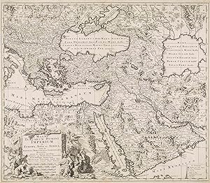
Magni Turcarum Domini Imperium in Europa, Asia et Africa; tam in Proprias, Tributarias, ac Clientelares Regiones, quam in omnes
Edité par Nicolas Visscher, Amsterdam, 1679
Carte
No Binding. Etat : Very Good. Engraving 50 x 57.5 cm. A very good copy of a map of the Turkish Empire by Nicolaes Visscher I, a renowned Dutch engraver, cartographer, and publisher.
-

Bavaria ducatus
Edité par Artist: Visscher Nicolas ( - 1679 ) Amsterdam ; issued in: Amsterdam ; ca: 1670; - Nicolaes Visscher I (1618 -1679) Amsterdam was a Dutch engraver cartographer and publisher He belonged to the Dutch art dealer engraver and publisher dynasty founded by his father Claes Janszoon Visscher After his father's death in 1652 he took over his father's art publishing house and initially continued publishing the atlases and maps that his father had begun He then began publishing works under his own name Together with his son Nicolaes Visscher II (1649-1702) he engraved a large number of printing plates further replenishing the publisher's stock The atlases "Atlas Contractus" "Atlas Minor" and "Germania Inferior" contain about 170 plates After N Vissc, 1618
Vendeur : Antique Sommer& Sapunaru KG, München, Allemagne
Membre d'association : ILAB VDA
Evaluation du vendeur :
Technic: Copper print; colorit: original colored; condition: Restoration at centerfold, lower missing part replaced, size (in cm): 38 x 49; - Map shows Upper Bavaria with Munich, Augsburg, Regensburg, Landshut, Passau, Tegernsee, Berchdesgaden, Kufstein, Salzburg etc. and a title cartouche.
-
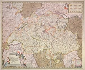
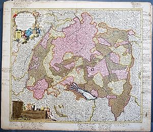
Exactißima Helvetiae Rhaetiae, Valesia Ceterorumque, Confoederatorum ut et finitimorum Populorum Regionum Tabula.
Edité par Artist: Visscher Nicolas ( - 1679 ) Amsterdam ; issued in: Amsterdam ; ca: 1680; - Nicolaes Visscher I (1618 -1679) Amsterdam was a Dutch engraver cartographer and publisher He belonged to the Dutch art dealer engraver and publisher dynasty founded by his father Claes Janszoon Visscher After his father's death in 1652 he took over his father's art publishing house and initially continued publishing the atlases and maps that his father had begun He then began publishing works under his own name Together with his son Nicolaes Visscher II (1649-1702) he engraved a large number of printing plates further replenishing the publisher's stock The atlases "Atlas Contractus" "Atlas Minor" and "Germania Inferior" contain about 170 plates After N Vissc, 1618
Vendeur : Antique Sommer& Sapunaru KG, München, Allemagne
Membre d'association : ILAB VDA
Evaluation du vendeur :
Technic: Copper print; colorit: original colored; condition: , size (in cm): 46,5 x 56,5 cm; - Princely map edition of Switzerland with three partially qouached cartouches.; - Special feature: Royal edition, heightened with gold.
-
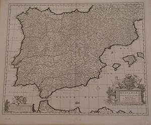
Hispaniae et Portugalliae regna. Per Nicolaum Visfcher. Cum privilegio ordinum Hollandia et Westfrisia.
Edité par Amsterdam, 1680., 1680
Vendeur : Librería Antonio Castro, SEVILLA, SE, Espagne
Membre d'association : AILA ILAB
Evaluation du vendeur :
Huella: 47x57. Papel: 53x63. Impresionante mapa de Espańa y Portugal, con parte de la costa africana. Grabado al cobre. Con cartela y escala muy decorativas. Muy buen ejemplar. Bella impresión.
-

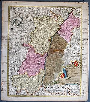
Landgraviatus Alsatiae Inferioris Novissima Tabula, in qua simul Marchionatus Badensis, Ortenavia Caeteraqtam Lotharingica quam alia Confinia,
Edité par Artist: Visscher Nicolas ( - 1679 ) Amsterdam ; issued in: Amsterdam ; ca: 1690; - Nicolaes Visscher I (1618 -1679) Amsterdam was a Dutch engraver cartographer and publisher He belonged to the Dutch art dealer engraver and publisher dynasty founded by his father Claes Janszoon Visscher After his father's death in 1652 he took over his father's art publishing house and initially continued publishing the atlases and maps that his father had begun He then began publishing works under his own name Together with his son Nicolaes Visscher II (1649-1702) he engraved a large number of printing plates further replenishing the publisher's stock The atlases "Atlas Contractus" "Atlas Minor" and "Germania Inferior" contain about 170 plates After N Vissc, 1618
Vendeur : Antique Sommer& Sapunaru KG, München, Allemagne
Membre d'association : ILAB VDA
Evaluation du vendeur :
Technic: Copper print; colorit: original colored; condition: Perfect condition, size (in cm): 46 x 56 cm; - Map shows the whole of Alsace in France with Strasbourg, Wissembourg, Sélestat (German: Schlettstadt), Saverne (German: Zabern), Hagenau and many more. Furthermore, a title cartouche with women, child and a cornucopia, the mythological symbol of happiness.
-
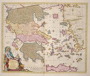
Exactissima totius Archipelagi nec non Graeciae Tabula
Edité par Artist: Visscher Nicolas ( - 1679 ) Amsterdam ; issued in: Amsterdam ; ca: 1680; - Nicolaes Visscher I (1618 -1679) Amsterdam was a Dutch engraver cartographer and publisher He belonged to the Dutch art dealer engraver and publisher dynasty founded by his father Claes Janszoon Visscher After his father's death in 1652 he took over his father's art publishing house and initially continued publishing the atlases and maps that his father had begun He then began publishing works under his own name Together with his son Nicolaes Visscher II (1649-1702) he engraved a large number of printing plates further replenishing the publisher's stock The atlases "Atlas Contractus" "Atlas Minor" and "Germania Inferior" contain about 170 plates After N Vissc, 1618
Vendeur : Antique Sommer& Sapunaru KG, München, Allemagne
Membre d'association : ILAB VDA
Evaluation du vendeur :
Technic: Copper print; colorit: original colored; condition: Very good, size (in cm): 46 x 56 cm; - Map shows the whole of Greece, the Aegean Sea and the island of Crete with two magnificent cartouches.
-

Luxemburgensis Ducatus, tam in ejusdem minores, quam principales Ditiones peraccurate Distinctus,.
Edité par Artist: Visscher Nicolas ( - 1679 ) Amsterdam ; issued in: Amsterdam ; ca: 1660; - Nicolaes Visscher I (1618 -1679) Amsterdam was a Dutch engraver cartographer and publisher He belonged to the Dutch art dealer engraver and publisher dynasty founded by his father Claes Janszoon Visscher After his father's death in 1652 he took over his father's art publishing house and initially continued publishing the atlases and maps that his father had begun He then began publishing works under his own name Together with his son Nicolaes Visscher II (1649-1702) he engraved a large number of printing plates further replenishing the publisher's stock The atlases "Atlas Contractus" "Atlas Minor" and "Germania Inferior" contain about 170 plates After N Vissc, 1618
Vendeur : Antique Sommer& Sapunaru KG, München, Allemagne
Membre d'association : ILAB VDA
Evaluation du vendeur :
Technic: Copper print; colorit: original colored; condition: Margin replaced with lower missing part, size (in cm): 49 x 58,5; - Decorative map of Luxembourg with its surrounding countries.