Montant total (1 article articles) :
Destination de la commande :

WILLEM BLEAU (10 résultats)
Passer aux résultats principaux de la recherche
Type d'article
- Tous les types d'articles
- Livres (6)
- Magazines & Périodiques
- Bandes dessinées
- Partitions de musique
- Art, Affiches et Gravures (2)
- Photographies
- Cartes (2)
-
Manuscrits &
Papiers anciens
Etat
- Tous
- Neuf
- Ancien ou d'occasion
Reliure
- Toutes
- Couverture rigide (1)
- Couverture souple
Particularités
- Edition originale (1)
- Signé (1)
- Jaquette
- Avec images (6)
- Sans impression ŕ la demande
Pays
Evaluation du vendeur
-
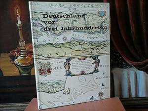
Deutschland vor drei Jahrhunderten. Seine Städte, Flüsse und Wälder.
Edité par Berlin, Bertelsmann, 1971
ISBN 10 : 357008888XISBN 13 : 9783570088883
Vendeur : Antiquariat im Schloss, Schwaigern, D, Allemagne
Evaluation du vendeur :

Livre Edition originale
Erste /1./ Ausgabe. 300 S., mit zahlreichen Abb. Gutes, wohl erhaltenes Exemplar. Sprache: Deutsch Gewicht in Gramm: 900 Farbillustr. Or.-Pappeinband. 4to (30x23 cm).
-

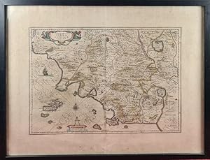
Etat : -. Gefaltete Kuperstich-Karte mit altem Grenzkolorit und altkolorierten Wappen und Kartusche. Blattmaß: 58 x 48 cm. Mit lateinischem Text recto. Gezeigt wird das Herzugtum Anjou und Umland. Leicht gebräunt. Breitrandiges, hübsches Exemplar!.
-
Saxonia Superior cum Lusatia et Misnia. (Amsterdam, ca. 1635). Kolorierte Kupferstichkarte 50,5 x 39 cm. Blattgröße 55,5 x 48 cm. Die Karte zeigt Sachsen mit Ober- und Unterlausitz, Teile des Vogtlandes, Schlesien und Böhmen. Der Kartentitel erscheint am oberen Rand in Form einer Draperie. Oben rechts ein graphischer Maßstab (Milliaria Germanica Communia). Auf der Rückseite die Seiten 13 und 16 der lateinischen Ausgabe des Atlanten von Bleau mit der Überschrift "Saxonia Superior, cum Lusatia et Misnia".- Die Karte ist leicht gebräunt, und hat 2 leichte Knickfalten, die Mittelfalz ist unterlegt. Insgesamt von guter Erhaltung.
Vendeur : Antiquariat Renner OHG, Albstadt, Allemagne
Membre d'association : BOEV
Evaluation du vendeur :
-
Saxonia Superioris, Lusatiae Misniae Que descripto. (Amsterdam, ca. 1644). Kolorierte Kupferstichkarte 50,5 x 39 cm. Blattgröße 55,5 x 48 cm. Die Karte zeigt Sachsen mit Ober- und Unterlausitz, Teile des Vogtlandes, Schlesien und Böhmen. Oben links Titelkartusche, oben rechts graphischer Maßstab (Miliaria Germanica Communia). Auf der Rückseite die Seiten 493 und 496 der französischen Ausgabe des Atlanten von Bleau mit der Überschrift "Duche de la Haute Saxe, avec la Misne et Lusace. Le VIII Cicle de l'Empire, Ober Saxen".- Die Karte ist leicht gebräunt, die Ränder etwas stärker. Die Mittelfalz ist hinterlegt. Insgesamt von guter Erhaltung.
Vendeur : Antiquariat Renner OHG, Albstadt, Allemagne
Membre d'association : BOEV
Evaluation du vendeur :
-

Legionis Regnum et Asturiarum Principatus".
Vendeur : Antiquariat Werner Steinbeiß, München, Allemagne
Evaluation du vendeur :
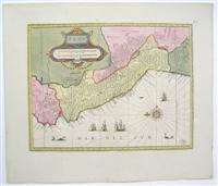
Carte
Altkolorierte Kupferstichkarte von Wilem J. Bleau, Amsterdam, ca. 1610. Königreich Leon und Fürstentum Asturias, links Teile von Galicien, oben Kantabrisches Meer, links unten Kartusche, flankiert von zwei Löwen, darüber Wappen von Leon, rechts unten Meilenanzeiger in Rocaille-Kartusche. - senkrechte Quetschfalte rechts neben dem Falz, sonst gut erhaltenes, breitrandiges Exemplar Sprache: Deutsch Gewicht in Gramm: 550 38 x 49 cm Blattgröße 53,5 x 62,5 cm.
-
Archevesché de Cambray. A Hand-Colored map showing Flanders and Belgium, with Cartouche in lower left corner showing both the Gallic and Germanic Scales. Latin Text on verso
Edité par Amsterdam, 1670
Vendeur : James Cummins Bookseller, ABAA, New York, NY, Etats-Unis
Membre d'association : ABAA ILAB
Evaluation du vendeur :
1 vols. 60.4 x 50.8 cm. 1 vols. 60.4 x 50.8 cm. One small brown spot near center, else very attractive map. Matted and wrapped.
-
WILLEM JANSZOON AND JOAN BLEAU. MAPA DE SIENA Y DUCADO DE CASTRO. CIRCA 1640.
Vendeur : Arte & Antigüedades Riera, Barcelona, BCN, Espagne
Evaluation du vendeur :
Selecciona. Etat : Selecciona. WILLEM JANSZOON AND JOAN BLEAU. MAP OF SIENA AND DUCHY OF CASTRO. CIRCA 1640 WORK BY ENGRAVER WILLEMM JANSZOON AND JOAN BLEAU. AMSTERDAM. MAP OF THE SIENA REGION AND THE DUCHY OF CADTRO IN ITALY. SCALE DI MIGLIA NOVE D"ITALIA. HERITAGE OF S. PIETRO. COPPER ENGRAVING ON COLOR PAPER. CIRCA 1640 MEASURES OF THE WORK: 65 X 53.5 CM YOU CAN SEE THE DETAILS IN THE PICTURES.
-
Perv
Edité par Amsterdam, 1653
Vendeur : Alexandre Antique Prints, Maps & Books, Toronto, ON, Canada
Membre d'association : ABAC ILAB
Evaluation du vendeur :

Carte
Etat : Excellent. Size : 379x488 (mm), 14.875x19.25 (Inches), Original Hand Coloring.
-
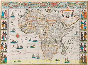
Africae nova descriptio Copper engraving with outline colour to cartographical image and full colour to pictorial borders
Vendeur : Inter-Antiquariaat Mefferdt & De Jonge, Amsterdam, Pays-Bas
Membre d'association : ILAB NVVA
Evaluation du vendeur :
Art / Affiche / Gravure
Africae nova descriptio Copper engraving with outline colour to cartographical image and full colour to pictorial borders. Published in Amsterdam by Willem Jansz. and Joan Blaeu c. 1640. Size: 41 x 55,5 cm. In handsome walnut frame. This is a cornerstone map of Africa and is one of the better known, more decorative maps of Africa of the seventeenth century. The map shows major African towns across the top: Tangiers, Ceuta, Algiers, Tunis, Alexandria, Cairo, the island of Mozambique, The Mine at St. George in Guinea and Canaria in the Canary Islands. The left and right borders show various indigenous costumes: Moroccans, Senegalese, traders in Guinea, Congolese, Egyptians, Abyssinians, Mozambicans, the king of Madagascar and inhabitants of Cape of Good Hope. The body of the map is richly embellished with animals, including elephants, monkeys, ostriches, gazelles, lions, cheetahs and camels. In the oceans are numerous sailing ships, sea monsters, flying fish, and a gorgeous compass rose. Much of the geographical information is still based on the Ptolemaic maps, with the Nile shown with its source in the Lakes Zaire and Zaflan. Also included are various other mythical lakes and rivers including the famous Lake Sachaf. Only coastal towns are named on the Cape, with the printing covering much of the unknown territory. Willem Janszoon, or Willem Jansz. Bleau (1571-1638) as he was to be later more commonly known, was one of the noted Dutch cartographers and map publishers of the seventeenth century. After preparation as a pupil of the great Danish astronomer Tycho Brahe, Bleau initially concentrated on globemaking and separately published maps, including wall maps of the continents. From 1608, he dominated the market for wall maps and sea atlases, and in 1630 produced his terrestrial atlas. These atlases were continued by his sons Joan (c. 1599-1673) and Cornelis (1610-1644), culminating in the great Atlas Maior of 1662 in 11 volumes by Joan Bleau with subsequent editions. On February 23, 1672 a fire at the offices of the Bleau publishing effectively ended the successful Bleau business. Joan died after the fire in 1673, and, though Joan II continued the business for some time, many of the plates were auctioned shortly thereafter. This map was not reprinted after 1672 as the Africa copperplate is not known to have survived the fire. The Spanish edition of the Atlas Maior was in the process of being printed, including the section on Africa with this map of Africa, when the fire occurred. Blaeu's maps set the standard for the quality of the engraving, paper and colour, as well as a fine depiction of contemporary geographical knowledge. Price: Euro 2.850,- (incl. frame).
-
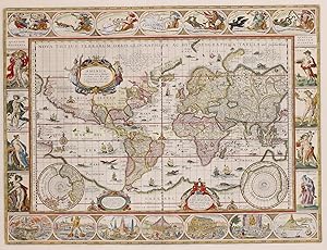
ICONIC WORLD MAP BY WILLEM BLAEU "Nova Totius Terrarum Orbis Geographica Ac Hydrographica Tabula" copper engraving first published in 1606 by Willem Blaeu in Amsterdam
Vendeur : Inter-Antiquariaat Mefferdt & De Jonge, Amsterdam, Pays-Bas
Membre d'association : ILAB NVVA
Evaluation du vendeur :
Art / Affiche / Gravure Signé
ICONIC WORLD MAP BY WILLEM BLAEU "Nova Totius Terrarum Orbis Geographica Ac Hydrographica Tabula" copper engraving first published in 1606 by Willem Blaeu in Amsterdam. Coloured by a later hand. Size: 55 x 41 cm. Nice example of Blaeu's classic world map in the so-called Mercator projection. This is one of the most famous landmarks of 17th-century cartography. Engraved and signed by Joshua van den Ende, reduced from Blaeu's wall map of 1605, it first appeared as a separate publication in 1606. In 1630 it was incorporated into Willem Blaeu's "Atlantis Appendix" and then into the "Atlas Novus" in all subsequent editions until 1658. Its influence was enormous, and it was closely copied by some of the greatest Dutch cartographers, such as Pieter van der Keere and Johannes Janssonius. Others, such as the house of Hondius, were forced to produce their own highly decorative maps to compete. Geographically, the map was a reduction of Blaeu's large map of the world published in 1605. The charming cartouche in the interior of North America mentions its discovery by Columbus in 1492 and being named after Amerigo Vespucci in 1499. There is some confusion in the depiction of the landmass of the East coast of the United States, probably as a result of Indian reports of large bodies of water inland, almost certainly the Great Lakes. California is correctly shown as a peninsula. The Le Maire straits, separating Tierra del Fuego from South America, copied from an earlier map by Hondius, are clearly shown. In the north, a note beside "Nova Zembla" in the Arctic declares that it was reached by Willem Barentsz in 1596. In the Far East Korea is shown as an island and northern Australia is shown without any place names. Decoratively the most striking features of this map are the magnificent and innovative panelled borders. The upper border shows allegorical figures of the sun and moon and the five known planets; Mercury, Venus, Mars, Jupiter and Saturn. Along the bottom border are depictions of the seven wonders of the ancient world; the Hanging Gardens of Babylon, the Colossus of Rhodes, the Great Pyramid at Giza, the Mausoleum at Hallicarnassus, the Temple of Artemis at Ephesus, the Statue of Zeus at Olympia and the Lighthouse of Alexandria. Running down the left hand side of the map are representations of the four elements (Fire, Air, Water and Earth) and on the right, the Four Seasons. In the cartouche in the lower right Blaeu dedicated the map to Cornelis Hooft, the Dutch merchant and Amsterdam regent during the Golden Age. . Reference : Rodney Shirley "The Mapping of the World', no. 255 Price: Euro 11.500,-.