Montant total (1 article articles) :
Destination de la commande :

anville jean baptiste bourgignon (23 résultats)
Passer aux résultats principaux de la recherche
Type d'article
- Tous les types d'articles
- Livres (19)
- Magazines & Périodiques
- Bandes dessinées
- Partitions de musique
- Art, Affiches et Gravures
- Photographies
- Cartes (4)
-
Manuscrits &
Papiers anciens
Etat
Reliure
Particularités
Pays
Evaluation du vendeur
-
A Complete Body of Ancient Geography. by Mons. D'Anville, .
Edité par Gale Ecco, Print Editions, 2010
ISBN 10 : 1170767168ISBN 13 : 9781170767160
Livre
Etat : New.
Plus de choix d'achat de la part d'autres vendeurs sur AbeBooks
Offres neuf ŕ partir de EUR 18,24
-
A Complete Body of Ancient Geography. By Mons. D'Anville,
Edité par Gale Ecco, Print Editions, 2018
ISBN 10 : 1385327804ISBN 13 : 9781385327807
Livre
Etat : New.
Plus de choix d'achat de la part d'autres vendeurs sur AbeBooks
Offres neuf ŕ partir de EUR 28,45
-
Compendium of Ancient Geography, by Monsieur D'Anville, . Translated From the French. (Hardback or Cased Book)
Edité par Gale Ecco, Print Editions 4/19/2018, 2018
ISBN 10 : 1379675642ISBN 13 : 9781379675648
Vendeur : BargainBookStores, Grand Rapids, MI, Etats-Unis
Evaluation du vendeur :

Livre
Hardback or Cased Book. Etat : New. Compendium of Ancient Geography, by Monsieur D'Anville, . Translated From the French. 3.1. Book.
Plus de choix d'achat de la part d'autres vendeurs sur AbeBooks
Offres neuf ŕ partir de EUR 48,52
-
Compendium of ancient geography, by Monsieur d'Anville, . Translated from the French. .
Edité par Gale Ecco, Print Editions, 2010
ISBN 10 : 1170608698ISBN 13 : 9781170608692
Livre
Etat : New.
Plus de choix d'achat de la part d'autres vendeurs sur AbeBooks
Offres neuf ŕ partir de EUR 46,26
Offres d'occasion ŕ partir de EUR 76,92
Trouvez également Couverture souple
-
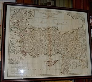
Asia quae Vulgo, Minor Dicatur,et Syria, Tabula Geographic.
Edité par Laurie & Whittle (Kitchen's General Atlas), London, 1794
Vendeur : James Howell Rare Books, Dublin, IRELA, Irlande
Evaluation du vendeur :
Carte Edition originale
No Binding. Etat : Very Good. No Jacket. 1st Edition. Striking map of Asia Minor depicting a large area of Turkey down to Syria and Mesopotamia (Iraq) Includes the Islands of Crete and Cyprus in the Mediterranean.Locates many states in Turkey and Kingdoms in Syria and Iraq. Includes a fine depiction of the Black Sea with it's extensive shoreline. A very handsome map. d'Anville was Cartographer to the King of France. Original Hand coloring in outline. 24x20 inches (48x40 cm) Contact the seller regarding shipping.
-
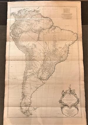
Amerique Meridionale publie sous les auspices de Monseigneur le Duc D´Orleans
Edité par Paris, 1748
Vendeur : Libreria Pontes, Madrid, MADRI, Espagne
Membre d'association : AILA ILAB
Evaluation du vendeur :
Carte
Sin Encuadernar. Etat : Muy bien. Original engraved map in three sheets joined together.Outline original colour.138 x 85 cms.A fine engraved map by De la Haye. This map was considered very detailed for the Perou, Colombia and Parana areas. The geographical sources were la Condamine,Bouguer and Maldonado for the territories of the Viceroyalty of Peru. This map remained as an influential geographical source until the publication of the accurate map by Cano y Olmedilla in 1775.
-
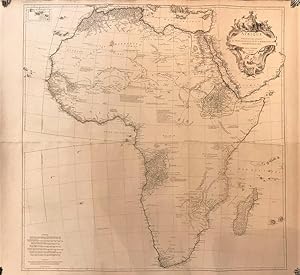
Afrique, publié sous les auspices de Monseigneur le Duc d´Orleans
Edité par Paris, 1749
Vendeur : Libreria Pontes, Madrid, MADRI, Espagne
Membre d'association : AILA ILAB
Evaluation du vendeur :
Carte
Sin Encuadernar. Etat : Muy bien. Engraved map in two sheets and joined with outline original handcolour.114 x 104 cms.Slightly cracked and rubbed on margins.This is one of the larger and most important and influential maps of the XVIII century. He had already published a map in 1727 but was updated by this map published in 1749.This map is considered nowadays rare as it appears in some composite french atlases either published by Anville or other cartographers. Anville was a prolific publisher and cartographer active in the first half of the XVIII century in France. Ref: Tooley Maps of Africa p 3-4.
-
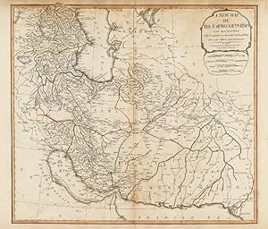
A New Map of The Empire of Persia from Mon. D. Anville, Geographer to the most Christian King, with Additions and Emendations.
Edité par London, Laurie & Whittle, 1794., 1794
Vendeur : Antiquariat INLIBRIS Gilhofer Nfg. GmbH, Vienna, A, Autriche
Membre d'association : ILAB VDA VDAO
Evaluation du vendeur :
Engraved map, outline colour (725 x 542 mm). Decorative large format 18th Century map of the Persian Empire, by one of England's leading map publishing firms of the late 18th Century. - Minor soiling and offsetting. - Al-Qasimi 212. Not in Tibbetts, Al Ankary.
-
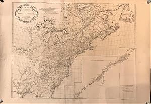
Canada, Lousiane et Terres Angloises
Edité par Paris, 1745
Vendeur : Libreria Pontes, Madrid, MADRI, Espagne
Membre d'association : AILA ILAB
Evaluation du vendeur :
Carte
Sin Encuadernar. Etat : Muy bien. Engraved map of Canada and Louisiana,137 x 98 cms. With a large inset map of the St. Lawrence River.Some very light browning. Wide margins An important French and Indian War map. "This map is based on that of Mitchell, which appeared earlier in the same year [the] inclusion of the St. Lawrence River inset (Le Fleuve Saint-Laurent represente plus en detail.) and some increased detail from French sources of information, show diffrences from the Mitchell 1755" (Cumming 296); Kershaw, 353. A very good copy of this scarce map.
-
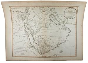
A New Map of Arabia, Divided Into Its Several Regions and Districts.
Edité par London, Laurie & Whittle, 1794., 1794
Vendeur : Antiquariat INLIBRIS Gilhofer Nfg. GmbH, Vienna, A, Autriche
Membre d'association : ILAB VDA VDAO
Evaluation du vendeur :
Hand-coloured engraved map (61 x 46 cm). Detailed map of the Middle East, published by Laurie & Whittle in London. Includes interesting annotations, including a note about the Barren Desert in the interior of the peninsula. - Al-Qasimi 211. Not in Tibbetts. Cf. Al Ankary 382.
-
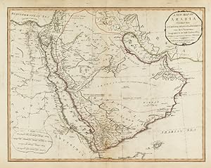
A New Map of Arabia, Divided Into Its Several Regions and Districts from Mon. D. Anville Geographer to the most Christian King with Additions and Improvements of M. Niebuhr.
Edité par London, Laurie & Whittle, 1794., 1794
Vendeur : Antiquariat INLIBRIS Gilhofer Nfg. GmbH, Vienna, A, Autriche
Membre d'association : ILAB VDA VDAO
Evaluation du vendeur :
Engraved map, outline colour (725 x 542 mm). Detailed map of the Middle East, published by Laurie & Whittle in London. Includes interesting annotations, including a note about the Barren Desert in the interior of the peninsula. - Minor soling and spotting near centerfold. - Al-Qasimi 211. Not in Tibbetts. Cf. Al Ankary 382.