
Montant total (1 article articles) :
Destination de la commande :

blaeu guillaume (9 rťsultats)
Passer aux rťsultats principaux de la recherche
Type d'article
- Tous les types d'articles
- Livres (7)
- Magazines & Pťriodiques
- Bandes dessinťes
- Partitions de musique
- Art, Affiches et Gravures
- Photographies
- Cartes (2)
-
Manuscrits &
Papiers anciens
Etat
- Tous
- Neuf
- Ancien ou d'occasion
Reliure
Particularitťs
- Edition originale (2)
- Signť
- Jaquette (1)
- Avec images (7)
- Sans impression ŗ la demande
Pays
Evaluation du vendeur
-
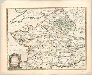
Impression de l'imprimerie Blaue, sans date (vers 1638). Carte de la souverainetť de Dombes limitťe par le RhŰne et la SaŰne jusqu'ŗ Lyon ; reprťsentation symbolique des montagnes, forÍts, villes, villages et places fortes ; mise en place du rťseau hydrographique et des limites territoriales ; titre et ťchelle prťsentťs dans des cartouches de cuir dťcoupť, portťs par des angelots et leurs attributs : sphŤre cťleste, globe terrestre, glaive et balance, serpent et miroir ; dans l'angle supťrieur gauche : armoiries de la souverainetť de Dombes. A noter que la reprťsentation plutŰt rare d'est en ouest. …chelle entre deux angelots en ę Militaria gallica communia Ľ. Carte de la souverainetť de Dombes rťalisťe dans le 2e quart du 17e siŤcle par Guillaume Blaeý, graveur et gťographe Hollandais et Jean, son fils ; cette estampe semble avoir ťtť exťcutťe avant 1638 date du dťcŤs de Guillaume Blaeý (1571-1638) ; les armoiries de la principautť de Dombes sont inscrites, ici, dans un ťcu losangť attribuť aux jeunes filles nobles. Petite dťchirure ŗ la pliure. Texte au dos en latin.
-
Typus Galliae Veteris - An attractive map of ancient France.
Editť par c. 1630, 1630
Vendeur : Curtis Wright Maps, Berwyn, IL, Etats-Unis
Membre d'association : ESA MWABA
Evaluation du vendeur :

Etat : Fine. This fascinating map of Roman Gaul was originally created by the famed cartographer Abraham Ortelius and included in the Paregon, an atlas of classical geography that typifies the contemporary interest in ancient Greek and Roman history during the 16th century. This particular example was issued in Amsterdam several decades later, around 1630 by the talented Blaeu publishing firm. The image reflects Ortelius' tremendous scholarship on the period. Various Roman polities - cities, regions, etc. - are labeled throughout the image in addition to approximate areas inhabited by various barbarian tribes. Geographic features are depicted pictorially, with the Ardennes Forest and Pyrenees Mountains identified (among others). In addition to heavily leveraging Caesar's Commentaries for the map's content, various annotations also reflect input from Strabo, Pliny, and Tacitus. A decorative strapwork title cartouche, lower left, credits both the original author and updated publisher. Sheet Width (in) 22.4 Sheet Height (in) 18.2 Condition Description Moderate wear visible around the outer edges of the sheet, including light discoloration and numerous small tears confined to the margins. Very good condition with attractive modern hand color. German text on verso.
-
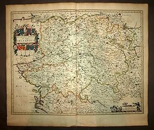
Carte gťographique ancienne de Guillaume BLAEU, GOUVERNEMENT DU PAYS D'ORL…ANS
Editť par Guillaume BLAEU, 1680
Vendeur : Librairie Maxime Katz, Villeurbanne, FR, France
Evaluation du vendeur :

Carte Edition originale
Pas de couverture. Etat : Bon. Edition originale. GOUVERNEMENT GENERAL DU PAYS ORLEANOIS Par BLAEU Guillaume A Amsterdam Circa 1680 Gravure sur cuivre Papier pur chiffon Coloris d ťpoque 65 x 55 centimŤtres (format hors tout) 60 x 47 centimŤtres (format de l illustration) TrŤs belle ťtat (voir les photos) GRAVURE CARTE ORIGINALE DE 1680.
-
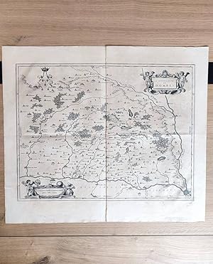
Carta raffigurante il territorio di Trento, basata sul modello maginiano. Si trova in: "Le Theatre du Monde, ou Novel Atlas, mis en lumiŤre par Guillaume & Jean Blaeu". Le tre figure maschili in costume d'epoca poste a decorazione del cartiglio in basso a destra sono forse identificabili in quei viaggiatori e mercanti che all'epoca stavano facendo la fortuna dell'Olanda. Scheda bibliografica tratta da "Il territorio trentino-tirolese nell'antica cartografia" di Gino Tomasi, scheda n. 26. Una copia Ť disponibile acquerellata. Formato: Incisione su rame di dimensioni 36x48 cm. Buono, ordinari segni d'uso e del tempo. Buono, ordinari segni d'uso e del tempo.
-

Rhenolandiae et Amstellandiae exactissima Tabula.
Editť par c.1640, Amsterdam, 1640
Vendeur : Alexandre Antique Prints, Maps & Books, Toronto, ON, Canada
Membre d'association : ABAC ILAB
Evaluation du vendeur :

Carte
Etat : Excellent. Decorative map of Holland regions of Rhineland and Amstelland., Size : 406x496 (mm), 15.98x19.53 (Inches), Hand Colored.
-
Lugduni Batavorum Apud Johannem Elzevirium, Academ. Typograph. 1655/ A Amsterdam, chez Jean & Corneille Blaeu, 1642, 2 parties reliťes en 1 volume in-8 de 202x150x45 mm environ, en tÍte : Historiae Philosophicae, Georges HORNIUS, 1f.blanc, 8-387 pages, 10ff. (index), (texte en latin) - suivi de : L'Usage des Globes et Spheres, de Willem BLAEU : 18 ff. (titre, prťface, argument)-277 pages, 1f.blanc, reliure de l'ťpoque, pleine basane brune, dos ŗ nerfs ornť de caissons ŗ motifs dorťs, tranches mouchetťes de brun et rouge. Quelques rousseurs, une coiffe ťbrťchťe, galeries de ver sur un mors et le dernier plat, cuir frottť et ťpidermť, sinon bon ťtat pour cet important traitť illustrť de figures sur bois dans le texte,notre exemplaire est la traduction originale de ce texte paru pour la premiŤre fois en hollandais en 1620. Willem Jansz Blaeu (1571-1638). Janssonius Blaeuw. Imprimeur-libraire et ťditeur de cartes et d'atlas. Originaire d'Alkmaar ou des environs. Passe 2 ans auprŤs de Tycho Brahť au Danemark. ņ son retour ŗ Amsterdam en 1596, s'ťtablit cartographe et fabricant de globes terrestres et cťlestes. IL monte ensuite une imprimerie et une fonderie. …galement auteur d'ouvrages cartographiques et astronomiques.
-
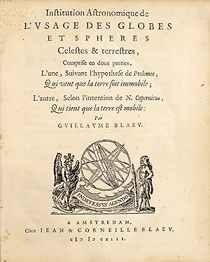
Institution Astronomique de l'usage des globes et sphŤres Celestes & terrestres, Comprise en deux parties, L'une, Suivant l'hypothese de Ptolemee, Qui veut que la terre soit immobile ; L'autre, Selon l'intention de N. Copernicus, Qui tient que la terre est mobile.
Date d'ťdition : 1642
Vendeur : Librairie Camille Sourget, Paris, France
Membre d'association : ILAB
Evaluation du vendeur :

Couverture rigide. Etat : TrŤs bon. Amsterdam, chez Jean & Corneille Blaeu, 1642.In-4 de (9) ff., 277 pp., nombreux bois gravťs dans le texte. Vťlin ŗ recouvrement, dos lisse avec le titre manuscrit, restes de laniŤres. Reliure de l'ťpoque.192 x 154 mm. --- Rare ťdition originale franÁaise de ce traitť sur l'utilisation des diffťrents instruments d'astronomie.Graesse, Trťsor de livres rares, 435 ; Stevenson, Terrestrial and Celestial globes, p. 223.L'ťdition originale fut publiťe en hollandais en 1620 au format in-8.L'ouvrage, publiť par Jean et Corneille Blaeu, les fils de Guillaume Blaeu, est divisť en deux parties, la premiŤre se basant sur la thťorie de Ptolťmťe, la seconde sur l'ťtude de Copernic, suivant en cela l'arrangement du Dialogo de Galilťe.On y trouve la maniŤre de tracer les cadrans.ę The master globe-maker authored the ?Institution Astronomique' so that his customers might get the most out of his celestial and terrestrial globes. Blaeu gives a detailed explanation of the various parts of a globe, followed by a series of nearly 150 exercises. By positioning the terrestrial globe as Blaeu directs, it is a simple matter to determine the time in different parts of the world. There are exercises for both the celestial globe and the terrestrial globe."Willem Jansoon Blaeu (1571-1638), astronome et mathťmaticien hollandais, est cťlŤbre pour avoir perfectionnť la cartographie. Il fonda sa propre imprimerie ŗ Amsterdam et put y publier ses travaux. Ses fils, Johan et Cornelis, poursuivirent son oeuvre.ę This work gave accounts of the opposing Ptolemaic and Copernican systems of the planets, as Blaeu thought the Ptolemaic system was still a useful introduction to the topic. Blaeu had worked on the island of Hven with Tycho Brahe and was a firm adherent to the Copernican system. It should be remembered that Galileo was condemned for his Copernican stance just the previous year, but Blaeu, publishing his works in the Protestant Netherlands, was not subject to t /// Amsterdam, chez Jean & Corneille Blaeu, 1642.4to [192 x 154 mm] of (9) ll., 277 pp., many woodcuts in the text. Overlapping vellum, flat spine with handwritten title, remains of ties. Contemporary binding. --- Rare first French edition of this treatise dealing with the use of astronomical instruments. Graesse, Trťsor de livres rares, 435 ; Stevenson, Terrestrial and Celestial globes, p. 223.The first edition was published in Dutch in 1620 in 8vo format. The work, published by Jean and Corneille Bleau, the sons of Guillaume Blaeu, is divided into two parts, the first one based on Ptolemy's theory, the second one on Copernicus's study, following the arrangement of Galileo's Dialogo.We find here the way to draw dials."The master globe-maker authored the ?Institution Astronomique' so that his customers might get the most out of his celestial and terrestrial globes. Blaeu gives a detailed explanation of the various parts of a globe, followed by a series of nearly 150 exercises. By positioning the terrestrial globe as Blaeu directs, it is a simple matter to determine the time in different parts of the world. There are exercises for both the celestial globe and the terrestrial globe."Willem Jansoon Blaeu (1571-1638), a Dutch astronomer and mathematician, is famous for having perfected cartography. He founded his own printing house in Amsterdam and was able to publish his own works. His sons, Johan and Cornelis, pursued his work.ę This work gave accounts of the opposing Ptolemaic and Copernican systems of the planets, as Blaeu thought the Ptolemaic system was still a useful introduction to the topic. Blaeu had worked on the island of Hven with Tycho Brahe and was a firm adherent to the Copernican system. It should be remembered that Galileo was condemned for his Copernican stance just the previous year, but Blaeu, publishing his works in the Protestant Netherlands, was not subject to the prohibitions of the Roman Catholic authorities".The present edition is illu.
-
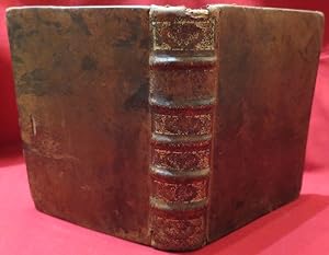
Theatrum Orbis Terrarum. sive Atlas Novus. Pars Quarta [England & Wales]
Editť par Johannem Blaeu, Amsterdami, 1646
Vendeur : Madoc Books (ABA-ILAB), Llandudno, CONWY, Royaume-Uni
Membre d'association : ABA ILAB IOBA PBFA
Evaluation du vendeur :
Livre
Hardcover. Etat : Very Good. BLAEU Johannes & Guillaume (illustrateur). 2nd Edition. In contemporary Dutch full boxed vellum, retaining evidence of green linen ties, yapp edges, a few minor scuffs & marks, near contemporary faint manuscript title to spine. Internally, title leaf, [8], 460, [1], ie: engraved allegorical title & fifty eight engraved maps (counted in paginations & register, all folding except for the Isle of Man; Bedfordshire & Buckinghamshire both on the one sheet), all with contemporary hand colouring, 4 engraved vignettes in the text (half page, also hand-coloured & depicting henges, burial chambers & mausolea), mounted on guards throughout (evidence of skillful removal & replacement), heavily water stained throughout causing some 'bleeding' of old watercolour, some maps heavily toned, (497*311 mm). (Koeman Bl 44 (volume 1 pp. 178-80). Skelton 42; cf. Chubb LIX-LX.) Second edition in Latin of this 'very fine atlas of the English counties compiled, mainly from the maps of John Speed' (Chubb). A total of six volumes were published. The present volume, depicting England and Wales, first appeared in 1645 and was reissued in 1646.
-
Le theatre du Monde ou Nouvel Atlas,mise en lumiŤre par Guillaume et Iean Blaeu Quatriesme partie
Editť par Ioannem Blaeu, Amsterdam, 1645
Livre Edition originale
Couverture souple. Etat : Bon. Etat de la jaquette : Bon. Edition originale. Le Thť‚tre du monde, ou nouvel atlas.quatrieme partie [Theatrum, volume IV: England and Wales] BLAEU, Willem (1571-1638) & Jan BLAEU (1596-1673) Britannia Description # 380 pagess + Scotia & Ireland avec 60 Carte doubles -( 500 + 7 ) Tome Weight Kg.8,400 Editore: Amsterdam (1645) Usato Rilegato Language : French text Size: 360 x540 mm.


![Image du vendeur pour Theatrum Orbis Terrarum. sive Atlas Novus. Pars Quarta [England & Wales] mis en vente par Madoc Books (ABA-ILAB)](https://pictures.abebooks.com/inventory/md/md31459419176.jpg)