Montant total (1 article articles) :
Destination de la commande :

blaeu joan krogt der taschen (5 résultats)
Passer aux résultats principaux de la recherche
Type d'article
- Tous les types d'articles
- Livres (5)
- Magazines & Périodiques
- Bandes dessinées
- Partitions de musique
- Art, Affiches et Gravures
- Photographies
- Cartes
-
Manuscrits &
Papiers anciens
Etat
- Tous
- Neuf
- Ancien ou d'occasion
Reliure
- Toutes
- Couverture rigide
- Couverture souple
Particularités
- Edition originale (3)
- Signé
- Jaquette (2)
- Avec images (3)
- Sans impression ŕ la demande
Livraison gratuite
Pays
Evaluation du vendeur
-

Atlas Maior of 1665 - Italia / Italy / Italien
Edité par TASCHEN, 2006
ISBN 10 : 3822851078ISBN 13 : 9783822851074
Vendeur : Michener & Rutledge Booksellers, Inc., Baldwin City, KS, Etats-Unis
Evaluation du vendeur :

Livre
Hardcover. Etat : Very Good. Etat de la jaquette : Very Good. Text clean and solid; light wear to dust jacket; NOTE: additional postage may be necessary for international shipping; 8vo 8" - 9" tall; 208 pages.
-
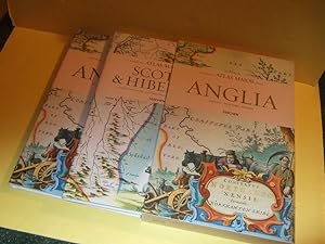
ANGLIA: TWO BOOKS in SLIPCASE: ATLAS MAIOR of 1665: England / Angleterre (volume 1 ) -with Scotia & Hibernia ( Scotland & Ireland / L'Ecosses et L'Irlande / Schottland Und Irland )(vol. 2 / Taschen Books (Text in German French / English )( All 113 Maps)
Edité par Cologne / Koln ( Germany ): Taschen Books, 2006, 1st Taschen Edition, First Printing, Cologne, Germany, 2006
ISBN 10 : 3822851043ISBN 13 : 9783822851043
Livre Edition originale
Hardcovers. Etat : Fine (see description). Etat de la jaquette : Fine (see description). Map Cover Art (illustrateur). First Edition. ------------TWO VOLUMES in SLIPCASE (ONE SHIPPING CHARGE), hardcovers, both are Fine examples, in Fine dustjackets, as NEW, obviously unread, ---both volumes are housed in a lightly rubbed near Fine matching slipcase ---unpaginated (likely about 200-250 pages in the two volumes) colour maps throughout, all text is in English, German and French, extra shipping might be required depending upon destination ---if an issue please inquire before ordering, ---"Maps of England, Ireland, and Scotland from Joan Blaeu's exquisite world atlas of 1665 The finest and most comprehensive baroque atlas was Joan Blaeu's exceptional Atlas Maior, completed in 1665. The original eleven-volume Latin edition, containing 594 maps, put Blaeu ahead of his staunch competitor, mapmaker Joanes Janssonius, whose rivalry inspired Blaeu to produce a grandiose edition of the largest and most complete atlas to date. Covering Arctica, Europe, Africa, Asia, and America, Blaeu's Atlas Maior was a remarkable achievement and remains to this day one of history's finest examples of mapmaking. This reprint, including all 58 maps of England and 55 maps of Scotland and Ireland, is made from the National Library of Vienna's colored, gold-heightened copy, thus assuring the best possible detail and quality. Alongside original quotes from Joan Blaeu relating to the individual maps, the new text by Peter van der Krogt explains the historical and cultural associations and introduces the reader into the fascinating world of early modern cartography. The text is in English, French and German. The author: Peter van der Krogt, the leading expert in the field of Dutch atlases, is a collaborator on the Explokart Research Program for the History of Cartography at the University of Utrecht's Faculty of Geosciences. Since 1990 he has been working on Koeman's Atlantes Neerlandici, the carto-bibliography of atlases published in the Netherlands. His second project is the compilation, in co-operation with the Nijmegen University, of an illustrated and annotated catalogue of the Atlas Blaeu-Van der Hem, the most important multi-volume atlas preserved in the Austrian National Library"---, any image directly beside this listing is the actual book and not a generic photo ///NOT SIGNED --GUARANTEED to be AVAILABLE/// ---sizes are approximate (generally within 1/8 inch)--- Size: 10.25w x 15.5h Inches. Not Signed. Flaps Not Clipped.
-
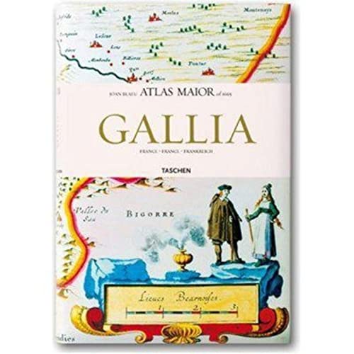
Atlas Maior - Francia
Edité par TASCHEN, 2006
ISBN 10 : 3822851051ISBN 13 : 9783822851050
Vendeur : Lexington Books Inc, Idaho Falls, ID, Etats-Unis
Evaluation du vendeur :
Livre
hardcover. Etat : Very Good.
-

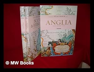
Atlas maior of 1665 / Joan Blaeu ; introduction and texts by Peter van der Krogt ; based on the copy in the Osterreichische Nationalbibliothek, Wien ; with a selection of original texts by Joan Blaeu ; directed and produced by Benedikt Taschen
Edité par Hong Kong ; London : Taschen, 2006
Edition originale
First Edition. Fine copy in the original gilt-blocked cloth boards in a slightly worn slip-case. Particularly and surprisingly well-preserved; tight, bright, clean and especially sharp-cornered. Physical description; 2 v. (392 p.) : ill. (chiefly col., col. maps, col. ports.) ; 39 cm. Notes; In slip case. "All 113 maps of England, Scotland and Ireland, and the original commentaries from Joan Blaeu's Atlas maior of 1665, 'the greatest and finest atlas ever published.'". Includes bibliographical references and index. Contents; Incomplete contents v. 1. Anglia = England -- v. 2. Scotia & Hibernia = Scotland and Ireland. Summary; This work contains maps of England, Ireland, and Scotland from Joan Blaeu's exquisite world atlas of 1665. "The Atlas Maior", the cartographical masterpiece of the Baroque period, was brought out between 1662 and 1665 by the Amsterdam publisher Joan Blaeu, one of Holland's leading cartographers. Originally appearing in Latin, the atlas comprised 594 maps in 11 volumes, which depicted the whole of the world as known to early modern Europe. It was the largest and most expensive book published during the 17th century. For more than 100 years, it remained the definitive atlas of the world, and today is among the most sought-after and valuable antiquarian rarities. This reprinted edition in six volumes is based on the hand-colored, gold-heightened copy in the "Osterreichische Nationalbibliothek" in Vienna, thus ensuring the best possible detail and quality. Alongside Joan Blaeu's original commentaries on the individual maps, a new text by Peter van der Krogt explains the historical and cultural associations and introduces the reader to the fascinating world of early modern cartography. This two-volume set features all 58 maps of England and 55 maps of Scotland and Ireland and the text is in English, French, and German. Subjects; Scales differ. England - Maps - Early works to 1800. Ireland - Maps - Early works to 1800. Scotland - Maps - Early works to 1800. Travel / road maps & atlases. Antiques & collectables: pictures, prints & maps. England ; Scotland ; Ireland. Reference / Atlases, Gazetteers & Maps. Technology & Engineering / Cartography. Technology & Engineering / History. 10 Kg.
-
Atlas maior of 1665 / Joan Blaeu ; introduction and texts by Peter van der Krogt ; based on the copy in the Osterreichische Nationalbibliothek, Wien ; with a selection of original texts by Joan Blaeu ; directed and produced by Benedikt Taschen
Edité par Hong Kong ; London : Taschen, 2006
Edition originale
First Edition. Fine copy in the original gilt-blocked cloth boards in a slightly worn slip-case. Particularly and surprisingly well-preserved; tight, bright, clean and especially sharp-cornered. Physical description; 2 v. (392 p.) : ill. (chiefly col., col. maps, col. ports.) ; 39 cm. Notes; In slip case. "All 113 maps of England, Scotland and Ireland, and the original commentaries from Joan Blaeu's Atlas maior of 1665, 'the greatest and finest atlas ever published.'". Includes bibliographical references and index. Contents; Incomplete contents v. 1. Anglia = England -- v. 2. Scotia & Hibernia = Scotland and Ireland. Summary; This work contains maps of England, Ireland, and Scotland from Joan Blaeu's exquisite world atlas of 1665. "The Atlas Maior", the cartographical masterpiece of the Baroque period, was brought out between 1662 and 1665 by the Amsterdam publisher Joan Blaeu, one of Holland's leading cartographers. Originally appearing in Latin, the atlas comprised 594 maps in 11 volumes, which depicted the whole of the world as known to early modern Europe. It was the largest and most expensive book published during the 17th century. For more than 100 years, it remained the definitive atlas of the world, and today is among the most sought-after and valuable antiquarian rarities. This reprinted edition in six volumes is based on the hand-colored, gold-heightened copy in the "Osterreichische Nationalbibliothek" in Vienna, thus ensuring the best possible detail and quality. Alongside Joan Blaeu's original commentaries on the individual maps, a new text by Peter van der Krogt explains the historical and cultural associations and introduces the reader to the fascinating world of early modern cartography. This two-volume set features all 58 maps of England and 55 maps of Scotland and Ireland and the text is in English, French, and German. Subjects; Scales differ. England - Maps - Early works to 1800. Ireland - Maps - Early works to 1800. Scotland - Maps - Early works to 1800. Travel / road maps & atlases. Antiques & collectables: pictures, prints & maps. England ; Scotland ; Ireland. Reference / Atlases, Gazetteers & Maps. Technology & Engineering / Cartography. Technology & Engineering / History. 10 Kg.