
Montant total (1 article articles) :
Destination de la commande :

bonne rigobert paris (75 résultats)
Passer aux résultats principaux de la recherche
Type d'article
- Tous les types d'articles
- Livres (70)
- Magazines & Périodiques
- Bandes dessinées
- Partitions de musique
- Art, Affiches et Gravures (1)
- Photographies
- Cartes (4)
-
Manuscrits &
Papiers anciens
Etat
- Tous
- Neuf
- Ancien ou d'occasion
Reliure
Particularités
- Edition originale
- Signé
- Jaquette
- Avec images
- Sans impression ŕ la demande
Pays
Evaluation du vendeur
-
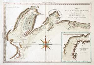
Carte de la River de Cook, dans la partie N.O. de L Amerique.
Edité par Artist: Bonne Rigobert ( - 1795 ) Paris ; issued in: Paris ; ca: 1760; - Rigobert Bonne (1727?1795) was one of the most important cartographers of the late 18th century In 1773 Bonne succeeded Jacques Nicolas Bellin as Royal Cartographer to France in the office of the Hydrographer at the Depôt de la Marine Working in his official capacity Bonne compiled some of the most detailed and accurate maps of the period Bonne?s work represents an important step in the evolution of the cartographic ideology away from the decorative work of the 17th and early 18th century towards a more detail oriented and practical aesthetic With regard to the rendering of terrain Bonne maps bear many stylistic similarities to those of his predecessor Bellin However B, 1727
Vendeur : Antique Sommer& Sapunaru KG, München, Allemagne
Membre d'association : ILAB VDA
Evaluation du vendeur :

Technic: Copper print; colorit: original colored; condition: Perfect condition, size (in cm): 23,5 x 34,5 cm; - Map shows the norther coast of Canada with the river Cook and the island Montagu, inset map shows the map of the harbour of Samgano Odha in Alaska.
-
Carte de la Riviere de Cook, dans la partie N. O. de L'Amérique.
Edité par Artist: Bonne Rigobert ( - 1795 ) Paris ; issued in: Paris ; ca: 1778; - Rigobert Bonne (1727?1795) was one of the most important cartographers of the late 18th century In 1773 Bonne succeeded Jacques Nicolas Bellin as Royal Cartographer to France in the office of the Hydrographer at the Depôt de la Marine Working in his official capacity Bonne compiled some of the most detailed and accurate maps of the period Bonne?s work represents an important step in the evolution of the cartographic ideology away from the decorative work of the 17th and early 18th century towards a more detail oriented and practical aesthetic With regard to the rendering of terrain Bonne maps bear many stylistic similarities to those of his predecessor Bellin However B, 1727
Vendeur : Antique Sommer& Sapunaru KG, München, Allemagne
Membre d'association : ILAB VDA
Evaluation du vendeur :
Carte
Technic: Copper print; colorit: original colored; condition: Perfect condition, size (in cm): 23,5 x 30 cm; - Detailed map of Captain James Cook's route from Cape Suckling and Control Bay through Prince William Sound and past Mount St Augustine, Cape Douglass and Cape Grenville. Furthermore, it shows Cook Inlet in the Gulf of Alaska, separating the Kenai Peninsula from mainland Alaska.
-
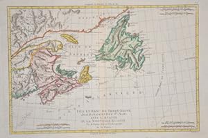
Isle et Banc de Terre- Neuve isle Royale et isle St. Jean avec l Acadie ou la nouvelle Ecosse
Edité par Artist: Bonne Rigobert ( - 1795 ) Paris ; issued in: Paris ; ca: 1755; - Rigobert Bonne (1727?1795) was one of the most important cartographers of the late 18th century In 1773 Bonne succeeded Jacques Nicolas Bellin as Royal Cartographer to France in the office of the Hydrographer at the Depôt de la Marine Working in his official capacity Bonne compiled some of the most detailed and accurate maps of the period Bonne?s work represents an important step in the evolution of the cartographic ideology away from the decorative work of the 17th and early 18th century towards a more detail oriented and practical aesthetic With regard to the rendering of terrain Bonne maps bear many stylistic similarities to those of his predecessor Bellin However B, 1727
Vendeur : Antique Sommer& Sapunaru KG, München, Allemagne
Membre d'association : ILAB VDA
Evaluation du vendeur :
Technic: Copper print; colorit: colored; condition: Very good, size (in cm): 23,5 x 34; - Map shows the east coast of Canada with.
-
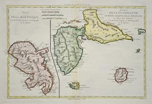
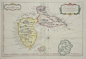
Isles de la Guadeloup/Isle de la Martinique
Edité par Artist: Bonne Rigobert ( - 1795 ) Paris ; issued in: Paris ; ca: 1780; - Rigobert Bonne (1727?1795) was one of the most important cartographers of the late 18th century In 1773 Bonne succeeded Jacques Nicolas Bellin as Royal Cartographer to France in the office of the Hydrographer at the Depôt de la Marine Working in his official capacity Bonne compiled some of the most detailed and accurate maps of the period Bonne?s work represents an important step in the evolution of the cartographic ideology away from the decorative work of the 17th and early 18th century towards a more detail oriented and practical aesthetic With regard to the rendering of terrain Bonne maps bear many stylistic similarities to those of his predecessor Bellin However B, 1727
Vendeur : Antique Sommer& Sapunaru KG, München, Allemagne
Membre d'association : ILAB VDA
Evaluation du vendeur :
Technic: Copper print; colorit: gouache; condition: Very good, size (in cm): 23 x 34; - Map shows the Islands of Guadeloupe and Martinique.
-

Les Treize Cantons de la Suisse, leurs Allies, les Sujets de ces Cantons, et ceux de leurs Allies.
Edité par Artist: Bonne Rigobert ( - 1795 ) Paris ; issued in: Paris ; ca: 1780; - Rigobert Bonne (1727?1795) was one of the most important cartographers of the late 18th century In 1773 Bonne succeeded Jacques Nicolas Bellin as Royal Cartographer to France in the office of the Hydrographer at the Depôt de la Marine Working in his official capacity Bonne compiled some of the most detailed and accurate maps of the period Bonne?s work represents an important step in the evolution of the cartographic ideology away from the decorative work of the 17th and early 18th century towards a more detail oriented and practical aesthetic With regard to the rendering of terrain Bonne maps bear many stylistic similarities to those of his predecessor Bellin However B, 1727
Vendeur : Antique Sommer& Sapunaru KG, München, Allemagne
Membre d'association : ILAB VDA
Evaluation du vendeur :
Technic: Copper print; colorit: colored; condition: Perfect condition, size (in cm): 24,5 x 34,5 cm; - Map shows the whole of Switzerland divided into cantons.
-

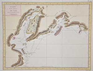
Carte de la Rivičre de Cook, dans la partie N.O. de L'Amérique.
Edité par Artist: Bonne Rigobert ( - 1795 ) Paris ; issued in: Paris ; ca: 1778; - Rigobert Bonne (1727?1795) was one of the most important cartographers of the late 18th century In 1773 Bonne succeeded Jacques Nicolas Bellin as Royal Cartographer to France in the office of the Hydrographer at the Depôt de la Marine Working in his official capacity Bonne compiled some of the most detailed and accurate maps of the period Bonne?s work represents an important step in the evolution of the cartographic ideology away from the decorative work of the 17th and early 18th century towards a more detail oriented and practical aesthetic With regard to the rendering of terrain Bonne maps bear many stylistic similarities to those of his predecessor Bellin However B, 1727
Vendeur : Antique Sommer& Sapunaru KG, München, Allemagne
Membre d'association : ILAB VDA
Evaluation du vendeur :
Carte
Technic: Copper print; colorit: colored; condition: Perfect condition, size (in cm): 23,5 x 34,5 cm; - Map shows Cook Inlet which stretches 180 miles (290 km) from the Gulf of Alaska to Anchorage in south-central Alaska.
-

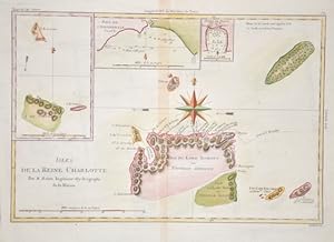
Isles de la Reine Charlotte.
Edité par Artist: Bonne Rigobert ( - 1795 ) Paris ; issued in: Paris ; ca: 1774; - Rigobert Bonne (1727?1795) was one of the most important cartographers of the late 18th century In 1773 Bonne succeeded Jacques Nicolas Bellin as Royal Cartographer to France in the office of the Hydrographer at the Depôt de la Marine Working in his official capacity Bonne compiled some of the most detailed and accurate maps of the period Bonne?s work represents an important step in the evolution of the cartographic ideology away from the decorative work of the 17th and early 18th century towards a more detail oriented and practical aesthetic With regard to the rendering of terrain Bonne maps bear many stylistic similarities to those of his predecessor Bellin However B, 1727
Vendeur : Antique Sommer& Sapunaru KG, München, Allemagne
Membre d'association : ILAB VDA
Evaluation du vendeur :
Technic: Copper print; colorit: colored; condition: Perfect condition, size (in cm): 23,5 x 34 cm; - Map shows the islands Haida Gwaii (until 2009 officiallyl Queen Charlotte Islands) at the British Columbia coast in the Pacific Ocean, Kanada. On two inset maps showing, de Carteret; Baye de l'Hirondelle.; Havre de Byron.
-

Les royaumes de Suede, de Danemark et de Norvege
Edité par Artist: Bonne Rigobert ( - 1795 ) Paris ; issued in: Paris ; ca: 1780; - Rigobert Bonne (1727?1795) was one of the most important cartographers of the late 18th century In 1773 Bonne succeeded Jacques Nicolas Bellin as Royal Cartographer to France in the office of the Hydrographer at the Depôt de la Marine Working in his official capacity Bonne compiled some of the most detailed and accurate maps of the period Bonne?s work represents an important step in the evolution of the cartographic ideology away from the decorative work of the 17th and early 18th century towards a more detail oriented and practical aesthetic With regard to the rendering of terrain Bonne maps bear many stylistic similarities to those of his predecessor Bellin However B, 1727
Vendeur : Antique Sommer& Sapunaru KG, München, Allemagne
Membre d'association : ILAB VDA
Evaluation du vendeur :
Technic: Copper print; colorit: original colored; condition: Very good, size (in cm): 34 x 23; - Map shows total Scandinavia with Sweden, Denmark and Norway.
-
Carte de l Isle de la Guadelup
Edité par Artist: Bonne Rigobert ( - 1795 ) Paris ; issued in: Paris ; dated: 1758; - Rigobert Bonne (1727?1795) was one of the most important cartographers of the late 18th century In 1773 Bonne succeeded Jacques Nicolas Bellin as Royal Cartographer to France in the office of the Hydrographer at the Depôt de la Marine Working in his official capacity Bonne compiled some of the most detailed and accurate maps of the period Bonne?s work represents an important step in the evolution of the cartographic ideology away from the decorative work of the 17th and early 18th century towards a more detail oriented and practical aesthetic With regard to the rendering of terrain Bonne maps bear many stylistic similarities to those of his predecessor Bellin Howeve, 1727
Vendeur : Antique Sommer& Sapunaru KG, München, Allemagne
Membre d'association : ILAB VDA
Evaluation du vendeur :
Technic: Copper print; colorit: colored; condition: Very good, size (in cm): 20 x 30; - Map shows the island of Guadeloupe.
-

Royaume de Prusse
Edité par Artist: Bonne Rigobert ( - 1795 ) Paris ; issued in: Paris ; ca: 1750; - Rigobert Bonne (1727?1795) was one of the most important cartographers of the late 18th century In 1773 Bonne succeeded Jacques Nicolas Bellin as Royal Cartographer to France in the office of the Hydrographer at the Depôt de la Marine Working in his official capacity Bonne compiled some of the most detailed and accurate maps of the period Bonne?s work represents an important step in the evolution of the cartographic ideology away from the decorative work of the 17th and early 18th century towards a more detail oriented and practical aesthetic With regard to the rendering of terrain Bonne maps bear many stylistic similarities to those of his predecessor Bellin However B, 1727
Vendeur : Antique Sommer& Sapunaru KG, München, Allemagne
Membre d'association : ILAB VDA
Evaluation du vendeur :
Technic: Copper print; colorit: colored; condition: Perfect condition, size (in cm): 23 x 34; - Decorativ map depicts Prussia in general.
-
Isles de la Reine Charlotte.
Edité par Artist: Bonne Rigobert ( - 1795 ) Paris ; issued in: Paris ; ca: 1780; - Rigobert Bonne (1727?1795) was one of the most important cartographers of the late 18th century In 1773 Bonne succeeded Jacques Nicolas Bellin as Royal Cartographer to France in the office of the Hydrographer at the Depôt de la Marine Working in his official capacity Bonne compiled some of the most detailed and accurate maps of the period Bonne?s work represents an important step in the evolution of the cartographic ideology away from the decorative work of the 17th and early 18th century towards a more detail oriented and practical aesthetic With regard to the rendering of terrain Bonne maps bear many stylistic similarities to those of his predecessor Bellin However B, 1727
Vendeur : Antique Sommer& Sapunaru KG, München, Allemagne
Membre d'association : ILAB VDA
Evaluation du vendeur :
Technic: Copper print; colorit: original colored; condition: Perfect condition, size (in cm): 23,5 x 34 cm; - Map shows the Solomon Islands in the Pacific and three partial maps.
-
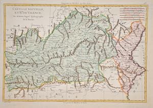
Castille nouvelle, et rme. de Valence.
Edité par Artist: Bonne Rigobert ( - 1795 ) Paris ; issued in: Paris ; ca: 1750; - Rigobert Bonne (1727?1795) was one of the most important cartographers of the late 18th century In 1773 Bonne succeeded Jacques Nicolas Bellin as Royal Cartographer to France in the office of the Hydrographer at the Depôt de la Marine Working in his official capacity Bonne compiled some of the most detailed and accurate maps of the period Bonne?s work represents an important step in the evolution of the cartographic ideology away from the decorative work of the 17th and early 18th century towards a more detail oriented and practical aesthetic With regard to the rendering of terrain Bonne maps bear many stylistic similarities to those of his predecessor Bellin However B, 1727
Vendeur : Antique Sommer& Sapunaru KG, München, Allemagne
Membre d'association : ILAB VDA
Evaluation du vendeur :
Technic: Copper print; colorit: original colored; condition: Perfect condition, size (in cm): 23 x 34 cm; - Map shows total Valencia, Murcia, La Manchia, Estremadura and New Castilia.
-

Detroit de Magellan avec les Plans des Principaux Ports, Bays & de ce Detroits
Edité par Artist: Bonne Rigobert ( - 1795 ) Paris ; issued in: Paris ; ca: 1740; - Rigobert Bonne (1727?1795) was one of the most important cartographers of the late 18th century In 1773 Bonne succeeded Jacques Nicolas Bellin as Royal Cartographer to France in the office of the Hydrographer at the Depôt de la Marine Working in his official capacity Bonne compiled some of the most detailed and accurate maps of the period Bonne?s work represents an important step in the evolution of the cartographic ideology away from the decorative work of the 17th and early 18th century towards a more detail oriented and practical aesthetic With regard to the rendering of terrain Bonne maps bear many stylistic similarities to those of his predecessor Bellin However B, 1727
Vendeur : Antique Sommer& Sapunaru KG, München, Allemagne
Membre d'association : ILAB VDA
Evaluation du vendeur :
Technic: Copper print; colorit: original colored; condition: Very good, size (in cm): 23 x 34; - Map shows the Street of Magellan with 16 small inset maps showing different harbours and bays.
-
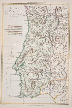
Royaume de Portugal.
Edité par Artist: Bonne Rigobert ( - 1795 ) Paris ; issued in: Paris ; ca: 1780; - Rigobert Bonne (1727?1795) was one of the most important cartographers of the late 18th century In 1773 Bonne succeeded Jacques Nicolas Bellin as Royal Cartographer to France in the office of the Hydrographer at the Depôt de la Marine Working in his official capacity Bonne compiled some of the most detailed and accurate maps of the period Bonne?s work represents an important step in the evolution of the cartographic ideology away from the decorative work of the 17th and early 18th century towards a more detail oriented and practical aesthetic With regard to the rendering of terrain Bonne maps bear many stylistic similarities to those of his predecessor Bellin However B, 1727
Vendeur : Antique Sommer& Sapunaru KG, München, Allemagne
Membre d'association : ILAB VDA
Evaluation du vendeur :
Technic: Copper print; colorit: colored; condition: Perfect condition, size (in cm): 35,5 x 23 cm; - Map shows the whole of Portugal.
-
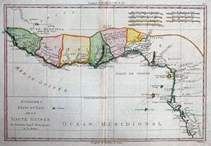
Royaume, Etats et Pays de la haute Guinée
Edité par Artist: Bonne Rigobert ( - 1795 ) Paris ; issued in: Paris ; ca: 1780; - Rigobert Bonne (1727?1795) was one of the most important cartographers of the late 18th century In 1773 Bonne succeeded Jacques Nicolas Bellin as Royal Cartographer to France in the office of the Hydrographer at the Depôt de la Marine Working in his official capacity Bonne compiled some of the most detailed and accurate maps of the period Bonne?s work represents an important step in the evolution of the cartographic ideology away from the decorative work of the 17th and early 18th century towards a more detail oriented and practical aesthetic With regard to the rendering of terrain Bonne maps bear many stylistic similarities to those of his predecessor Bellin However B, 1727
Vendeur : Antique Sommer& Sapunaru KG, München, Allemagne
Membre d'association : ILAB VDA
Evaluation du vendeur :
Technic: Copper print; colorit: original colored; condition: Very good, size (in cm): 24 x 34; - Map shows the Gulf of Guinea with the countries Sierra Leone, Liberia, Ivory Coast, Ghana, Togo, Benin and Nigeria in Africa.
-
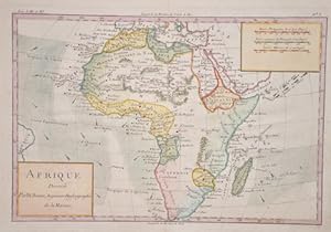
Afrique Dressee
Edité par Artist: Bonne Rigobert ( - 1795 ) Paris ; issued in: Paris ; ca: 1770; - Rigobert Bonne (1727?1795) was one of the most important cartographers of the late 18th century In 1773 Bonne succeeded Jacques Nicolas Bellin as Royal Cartographer to France in the office of the Hydrographer at the Depôt de la Marine Working in his official capacity Bonne compiled some of the most detailed and accurate maps of the period Bonne?s work represents an important step in the evolution of the cartographic ideology away from the decorative work of the 17th and early 18th century towards a more detail oriented and practical aesthetic With regard to the rendering of terrain Bonne maps bear many stylistic similarities to those of his predecessor Bellin However B, 1727
Vendeur : Antique Sommer& Sapunaru KG, München, Allemagne
Membre d'association : ILAB VDA
Evaluation du vendeur :
Technic: Copper print; colorit: colored; condition: Perfect condition, size (in cm): 21,5 x 32; - Map shows the continent of Africa.
-
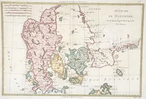
Rňyaume de Danemark.
Edité par Artist: Bonne Rigobert ( - 1795 ) Paris ; issued in: Paris ; ca: 1780; - Rigobert Bonne (1727?1795) was one of the most important cartographers of the late 18th century In 1773 Bonne succeeded Jacques Nicolas Bellin as Royal Cartographer to France in the office of the Hydrographer at the Depôt de la Marine Working in his official capacity Bonne compiled some of the most detailed and accurate maps of the period Bonne?s work represents an important step in the evolution of the cartographic ideology away from the decorative work of the 17th and early 18th century towards a more detail oriented and practical aesthetic With regard to the rendering of terrain Bonne maps bear many stylistic similarities to those of his predecessor Bellin However B, 1727
Vendeur : Antique Sommer& Sapunaru KG, München, Allemagne
Membre d'association : ILAB VDA
Evaluation du vendeur :
Technic: Copper print; colorit: original colored; condition: Perfect condition, size (in cm): 24 x 34,5; - Map shows total Denmark with Jutland, Funen, Zealand, Lolland-Falster, Bornholm, etc. and the traditional provinces of Sweden Halland, Scania, Blekinge and the Dutsch of Holstein it's was the northernmost state of the Holy Roman Empire, located in the present German state of Schleswig-Holstein. Denmark officially the Kingdom of Denmark, is a Nordic country and a sovereign state. The southernmost of the Scandinavian nations, it is south-west of Sweden and south of Norway,and bordered to the south by Germany. The tribal Danes came from the east Danish islands (Zealand) and Scania and spoke an early form of North Germanic. Historians believe that before their arrival, most of Jutland and the nearest islands were settled by tribal Jutes.
-

Isles de la Reine Charlotte
Edité par Artist: Bonne Rigobert ( - 1795 ) Paris ; issued in: Paris ; ca: 1750; - Rigobert Bonne (1727?1795) was one of the most important cartographers of the late 18th century In 1773 Bonne succeeded Jacques Nicolas Bellin as Royal Cartographer to France in the office of the Hydrographer at the Depôt de la Marine Working in his official capacity Bonne compiled some of the most detailed and accurate maps of the period Bonne?s work represents an important step in the evolution of the cartographic ideology away from the decorative work of the 17th and early 18th century towards a more detail oriented and practical aesthetic With regard to the rendering of terrain Bonne maps bear many stylistic similarities to those of his predecessor Bellin However B, 1727
Vendeur : Antique Sommer& Sapunaru KG, München, Allemagne
Membre d'association : ILAB VDA
Evaluation du vendeur :
Technic: Copper print; colorit: colored; condition: Very good, size (in cm): 24 x 34,5; - Map shows the Queen Charlotte Islands, Haida Gwaii, at Brittish Columbia.
-

Carte Du Canal De Mosambique, Contenant L Isle De Madagascar Avec Les Cotes D Afrique
Edité par Artist: Bonne Rigobert ( - 1795 ) Paris ; issued in: Paris ; ca: 1780; - Rigobert Bonne (1727?1795) was one of the most important cartographers of the late 18th century In 1773 Bonne succeeded Jacques Nicolas Bellin as Royal Cartographer to France in the office of the Hydrographer at the Depôt de la Marine Working in his official capacity Bonne compiled some of the most detailed and accurate maps of the period Bonne?s work represents an important step in the evolution of the cartographic ideology away from the decorative work of the 17th and early 18th century towards a more detail oriented and practical aesthetic With regard to the rendering of terrain Bonne maps bear many stylistic similarities to those of his predecessor Bellin However B, 1727
Vendeur : Antique Sommer& Sapunaru KG, München, Allemagne
Membre d'association : ILAB VDA
Evaluation du vendeur :
Technic: Copper print; colorit: colored; condition: Very good, size (in cm): 22 x 32; - Map shows the south eastern coast of Africa from Mombasa to Cape of good Hope with Madagascar and the Mascarenian islands ( Mauritius, Reunion, Seychelle),on seperate map St. Helena and St. Helena bay.
-
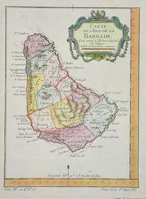
Carte de l`isle de la Barbade
Edité par Artist: Bonne Rigobert ( - 1795 ) Paris ; issued in: Paris ; ca: 1760; - Rigobert Bonne (1727?1795) was one of the most important cartographers of the late 18th century In 1773 Bonne succeeded Jacques Nicolas Bellin as Royal Cartographer to France in the office of the Hydrographer at the Depôt de la Marine Working in his official capacity Bonne compiled some of the most detailed and accurate maps of the period Bonne?s work represents an important step in the evolution of the cartographic ideology away from the decorative work of the 17th and early 18th century towards a more detail oriented and practical aesthetic With regard to the rendering of terrain Bonne maps bear many stylistic similarities to those of his predecessor Bellin However B, 1727
Vendeur : Antique Sommer& Sapunaru KG, München, Allemagne
Membre d'association : ILAB VDA
Evaluation du vendeur :
Technic: Copper print; colorit: colored; condition: Very good, size (in cm): 20 x 15; - Map sows the Islend of Barbados.
-

Carte des regions et des lieux dont il est parlé dans le Nouveau Testament
Edité par Artist: Bonne Rigobert ( - 1795 ) Paris ; issued in: Paris ; ca: 1750; - Rigobert Bonne (1727?1795) was one of the most important cartographers of the late 18th century In 1773 Bonne succeeded Jacques Nicolas Bellin as Royal Cartographer to France in the office of the Hydrographer at the Depôt de la Marine Working in his official capacity Bonne compiled some of the most detailed and accurate maps of the period Bonne?s work represents an important step in the evolution of the cartographic ideology away from the decorative work of the 17th and early 18th century towards a more detail oriented and practical aesthetic With regard to the rendering of terrain Bonne maps bear many stylistic similarities to those of his predecessor Bellin However B, 1727
Vendeur : Antique Sommer& Sapunaru KG, München, Allemagne
Membre d'association : ILAB VDA
Evaluation du vendeur :
Technic: Copper print; colorit: original colored; condition: Perfect condition, size (in cm): 30,5 x 44,5 cm; - Map shows Asia Minor with two partial maps, the city map of Jerusalem and Terra Sancta. Furthermore, a total of three cartouches and an index.
-
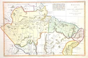
Bresil et Pays des Amazones. Ire. Feuille.
Edité par Artist: Bonne Rigobert ( - 1795 ) Paris ; issued in: Paris ; ca: 1789; - Rigobert Bonne (1727?1795) was one of the most important cartographers of the late 18th century In 1773 Bonne succeeded Jacques Nicolas Bellin as Royal Cartographer to France in the office of the Hydrographer at the Depôt de la Marine Working in his official capacity Bonne compiled some of the most detailed and accurate maps of the period Bonne?s work represents an important step in the evolution of the cartographic ideology away from the decorative work of the 17th and early 18th century towards a more detail oriented and practical aesthetic With regard to the rendering of terrain Bonne maps bear many stylistic similarities to those of his predecessor Bellin However B, 1727
Vendeur : Antique Sommer& Sapunaru KG, München, Allemagne
Membre d'association : ILAB VDA
Evaluation du vendeur :
Technic: Copper print; colorit: original colored; condition: Perfect condition, size (in cm): 23,5 x 36,5 cm; - Map shows the northern part of Brazil with the Amazon and the coast from Cayenne to Salvador. A large watermark with coat of arms and a crown over the entire sheet.
-
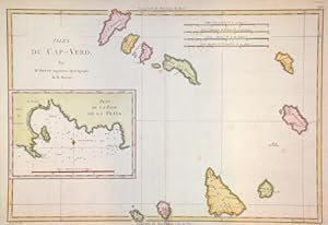
Isles du Cap- Verd. / Plan de la Rade De la Praya
Edité par Artist: Bonne Rigobert ( - 1795 ) Paris ; issued in: Paris ; ca: 1780; - Rigobert Bonne (1727?1795) was one of the most important cartographers of the late 18th century In 1773 Bonne succeeded Jacques Nicolas Bellin as Royal Cartographer to France in the office of the Hydrographer at the Depôt de la Marine Working in his official capacity Bonne compiled some of the most detailed and accurate maps of the period Bonne?s work represents an important step in the evolution of the cartographic ideology away from the decorative work of the 17th and early 18th century towards a more detail oriented and practical aesthetic With regard to the rendering of terrain Bonne maps bear many stylistic similarities to those of his predecessor Bellin However B, 1727
Vendeur : Antique Sommer& Sapunaru KG, München, Allemagne
Membre d'association : ILAB VDA
Evaluation du vendeur :
Technic: Copper print; colorit: original colored; condition: Very good, size (in cm): 24 x 34,5 cm; - Map shows the Cape Verde Islands, one inset map shows the bay of La Praa.
-
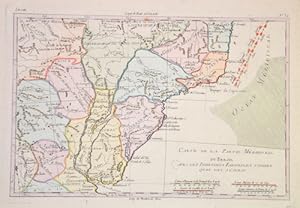
Carte de la partie merdional du Bresil
Edité par Artist: Bonne Rigobert ( - 1795 ) Paris ; issued in: Paris ; ca: 1775; - Rigobert Bonne (1727?1795) was one of the most important cartographers of the late 18th century In 1773 Bonne succeeded Jacques Nicolas Bellin as Royal Cartographer to France in the office of the Hydrographer at the Depôt de la Marine Working in his official capacity Bonne compiled some of the most detailed and accurate maps of the period Bonne?s work represents an important step in the evolution of the cartographic ideology away from the decorative work of the 17th and early 18th century towards a more detail oriented and practical aesthetic With regard to the rendering of terrain Bonne maps bear many stylistic similarities to those of his predecessor Bellin However B, 1727
Vendeur : Antique Sommer& Sapunaru KG, München, Allemagne
Membre d'association : ILAB VDA
Evaluation du vendeur :
Technic: Copper print; colorit: colored; condition: Perfect condition, size (in cm): 21 x 31 cm; - Map shows the south part of Brasil.
-
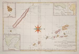
Isles des Nouvelles Hebrides, et celle de la nouvelle Caledonie
Edité par Artist: Bonne Rigobert ( - 1795 ) Paris ; issued in: Paris ; ca: 1771; - Rigobert Bonne (1727?1795) was one of the most important cartographers of the late 18th century In 1773 Bonne succeeded Jacques Nicolas Bellin as Royal Cartographer to France in the office of the Hydrographer at the Depôt de la Marine Working in his official capacity Bonne compiled some of the most detailed and accurate maps of the period Bonne?s work represents an important step in the evolution of the cartographic ideology away from the decorative work of the 17th and early 18th century towards a more detail oriented and practical aesthetic With regard to the rendering of terrain Bonne maps bear many stylistic similarities to those of his predecessor Bellin However B, 1727
Vendeur : Antique Sommer& Sapunaru KG, München, Allemagne
Membre d'association : ILAB VDA
Evaluation du vendeur :
Technic: Copper print; colorit: colored; condition: Very good, size (in cm): 23 x 34; - Map shows the New Hebrides and New Caledonia located in the southwest Pacific Ocean.
-
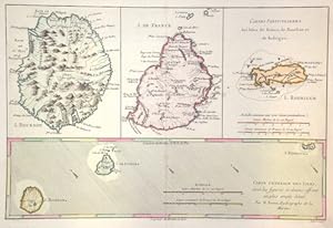
Cartes Generale et Particulieres des Isles de France, de Bourbon et de Rodrigue.
Edité par Artist: Bonne Rigobert ( - 1795 ) Paris ; issued in: Paris ; ca: 1779; - Rigobert Bonne (1727?1795) was one of the most important cartographers of the late 18th century In 1773 Bonne succeeded Jacques Nicolas Bellin as Royal Cartographer to France in the office of the Hydrographer at the Depôt de la Marine Working in his official capacity Bonne compiled some of the most detailed and accurate maps of the period Bonne?s work represents an important step in the evolution of the cartographic ideology away from the decorative work of the 17th and early 18th century towards a more detail oriented and practical aesthetic With regard to the rendering of terrain Bonne maps bear many stylistic similarities to those of his predecessor Bellin However B, 1727
Vendeur : Antique Sommer& Sapunaru KG, München, Allemagne
Membre d'association : ILAB VDA
Evaluation du vendeur :
Technic: Copper print; colorit: original colored; condition: Perfect condition, size (in cm): 21,5 x 32 cm; - Map shows the island of Mauritius and the island of La Réunion. Furthermore, three additional partial maps of the island of La Réunion, Mauritius and the island of Rodrigues in the Indian Ocean.
-
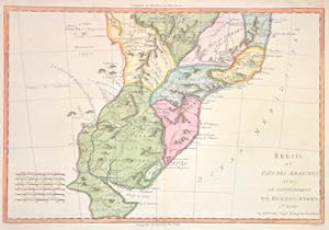
Brésil et Pays des Amazones, avec le Gouvernement de Buenos-Ayres.
Edité par Artist: Bonne Rigobert ( - 1795 ) Paris ; issued in: Paris ; ca: 1780; - Rigobert Bonne (1727?1795) was one of the most important cartographers of the late 18th century In 1773 Bonne succeeded Jacques Nicolas Bellin as Royal Cartographer to France in the office of the Hydrographer at the Depôt de la Marine Working in his official capacity Bonne compiled some of the most detailed and accurate maps of the period Bonne?s work represents an important step in the evolution of the cartographic ideology away from the decorative work of the 17th and early 18th century towards a more detail oriented and practical aesthetic With regard to the rendering of terrain Bonne maps bear many stylistic similarities to those of his predecessor Bellin However B, 1727
Vendeur : Antique Sommer& Sapunaru KG, München, Allemagne
Membre d'association : ILAB VDA
Evaluation du vendeur :
Technic: Copper print; colorit: original colored; condition: Perfect condition, size (in cm): 24 x 34,5 cm; - Map depicts the southern part of Brasil with Buenos Aires at Rio de la Plata, Montevideio, Rio de Janairo, etc.
-
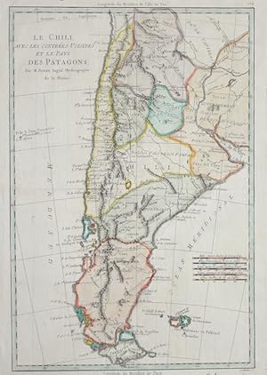
Le Chili, avec les contrées Voisines et le Pays des Patagons.
Edité par Artist: Bonne Rigobert ( - 1795 ) Paris ; issued in: Paris ; ca: 1750; - Rigobert Bonne (1727?1795) was one of the most important cartographers of the late 18th century In 1773 Bonne succeeded Jacques Nicolas Bellin as Royal Cartographer to France in the office of the Hydrographer at the Depôt de la Marine Working in his official capacity Bonne compiled some of the most detailed and accurate maps of the period Bonne?s work represents an important step in the evolution of the cartographic ideology away from the decorative work of the 17th and early 18th century towards a more detail oriented and practical aesthetic With regard to the rendering of terrain Bonne maps bear many stylistic similarities to those of his predecessor Bellin However B, 1727
Vendeur : Antique Sommer& Sapunaru KG, München, Allemagne
Membre d'association : ILAB VDA
Evaluation du vendeur :
Technic: Copper print; colorit: colored; condition: Perfect condition, size (in cm): 35 x 23 cm; - Map shows all of Chile, Argentina, Paraguay, Tierra del Fuego, partly Brazil and a title cartouche.
-
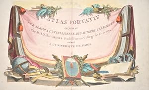
Atlas Portatif General Pour servir a l'intelligence des Auteurs Classiques par M. L'Abbe Grenet.
Edité par Artist: Bonne Rigobert ( - 1795 ) Paris ; issued in: Paris ; ca: 1793; - Rigobert Bonne (1727?1795) was one of the most important cartographers of the late 18th century In 1773 Bonne succeeded Jacques Nicolas Bellin as Royal Cartographer to France in the office of the Hydrographer at the Depôt de la Marine Working in his official capacity Bonne compiled some of the most detailed and accurate maps of the period Bonne?s work represents an important step in the evolution of the cartographic ideology away from the decorative work of the 17th and early 18th century towards a more detail oriented and practical aesthetic With regard to the rendering of terrain Bonne maps bear many stylistic similarities to those of his predecessor Bellin However B, 1727
Vendeur : Antique Sommer& Sapunaru KG, München, Allemagne
Membre d'association : ILAB VDA
Evaluation du vendeur :
Art / Affiche / Gravure
Technic: Copper print; colorit: colored; condition: Margin outside, top slightly spotted, size (in cm): 23 x 31,5 cm; - Title page from "Atlas Portatif General Pour servir a l'intelligence des Auteurs Classiques par M. L'Abbe Grenet Professeur au College de Lisieux. Dedie a l'Universite de Paris". Authors: Grenet Abbe and Rigobert Bonne. French edition.
-
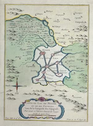
Carte du Lac de Mexico
Edité par Artist: Bonne Rigobert ( - 1795 ) Paris ; issued in: Paris ; ca: 1750; - Rigobert Bonne (1727?1795) was one of the most important cartographers of the late 18th century In 1773 Bonne succeeded Jacques Nicolas Bellin as Royal Cartographer to France in the office of the Hydrographer at the Depôt de la Marine Working in his official capacity Bonne compiled some of the most detailed and accurate maps of the period Bonne?s work represents an important step in the evolution of the cartographic ideology away from the decorative work of the 17th and early 18th century towards a more detail oriented and practical aesthetic With regard to the rendering of terrain Bonne maps bear many stylistic similarities to those of his predecessor Bellin However B, 1727
Vendeur : Antique Sommer& Sapunaru KG, München, Allemagne
Membre d'association : ILAB VDA
Evaluation du vendeur :
Technic: Copper print; colorit: colored; condition: Very good, size (in cm): 21 x 15; - Map shows Mexico City.