Montant total (1 article articles) :
Destination de la commande :

covens mortier (167 résultats)
Passer aux résultats principaux de la recherche
Type d'article
- Tous les types d'articles
- Livres (71)
- Magazines & Périodiques
- Bandes dessinées
- Partitions de musique
- Art, Affiches et Gravures (38)
- Photographies
- Cartes (58)
-
Manuscrits &
Papiers anciens
Etat
- Tous
- Neuf
- Ancien ou d'occasion
Reliure
Particularités
- Edition originale (3)
- Signé (1)
- Jaquette (2)
- Avec images (149)
- Sans impression ŕ la demande
Pays
Evaluation du vendeur
-
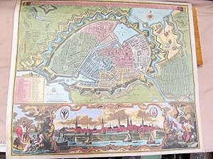
Hambourg, fameuse ville imperiale . Hamburg, eine weltberühmte Freye Reichs und Hansee auch reiche und Volkreiche Handels Stadt an der Elb., nicht weit von der Nord See. ( Nachdruck - Offsetdruck ).
Vendeur : Antiquariat Friederichsen, Hamburg, Allemagne
Membre d'association : BOEV
Evaluation du vendeur :

Art / Affiche / Gravure
Große Planansicht von Hamburg als undatierter Nachdruck mit den Befestigungen aus der Vogelschau, mit französisch-deutschem Titel in Schriftband im oberen Rand der Darstellung. Mit Meilenzeiger und Windrose. Im unteren Drittel des Blattes eine Schmuckkartusche mit einer Gesamtansicht der Stadt mit ihren Kirchtürmen von der Elbe aus, rechts und links davon allegorisch-figürliches Beiwerk, links mittig eine umfangreiche Bildlegende mit 53 Positionen sowie Angabe der Einteilung der Stadt in Alt- und Neustadt und nach den Kirchspielen. Das detailreiche Blatt zeigt in etwa die Gegend von der Mitte der Außenalster über die Binnenalster und das befestigte Stadtgebiet bis hinunter zum Hafen, der Elbe und bis zum Grasbrook, linkerhand außen die *Rehper-Bahn* ( Reeperbahn ), rechterhand außen die Vogelstange und das Lübsche Thor. Das Blatt mit Mittelfalz, 2 Querfalzen und 2 Falzen zu den Außenrändern hin. Der Offsetdruck an den Falzrändern gering berieben, das Blatt ist mehrfach gefaltet, ansonsten von recht guter Erhaltung. ( Pic erhältlich // webimage available ).
-
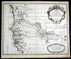
Carte de l Afrique Francoise ou du Senegal" - Senegal Gambia West Africa map Karte Covens Mortier engraving
Edité par Amsterdam, Covens & Mortier um 1730., 1730
Vendeur : Antiquariat Steffen Völkel GmbH, Seubersdorf, Allemagne
Membre d'association : ILAB VDA
Evaluation du vendeur :
Carte
original altkolorierte Kupferstich-Karte von ca. 1730 - Blattformat: ca. 65 x 54 cm - gut erhalten. | original hand-colored copper engraved map from circa 1730 - size of sheet: circa 25.6 x 21.3 inches - good condition. Sprache: Deutsch Gewicht in Gramm: 1500.
-

Etat : -. Handkolorierter Kupferstich. Blatt 55 x 65 cm. Mittig außerhalb der Karte mit Gewebeband repariert. Schönes Blatt.
-
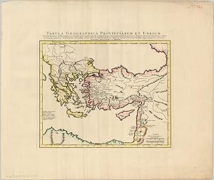
Tabula Geographica Prvinciarum et Urbium Gorgeous re-issue of Delisle's map of the Eastern Roman Empire.
Date d'édition : 1725
Vendeur : Curtis Wright Maps, Berwyn, IL, Etats-Unis
Membre d'association : ESA MWABA
Evaluation du vendeur :

Etat : Fine. This eye catching copperplate engraved map covers portions of Greece and Asia Minor, and was published by Covens & Mortier in Amsterdam in 1725. It's based on an earlier issue by the influential French cartographer Guillame Delisle, who is duly credited in the title block. The map presents a historical account of the eastern portion of the Roman Empire (it had not yet split), apparently during the rule of Emperor Trajan (c. 110 AD). Trajan presided over a number of successful campaigns in the region during his reign, which saw the empire reach its maximum territorial expansion. Sheet Width (in) 25.5 Sheet Height (in) 21.5 Condition Description Slight waviness to the sheet and a bit of extraneous vertical creasing. Creased upper right corner, one small spot in the Black Sea, and one small spot near the scale. The map has a dark impression and bright hand color that really makes it pop from the sheet. Fine watermarked paper with wide margins. Near fine condition overall.
-
Diocese of Toul, Lorraine, anno 1745, map by Covens & Mortier
Edité par Covens & Mortier
Vendeur : Hammelburger Antiquariat, Hammelburg, Allemagne
Evaluation du vendeur :
Hardcover. Etat : very good. Diocese of Toul, Lorraine, anno 1745, map by Covens & Mortier Publisher: COVENS, J. / MORTIER, C. Title: Civitas Leucorum sive Pagus Tullensis aujourdhui Le Diocese De Toul . . Published: Amsterdam circa anno 1745 49.0 x 58.0 cm. Original contemporary coloured,printed on thick paper, slightly age-toned. Good impression. Excellent condition. Highly detailed map of the Diocese of Toul, centered on the cities of Nancy and Toul and including Metz, Verdun, S. Dizier, Nas, Neufchatel, Mircourt, Remiremont, Pagi, etc. Shows towns, castles, churches, roads, rivers, lakes, mountains, etc. 2 decorative cartouches.
-
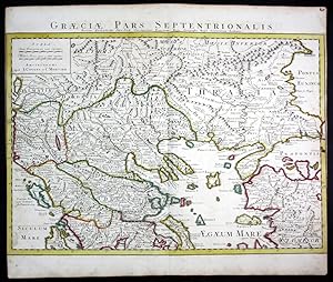
Graeciae pars septentrionalis" - Greece Turkey Griechenland Türkei map Karte Covens Mortier engraving
Edité par Amsterdam, Covens & Mortier um 1730., 1730
Vendeur : Antiquariat Steffen Völkel GmbH, Seubersdorf, Allemagne
Membre d'association : ILAB VDA
Evaluation du vendeur :
Carte
original altkolorierte Kupferstich-Karte von ca. 1730 - Blattformat: ca. 65 x 54 cm - an den seitlichen Rändern knapp beschnitten, sonst gut erhalten. | original hand-colored copper engraved map from circa 1730 - size of sheet: circa 25.6 x 21.3 inches - cut close on right and left margins, otherwise in good condition. Sprache: Deutsch Gewicht in Gramm: 1500.
-
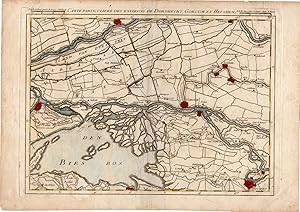
Antique Print-DORDRECHT-GORINCHEM-HEUSDEN-BIESBOSCH-Covens and Mortier-1747
Date d'édition : 1747
Vendeur : Pictura Prints, Art & Books, Overasselt, Pays-Bas
Membre d'association : ILAB NVVA
Evaluation du vendeur :
Etat : Good. Covens and Mortier (illustrateur). 'Carte particuliere des environs de Dordrecht, Gorcum et Heusden.'Engraving on hand laid (verge) paper. Sheet size: 36,7 x 26 cm. (14,4 x 10,2 inch). Image size: 30,5 x 23 cm. (12 x 9,1 inch).From a scarce atlas published in 1747 in Brussels by E.H. Frix and by other publishers in Ghent and in Rijssel: 'Nouveau Theatre de la Guerre aux Pays Bas, ou Cartes tres detaillees du Duche de Brabant et partie de la Hollande.Made by 'Anonymous' after 'Covens and Mortier'. Condition: Good, given age. Light soiling, crease in right lower corner, small tear in upper and left margin been restored. Some chipping of paper edges. General age-related toning and/or occasional minor defects from handling. Please study scan carefully.Keywords: DORDRECHT-GORKUM-GORINCHEM-HEUSDEN-BIESBOSCH-SOUTH NETHERLANDSRBOS-A1-25.
-
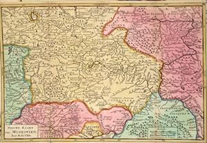
Nieuwe Kaart van Muskovien .
Edité par Artist: L Isle de /Covens & Mortier Guillaume ( - 1726 ) Paris ; issued in: Paris ; ca: 1720; - Guillaume De L isle (1675- 1726) Paris was a French cartographer known for his popular and accurate maps of Europe and the newly explored Americas and Africa De L isle was admitted into the French Académie Royale des Sciences an institution financed by the French state After that date he signed his maps with the title of ?Géographe de l?Académie? Five years later he moved to the Quai de l?Horloge in Paris a true publishing hub where his business prospered De L isle?s ascension through the ranks culminated in 1718 when he received the title of Premier Géographe du Roi His new office consisted in teaching geography to the Dauphin King Louis XIV?s s, 1675
Vendeur : Antique Sommer& Sapunaru KG, München, Allemagne
Membre d'association : ILAB VDA
Evaluation du vendeur :
Technic: Copper print; colorit: original colored; condition: Very good, size (in cm): 17,5 x 26; - map shows the area around Moscow.
-
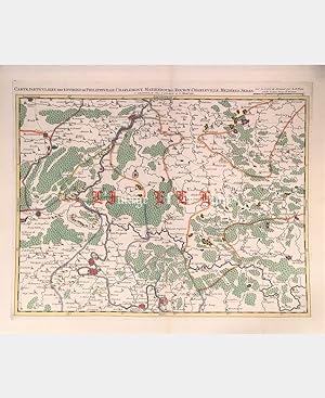
Pas de couverture. Etat : Trčs bon. Carte particuličre des environs de Philippeville, Charlemont, Marienbourg, Rocroy, Charleville, Mezieres, Sedan. Covens (Johannes), Mortier (Cornelis). Gravure sur cuivre. XVIIIe sičcle. Coloris main. Imprimée ŕ Amsterdam chez Covens et Mortier, d'aprčs la carte de Fricx. Dimension du feuillet : 558 x 662 mm. Dimension au coup de planche : 447 x 568 mm. Pli central. Grandes marges. Trčs belle épreuve.Le prix du port est calculé selon la destination et le poids du colis. Cartes.
-
Geographia Patriarchalis Tabula Geographica in Eptiomen Contracta in qua Patriarchatus Antiqui Romanus Interesting map of Europe, North Africa and Mediterranean showing the areas under authority of several patriarchs.
Edité par c. 1700, 1700
Vendeur : Curtis Wright Maps, Berwyn, IL, Etats-Unis
Membre d'association : ESA MWABA
Evaluation du vendeur :
Etat : Fine. Originally designed by Nicholas Sanson (who is duly credited in the colorful title cartouche), this map was published by the famed firm of Covens & Mortier in Amsterdam around the year 1700. It shows the area from the Straits of Gibraltar to the Middle East and the Red Sea to the Baltic, displaying topographical details, cities, and regional information. Various colors on the map are generally representative of the areas under the authority of the Christian patriarchs. Rome (light green), Alexandria (yellow) and Antioch (dark green) were original apostolic sees organized in the first century AD. Constantinople (red) and Jerusalem (orange) were added in the 4th and 5th centuries to form the Pentarchy - the governing body of the early Christian church. Infighting, political strain and religious differences between the patriarchs eventually led to the East-West Schism and the break between Catholic and Eastern Orthodox Christianity. Sheet Width (in) 23.5 Sheet Height (in) 20.6 Condition Description The map is in excellent condition, published on laid paper with old body and cartouche color. Some toning, but otherwise superb condition.
-
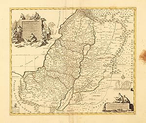
Carte de la Terre Sainte divisée selon les Douze Tribus d Israel cu sent Exacetement Marquez les Porages de Iesus Christ - dressée pour bien entendre les Histores de la Bible. Par le scu de I. Covens R.C. Mortier
Edité par Covens & Mortier, Amsterdam, 1755
Vendeur : Antiquariat Reinhold Berg eK Inh. R.Berg, Regensburg, Allemagne
Membre d'association : ILAB VDA
Evaluation du vendeur :
Carte
Other. Copper engraving, hand colored in outline. In acceptable. At the right side is a brown spot. Not affecting the image. Tears at the bottom. 399 by 466mm (15ľ by 18Ľ inches).
-
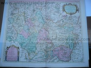
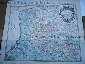
Etat : Good. 'Partie Meridionale du Duché de Bourgogne'. COVENS & MORTIER/DE L'ISLE c1730 map. Antique hand coloured eighteenth century copperplate map. Original colour in outline; J. Covens et C. Mortier / Guillaume de l'Isle (c1730). 51.5 x 65.0cm, 20.25 x 25.5 inches; this is a folding map. Condition: Good. Spot; Minor offsetting -text and/or images from the facing page have left an impression on the print. Strong, dark impression with attractive old colour. There is nothing printed on the reverse side, which is plain. A map of the southern part of the Duchy of Burgundy, covering the present day département of Sâone-et-Loire, and the southern part of Côte-d'Or. The map covers the area from Nuits-Saint-Georges, Dole and Beaune in the north, Lons-le-Saunier, Mâcon and Beaujolais in the south, to Marcigny, Bourbon-Lancy and Château-Chinon in the west. Châlon-sur-Saone is marked.
-

CARTE PARTICULIERE DE LA HONGRIE, DE LA TRANSILVANIE, DE LA CROATIE ET DE LA SCLAVONIE . Map of Hungary and Slovakia and adjacent parts of Croatia, Serbia and Romania (Transylvania). After designs by Marsilli published by Jean Covens & Corneille Mortier from the plate by
Edité par Guillaume de l Isle ca. 1730, 1730
Carte
49x57cm. Original outline colour. Excellent condition.
-
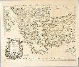
Accurata Totius Archipelagi et Graeciae universae Tabula / Carte de la Grece dressée sur un grand nombre de memoires .
Edité par Amsterdam
Etat : Trčs bon. Carte uniformement brunie. Petite coupure et décoloration dans le coin inférieur droit.Carte détaillée de la Grčce incluant l'Albanie, la Macédoine, une partie de la Turquie et Chypre // ENGLISH // Map uniformly browned. Small cut and discoloration in the lower right corner.Detailed map of Greece including Albania, Macedonia, part of Turkey and Cyprus.
-
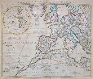
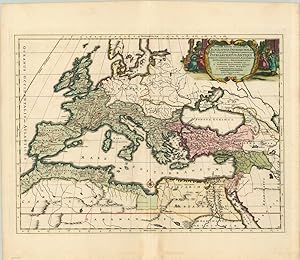
THEATRUM HISTORICUM - PARS OCCIDENTALIS
Date d'édition : 1733
Vendeur : LUX IN ART di Ermanno Bertelli, Verona, VERON, Italie
Evaluation du vendeur :
Carte
Etat : ottimo. Incisione in rame. Bellissima carta del Teatro Storico ritraente la parte occidentale, dell'Impero Romano disegnata dai cartografi Covens - Moriter. Ottimo esemplare con bella coloritura, perfettamente conservato. Formato: 500x610mm.
-
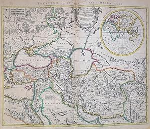
THEATRUM HISTORICUM - PARS ORIENTALIS
Date d'édition : 1730
Vendeur : LUX IN ART di Ermanno Bertelli, Verona, VERON, Italie
Evaluation du vendeur :
Carte
Etat : ottimo. Incisione in rame. Bellissima carta del Teatro Storico ritraente la parte orientale, dell'Impero Romano disegnata dai cartografi Covens - Moriter. Ottimo esemplare con bella coloritura, perfettamente conservato. Formato: 500x610mm.
-
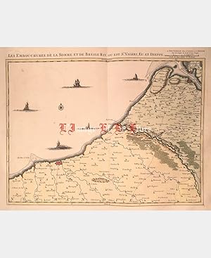
Pas de couverture. Etat : Bon. Les embouchures de la Somme et de Bresle Riv. ou est St. Valeri, Eu et Dieppe. Gravure sur cuivre. XVIIIe sičcle. Amsterdam, J. Covens & C. Mortier. Coloris d'époque. Dimension du feuillet : 562 x 680 mm. Dimension au coup de planche : 447 x 560 mm. Carte des embouchures de la Somme et de la Bresle et du littoral allant d'Epineville - Quiberville jusqu'au Crotoy. Pliure centrale. Anciennes annotations ŕ la plume grattées au verso dans la marge et la cuvette, trčs légčres rousseurs. Le prix du port est calculé selon la destination et le poids du colis. Cartes.
-
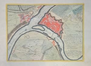
Coblentz
Edité par Artist: L Isle de /Covens & Mortier Guillaume ( - 1726 ) Paris ; issued in: Paris ; dated: 1705; - Guillaume De L isle (1675- 1726) Paris was a French cartographer known for his popular and accurate maps of Europe and the newly explored Americas and Africa De L isle was admitted into the French Académie Royale des Sciences an institution financed by the French state After that date he signed his maps with the title of ?Géographe de l?Académie? Five years later he moved to the Quai de l?Horloge in Paris a true publishing hub where his business prospered De L isle?s ascension through the ranks culminated in 1718 when he received the title of Premier Géographe du Roi His new office consisted in teaching geography to the Dauphin King Louis XIV?, 1675
Vendeur : Antique Sommer& Sapunaru KG, München, Allemagne
Membre d'association : ILAB VDA
Evaluation du vendeur :
Technic: Copper print; colorit: original colored; condition: Very good, size (in cm): 19,5 x 26; - Map shows the city map of Coblenz with the rivers Rhein and Mosel and the castle Ermanstein.
-
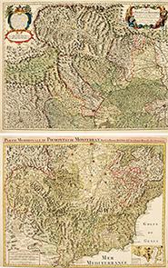
PARTIE MERIDIONALE DU PIEMONT ET DU MONFERRAT, Par Guillaume Del'Isle de l'Academie Royale des Sciences.
Edité par Amsterdam. c1740, 1740
Vendeur : Peter Harrington. ABA/ ILAB., London, Royaume-Uni
Membre d'association : ABA ILAB PBFA
Evaluation du vendeur :
One of a handsome pair of maps of France. This shows the area from Turin down to the riviera and Gulf of Genoa. Inset map of the environs of Nice and Ville Franche. Copper engraving. Original colour. Fine condition, good margins, the lower margin runs close to the plate, but it was published that way. Size: 63.2 x 47.5 cm.
-
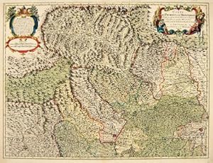
CARTE DU PIEMONT et du MONFERRAT.
Edité par Paris. c1740, 1740
Vendeur : Peter Harrington. ABA/ ILAB., London, Royaume-Uni
Membre d'association : ABA ILAB PBFA
Evaluation du vendeur :
A handsome of map southern of France, covering the French and Italian Alps from the St Bernard pass to just south of Turin. From Barcelona in the west to Alba in the east Size: 632 x 475 mm. Copper engraving. Original colour. Very good condition.
-
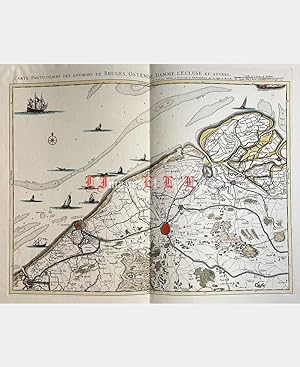
Pas de couverture. Etat : Trčs bon. Carte particuliere des environs de Bruges, Ostende, Damme, L'Ecluse et autres. Johannes Covens et Cornelis Mortier. Gravure sur cuivre. 1745. Coloris d'époque. Pliure centrale verticale. Dimension du feuillet : 568 x 686 mm. Dimension au coup de planche : 435 x 555 mm. Se vend chez Covens et Mortier ŕ Amsterdam sur la copie de Bruxelles chez Eugčne-Henri Fricx. Trčs belle épreuve.Le prix du port est calculé selon la destination et le poids du colis. Art, Affiches et Gravures.
-
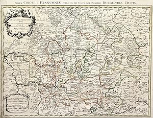
Nova Circuli Franconiae tabula.
Edité par Amsterdam,, 1759
Vendeur : libreria antiquaria perini Sas di Perini, Verona, VR, Italie
Membre d'association : ALAI ILAB
Evaluation du vendeur :
Art / Affiche / Gravure
Incisione in rame, colorata d'epoca ai confini, mm. 485x620. Ben conservata, con leggere mancanze e tracce di umidit? al margine sinistro rinforzato. Nr.cat: 100_6898.
-
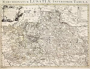
Marchionatus Lusatiae inferioris.
Edité par Amsterdam,, 1759
Vendeur : libreria antiquaria perini Sas di Perini, Verona, VR, Italie
Membre d'association : ALAI ILAB
Evaluation du vendeur :
Art / Affiche / Gravure
Incisione in rame, colorata d'epoca ai confini, mm. 470x615. Ben conservata, qualche piccolo restauro e tracce di umidit? marginali. Nr.cat: 100_6895.
-
![Image du vendeur pour Asia accurate in Imperia, Regna, Status &Populos divisa ad usum Ludovici XV. Galliarum Regis. [Altkolorierter Kupferstich um 1750 / colored copper engraving]. Carte d'Asie dressee sur les Memoires envoyez par le Czar a l'Academie Royale des Science.Par G. De l'Isle. Nouvellement corrigee apres les dernieres Decouvertes faite par l'Academie de Petersbourg. A Amsterdam par Covens et Mortier. mis en vente par Antiquariat Lenzen](https://pictures.abebooks.com/inventory/md/md10942355029.jpg)
Asia accurate in Imperia, Regna, Status &Populos divisa ad usum Ludovici XV. Galliarum Regis. [Altkolorierter Kupferstich um 1750 / colored copper engraving]. Carte d'Asie dressee sur les Memoires envoyez par le Czar a l'Academie Royale des Science.Par G. De l'Isle. Nouvellement corrigee apres les dernieres Decouvertes faite par l'Academie de Petersbourg. A Amsterdam par Covens et Mortier.
Vendeur : Antiquariat Lenzen, Düsseldorf, Allemagne
Membre d'association : GIAQ ILAB VDA
Evaluation du vendeur :
Art / Affiche / Gravure Edition originale
Altkolorierte Karte nach G. de l'Isle herausgegeben von Covens & Mortier um 1750. Karte mit Titel- und Meilenkartusche. Maße Blatt: ca. 51,0 x 61,0 cm. Maße Platte: 47,0 x 57,0 cm. Karte hinter Passepartout montiert (63,5 x 72,5 cm). Karte mit wenigen kleinen Fleckchen, Kolorierung verblasst. Gutes bis sehr gutes Exemplar. Colored cooper engraving from about 1750. Measure sheet: 51,0 x 61,0 cm. Measure plate: 47,0 x 57,0 cm. Map mounted behind passepartout (63,5 x 72,5 cm). Map with few little spotts, color paled, otherwise nearly fine condition.
-
Artois, map, anno 1745, Covens & Mortier, fine print
Edité par Covens & Mortier
Vendeur : Hammelburger Antiquariat, Hammelburg, Allemagne
Evaluation du vendeur :
Carte
Hardcover. Etat : Gut. Artois, map, anno 1745, Covens & Mortier, fine print, printed on thick paper, little brownish, small tears on margins Publisher: COVENS, J. / MORTIER, C. Title: Carte D'Artois ET Des Environs. Published: Amsterdam c. 1745 Size: 50.0 x 60.0 cm. Colouring: In original colours. Condition: Printed on thick paper. Very good condition. Topographically detailed regional map of the Artois region in northern France. The map extends from Abeville in the West to Douai, Cambrai and Lille in the East. Shows the towns of Arras, Calais, Boulogne-sur-Mer, Saint-Omer, Lens, Béthune, etc.
-
Le Gouvernement General du Lyonnois The Covens & Mortier edition of Sanson's map of the noted food and wine region of Lyon, in France.
Edité par c. 1730, 1730
Vendeur : Curtis Wright Maps, Berwyn, IL, Etats-Unis
Membre d'association : ESA MWABA
Evaluation du vendeur :
Etat : Fine. This fascinating and detailed copperplate engraved map shows the region immediately surrounding the city of Lyon, France. Topographical features such as forests and mountains are depicted pictorially, while the various place names within the image are identified according to a complex system of symbols further detailed in the accompanying legend (lower left). Other local landmarks of interest are noted; including a large stretch of aqueduct southwest of the city 'made by the Romans' and the small river Furand, which despite its diminutive stature is swift enough to support 117 water mills in the production of paper, textiles, lumber and arms. The decorative cartouche contains personifications of the rivers Rhone and Saone, the Roman god Mercury, the coat of arms of Lyon and other allegorical figures. Published in Amsterdam by Covens & Mortier around 1730. Sheet Width (in) 25.1 Sheet Height (in) 21.5 Condition Description One small spot in the lower right margin, well away from the image. Fine condition, with attractive hand color. Issued on watermarked paper.
-
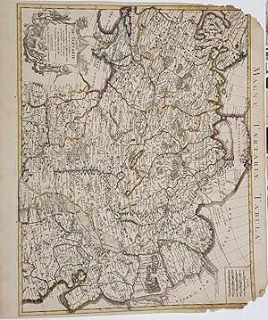
CARTE DE Tartarie (Magnae Tartariae Tabula)
Date d'édition : 1750
Carte
No Binding. Etat : As New. map of Tartary, consisting of the Eastern part of Russia, Central Asia, China and Korea, first published by Nicholas De L'Isle in 1706. The map extends from the Peninsula of Korea in the east to the Caspian and Black Seas. The Great Wall of China is shown, as is the Silk Route, many roads and remote settlements, mountain ranges, rivers, etc. The wide swath of the Gobi Desert appears quite prominently, as does the Great Kingdom of Tibet, Cossack regions, the Country of the Mongols and many other features. De L'Isle was France's leading map maker in the early 18th Century and he and his heirs dominated the French map trade during most of the 18th Century.
-
Toul-Civitas Leucorum sive Pagus Tullensis aujourd'hui le Diocčse de Toul.
Date d'édition : 1742
Amsterdam, De l'Isle, 1742; 490/585mm, 1ff, bel état. Grande carte coloriée d'époque du Diocčse de Toul, oů l'on peut découvrir les villes de Nancy et Toul , mais également Metz, Verdun, Saint-Dizier, Neufchâteau, Mirecourt, Remiremont, etc. Illustré de deux cartouches décorés. Extraite de l'ouvrage monumental de De l'Isle "Atlas nouveau, contenant toutes les parties du Monde, oů sont exactement remarqués les Empires, Monarchies, Royaumes, Etats, Républiques, etc.
-
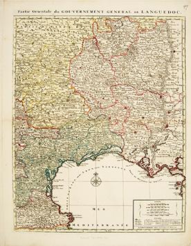
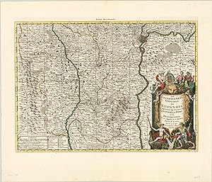
Partie Orientale du Gouvernement General de Languedoc
Edité par Amsterdam. [c.1750], 1750
Vendeur : Peter Harrington. ABA/ ILAB., London, Royaume-Uni
Membre d'association : ABA ILAB PBFA
Evaluation du vendeur :
Attractive and detailed map of eastern Languedoc, from Corbieres to the Marseilles and north as far as St Paulhan. title on top border of the map, five scales at lower right. Coloured by region. Copper engraving. Later colouring. Fine condition, good margins, closed tear at lower edge, 1cm strip of paper pasted along edge of right hand margin, not affecting map Size: 46 x 57.5 cm.
-
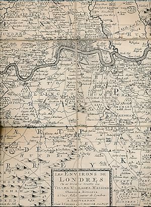
Les Environs de Londres ou se Trouve Toutte les Villes, Villages, Maisons Chemins, Rivieres, ŕ Vingt Milles autour de Londres. 1725
Edité par I Covens & C Mortier [1725], Amsterdam, 1725
Vendeur : Barter Books Ltd, Alnwick, NORTH, Royaume-Uni
Membre d'association : IOBA
Evaluation du vendeur :
No cover. Etat : G : in good condition. Reprint. 490mm x 560mm (19" x 22"). 16 linen panels. Text in French. Based on Morden & Lea's 1688 map.

![Image du vendeur pour Partie Meridionale du Duché de Bourgogne, Par Guillaume De l'Isle, Premier Geographe du Roy de l'Academie Royale des Sciences. Carte du Duché de Bourgogne et des Comtez en dependans [Southern part of the Duchy of Burgundy by Guillaume de L'Isle, first Geographer to the King, of Royal Academy of Sciences. Map of the Duchy of Burgundy and its counties and dependancies] mis en vente par Antiqua Print Gallery](https://pictures.abebooks.com/inventory/md/md31102173790.jpg)