Montant total (1 article articles) :
Destination de la commande :

diercke carl (90 résultats)
Passer aux résultats principaux de la recherche
Type d'article
- Tous les types de produits
- Livres (90)
- Magazines & Périodiques
- Bandes dessinées
- Partitions de musique
- Art, Affiches et Gravures
- Photographies
- Cartes
- Manuscrits & Papiers anciens
Etat
Reliure
Particularités
Livraison gratuite
- Frais de port gratuits USA
Pays
Evaluation du vendeur
-
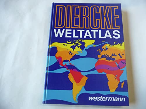
Diercke. Die Welt in Karten. (Publikumsatlas)
Edité par Westermann, 2003
ISBN 10 : 3075092738ISBN 13 : 9783075092736
Livre
Hardcover. Etat : Good. Connecting readers with great books since 1972! Used textbooks may not include companion materials such as access codes, etc. May have some wear or writing/highlighting. We ship orders daily and Customer Service is our top priority!.
Plus de choix d'achat de la part d'autres vendeurs sur AbeBooks
Offres d'occasion ŕ partir de EUR 3,80
Trouvez également Couverture rigide
-
Diercke Weltatlas
Edité par Westermann, 1991
ISBN 10 : 3141006008ISBN 13 : 9783141006001
Vendeur : Better World Books, Mishawaka, IN, Etats-Unis
Evaluation du vendeur :

Livre
Etat : Very Good. 2. aktualsierte Aufl. Used book that is in excellent condition. May show signs of wear or have minor defects.
Plus de choix d'achat de la part d'autres vendeurs sur AbeBooks
Offres d'occasion ŕ partir de EUR 7,60
Trouvez également Couverture rigide Couverture souple
-
Diercke Weltatlas (German Edition)
Edité par Westermann, 1978
ISBN 10 : 3141005001ISBN 13 : 9783141005004
Vendeur : Wonder Book, Frederick, MD, Etats-Unis
Membre d'association : ABAA ILAB
Evaluation du vendeur :
Livre
Etat : Good. Good condition. A copy that has been read but remains intact. May contain markings such as bookplates, stamps, limited notes and highlighting, or a few light stains.
Plus de choix d'achat de la part d'autres vendeurs sur AbeBooks
Offres neuf ŕ partir de EUR 63,26
Offres d'occasion ŕ partir de EUR 8,69
Trouvez également Couverture rigide Couverture souple
-
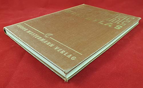
Diercke Weltatlas. (braun) (Westermann)
Edité par Georg Westermann Verlag, 1966
ISBN 10 : 314100000XISBN 13 : 9783141000009
Livre
Ausreichend/Acceptable: Exemplar mit vollständigem Text und sämtlichen Abbildungen oder Karten. Schmutztitel oder Vorsatz können fehlen. Einband bzw. Schutzumschlag weisen unter Umständen starke Gebrauchsspuren auf. / Describes a book or dust jacket that has the complete text pages (including those with maps or plates) but may lack endpapers, half-title, etc. (which must be noted). Binding, dust jacket (if any), etc may also be worn.
Plus de choix d'achat de la part d'autres vendeurs sur AbeBooks
Offres d'occasion ŕ partir de EUR 8,72
Trouvez également Couverture rigide Couverture souple
-

Weltatlas. Diercke. Ausgeführt in d. kartogr. Anstalt von Georg Westermann in Braunschweig
Edité par Braunschweig ; Berlin ; Hamburg ; München ; Kiel ; Darmstadt : Westermann [1955]., 1955
Vendeur : Antiquariat-Fischer - Preise inkl. MWST, Freiburg, Allemagne
Evaluation du vendeur :
Livre
Hlw. Etat : Gut. 88. Aufl. IV, 142 S. ; 4 Ecken und Einband stark bestoßen bzw. beschabt, innen: gut erhalten 9-70 Sprache: Deutsch Gewicht in Gramm: 1200.
-

Softcover. 9. Auflage. Ehem. Bibliotheksexemplar mit Signatur und Stempel. GUTER Zustand, ein paar Gebrauchsspuren. Ex-library with stamp and library-signature. GOOD condition, some traces of use. Ha 1119 Sprache: Deutsch Gewicht in Gramm: 100.
-
DIERCKE SCHULATLAS FÜR HÖHERE LEHRANSTALTEN : GROSZE AUSGABE
Edité par Georg Westerman, Braunschweig, 1917
Vendeur : Second Story Books, ABAA, Rockville, MD, Etats-Unis
Membre d'association : ABAA ILAB
Evaluation du vendeur :

Hardcover. Fifty-second edition. Quarto, vi, 156 pages. In Fair condition. Spine is black without print. Boards quarter bound with black cloth to spine and brown cloth to boards. Tattering to spine caps, corners worn and exposed, rubbing, shelf wear. Text block has shaken binding, name in ink and owner stamp on title page, intermittent spine breaks, pages 49-56 loose from binding. Illustrated: color maps, some folded. [Oversized book(s). Additional postage necessary for expedited/international orders. Economy International shipping unavailable due to size/weight restrictions. For international/expedited customers, please inquire for rates]. NOTE: Shelved in Locked Annex Area, Quarto and Folio Case. 1379263. FP New Rockville Stock.
-
DIERCKE Handbuch Karteninterpretationen. Lernziele und didaktische Hinweise. Literatur.
Edité par Westermann, 1976
ISBN 10 : 3141095000ISBN 13 : 9783141095005
Livre
Etat : Gebraucht. Gebraucht - Gut !!! 1. Auflage von 1976 !!! Sofortversand,uebliche Markierungsstempel/Zeichen, altersgemaesser GUTER Zustand.
-

Etat : Gebraucht. Gebraucht - Gut !!! gebundene Papp Ausgabe v 1954 !!! Sofortversand,uebliche Markierungsstempel/Zeichen, altersgemaesser GUTER Zustand.
-
Diercke Weltatlas Österreich
Edité par Westermann, 2013
ISBN 10 : 3703421223ISBN 13 : 9783703421228
Livre
Etat : Fine. Deutsch.
Plus de choix d'achat de la part d'autres vendeurs sur AbeBooks
Offres d'occasion ŕ partir de EUR 3
Trouvez également Couverture rigide
-
Weltatlas : Begr. von C. Diercke. Fortgef. von R. Dehmel.
Edité par Braunschweig ; Berlin ; Hamburg ; München ; Kiel ; Darmstadt : Westermann, 1966
Vendeur : Antiquariat Buchhandel Daniel Viertel, Diez, Allemagne
Evaluation du vendeur :
Livre
4°, Lw., Goldprägungen, Etat : Sehr gut. 128. Aufl. (40. Aufl. d. Neubearb.). 168, 57 S. ; Kt., gebraucht, sehr gut, 26971 Sprache: Deutsch Gewicht in Gramm: 400.
-
![Image du vendeur pour Westermanns Hausatlas : [Mit] 150 Farbphotos aus aller Welt. Ktn von C. Diercke u. R. Dehmel. Ausw. u. Text von W. Tietze mis en vente par AHA-BUCH](https://pictures.abebooks.com/inventory/md/md15777121779.jpg)
Westermanns Hausatlas : [Mit] 150 Farbphotos aus aller Welt. Ktn von C. Diercke u. R. Dehmel. Ausw. u. Text von W. Tietze
Edité par Braunschweig : Westermann,, 1961
Gebundene Ausgabe. Etat : Gebraucht. Gebraucht - Gut Aq - altersgemäßer Zustand, Namenszug / Markierungen möglich, Sofortversand.
-
Westermanns Hausatlas
Edité par Braunschweig : Westermann,
Vendeur : JLG_livres anciens et modernes, Saint Maur des Fossés, France
Membre d'association : ILAB
Evaluation du vendeur :
Livre
Etat : Trčs bon. Nos envois se font avec suivi, pour tout problčme n'hésitez pas ŕ nous contacter pour trouver une solution.
-
Diercke Länderlexikon (6433 820)
Edité par Westermann Sachbuch, 1989
ISBN 10 : 3145088513ISBN 13 : 9783145088515
Vendeur : Das Buchregal GmbH, Ginsheim-Gustavsburg, HE, Allemagne
Evaluation du vendeur :
Livre
Gebundene Ausgabe. Etat : Sehr gut. 800 Seiten OSU oben etwas berieben, oben rissspurig. Buch sehr gut. Sauberes Buch aus Nichtraucherhaushalt___Schönes Leseexemplar___Versand erfolgt im ein bis zwei Tagesrhytmus ____Zustand siehe Bilder; weitere Bilder/Infos gern auf Anfrage____Die von uns Angebotenen Bücher kommen aus Nichtraucherhashalten und sind, wenn nicht anders beschrieben, mit normalen Gebrauchsspuren____ Versicherter Versand mit Sendungsnummer Ihr Buchregal Sprache: Deutsch Gewicht in Gramm: 3180.
Plus de choix d'achat de la part d'autres vendeurs sur AbeBooks
Offres d'occasion ŕ partir de EUR 9,82
Trouvez également Couverture rigide Edition originale
-
Schulatlas für Höhere Lehranstalten. Große Ausgabe. 78. Aufl.
Edité par Braunschweig, Berlin, Leipzig, Hamburg, Westemann (um 1939)., 1939
Vendeur : Antiquariat Löcker, Wien, Autriche
Membre d'association : GIAQ ILAB VDA VDAO
Evaluation du vendeur :
36 x 24 cm. VI, 159 Karten (die letzte Karte ist am hinteren Innendeckel aufkasch., am vord. Innendeckel ist - quasi als Ergänzung - eine Karte der Gaue der NSDAP montiert, Innentit. gestempelt "1. Heeresfachschule Wien", flieg. Vors. fingerfleckig, OHLn., schwache Lichtspuren am Einband, 2 kl. weiße Farbflecken am Vorderdeckel.
-
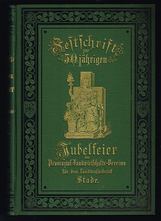
Festschrift zur 50jährigen Jubelfeier des Provinzial-Landwirtschafts-Vereines zu Bremervörde (Regierungsbezirk Stade): Zweiter Band. -
Edité par Stade, A. Pockwitz,, 1886
Vendeur : Libresso Antiquariat, Jens Hagedorn, Harsefeld, Allemagne
Evaluation du vendeur :
Livre
X, 314 Seiten, Mit Statistiken; mit Titelbild (Ackerbauschule Bremervörde); Anhang; 4 Ausklapp-Tafeln mit Statistiken, 12 Karten auf 6 Tafeln; --- Einband leicht berieben, Seiten leicht nachgedunkelt, vereinzelt Stockflecken Sprache: Deutsch Gewicht in Gramm: 850 Lex.-8°, Gebundene Ausgabe / Halbleinen.
-
Atlas für Mittelschulen. (Karten vollständig.)
Edité par Braunschweig. Westermann (ca. 1935.), 1935
Vendeur : HENNWACK - Berlins größtes Antiquariat, Berlin, Allemagne
Evaluation du vendeur :
4to. 53 S. OHLn. Buchblock gering gelockert, wenige Blätter wenig wasserrandig, sonst gutes Exemplar. Sprache: deutsch.
-
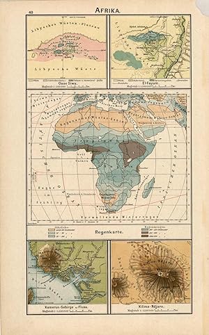
Afrika (Africa)
Date d'édition : 1902
Vendeur : Art Source International Inc., Boulder, CO, Etats-Unis
Evaluation du vendeur :

This map was produced for the 1902 Diercke, Schul-Atlas fur Hohere Lehranstalten, (Diercke Education Atlas for Higher Educational Institutions) This atlas was prepared and issued by C. Diercke and E.Gaebler for the Westermann publishing group in Braunschweig. With the help of fellow cartographer, Eduard Gaebler, Carl Dierckes maps became a staple in the geography classrooms in Germany. From 1893 until his death, Diercke was editor of all the maps for Westermann Verlag. All text is in German with full color that has remained quite bold. A wonderful example of the fine German engraving work of the time. These beautiful, topographic maps show the physical attributes and contours of the land as well as identifies cities, countries, rivers, mountains, boundaries, and more. This is a single-sided map with five small sections showing of attributes or regions of Africa including: Oase Siwa (Siwa Oasis), El Fayum, Regenkarte (Rain Map), Kamerun-Gebirge (Cameroon Mountains), and Kilima-Ndjaro (Kilimandjaro). This map measures 12 inches by 6.75 inches.
-
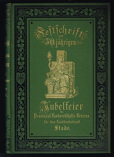
Festschrift zur 50jährigen Jubelfeier des Provinzial-Landwirtschafts-Vereines zu Bremervörde (Regierungsbezirk Stade): Zweiter Band. -
Edité par Stade, A. Pockwitz,, 1886
Vendeur : Libresso Antiquariat, Jens Hagedorn, Harsefeld, Allemagne
Evaluation du vendeur :
Livre
X, 314 Seiten, Mit Statistiken; mit Titelbild (Ackerbauschule Bremervörde); Anhang; 4 Ausklapp-Tafeln mit Statistiken, 12 Karten auf 6 Tafeln; --- geringe Gebrauchsspuren, Seiten leicht nachgedunkelt, vereinzelt Stockflecken Sprache: Deutsch Gewicht in Gramm: 850 Lex.-8°, Gebundene Ausgabe / Halbleinen.
-
Hardcover. Etat : Gut. 31 x 25 cm Original-Halbleinen-Band ohne Schutzumschlag, Einband mit etwas stärkeren Gebrauchsspuren, Papier altersbedingt etwas fleckig und gebräunt, sonst GUTES EXEMPLAR--- , XIV,48 Seiten. nein.
-
Festschrift zur 50jährigen Jubelfeier des Provinzial-Landwirtschafts-Vereines zu Bremervörde (Regierungsbezirk Stade). -
Edité par Stade, A. Pockwitz,, 1885
Vendeur : Libresso Antiquariat, Jens Hagedorn, Harsefeld, Allemagne
Evaluation du vendeur :
Livre
XIX / 584 Seiten, Anhang: 23 Statistische Tabellen auf 12 Ausklapp-Tafeln; 1 Falttafel (Gang der Temperatur für Otterndorf und Lüneburg), 1 Tafel (Niederschlagshöhen für Otterndorf, Lüneburg und Bremen), 4 Bildtafeln (Altländer Bauernhaus, Bauernhaus von der Geest, Frauentrachten, Brauttrachten), 1 Faltplan (Plan zu zwei genossenschaftlichen Bewässerungsanlagen an der oberen Oste, Unterhalt Siten, Kreis Zeven), 1 farbige Falttafel (Karte des Regierunbgsbezirks Stade); Inhalt: Geschichtlicher Teil / Geographisch-naturwissenschaftlicher Teil / Landwirtschaftlicher Teil (Grundvermögen und agrarische Zustände; Der landwirtschaftliche Betrieb; Der forstwirtschaftliche Betrieb);--- Einband berieben, Titel mit Stempel und Besitzervermerk, Seiten etwas nachgebunkelt, vereinzelt braunfleckig, 3 Falttafeln mit Einrissen Sprache: Deutsch Gewicht in Gramm: 1400 Lex.-8°, Gebundene Ausgabe / Halbleinen.
-
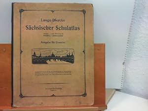
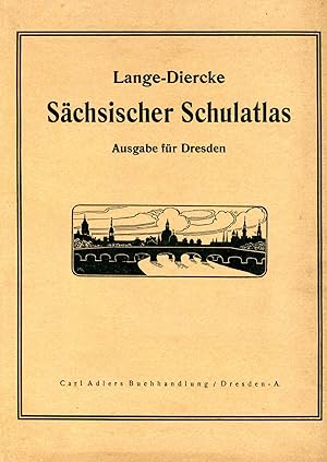
Lange - Diercke Sächsischer Schulatlas - Ausgabe für Dresden
Edité par Dresden, Carl Adler's Buchhandlung, 1938
Livre
Hardcover/Pappeinband. Etat : Gut. 42 Seiten 31 cm x 25 cm, mit altersbedingten Gebrauchsspuren, Einband fleckig und bestossen, Buchblock gelöst, Seiten ebenfalls fleckig und nachgedunkelt W16 Sprache: Deutsch Gewicht in Gramm: 460.
-
Etat : Sehr gut. Zustand: Sehr gut - Gepflegter, sauberer Zustand. 4. Auflage. | ISBN/EAN: B007WYLFVK[Sonstiges].
-
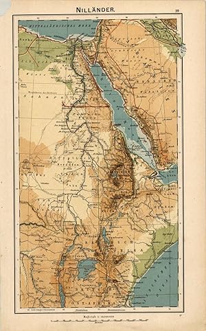
Nilländer (Nile River)
Date d'édition : 1902
Vendeur : Art Source International Inc., Boulder, CO, Etats-Unis
Evaluation du vendeur :
This map was produced for the 1902 Diercke, Schul-Atlas fur Hohere Lehranstalten, (Diercke Education Atlas for Higher Educational Institutions) This atlas was prepared and issued by C. Diercke and E.Gaebler for the Westermann publishing group in Braunschweig. With the help of fellow cartographer, Eduard Gaebler, Carl Dierckes maps became a staple in the geography classrooms in Germany. From 1893 until his death, Diercke was editor of all the maps for Westermann Verlag. All text is in German with full color that has remained quite bold. A wonderful example of the fine German engraving work of the time. These beautiful, topographic maps show the physical attributes and contours of the land as well as identifies cities, countries, rivers, mountains, boundaries, and more. This single sided map shows the Nile River with a portion of Arabia. This map measures 12 inches by 6.75 inches.
-
Festschrift zur 50jährigen Jubelfeier des Provinzial-Landwirtschafts-Vereines zu Bremervörde (Regierungsbezirk Stade). -
Edité par Stade, A. Pockwitz,, 1885
Vendeur : Libresso Antiquariat, Jens Hagedorn, Harsefeld, Allemagne
Evaluation du vendeur :
Livre
XIX / 584 Seiten, Anhang: 23 Statistische Tabellen auf 12 Ausklapp-Tafeln; 1 Falttafel (Gang der Temperatur für Otterndorf und Lüneburg), 1 Tafel (Niederschlagshöhen für Otterndorf, Lüneburg und Bremen), 4 Bildtafeln (Altländer Bauernhaus, Bauernhaus von der Geest, Frauentrachten, Brauttrachten), 1 Faltplan (Plan zu zwei genossenschaftlichen Bewässerungsanlagen an der oberen Oste, Unterhalt Siten, Kreis Zeven), 1 farbige Falttafel (Karte des Regierunbgsbezirks Stade); Inhalt: Geschichtlicher Teil / Geographisch-naturwissenschaftlicher Teil / Landwirtschaftlicher Teil (Grundvermögen und agrarische Zustände; Der landwirtschaftliche Betrieb; Der forstwirtschaftliche Betrieb); --- geringe Gebrauchsspuren, Schnitt etwas stockfleckig Sprache: Deutsch Gewicht in Gramm: 1400 Lex.-8°, Gebundene Ausgabe / Halbleinen.
-
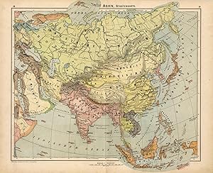
Asien, Staatenkarte (Asia, States)
Date d'édition : 1902
Vendeur : Art Source International Inc., Boulder, CO, Etats-Unis
Evaluation du vendeur :
This map was produced for the 1902 Diercke, Schul-Atlas fur Hohere Lehranstalten, (Diercke Education Atlas for Higher Educational Institutions) This atlas was prepared and issued by C. Diercke and E.Gaebler for the Westermann publishing group in Braunschweig. With the help of fellow cartographer, Eduard Gaebler, Carl Dierckes maps became a staple in the geography classrooms in Germany. From 1893 until his death, Diercke was editor of all the maps for Westermann Verlag. All text is in German with full color that has remained quite bold. A wonderful example of the fine German engraving work of the time. These beautiful, topographic maps show the physical attributes and contours of the land as well as identifies cities, countries, rivers, mountains, boundaries, and more. They are double sided maps (shown side by side in image) which have corresponding information to the country on the opposite side. This map shows Asia, divided into it's states or countries on one side and has ten smaller maps on the other side of several areas within Asia including: Das heutige Jerusalem (Today's Jerusalem), Jerusalem u. Umgegend (Jerusalem and environs), Religionskarte (Religion), Gengend zwischen Nazareth u. Tiberias, Sinai (Sinai Mountains), Eriwan (Yerevan), Pamir (Pamir Mountains), Verbreitung der wichtigsten Pflanzen (dissemination of important plant), Gaurisankar, and Karakorum. This map measures 12 inches by 15 inches.
-
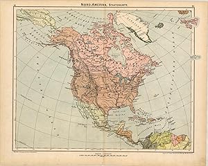
Nord Amerika, Staatenkarte (North America)
Date d'édition : 1902
Vendeur : Art Source International Inc., Boulder, CO, Etats-Unis
Evaluation du vendeur :
This map was produced for the 1902 Diercke, Schul-Atlas fur Hohere Lehranstalten, (Diercke Education Atlas for Higher Educational Institutions) This atlas was prepared and issued by C. Diercke and E.Gaebler for the Westermann publishing group in Braunschweig. With the help of fellow cartographer, Eduard Gaebler, Carl Dierckes maps became a staple in the geography classrooms in Germany. From 1893 until his death, Diercke was editor of all the maps for Westermann Verlag. All text is in German with full color that has remained quite bold. A wonderful example of the fine German engraving work of the time. These beautiful, topographic maps show the physical attributes and contours of the land as well as identifies cities, countries, rivers, mountains, boundaries, and more. They are double sided maps (shown side by side in image) which have corresponding information to the country on the opposite side. This map shows North America, including Greeland, divided into its states on one side and has eight smaller maps on the other regarding: Gr'nlands Westk'ste (Greenland's west coast), Mississippi -M'ndungen (Mississippi estuaries), Bodenbenutzung (soil use), Industriekarte (Industry Map), Kap Hatteras (Cape Hatteras), Canon des Colorado, V'lkerkarte (International Map), and Bev'lkerungsdichte und wichtige Verkehrswege (Population density and major transportation routes). This map measures 12 inches by 15 inches.
-
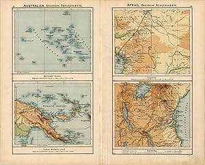
Grosser Ozean (Large Ocean - Pacific Ocean)
Date d'édition : 1902
Vendeur : Art Source International Inc., Boulder, CO, Etats-Unis
Evaluation du vendeur :
This map was produced for the 1902 Diercke, Schul-Atlas fur Hohere Lehranstalten, (Diercke Education Atlas for Higher Educational Institutions) This atlas was prepared and issued by C. Diercke and E.Gaebler for the Westermann publishing group in Braunschweig. With the help of fellow cartographer, Eduard Gaebler, Carl Dierckes maps became a staple in the geography classrooms in Germany. From 1893 until his death, Diercke was editor of all the maps for Westermann Verlag. All text is in German with full color that has remained quite bold. A wonderful example of the fine German engraving work of the time. These beautiful, topographic maps show the physical attributes and contours of the land as well as identifies cities, countries, rivers, mountains, boundaries, and more. They are double sided maps (shown side by side in image) which have corresponding information to the country on the opposite side. This map shows the Pacific Ocean with Australia and North America, with portions of Asia and Africa on one side and has four maps on the other of areas in Australia and Africa showing: Australien, Deutsche Schutzgebiete (Australia, German Conservation Areas) - Marshall Inslen (Marshall Islands) and Kaiser Wilhelm-Land. Afrika, Deutsche Schutzgebiete (Africa, German Conservation Areas) - Kamerun (Cameroons), Ost-Afrika (East Africa). This map measures 12 inches by 15 inches.
-
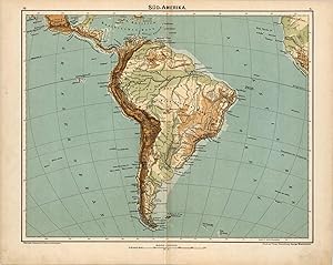
Sà ¿½d-Amerika (South America)
Date d'édition : 1902
Vendeur : Art Source International Inc., Boulder, CO, Etats-Unis
Evaluation du vendeur :
This map was produced for the 1902 Diercke, Schul-Atlas fur Hohere Lehranstalten, (Diercke Education Atlas for Higher Educational Institutions) This atlas was prepared and issued by C. Diercke and E.Gaebler for the Westermann publishing group in Braunschweig. With the help of fellow cartographer, Eduard Gaebler, Carl Dierckes maps became a staple in the geography classrooms in Germany. From 1893 until his death, Diercke was editor of all the maps for Westermann Verlag. All text is in German with full color that has remained quite bold. A wonderful example of the fine German engraving work of the time. These beautiful, topographic maps show the physical attributes and contours of the land as well as identifies cities, countries, rivers, mountains, boundaries, and more. They are double sided maps (shown side by side in image) which have corresponding information to the country on the opposite side. This map shows the continent of South America on one side and has ten maps on the other side regarding: Maranon-M'ndung (Maranon-mouth), Magalhaens-Strasse (Magalhaens-road), Vegetations-u. Regenkarte (Vegetation and Rain map), Hochland von Quito (Highlands of Quito), Titicaca-See (Lake Titicaca), Isthmus von Tehuantepec (Isthmus of Tehuantepec), Isthmus von Nicaragua, Meeresgebiete u. Temperatur (Marine areas and Temperature), Isthmus von Panama, and Isthmus von Darien. This map measures 12 inches by 15 inches.
-
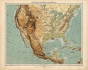
Vereinigte Staaten und Mexiko (United States and Mexico)
Date d'édition : 1902
Vendeur : Art Source International Inc., Boulder, CO, Etats-Unis
Evaluation du vendeur :
This map was produced for the 1902 Diercke, Schul-Atlas fur Hohere Lehranstalten, (Diercke Education Atlas for Higher Educational Institutions) This atlas was prepared and issued by C. Diercke and E.Gaebler for the Westermann publishing group in Braunschweig. With the help of fellow cartographer, Eduard Gaebler, Carl Dierckes maps became a staple in the geography classrooms in Germany. From 1893 until his death, Diercke was editor of all the maps for Westermann Verlag. All text is in German with full color that has remained quite bold. A wonderful example of the fine German engraving work of the time. These beautiful, topographic maps show the physical attributes and contours of the land as well as identifies cities, countries, rivers, mountains, boundaries, and more. They are double sided maps (shown side by side in image) which have corresponding information to the country on the opposite side. This map shows the United States and Mexico on one side and six smaller maps with information on North America including: New York u. Umgegend (New York and environs), Baltimore u. Washington, Verbreitung der Neger u. Indianer (Dissemination of Negroes and Indians), Verbreitung der Deutschen (Dissemination of the German), Nationalpark (National Park - Yellowstone), and S. Francisco u. Umgegend (San Francisco and environs). There is also a single side topographic map of the West Indies which includes the islands of the Bahamas and Central America. This map measures 12 inches by 15 inches.